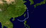
2018 Pacific typhoon season
| 2018 Pacific typhoon season | |
|---|---|
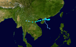
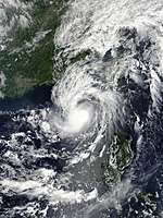
 Season summary map | |
| Seasonal boundaries | |
| First system formed | December 29, 2017 |
| Last system dissipated | Season ongoing |
| Strongest storm | |
| Name | Mangkhut |
| • Maximum winds |
205 km/h (125 mph) (10-minute sustained) |
| • Lowest pressure | 905 hPa (mbar) |
| Seasonal statistics | |
| Total depressions | 36 official, 1 unofficial |
| Total storms | 25 official, 1 unofficial |
| Typhoons | 11 |
| Super typhoons | 6 (unofficial) |
| Total fatalities | > 338 total |
| Total damage | > $7.38 billion (2018 USD) |
| Related articles | |
The 2018 Pacific typhoon season is an ongoing event in the annual cycle of tropical cyclone formation, in which tropical cyclones form in the western Pacific Ocean. The season runs throughout 2018, though most tropical cyclones typically develop between May and October. The season's first named storm, Bolaven, developed on January 3. The season's first typhoon, Jelawat, reached typhoon status on March 29, and became the first super typhoon of the year on the next day.
The scope of this article is limited to the Pacific Ocean, to the north of the equator between 100°E and the 180th meridian. Within the northwestern Pacific Ocean, there are two separate agencies that assign names to tropical cyclones, which can often result in a cyclone having two names, one from the JMA and one from PAGASA. The Japan Meteorological Agency (JMA) will name a tropical cyclone should it be judged to have 10-minute sustained wind speeds of at least 65 km/h (40 mph) anywhere in the basin, while the Philippine Atmospheric, Geophysical and Astronomical Services Administration (PAGASA) assigns names to tropical cyclones which move into or form as a tropical depression in their area of responsibility located between 135°E and 115°E and between 5°N–25°N regardless of whether or not a tropical cyclone has already been given a name by the JMA. Tropical depressions that are monitored by the United States' Joint Typhoon Warning Center (JTWC) are given a number with a "W" suffix.
Seasonal forecasts
| TSR forecasts Date | Tropical storms | Total Typhoons | Intense TCs | ACE | Ref |
|---|---|---|---|---|---|
| Average (1965–2017) | 26 | 16 | 9 | 294 | [1] |
| May 11, 2018 | 27 | 17 | 9 | 307 | [1] |
| July 6, 2018 | 27 | 17 | 10 | 331 | [2] |
| August 7, 2018 | 27 | 17 | 9 | 319 | [3] |
| Other forecasts Date | Forecast Center | Period | Systems | Ref | |
| January 15, 2018 | PAGASA | January–March | 1–3 tropical cyclones | [4] | |
| January 15, 2018 | PAGASA | April–June | 2–4 tropical cyclones | [4] | |
| March 15, 2018 | VNCHMF | January–December | 12–13 tropical cyclones | [5] | |
| March 23, 2018 | HKO | January–December | 5–8 tropical cyclones | [6] | |
| July 13, 2018 | PAGASA | July–September | 6–8 tropical cyclones | [7] | |
| July 13, 2018 | PAGASA | October–December | 4–6 tropical cyclones | [7] | |
| 2018 season | Forecast Center | Tropical cyclones | Tropical storms | Typhoons | Ref |
| Actual activity: | JMA | 36 | 25 | 11 | |
| Actual activity: | JTWC | 31 | 26 | 13 | |
| Actual activity: | PAGASA | 17 | 14 | 5 | |
During the year several national meteorological services and scientific agencies forecast how many tropical cyclones, tropical storms, and typhoons will form during a season and/or how many tropical cyclones will affect a particular country. These agencies included the Tropical Storm Risk (TSR) Consortium of University College London, PAGASA and Taiwan's Central Weather Bureau. The first forecast of the year was released by PAGASA during January 15, within its seasonal climate outlook for the period January–June.[4] The outlook noted that one to three tropical cyclones were expected between January and March, while two to four were expected to develop or enter the Philippine Area of Responsibility between April and June.[4] PAGASA also mentioned that the La Niña would be short-lived, predicting that it would last until February or April.[4]
On March 15, the Vietnamese National Center for Hydro Meteorological forecasts (VNCHMF) predicted that roughly twelve to thirteen tropical cyclones would affect Vietnam during 2018, which is above average.[5] On March 23, the Hong Kong Observatory predicted that five to eight tropical cyclones would come within 500 kilometres of Hong Kong, which is normal to above normal, with the first tropical cyclone affecting Hong Kong in June or earlier.[6] On May 11, the Tropical Storm Risk (TSR) issued their first forecast for the season, predicting that the 2018 season would be a slightly above average season producing 27 named storms, 17 typhoons, and nine intense typhoons.[1] The TSR released their second forecast on July 6, still predicting that the season will be an above average with the only changes to their forecast is increasing the number of intense typhoons from 9 to 10.[2] The PAGASA issued their second and final outlook on July 13, predicting for the period of July – December, where six to eight tropical cyclones were expected to develop or entered their area of responsibility between July and September, while four to six were forecast during October to December. On August 7, TSR released their final forecast, with its only changes decreasing the numbers of intense typhoons from 10 to 9 as well as its ACE to 319 units.[3]
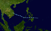
Season summary
2018 opened with Tropical Depression Agaton active to the east of the Philippines. Over the course of two days, the system moved over to the South China Sea and intensified into the first named storm, Bolaven. A month later, Tropical Storm Sanba developed and affected the southern Philippines. About another month later, Tropical Depression 03W formed in the open Pacific and was named Jelawat. Jelawat intensified into the season's first typhoon on March 30, and then the season's first super typhoon. Tropical activity fired up by June, when a series of storms developed, with Tropical Storm Ewiniar making landfall over mainland China. Later that month, Typhoon Prapiroon developed and affected the Korean Peninsula, the first since 2013. Thereafter, Typhoon Maria developed and reached its peak intensity as a Category 5 super typhoon, being the first typhoon to reach that intensity since Typhoon Nock-ten in 2016. Hurricane Hector crossed the International Date Line on August 13, the first to do so since Genevieve in 2014. Systems like Tropical Storm Son-tinh, Ampil, Josie, Wukong, Jongdari, Shanshan, Yagi, Leepi, Bebinca, and Rumbia from late July to early August.
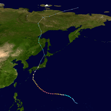
On August 16, Typhoon Soulik developed and headed north, until the Fujiwhara Effect with Typhoon Cimaron, which formed later than Soulik, made it head west towards the East China Sea. It later made a direct impact in South Korea, making it the first typhoon to make direct impact in South Korea since Typhoon Chaba in 2016. Cimaron made landfall near Kyoto, Japan on the 23rd of August. By Cimaron nearing to landfall, Tropical Depression Luis formed, which made landfall in China and Taiwan. Later in that month, Typhoon Jebi developed over the West Pacific and intensified into the third super typhoon of the season. In September, Typhoon Mangkhut became known as Typhoon Ompong which became the fourth super typhoon of the season and threatened Luzon island of the Philippines. On the same days, Tropical Depression Neneng formed, which later became Tropical Storm Barijat and made landfall on Vietnam. By late September, Typhoon Trami (Paeng) formed, becoming the 5th super typhoon of 2018.
Systems
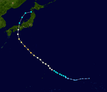
Tropical Storm Bolaven (Agaton)
| Tropical storm (JMA) | |
| Tropical depression (SSHWS) | |
  | |
| Duration | December 29, 2017 – January 4, 2018 |
|---|---|
| Peak intensity | 65 km/h (40 mph) (10-min) 1002 hPa (mbar) |
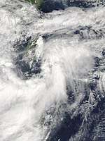
A low-pressure area developed into a tropical depression northeast of Palau on December 29, 2017.[8] The system moved generally westward and on the first day of 2018, the PAGASA began issuing advisories on the system and locally named it Agaton.[9] Both the JMA and the JTWC followed suit, with the latter designating the system as 01W.[10] By January 3, the system had intensified into a tropical storm according to the JMA and was named Bolaven, thus becoming the first named storm of the season. However, several hours later, Bolaven started to weaken and rapidly deteriorate.[11] The system was last tracked by the JMA to the east of Vietnam on January 4.
The impact caused by Bolaven (Agaton) was moderate but not as significant as the previous two systems, Kai-tak and Tembin, with about 2,000 passengers stranded in ports in the Visayas.[12] As of July 5, three people have been reported killed by the storm, while total damages were up to 554.7 million pesos (US$11.1 million).[13]
Tropical Storm Sanba (Basyang)
| Tropical storm (JMA) | |
| Tropical storm (SSHWS) | |
  | |
| Duration | February 8 – February 16 |
|---|---|
| Peak intensity | 65 km/h (40 mph) (10-min) 1000 hPa (mbar) |
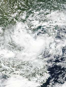
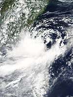
A low-pressure system developed into a tropical depression north of Chuuk early on February 8. It developed into a tropical storm on February 11, receiving the international name Sanba by the JMA. Shortly afterwards, Sanba entered the Philippine area of responsibility and received the name Basyang by PAGASA.[14] On February 13, Sanba made landfall in Cortes, Philippines,[15] causing it to weaken to a tropical depression. The next day, the system weakened into a remnant low as it made another landfall in Surigao del Sur.[16]
Approximately 17,000 people were affected by the storm and there were 14 fatalities. Total agricultural damages were at Php 167.955 million (US$3.2 million).[17]
Typhoon Jelawat (Caloy)
| Typhoon (JMA) | |
| Category 4 super typhoon (SSHWS) | |
  | |
| Duration | March 24 – April 1 |
|---|---|
| Peak intensity | 195 km/h (120 mph) (10-min) 915 hPa (mbar) |
On March 24, a tropical depression formed to the south of the Mariana Islands,[18] and the JTWC assigned it the numerical identifier 03W.[19] On March 25, the system intensified into a tropical storm and was named Jelawat by the JMA.[20] Due to strong southwesterly wind shear, the cyclone remained poorly organized, with disorganized convection near an exposed low-level circulation.[21] Conditions gradually became more favorable for further development, resulting in Jelawat steadily strengthening and organization to a severe tropical storm at 18:00 UTC on March 28.[22] Later on March 29, an eye began to emerge within a growing central dense overcast, leading to the JMA classifying it as a typhoon at 00:00 UTC on March 29.[23] Explosive intensification then ensued over the following 36 hours as the eye became sharply defined, and Jelawat attained its peak intensity later that morning, with estimated 10-minute sustained winds of 195 km/h (120 mph) and a central pressure of 915 hPa (27.02 inHg).[24] At the same time, the JTWC assessed it as peaking with 1-minute sustained winds of 240 km/h (150 mph), making it a Category 4 super typhoon.[25]
Immediately after peaking in intensity, Jelawat began weakening rapidly, due to a sharp increase in wind shear and dry air, and the storm fell below typhoon strength late on March 31. During the next couple of days, Jelawat drifted to the northeast, and then turned eastward, before dissipating on April 1.
The storm brought minor impacts to Palau, the Caroline Islands, and the Northern Mariana Islands.
Tropical Depression 04W
| Tropical depression (JMA) | |
| Tropical storm (SSHWS) | |
  | |
| Duration | May 10 – May 15 |
|---|---|
| Peak intensity | <55 km/h (35 mph) (10-min) 1008 hPa (mbar) |
A low-pressure area east of Mariana Islands was upgraded to a tropical depression by the JMA late on May 10,[26] shortly before the JTWC issued a TCFA.[27] By May 12, deep convection was observed near its center as the JTWC began issuing advisories on the system giving the designation 04W.[28] Roughly twelve hours later, it was reported that 04W had intensified into a tropical storm by the JTWC after satellite imagery had depicted on a well-defined center.[29] Tracking in a course of a west-northwesterly direction, the system began to weaken as it started entering in an area of unfavorable conditions.[30] Therefore, 04W rapidly weakened as the JTWC issued their final advisory on the system early on May 14, as the system showed a very elongated and exposed center, due to very strong wind shear.[31] The JMA, however, tracked the system until early on May 15, when it finally dissipated.[32]
Tropical Storm Ewiniar
| Tropical storm (JMA) | |
| Tropical storm (SSHWS) | |
  | |
| Duration | June 2 – June 9 |
|---|---|
| Peak intensity | 75 km/h (45 mph) (10-min) 998 hPa (mbar) |
A low-pressure area developed into a tropical depression over the South China Sea on June 2.[33][34] Later that day the JTWC followed suit and designated the system as 05W.[35] 05W meandered in a westward direction until it curved northward and after three days, the JTWC upgraded the system to a tropical storm.[36] The JMA did the same three hours later early on June 6, naming it Ewiniar.[37] Shortly thereafter, Ewiniar made landfall over South China. Ewiniar maintained its intensity while over land until the JTWC issued its final advisory late on June 7.[38] The JMA, however, tracked the system until early on June 9, when Ewiniar had weakened into a tropical depression and degenerated into a remnant low.[39] However, Ewiniar's remnant moved out to sea and continued to persist, before dissipating on June 13.
8 people were killed in China, while total economic losses were estimated at CN¥3.67 billion (US$573 million).[40]
Severe Tropical Storm Maliksi (Domeng)
| Severe tropical storm (JMA) | |
| Tropical storm (SSHWS) | |
  | |
| Duration | June 3 – June 11 |
|---|---|
| Peak intensity | 110 km/h (70 mph) (10-min) 970 hPa (mbar) |
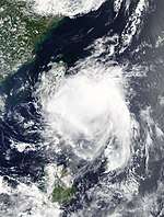
A low-pressure area northwest of Palau developed into a tropical depression late on June 3.[41] On the next day, the system received the name Domeng from PAGASA, while the JTWC issued a TCFA for the system.[42][43] After the system had consolidated further, the JMA finally upgraded the system to a tropical storm, naming it Maliksi.[41] The JTWC, however, didn't track the system until 03:00 UTC of June 8 when it also gave the designation 06W.[44] Moving northward, Maliksi continued to intensify until it reached its peak strength early on June 10 with winds of 110 km/h (70 mph), just shy of typhoon intensity, and a minimum pressure of 970 hPa.[41][45] Operationally, the JMA briefly classified Maliksi to a typhoon, but was downgraded to a severe tropical storm in post-analysis.[46] Afterwards, Maliksi began to weaken as it begins its extratropical transition. Encounting unfavorable environments by June 11, both agencies immediately stopped warning on the system as the system's center became exposed as the system was declared as an extratropical cyclone.[41][47] The JMA had tracked the remnants of Maliksi until 00:00 UTC of June 13.[41]
Despite not making landfall in the Philippines, Maliksi prompted the PAGASA to declare the official start of the rainy season on June 8, 2018. Two people were killed by heavy monsoonal rains, enhanced by Maliksi, in the Philippines.[48]
Tropical Storm 07W
| Tropical storm (SSHWS) | |
  | |
| Duration | June 13 – June 15 |
|---|---|
| Peak intensity | 65 km/h (40 mph) (1-min) 993 hPa (mbar) |
A disturbance formed southwest of Taiwan on June 12, just within the meiyu front, and the JTWC indicated a subtropical depression subsequently.[49] By 21:00 UTC of June 13, the JTWC issued its first advisory on the system, designating it as 07W, and was classified as a tropical depression.[50] Despite located in a moderately to a severely sheared environment, the system was located over in relatively warm sea-surface temperatures with patches of convection, and this prompted the JTWC to upgrade 07W to a tropical storm.[51] The JTWC later issued their fourth but final advisory on 07W on 15:00 UTC of June 14, when the system was rapidly undergoing a phase of extratropical transition as the system was losing its structure rapidly.[52] 07W fully became an extratropical cyclone just to the south of mainland Japan on 06:00 UTC of June 15, although its remnant was still tracked until June 25, when the system was last located near the coast of British Columbia.[49]
Tropical Storm Gaemi (Ester)
| Tropical storm (JMA) | |
| Tropical storm (SSHWS) | |
  | |
| Duration | June 13 – June 16 |
|---|---|
| Peak intensity | 85 km/h (50 mph) (10-min) 990 hPa (mbar) |
On June 13, a tropical depression formed on the South China Sea, from Tropical Storm 07W's trough. On June 14, the PAGASA announced it had entered the Philippine Area of Responsibility, assigning the name Ester. Tropical Depression Ester (08W) made landfall by midnight, and after intensifying into a tropical storm had been assigned the name Gaemi by the JMA. On June 16, Gaemi became extratropical. On June 19, the NDRRMC reported that 3 people had died from monsoonal rains enhanced by Gaemi.[53]
Typhoon Prapiroon (Florita)
| Typhoon (JMA) | |
| Category 1 typhoon (SSHWS) | |
  | |
| Duration | June 28 – July 4 |
|---|---|
| Peak intensity | 120 km/h (75 mph) (10-min) 960 hPa (mbar) |
A low-pressure area west of Okinotorishima developed into a tropical depression on June 28. On the next day, PAGASA began issuing advories, giving the name Florita. 6 hours later, Florita became a tropical storm, with JMA assigning Prapiroon for the international name. On June 30, Prapiroon began to intensify into a tropical storm. By July 2, Prapiroon became a Category 1 Typhoon, nearing Japan and Korea. By July 3, Typhoon Prapiroon had peak intensity. On the same day, Prapiroon made landfall on Japan. After landfall, Prapiroon briefly weakened to a tropical storm. Prapiroon became a low-pressure area on the next day, though the JMA still tracked its remnants until July 10, when it finally dissipated. [54][55]
As of July 2018, only 1 person was killed by the storm, who was from South Korea.[56]
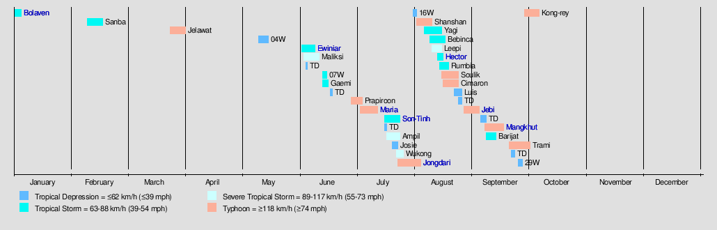
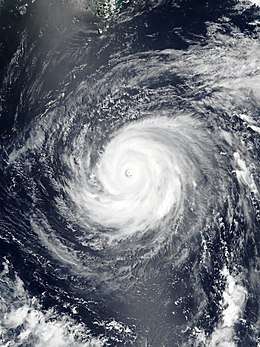
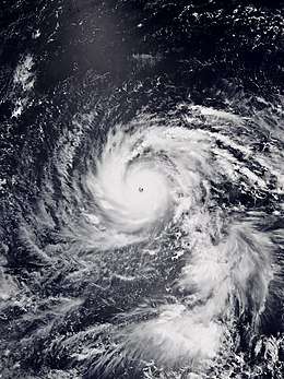
Typhoon Maria (Gardo)
| Typhoon (JMA) | |
| Category 5 super typhoon (SSHWS) | |
  | |
| Duration | July 3 – July 12 |
|---|---|
| Peak intensity | 195 km/h (120 mph) (10-min) 915 hPa (mbar) |
A tropical depression formed on July 3. On the next day, the system intensified into Tropical Storm Maria. Early on July 5, Maria intensified into a severe tropical storm, while the JTWC classified the system as a Category 1 typhoon. Explosive intensification ensued, and later that day, Maria became a super typhoon and the first Category 5-equivalent storm of this basin since Nock-ten in 2016. Shortly afterwards, Maria underwent an eyewall replacement cycle, and it weakened below super typhoon status the following day. By July 8, however, Maria had completed the eyewall replacement cycle and regained Category 5-equivalent intensity.
Tropical Storm Son-Tinh (Henry)
| Tropical storm (JMA) | |
| Tropical storm (SSHWS) | |
  | |
| Duration | July 16 – July 24 |
|---|---|
| Peak intensity | 75 km/h (45 mph) (10-min) 994 hPa (mbar) |
An area of low-pressure strengthened into a tropical depression on July 15, to the northwest of Manila, Philippines.[57] The JTWC designated it as 11W while the PAGASA named it Henry.[57] As the system moved in a fast westward direction, the system gradually intensified and was declared a tropical storm by July 17, with the JMA naming it as Son-Tinh as its convective structure improved.[58] Although from thereafter, Son-Tinh slightly weakened as it neared Hainan island while experiencing moderate shear.[59] During the next day, however, Son-Tinh slightly intensified over in the Gulf of Tonkin due to warm sea-surface temperatures before it made landfall in northern Vietnam.[60] Both agencies issued their final warning on Son-Tinh on July 19 as the system had weakened back into an area of low-pressure embedded by the monsoon.[61] However, the JTWC continued to track the system's remnant low for another two days, before it finally dissipated.[62]
Severe Tropical Storm Ampil (Inday)
| Severe tropical storm (JMA) | |
| Tropical storm (SSHWS) | |
  | |
| Duration | July 17 – July 24 |
|---|---|
| Peak intensity | 95 km/h (60 mph) (10-min) 985 hPa (mbar) |
On July 17, a weak tropical depression had developed over in the Philippine Sea. With some deep convection and the system located in favorable environments, the JTWC began tracking on the system, designating it as 12W.[63] By the next day, the PAGASA followed suit and was locally named as Inday. By 12:00 UTC of July 18, the system had intensified into a tropical storm and was named Ampil.[64] As Ampil moved in a northward direction, the system's structure had broadened along with sustained deep convection.[65] Despite an unfavorable ocean heat content, Ampil still remained over relatively warm sea-surfaces temperatures with the inclusion of an extensive deep convection,[66] therefore Ampil was classified as a severe tropical storm. With an improved convective system, the JTWC assessed that Ampil had reached 1-minute peak winds of 95 km/h (60 mph).[67] Ampil reached its peak intensity with a minimum pressure of 985 hPa and maintained that intensity for the next few days, despite with the change of direction. On July 21, the system's center became exposed as the system slightly weakened.[68] By the next day, the JMA downgraded Ampil back to a tropical storm, as the system made landfall over China with a lack of convection.[69] Ampil weakened further to a tropical depression on July 23, and both agencies issued their final advisory on the system.[70] The JMA continued tracking the system until it weakened into an area of low pressure, at 18:00 UTC on July 24.[71]
Heavy rain in Shandong Province—accumulating to 237 mm (9.3 in) in Tianjin—caused significant flooding, inundating 31,600 hectares of crops and affecting 260,000 people. One person was killed in China and total economic losses reached ¥1.19 billion (US$175.2 million).[72]
Tropical Depression 13W (Josie)
| Tropical depression (JMA) | |
| Tropical depression (SSHWS) | |
  | |
| Duration | July 20 – July 23 |
|---|---|
| Peak intensity | 55 km/h (35 mph) (10-min) 996 hPa (mbar) |
A Tropical Depression formed on the South China Sea on July 20, according to the JMA. On July 21, the system entered the PAGASA's Philippine Area of Responsibility or PAR, and was named Tropical Depression Josie, the 10th named storm to enter the PAR this 2018 Pacific typhoon season. Tropical Depression Josie missed kilometers off of landfall in Saud, Ilocos Norte. Tropical Depression Josie moved north, and exited the PAR by the next day. While approaching China, Josie approached the mainland of China about to become a named tropical storm, but missed Tropical Storm strength and was destroyed by high wind shear near China. The remnants of Josie headed inland to mainland China, where it fully dissipated.
Since the formation of the previous two systems, the southwest monsoon had been extremely active in the Philippines. By August 1, a total of 16 people had been killed due to extreme flooding, while damages have been recorded at ₱4.66 billion (US$87.4 million). The southwest monsoon had been active since Typhoon Maria (Gardo), Tropical Storm Son-Tinh (Henry) and Severe tropical storm Ampil (Inday). July had 5 days of class supensions in Metro Manila, 2nd in history since Typhoon Ketsana (Ondoy) struck Metro Manila and caused ocean-high flooding last 2009 Pacific typhoon season. [73]
Severe Tropical Storm Wukong
| Severe tropical storm (JMA) | |
| Category 1 typhoon (SSHWS) | |
  | |
| Duration | July 22 – July 26 |
|---|---|
| Peak intensity | 95 km/h (60 mph) (10-min) 990 hPa (mbar) |
Late on July 21, the JTWC began to issue advisories on Tropical Depression 14W that had developed about 603 km (381 mi) east-southeast of the Japanese island of Minami-Tori-shima.[74] The JMA, however, began tracking the system until the early hours of July 22. Later that day, the JTWC upgraded 14W to a tropical storm, despite the fact that convection had been sheared and the system was located in unfavorable southwesterly shear.[75] Within the next 24 hours, 14W began to organize with deep convection obscuring its LLCC,[76] and on 12:00 UTC of July 23, the JMA upgraded the system to a tropical storm, naming it Wukong. Moving poleward, Wukong gradually intensified while entering in an area of favorable environment with lesser shear and on 00:00 UTC of July 25, the JMA upgraded Wukong to a severe tropical storm. Nine hours later, the JTWC upgraded Wukong to a Category 1 typhoon after satellite images depicted a 30-nmi ragged eye.[77] Though by July 26, both the JMA and the JTWC issued their final advisory on Wukong as the system had rapidly transitioned into an extratropical cyclone.[78] Wukong's extratropical remnants was tracked until late on July 27 when it was last noticed off the eastern coast of Russia Far East.[79]
Typhoon Jongdari
| Typhoon (JMA) | |
| Category 2 typhoon (SSHWS) | |
  | |
| Duration | July 23 – August 4 |
|---|---|
| Peak intensity | 140 km/h (85 mph) (10-min) 960 hPa (mbar) |
Typhoon Jongdari was a strong, long-lived and erratic tropical cyclone that impacted Japan and East China in late July and early August 2018. Formed as the twelfth named storm of the 2018 typhoon season near Okinotorishima on July 24, Jongdari gradually intensified and developed into the fourth typhoon of the year on July 26. Influenced by an upper-level low and a subtropical ridge, Jongdari executed a rare counter-clockwise southeast of Japan on the next day. At that time, it also reached peak intensity. The typhoon made landfall in Kii Peninsula, over Mie Prefecture of Japan locally early on July 29.
Tropical Depression 16W
| Tropical depression (JMA) | |
| Tropical depression (SSHWS) | |
  | |
| Duration | July 31 – August 2 |
|---|---|
| Peak intensity | 55 km/h (35 mph) (10-min) 1000 hPa (mbar) |
A tropical disturbance developed about 807 km (503 mi) north-northeast of Iwo To by July 29.[80] The JTWC upgraded the system to Tropical Depression 16W during the next day after its convective structure had slightly improved despite the system located in moderate to strong wind shear.[81] By July 31, the JMA followed suit on classifying the system as a tropical depression.[82] 16W's center late became exposed with deep convection displaced due to continued shear.[83] Originally, the system was forecast to reach tropical storm intensity with only 35 knot winds,[84] but the system's center had become asymmetric with a fully sheared center.[85] The JTWC issued their final advisory on 21:00 UTC of the same day, after 16W had fully transitioned into a subtropical cyclone, though both agencies continued to track the system until August 2.[86][87]
Typhoon Shanshan
| Typhoon (JMA) | |
| Category 2 typhoon (SSHWS) | |
  | |
| Duration | August 2 – August 10 |
|---|---|
| Peak intensity | 130 km/h (80 mph) (10-min) 970 hPa (mbar) |
A tropical depression had developed to the east-northeast of Guam on August 2. On 21:00 UTC of the same day, the JTWC began tracking the system, giving the identifier 17W.[88] 17W intensified into a tropical storm on August 3, with the JMA naming it as Shanshan.[89] The storm was located over in favorable environments as the system was gradually consolidating,[90] therefore Shanshan intensified into a severe tropical storm. During the next day, both the JMA and JTWC upgraded Shanshan to a typhoon after deep convection was seen wrapping into its developing center. The JMA later analysed that the storm had reached 10-minute winds of 130 km/h (80 mph) and a minimum pressure of 970 hPa, and remain that intensity for several days. Though the JTWC stated that Shanshan had slightly weakened after a strengthening trend by August 6 after its eye became ragged and slightly displaced. However, on August 7, Shanshan began to re-intensify and reached its peak strength as a Category 2 typhoon with 1-minute winds of 165 km/h (105 mph) while nearing the coast of southeastern Japan. Thereafter, Shanshan began to change its course towards the east as it rapidly weakened. The JTWC issued their final advisory on August 9, though the JMA tracked the system until it became extratropical at 06:00 UTC on August 10.
Tropical Storm Yagi (Karding)
| Tropical storm (JMA) | |
| Tropical storm (SSHWS) | |
  | |
| Duration | August 6 – August 15 |
|---|---|
| Peak intensity | 75 km/h (45 mph) (10-min) 990 hPa (mbar) |
A tropical disturbance had persisted towards the southwest of Iwo To on August 1.[91] After the course of five days, the system finally strengthened into a tropical depression by the JMA, with the JTWC following suit several hours later (designating it as 18W).[92] The PAGASA also began issuing bulletins to the system, locally assigning the name Karding. Karding maintained its intensity as a tropical depression due to moderate to strong easterly shear, despite persistent convection surrounding the system.[93] By August 8, a METOP-A ASCAT image showed that the system had winds of 35 knots, hence the JTWC upgrading it to a tropical storm.[94] The JMA around the same time did the same, naming it Yagi. Within the next day, Yagi curved towards the northwest while continuously battling shear as it struggled to intensify. Though by 12:00 UTC of August 11, the JMA considered that Yagi reached its peak strength with 10-minute winds of 75 km/h (45 mph) and a minimum pressure of 990 hPa.
The JTWC declared that Yagi reached winds of 85 km/h (50 mph) on 12:00 UTC of August 12 after the storm had consolidated further with an improved structure.[95] Yagi made landfall shortly thereafter over Wenling, in Taizhou of Zhejiang, China, at around 23:35 CST (15:35 UTC) on August 12.[96] By 21:00 UTC of that day, the JTWC issued their final advisory on Yagi,[97] but continued to track it until it weakened further into a tropical depression early on August 13.[98] The JMA did the same on 06:00 UTC of August 13, but continued to tracked it until it became an extratropical system on August 15. Although Yagi (Karding) didn't make landfall in the Philippines, the storm enhanced the southwest monsoon which brought extreme flooding towards many regions within the country. According to the NDRRMC, two people died along with ₱996 million (2018 PHP, US$18.7 million) worth of damages, as of August 26.[99] In East China, Yagi killed a total of 2 people and total damages were counted to be CN¥380 million (US$55.5 million).[100]
Tropical Storm Bebinca
| Tropical storm (JMA) | |
| Tropical storm (SSHWS) | |
  | |
| Duration | August 9 – August 17 |
|---|---|
| Peak intensity | 85 km/h (50 mph) (10-min) 985 hPa (mbar) |
On August 9, a tropical depression formed within the South China Sea. The system remained weak and remained stationary for a few days until the JTWC began tracking on the system, designating it as 20W on August 12.[101] By August 13, the JMA finally upgraded the system to a tropical storm, naming it Bebinca. The JTWC followed suit nine hours later when they found flaring deep convection near its compact center.[102] Despite consistent convection along with warm sea-surface temperatures, Bebinca remain weak for the next few days due to strong shear.[103] Although by August 16, Bebinca began to undergo a phase of rapid intensification as its center was obscured by a central dense overcast,[104] and thus, the JMA briefly upgraded Bebinca to a severe tropical storm. The JTWC analysed a few hours later that the system had reached peak intensity with 1-minute winds of 110 km/h (70 mph). After Bebinca made landfall, the system rapidly weakened and both agencies issued their final warning on August 17, and fully dissipated that same day.
Bebinca killed a total of 3 people and total economic losses in South China were counted to be CN¥1.6 billion (US$231 million).[105]Total damages in Vietnam were counted to be 800 billion ₫ (US$34.4 million).[106]
Severe Tropical Storm Leepi
| Severe tropical storm (JMA) | |
| Category 1 typhoon (SSHWS) | |
  | |
| Duration | August 10 – August 15 |
|---|---|
| Peak intensity | 95 km/h (60 mph) (10-min) 994 hPa (mbar) |
On August 11, a tropical depression became Tropical Storm Leepi the next day. By August 13, Tropical Storm Leepi threatened Japan. By August 14, Leepi became a severe tropical storm or a Category 1 typhoon for JTWC. Shortly before 03:00 JST (18:00 UTC) on August 15, Leepi made landfall over Hyūga, Miyazaki in Japan. It finally dissipated on August 15 as a extratropical system with no more energy left. Still, its remnants still headed out to mainland Russia. [107] Leepi dissipated on August 16, after the system was last tracked east of South Korea as a remnant low.
Tropical Storm Hector
| Tropical storm (JMA) | |
| Tropical storm (SSHWS) | |
  | |
| Duration | August 13 (Entered basin) – August 16 |
|---|---|
| Peak intensity | 75 km/h (45 mph) (10-min) 998 hPa (mbar) |
On August 13 at 18:00 UTC, both the JMA and the JTWC declared that Tropical Storm Hector from the East Pacific basin had crossed the International Dateline and entered the West Pacific basin.[108] At this point, Hector was still located in a favorable environment with only moderate shear, though deep convection was limited as it only persisted just near its center.[109] Due to an upper tropospheric trough cell located to the west of Hector, the storm failed to intensify and began to weaken.[110] The JTWC downgraded Hector to a tropical depression after the system rapidly entered an area of high vertical wind shear.[111] By the early hours of August 15, both agencies issued their final warning on Hector, mentioning that Hector's LLCC had become elongated and that the storm already transitioned into a subtropical cyclone.[112] The JMA, however, continued to monitor the system until 00:00 UTC on August 17.
Tropical Storm Rumbia
| Tropical storm (JMA) | |
| Tropical storm (SSHWS) | |
  | |
| Duration | August 14 – August 19 |
|---|---|
| Peak intensity | 85 km/h (50 mph) (10-min) 985 hPa (mbar) |
On August 15, a tropical depression in the East China Sea strengthened into Tropical Storm Rumbia. Shortly after reaching peak intensity over the Hangzhou Bay on August 16, Rumbia made landfall over Pudong New Area, Shanghai, China at around 04:05 CST on August 17 (20:05 UTC), becoming the third tropical storm to hit Shanghai in 2018.[113]
Rumbia killed a total of 22 people in East China and total economic losses were counted to be CN¥9.2 billion (US$1.34 billion).[114][115] Shouguang where 174.7 mm (6.88 in) of rain fell, was particularly hard-hit, with 10,000 homes destroyed and 13 people killed. The city is regarded as the nation's greatest producer of vegetables and agriculture suffered tremendous losses; 200,000 greenhouses sustained damage. Upstream on the Mi River rainfall reached 241.6 mm (9.51 in) and caused significant flooding. Water levels at three reservoirs rose dangerously high, prompting officials to release excess water to avoid collapse. The resulting increase downstream exacerbated the flooding in Shouguang. The extratropical remnants of Rumbia was last tracked northeast of Hokkaido before finally dissipating off the coast of the Russian Far East.[115]
Typhoon Soulik
| Typhoon (JMA) | |
| Category 3 typhoon (SSHWS) | |
  | |
| Duration | August 15 – August 24 |
|---|---|
| Peak intensity | 155 km/h (100 mph) (10-min) 950 hPa (mbar) |
A low-pressure area in the Philippine Sea organized into a tropical depression late on August 15. The JTWC followed suit at 00:00 UTC at August 16 and was designated as 22W. Later on that day, the JMA upgraded 22W to tropical storm and it was given the international name Soulik. On August 17, JMA upgraded Soulik to a typhoon, marking the sixth typhoon of the season. Then Soulik rapidly intensified onto a severe typhoon, and on the next day, Soulik reached its peak intensity, with winds of 165 km/h (103 mph), and remained that intensity for several days. After passing the Ryukyu Islands early on 22 August, the storm gradually weakened due to low sea-surface temperatures. On August 23, Soulik made landfall over Haenam County, South Jeolla Province of South Korea at around 23:00 KST (14:00 UTC).[116]
Total economic losses in Northeast China were counted to be CN¥550 million (US$79.9 million).[117]
Typhoon Cimaron
| Typhoon (JMA) | |
| Category 3 typhoon (SSHWS) | |
  | |
| Duration | August 16 – August 24 |
|---|---|
| Peak intensity | 155 km/h (100 mph) (10-min) 950 hPa (mbar) |
On August 16, a tropical depression formed near the Marshall Islands. It was named Tropical Storm Cimaron a day later. Severe Tropical Storm Cimaron rapidly intensified over the course from August 18-22. Typhoon Cimaron threatened Southern Japan, right after Typhon Soulik ravaged the area. Typhoon Cimaron peaked to a Category 3 major typhoon just right before its intense landfall in Japan. On August 23, Cimaron made landfall over the southern part of Tokushima Prefecture, Japan at around 21:00 JST (12:00 UTC). Typhoon Cimaron became Tropical Depression Cimaron before becoming extratropical and headed to the part of mainland Russia as nothing but just a weak low pressure remnant area that as once the devastating storm, Typhoon Cimaron. Cimaron was a significant Category 3 storm, and the 12th typhoon to strike Japan in 2018 and was surpassed by Typhoon Jebi a month later.[118] Then, it made landfall over Himeji, Hyōgo Prefecture shortly before 24:00 JST (15:00 UTC).[119]
Tropical Depression 24W (Luis)
| Tropical depression (JMA) | |
| Tropical depression (SSHWS) | |
  | |
| Duration | August 22 – August 26 |
|---|---|
| Peak intensity | 55 km/h (35 mph) (10-min) 994 hPa (mbar) |
A tropical depression formed at the South China Sea near Taiwan. Despite entering an area of high wind shear, the system was in a favorable environment, so the JTWC and the PAGASA followed suit, with the JTWC naming it 24W, and the PAGASA named it Luis. 24W then made landfall over Fujian, China shortly after 08:00 CST (00:00 UTC) on August 25 and degenerated into a low-pressure area next day.[120][121]
24W caused damages of 12.1 million and killed 6 people, including floods in Taiwan.
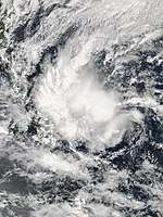
Typhoon Jebi (Maymay)
| Typhoon (JMA) | |
| Category 5 super typhoon (SSHWS) | |
  | |
| Duration | August 27 – September 7 |
|---|---|
| Peak intensity | 195 km/h (120 mph) (10-min) 915 hPa (mbar) |
Typhoon Jebi was a strong Category 5 typhoon that killed 17 people. Jebi affected the Mariana Islands, Taiwan, Japan, and the Russian Far East. Jebi first started off as a low-pressure system near the Marshall Islands on early August 25, but was upgraded to a tropical depression on August 27 by the Japan Meteorological Agency (JMA). There was a persistent deep convection in the system which lead to the upgrade to a tropical storm by the JMA and was given the name 'Jebi'. On August 29, the storm underwent rapid intensification and became the third super typhoon and the second category 5 of the season. On September 4, a weakened but still powerful Jebi made landfall over the southern part of Tokushima Prefecture at around 12:00 JST (03:00 UTC) before moving over Osaka Bay and making another landfall at around Kobe, Hyōgo Prefecture at around 14:00 JST (05:00 UTC). Osaka was hit badly with a maximum wind gust of 209 km/h recorded at Kansai International Airport and 171 km/h at Osaka city's weather station, where the minimum sea level pressure (962 mb) was the lowest since 1961's record of 937 mb (Typhoon Nancy) and the fifth lowest on record. A 3.29 metre storm surge led to flooding along the Osaka Bay, including Kansai International Airport, where the runways were flooded and some airport facilities were damaged by wind and water. Osaka's iconic Universal Studios Japan was also closed during the event of the typhoon. Wakayama also recorded a maximum wind gust of 207 km/h. Typhoon Jebi then moved over Kyoto which wrecked more havoc. Multiple shrines were closed during the duration of the typhoon. Kyoto Station received a lot of damage, the glass above the atrium covering the central exit, shops and hotel, collapsed, narrowly missing a few by centimeters. The typhoon ultimately emerged into the Sea of Japan shortly after 15:00 JST (06:00 UTC). Simultaneously, a cold front formed southwest of the typhoon, initiating the beginning of an extratropical transition on September 4. On September 5, after JTWC issued a final warning at 00:00 JST (15:00 UTC), Jebi was downgraded to a severe tropical storm at 03:00 JST (18:00 UTC) when it was located near the Shakotan Peninsula of Hokkaido. The storm completely transitioned into a storm-force extratropical cyclone off the coast of Primorsky Krai, Russia shortly before 10:00 VLAT (09:00 JST, 00:00 UTC). Later, the extratropical cyclone moved inland. The terrain of Khabarovsk Krai contributed to the steadily weakening trend as the system moved inland northwestward and then northward, before the extratropical low eventually dissipated northeast of Ayan early on September 7.
Typhoon Jebi was the strongest storm to hit Japan since Typhoon Yancy of 1993.
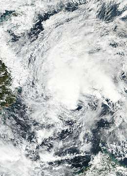
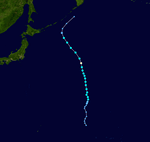
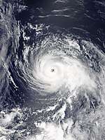
Typhoon Mangkhut (Ompong)
| Typhoon (JMA) | |
| Category 5 super typhoon (SSHWS) | |
  | |
| Duration | September 7 – September 17 |
|---|---|
| Peak intensity | 215 km/h (130 mph) (10-min) 905 hPa (mbar) |
On September 7, a tropical depression formed near the Marshall Islands, and the Japan Meteorological Agency (JMA) initiated advisories on the system. The JTWC followed suit at 03:00 UTC, and the system was classified as 26W. Late on the same day, the system strengthened into a tropical storm, and the JMA named the system Mangkhut. By September 11, Mangkhut became a typhoon, and made landfall on the islands of Rota, Northern Mariana Islands. On September 12, at 3 pm Philippine Standard Time, Typhoon Mangkhut entered the PAR as a Category 5 super typhoon, and accordingly, PAGASA named the storm Ompong. The JTWC noted additional strengthening on September 12, and assessed Mangkhut to have reached its peak intensity at 18:00 UTC, with maximum one-minute sustained winds of 285 km/h (180 mph). On September 13, the Philippine Government initiated evacuations for residents in the typhoon's expected path. Late on September 14, Mangkhut made landfall on the Philippines as a Category 5-equivalent super typhoon, with 1-minute sustained winds of 165 miles per hour (266 km/h).[122] While moving inland, Mangkhut weakened into a strong Category 4-equivalent super typhoon, and soon weakened further into a Category 2 typhoon. A large eye then appeared and the system slowly strengthened into a Category 3 typhoon, as the storm moved over Hong Kong. As Mangkhut made its final landfall, it weakened into a weak Category 1 typhoon and maintained its intensity inland with deep convection, before subsequently weakening further. Late on September 17, Mangkhut dissipated over Guangxi, China.
As of September 23, at least 134 fatalities have been attributed to Mangkhut, including 127 in the Philippines,[123][124] 6 in mainland China,[125] and 1 in Taiwan.[126] As of October 5, the NDRRMC estimated that Mangkhut caused ₱33.9 billion (US$627 million) in damages in the Philippines, with assessments continuing.[127]
Tropical Storm Barijat (Neneng)
| Tropical storm (JMA) | |
| Tropical storm (SSHWS) | |
  | |
| Duration | September 8 – September 13 |
|---|---|
| Peak intensity | 75 km/h (45 mph) (10-min) 998 hPa (mbar) |
On September 8, a tropical depression formed near Batanes in the Philippines. The storm was named Tropical Depression Neneng by PAGASA, with Batanes placed under TCWS #1. By the next day, Neneng exited the PAR and became a tropical storm, with the JMA assigning the name Barijat to the storm, while TCWs were raised in the absence of the storm. Over the next 2 days, Tropical Storm Barijat moved westward across the South China Sea. On September 13, Tropical Storm Barijat (Neneng) made landfall on the Leizhou Peninsula, near the area where Tropical Storm Son-tinh (Henry) had made landfall 2 months ago, before making a second landfall in northern Vietnam later on the same day. During the evening of September 13, Barijat became a remnant low, dissipating on the next day.
Tropical Storm Barijat made a dozen landslides over Batanes, which increases the risk of major landslides and major flooding in the saturated soil influenced by this storm and later by Mangkhut (Ompong).
Typhoon Trami (Paeng)
| Typhoon (JMA) | |
| Category 5 super typhoon (SSHWS) | |
  | |
| Duration | September 20 – October 1 |
|---|---|
| Peak intensity | 195 km/h (120 mph) (10-min) 915 hPa (mbar) |
The NRL began to monitor a large tropical disturbance that formed near Chuuk in the Federated States of Micronesia. The system drifted westwards and strengthened into a tropical depression on September 20 according to the JMA, while the JTWC issued a TCFA. Trami managed to find itself in favorable conditions for strengthening and on September 21, it gained tropical storm status and was named Trami. On September 22, Trami still strengthened and became a Severe Tropical Storm before strengthening to a Category 1 typhoon. On September 23, Trami, yet again in favorable conditions, continued to strengthen and became a Category 3-equivalent typhoon while undergoing a eyewall replacement cycle at the same time. Early on September 24, Trami strengthened further and attained Category 4 super typhoon status once it finished its eyewall replacement cycle. At 18:00 UTC on September 24, Trami strengthened even further and subsequently became a Category 5 super typhoon. On its route to Okinawa, Japan, Trami slowed down considerably and was almost stationary before moving north-northeastward. During this period of time, another eyewall replacement cycle that eventually failed later on, coupled with decreasing sea surface temperatures, started to slowly weaken Trami, although it still remained an organized storm. On September 30, Trami reached the most organized point of its duration after its peak, but Trami's structure started to began to deteriorate afterward, and the storm's winds gradually dropped as Trami resumed weakening. The typhoon made landfall over Tanabe, Wakayama Prefecture at around 20:00 JST (11:00 UTC) on September 30,[128] as a Category 2-equivalent typhoon. The storm's structure deteriorated rapidly after landfall, and the JMA issued their last advisory on Trami on October 1. After Trami impacted Honshu, it completely transitioned into a hurricane-force extratropical cyclone and impacted the Kuril Islands and weakened to a storm-force system. Its extratropical remnants were last tracked in the Bering Sea, near the Aleutian Islands.
Tropical Depression 29W
| Tropical depression (JMA) | |
| Tropical depression (SSHWS) | |
  | |
| Duration | September 25 – September 27 |
|---|---|
| Peak intensity | 55 km/h (35 mph) (10-min) 1008 hPa (mbar) |
On September 25, while moving northwestward, a low-pressure area had developed into a tropical depression, associated from the remnant energy from Hurricane Olivia.[129] The JTWC gave the designation 29W next day.[130] Remaining weak with an exposed low-level circulation center, the tropical depression accelerated northward and then north-northeastward until it was eventually absorbed into a developing extratropical cyclone east of Japan on September 27.[131][132]
Typhoon Kong-rey (Queenie)
| Typhoon (JMA) | |
| Category 5 super typhoon (SSHWS) | |
  | |
| Duration | September 28 – October 6 |
|---|---|
| Peak intensity | 195 km/h (120 mph) (10-min) 915 hPa (mbar) |
In late September 2018, a tropical disturbance formed in the waters near Pohnpei Island in the Federated States of Micronesia. The Joint Typhoon Warning Center also gave the rating to 94W "Low".[133] Over the next couple of days, the system moved westward and organized into a tropical depression on September 27, and the JMA initiated advisories on the storm, while the JTWC issued a TCFA. On 28 September, the JTWC designated the system as 30W,[134] while the JMA issued a gale warning for the system.[135] As Tropical Depression 30W continued strengthening, the system became a tropical storm and was named Kong-rey by the JMA. On 29 September, the system moved further west, found itself in favorable conditions for strengthening, and became a tropical storm. Later that day, Kong-rey strengthened into a severe tropical storm, and on September 30, the storm attained typhoon status at 03:00 UTC. Kong-rey continued strengthening, and at 18:00 UTC on October 1, Kong-rey became a Category 4-equivalent super typhoon. Early on October 2, Kong-rey strengthened into a Category 5 super typhoon. Affected by vertical wind shear, low ocean heat content and decreasing sea surface temperatures, the storm gradually weakened to a Category 3 typhoon on October 3 while undergoing an eyewall replacement cycle.[136] Increased vertical wind shear and lower sea surface temperatures hampered Kong-rey's strength, and Kong-rey was downgraded to a tropical storm on October 4. Early on October 6, Kong-rey made landfall in Tongyeong, South Gyeongsang Province in South Korea as a high-end tropical storm,[137] and later on the same day, Kong-rey transitioned into an extratropical cyclone, while impacting southern Hokkaido, such as areas near Hakodate.
As of October 2018, 3 people have been killed by the storm, including 2 people from South Korea.[138] Although Kong-Rey did not make a direct impact on Kyushu and Shikoku, its outer rainbands affected the two islands. At an area in Shikoku, rain accumlated to 300 mm. In Nagasaki, more than 12,000 families lost power;[139] in Fukuoka Prefecture, a person died because of the rain.[140]
Other systems
On June 4, the JMA began tracking on a weak tropical depression that had formed northeast of Yap.[141] However, the system was absorbed by a nearby tropical depression, which would eventually become Severe Tropical Storm Maliksi on the next day.[42] After Gaemi became extratropical, a tropical depression formed south of Hong Kong early on June 17, and dissipated over the east coast of Guangdong, China one day later.[142][143] On July 16, a tropical depression developed over the South China Sea. The system remained weak and moved into Vietnam, before dissipating on the next day. On August 4, the JTWC began to track a subtropical storm that had developed just west of the International Date Line; the storm subsequently became extratropical on the next day.[144]
A tropical depression formed southeast of Okinawa on August 24; two days later, it made landfall over Shanghai and quickly dissipated over Jiangsu, in East China.[145][146][147] The remnants associated with Hurricane Olivia entered this basin on September 19,[148][149] and it developed into a tropical depression on September 21 when drifting westward slowly.[150] Two days later, it degenerated into the remnants again, as JMA reported a dissipation.[151][152] The system's remnant energy developed into Tropical Depression 29W.
Storm names
Within the Northwest Pacific Ocean, both the Japan Meteorological Agency (JMA) and the Philippine Atmospheric, Geophysical and Astronomical Services Administration (PAGASA) assign names to tropical cyclones that develop in the Western Pacific, which can result in a tropical cyclone having two names.[153] The Japan Meteorological Agency's RSMC Tokyo – Typhoon Center assigns international names to tropical cyclones on behalf of the World Meteorological Organization's Typhoon Committee, should they be judged to have 10-minute sustained windspeeds of 65 km/h (40 mph).[154] PAGASA names tropical cyclones which move into or form as a tropical depression in their area of responsibility located between 135°E and 115°E and between 5°N and 25°N, even if the cyclone has had an international name assigned to it.[153] The names of significant tropical cyclones are retired, by both PAGASA and the Typhoon Committee.[154] Should the list of names for the Philippine region be exhausted then names will be taken from an auxiliary list of which the first ten are published each season. Unused names are marked in gray.
International names
A tropical cyclone is named when it is judged to have 10-minute sustained windspeeds of at least 65 km/h (40 mph).[155] The JMA selected the names from a list of 140 names, that had been developed by the 14 members nations and territories of the ESCAP/WMO Typhoon Committee.[156] The next 35 names on the naming list are listed here along with their international numeric designation, if they are used. During the season, the names Ampil, Jongdari and Barijat were used for the first time, after they replaced the names Bopha, Sonamu and Utor which were all retired after the 2012 and 2013 seasons respectively.
|
|
|
|
|
The international numeric designation 1817 was applied to Tropical Storm Hector after it crossed the International Date Line; its name was assigned by the National Hurricane Center.
Philippines
PAGASA uses its own naming scheme to name tropical cyclones that either develop within or move into their self-defined area of responsibility.[157] The list of names for this season was last used during 2014 and are scheduled to be used again during 2022.[157] All of the names are the same except for Gardo, Josie, Maymay, Rosita and Samuel, which replaced the names Glenda, Jose, Mario, Ruby and Seniang after they were retired.[157] So far, the names Gardo, Josie and Maymay were used for the first time.
|
|
|
|
|
Auxiliary list
|
|
|
|
|
Season effects
This table summarizes all the systems that developed within or moved into the North Pacific Ocean, to the west of the International Date Line during 2018. The tables also provide an overview of a systems intensity, duration, land areas affected and any deaths or damages associated with the system.
| Name | Dates active | Peak classification | Sustained wind speeds |
Pressure | Areas affected | Damage (USD) |
Deaths | Refs |
|---|---|---|---|---|---|---|---|---|
| Bolaven (Agaton) | December 29, 2017 – January 4, 2018 | Tropical storm | 65 km/h (40 mph) | 1002 hPa (29.59 inHg) | Philippines, Vietnam | $11.1 million | 3 | [13] |
| Sanba (Basyang) | February 8 – 16 | Tropical storm | 65 km/h (40 mph) | 1000 hPa (29.53 inHg) | Caroline Islands, Philippines | $3.2 million | 14 | [17] |
| Jelawat (Caloy) | March 24 – April 1 | Typhoon | 195 km/h (120 mph) | 915 hPa (27.02 inHg) | Caroline Islands | None | None | |
| 04W | May 10 – 15 | Tropical depression | Not specified | 1008 hPa (29.77 inHg) | None | None | None | |
| Ewiniar | June 2 – 9 | Tropical storm | 75 km/h (45 mph) | 998 hPa (29.47 inHg) | Vietnam, Philippines, South China, Taiwan, Ryukyu Islands | $573 million | 15 | [40][158][159] |
| Maliksi (Domeng) | June 3 – 11 | Severe tropical storm | 110 km/h (70 mph) | 970 hPa (28.64 inHg) | Ryukyu Islands, Philippines, Honshu | Minimal | 2 | [48] |
| TD | June 4 – 5 | Tropical depression | Not specified | 1006 hPa (29.71 inHg) | Guam | None | None | |
| 07W | June 13 – 15 | Tropical storm | 65 km/h (40 mph)[nb 1] | 993 hPa (29.32 inHg) | Taiwan, Ryukyu Islands, | None | None | |
| Gaemi (Ester) | June 13 – 16 | Tropical storm | 85 km/h (50 mph) | 990 hPa (29.23 inHg) | Taiwan, Ryukyu Islands | Minimal | 3 | [53] |
| TD | June 17 – 18 | Tropical depression | Not specified | 1000 hPa (29.53 inHg) | South China | None | None | |
| Prapiroon (Florita) | June 28 – July 4 | Typhoon | 120 km/h (75 mph) | 960 hPa (28.35 inHg) | Japan, Korean Peninsula | $10 million | 4 | [56][160] |
| Maria (Gardo) | July 3 – 12 | Typhoon | 195 km/h (120 mph) | 915 hPa (27.02 inHg) | Mariana Islands, Ryukyu Islands, Taiwan, East China | $490 million | 2 | [161][162] |
| Son-Tinh (Henry) | July 16 – 24 | Tropical storm | 75 km/h (45 mph) | 994 hPa (29.35 inHg) | Philippines, South China, Vietnam, Laos, Thailand, Myanmar | $235 million | 68 | [163] |
| TD | July 16 – 17 | Tropical depression | Not specified | 998 hPa (29.47 inHg) | South China, Vietnam, Laos | $14.8 million | None | [164] |
| Ampil (Inday) | July 17 – 24 | Severe tropical storm | 95 km/h (60 mph) | 985 hPa (29.09 inHg) | Ryukyu Islands, China, Russian Far East | $175 million | 1 | [72] |
| 13W (Josie) | July 20 – 23 | Tropical depression | 55 km/h (35 mph) | 996 hPa (29.41 inHg) | Philippines, Taiwan, Ryukyu Islands, East China | $87.4 million | 16 | [73] |
| Wukong | July 22 – 26 | Severe tropical storm | 95 km/h (60 mph) | 990 hPa (29.23 inHg) | None | None | None | |
| Jongdari | July 23 – August 4 | Typhoon | 140 km/h (85 mph) | 960 hPa (28.35 inHg) | Japan, East China | $100 million | None | [165][166] |
| 16W | July 31 – August 2 | Tropical depression | 55 km/h (35 mph) | 1000 hPa (29.53 inHg) | None | None | None | |
| Shanshan | August 2 – 10 | Typhoon | 130 km/h (80 mph) | 970 hPa (28.64 inHg) | Mariana Islands, Japan | None | None | |
| Yagi (Karding) | August 6 – 15 | Tropical storm | 75 km/h (45 mph) | 990 hPa (29.23 inHg) | Philippines, Taiwan, Ryukyu Islands, China | $74 million | 7 | [99][100][166] |
| Bebinca | August 9 – 17 | Tropical storm | 85 km/h (50 mph) | 985 hPa (29.09 inHg) | South China, Vietnam, Laos, Thailand, Myanmar | $266 million | 16 | [167][105][168][166] |
| Leepi | August 10 – 15 | Severe tropical storm | 95 km/h (60 mph) | 994 hPa (29.35 inHg) | Japan, South Korea | None | None | |
| Hector | August 13 – 16 | Tropical storm | 75 km/h (45 mph) | 998 hPa (29.47 inHg) | None | None | None | |
| Rumbia | August 14 – 19 | Tropical storm | 85 km/h (50 mph) | 985 hPa (29.09 inHg) | Ryukyu Islands, China, Korean Peninsula, Russian Far East | $1.34 billion | 22 | [114][115][166] |
| Soulik | August 15 – 24 | Typhoon | 155 km/h (100 mph) | 950 hPa (28.05 inHg) | Caroline Islands, Mariana Islands, Northeast China, Japan, Korean Peninsula, Russian Far East, Alaska | $81 million | 1 | [117][166] |
| Cimaron | August 16 – 24 | Typhoon | 155 km/h (100 mph) | 950 hPa (28.05 inHg) | Marshall Islands, Mariana Islands, Japan, Aleutian Islands | Unknown | None | [166] |
| 24W (Luis) | August 22 – 26 | Tropical depression | 55 km/h (35 mph) | 994 hPa (29.35 inHg) | Taiwan, East China | $34 million | 7 | [169][166] |
| TD | August 24 – 26 | Tropical depression | Not specified | 1000 hPa (29.53 inHg) | Ryukyu Islands, East China | None | None | |
| Jebi (Maymay) | August 27 – September 4 | Typhoon | 195 km/h (120 mph) | 915 hPa (27.02 inHg) | Mariana Islands, Taiwan, Japan, Russian Far East | >$2.3 billion | 17 | [170][171][172][173] |
| TD | September 5 – 8 | Tropical depression | 55 km/h (35 mph) | 1004 hPa (29.65 inHg) | Ryukyu Islands | None | None | |
| Mangkhut (Ompong) | September 7 – 17 | Typhoon | 205 km/h (125 mph) | 905 hPa (26.72 inHg) | Marshall Islands, Mariana Islands, Taiwan, Philippines, Hong Kong, Macau, South China, Vietnam | >$2.57 billion | >134 | [123][174][127][175] |
| Barijat (Neneng) | September 8 – 13 | Tropical storm | 75 km/h (45 mph) | 998 hPa (29.47 inHg) | Philippines, Taiwan, South China, Vietnam | None | None | |
| Trami (Paeng) | September 20 – October 1 | Typhoon | 195 km/h (120 mph) | 915 hPa (27.02 inHg) | Mariana Islands, Taiwan, Japan, Russian Far East, Alaska | Unknown | 4 | [176] |
| TD | September 21 – 23 | Tropical depression | Not specified | 1006 hPa (29.71 inHg) | None | None | None | |
| 29W | September 25 – 27 | Tropical depression | 55 km/h (35 mph) | 1008 hPa (29.77 inHg) | None | None | None | |
| Kong-rey (Queenie) | September 28 – October 6 | Typhoon | 195 km/h (120 mph) | 915 hPa (27.02 inHg) | Caroline Islands, Mariana Islands, Japan, Taiwan, Korean Peninsula, Alaska | Unknown | 2 | [177] |
| Season aggregates | ||||||||
| 37 systems | December 29, 2017 – Season ongoing | 205 km/h (125 mph) | 905 hPa (26.72 inHg) | >$8.36 billion | >338 | |||
See also
- Tropical cyclones in 2018
- 2018 Atlantic hurricane season
- 2018 Pacific hurricane season
- 2018 North Indian Ocean cyclone season
- South-West Indian Ocean cyclone seasons: 2017–18, 2018–19
- Australian region cyclone seasons: 2017–18, 2018–19
- South Pacific cyclone seasons: 2017–18, 2018–19
Notes
- ↑ One-minute sustained winds; the JMA indicated the system as non-tropical.
References
- 1 2 3 Saunders, Mark; Lea, Adam (May 11, 2018). Extended Range Forecast for Northwest Pacific Typhoon Activity in 2018 (PDF) (Report). Tropical Storm Risk Consortium. Retrieved May 11, 2018.
- 1 2 Saunders, Mark; Lea, Adam (July 6, 2018). July Forecast Forecast Update for Northwest Pacific Typhoon Activity in 2018 (PDF) (Report). Tropical Storm Risk Consortium. Retrieved July 6, 2018.
- 1 2 Saunders, Mark; Lea, Adam (August 7, 2018). August Forecast Forecast Update for Northwest Pacific Typhoon Activity in 2018 (PDF) (Report). Tropical Storm Risk Consortium. Retrieved August 7, 2018.
- 1 2 3 4 5 Malano, Vicente B (January 15, 2018). January–June 2018 (Seasonal Climate Outlook). Philippine Atmospheric Geophysical and Astronomical Services Administration. Archived from the original on 2017-01-29. Retrieved January 18, 2017.
- 1 2 "Central region vulnerable to typhoons in 2018". Vietnam News. March 15, 2018.
- 1 2 Chi-ming, Shun (March 23, 2018). "Director of the Hong Kong Observatory highlights Observatory's latest developments". Hong Kong Observatory. Retrieved March 26, 2018.
- 1 2 July–December 2018 Malano, Vicente B (July 13, 2018). July–December 2018 (Seasonal Climate Outlook). Philippine Atmospheric Geophysical and Astronomical Services Administration. Archived from the original on 2017-01-29. Retrieved 2018-01-01.
- ↑ "Marine Weather Warning for GMDSS Metarea XI 2017-12-30T06:00:00Z". WIS Portal – GISC Tokyo. Japan Meteorological Agency. December 30, 2017. Retrieved December 30, 2017.
- ↑ Jhoanna Ballaran (January 1, 2018). "Storm Signal No. 1 raised in several areas as LPA turns into depression". Inquirer.
- ↑ "Tropical Depression 01W (One) Warning Nr 001". Joint Typhoon Warning Center. January 1, 2018.
- ↑ "Tropical Depression 01W (Bolaven) Warning Nr 010". Joint Typhoon Warning Center. January 4, 2018.
- ↑ "More than 2,000 passengers stranded due to 'Agaton'". Sunstar Philippines. January 2, 2018.
- 1 2 "SitRep No. 13 re Preparedness Measures and Effects of Tropical Depression "AGATON"" (PDF). January 22, 2018.
- ↑ https://www.rappler.com/nation/special-coverage/weather-alert/195897-20180213-tropical-storm-basyang-pagasa-forecast-8am
- ↑ "Philippines: Tropical Storm Sanba makes landfall February 13 /update 1".
- ↑ "'Basyang' weakens after pounding Surigao". February 13, 2018.
- 1 2 "SitRep No. 11 re re Preparedness Measures and Effects for Tropical Storm "BASYANG"" (PDF). February 23, 2018.
- ↑ "6yAE5Nl2l". Archived from the original on 2018-03-24. Retrieved 2018-03-24.
- ↑ "6yBF3lHZz". Archived from the original on 2018-03-25. Retrieved 2018-03-25.
- ↑ "6yBF7pyWZ". Archived from the original on 2018-03-25. Retrieved 2018-03-25.
- ↑ "6yCiZiQTo". Archived from the original on 2018-03-26. Retrieved 2018-03-26.
- ↑ "6yHP5U1lz". Archived from the original on 2018-03-29. Retrieved 2018-03-29.
- ↑ "6yIu7LyVR". Archived from the original on 2018-03-30. Retrieved 2018-03-30.
- ↑ "6yKn1AxSi". Archived from the original on 2018-03-31. Retrieved 2018-03-31.
- ↑ "6yKnKMxc1". Archived from the original on 2018-03-31. Retrieved 2018-03-31.
- ↑ "Marine Weather Warning for GMDSS Metarea XI 2018-05-10T18:00:00Z". WIS Portal – GISC Tokyo. Japan Meteorological Agency. May 10, 2018. Retrieved May 11, 2018.
- ↑ "Tropical Cyclone Formation Alert". Joint Typhoon Warning Center. May 10, 2018. Archived from the original on May 11, 2018. Retrieved May 11, 2018.
- ↑ "Tropical Depression 04W (Four) Warning Nr 001". Joint Typhoon Warning Center. May 12, 2018.
- ↑ "Prognostic Reasoning for Tropical Storm 04W (Four) Warning Nr 03". Joint Typhoon Warning Center. May 12, 2018.
- ↑ "Prognostic Reasoning for Tropical Storm 04W (Four) Warning Nr 05". Joint Typhoon Warning Center. May 13, 2018.
- ↑ "Tropical Depression 04W (Four) Warning Nr 008". Joint Typhoon Warning Center. May 14, 2018.
- ↑ "{title}". Archived from the original on 2018-05-15. Retrieved 2018-05-15.
- ↑ "Marine Weather Warning for GMDSS Metarea XI 2018-06-01T18:00:00Z". WIS Portal – GISC Tokyo. Japan Meteorological Agency. June 1, 2018. Retrieved June 4, 2018.
- ↑ "RSMC Tropical Cyclone Advisory". Japan Meteorological Agency. June 2, 2018. Archived from the original on 2018-06-02. Retrieved June 4, 2018.
- ↑ "Tropical Depression 05W (Five) Warning Nr 001". Joint Typhoon Warning Center. June 2, 2018.
- ↑ "Tropical Storm 05W (Five) Warning Nr 015". Joint Typhoon Warning Center. June 5, 2018.
- ↑ "TS 1804 EWINIAR (1806) UPGRADED FROM TD". Japan Meteorological Agency. June 6, 2018.
- ↑ "Tropical Storm 05W (Five) Warning Nr 023". Joint Typhoon Warning Center. June 7, 2018.
- ↑ "TD DOWNGRADED FROM TS 1804 EWINIAR (1806)". Japan Meteorological Agency. June 9, 2018.
- 1 2 "台风"艾云尼"致粤赣湘闽琼14人死亡失踪". 中华人民共和国减灾部. June 11, 2018. Retrieved June 11, 2018.
- 1 2 3 4 5 "RSMC Tropical Cyclone Best Track 1805 MALIKSI (1805)". Japan Meteorological Agency. July 18, 2018.
- 1 2 "Tropical Cyclone Formation Alert". Joint Typhoon Warning Center. June 5, 2018. Archived from the original on June 6, 2018. Retrieved June 6, 2018.
- ↑ "Tropical depression Domeng enters PAR". Philstar. June 6, 2018.
- ↑ "Tropical Storm 06W (Maliksi) Warning Nr 001". Joint Typhoon Warning Center. June 8, 2018.
- ↑ "Tropical Storm 06W (Maliksi) Warning Nr 010". Joint Typhoon Warning Center. June 10, 2018.
- ↑ "TY 1805 MALIKSI (1805) UPGRADED FROM STS". Japan Meteorological Agency. June 10, 2018.
- ↑ "Tropical Storm 06W (Maliksi) Warning Nr 015". Joint Typhoon Warning Center. June 11, 2018.
- 1 2 "2 dead in aftermath of Typhoon Domeng". CNN Philippines. June 11, 2018.
- 1 2 "Tropical Storm 07W running best track". Joint Typhoon Warning Center. Retrieved June 14, 2018.
- ↑ "Tropical Depression 07W (Seven) Warning Nr 001". Joint Typhoon Warning Center. June 13, 2018.
- ↑ "Prognostic Reasoning for Tropical Storm 07W (Seven) Warning Nr 02". Joint Typhoon Warning Center. June 14, 2018.
- ↑ "Tropical Storm 07W (Seven) Warning Nr 004". Joint Typhoon Warning Center. June 14, 2018.
- 1 2 "SitRep No.15 Preparedness Measures&Effects of SW Monsoon by TY Domeng & TD Ester" (PDF). NDRRMC. June 19, 2018.
- ↑ "Marine Weather Warning for GMDSS Metarea XI 2018-06-28T00:00:00Z". WIS Portal – GISC Tokyo. Japan Meteorological Agency. June 28, 2018. Retrieved June 28, 2018.
- ↑ "Marine Weather Warning for GMDSS Metarea XI 2018-07-04T00:00:00Z". WIS Portal – GISC Tokyo. Japan Meteorological Agency. July 4, 2018. Retrieved July 4, 2018.
- 1 2 "1 dead, 1 missing as Typhoon Prapiroon approaches Korea". Koreaherald. July 2, 2018.
- 1 2 "Tropical Depression 11W (Eleven) Warning Nr 001". Joint Typhoon Warning Center. July 15, 2018.
- ↑ "Prognostic Reasoning for Tropical Storm 11W (Son-Tinh) Warning Nr 07". Joint Typhoon Warning Center. July 17, 2018.
- ↑ "Prognostic Reasoning for Tropical Storm 11W (Son-Tinh) Warning Nr 08". Joint Typhoon Warning Center. July 17, 2018.
- ↑ "Prognostic Reasoning for Tropical Storm 11W (Son-Tinh) Warning Nr 12". Joint Typhoon Warning Center. July 18, 2018.
- ↑ "Tropical Storm 11W (Son-Tinh) Warning Nr 014". Joint Typhoon Warning Center. July 19, 2018.
- ↑ http://ftp.emc.ncep.noaa.gov/wd20vxt/hwrf-init/decks/bwp112018.dat
- ↑ "Tropical Depression 12W (Twelve) Warning Nr 001". Joint Typhoon Warning Center. July 17, 2018.
- ↑ "Tropical Storm 12W (Ampil) Warning Nr 005". Joint Typhoon Warning Center. July 18, 2018.
- ↑ "Prognostic Reasoning for Tropical Storm 12W (Ampil) Warning Nr 06". Joint Typhoon Warning Center. July 19, 2018.
- ↑ "Prognostic Reasoning for Tropical Storm 12W (Ampil) Warning Nr 08". Joint Typhoon Warning Center. July 19, 2018.
- ↑ "Tropical Storm 12W (Ampil) Warning Nr 010". Joint Typhoon Warning Center. July 20, 2018.
- ↑ "Prognostic Reasoning for Tropical Storm 12W (Ampil) Warning Nr 15". Joint Typhoon Warning Center. July 20, 2018.
- ↑ "Prognostic Reasoning for Tropical Storm 12W (Ampil) Warning Nr 21". Joint Typhoon Warning Center. July 22, 2018.
- ↑ "Tropical Depression 12W (Ampil) Warning Nr 025". Joint Typhoon Warning Center. July 23, 2018.
- ↑ "{title}". Archived from the original on 2018-07-25. Retrieved 2018-07-25.
- 1 2 "台风"安比"致10省份近180万人受灾". 中华人民共和国减灾部. July 27, 2018. Retrieved July 27, 2018.
- 1 2 "SitRep No.35 SW Monsoon enhanced by TCs Son-Tinh, Ampil and 13W" (PDF). NDRRMC. August 9, 2018.
- ↑ "Tropical Depression 14W (Fourteen) Warning Nr 001". Joint Typhoon Warning Center. July 21, 2018.
- ↑ "Tropical Storm 14W (Fourteen) Warning Nr 003". Joint Typhoon Warning Center. July 22, 2018.
- ↑ "Prognostic Reasoning for Tropical Storm 14W (Fourteen) Warning Nr 07". Joint Typhoon Warning Center. July 23, 2018.
- ↑ "Prognostic Reasoning for Typhoon 14W (Fourteen) Warning Nr 15". Joint Typhoon Warning Center. July 25, 2018.
- ↑ "Tropical Storm 14W (Wukong) Warning Nr 020". Joint Typhoon Warning Center. July 26, 2018.
- ↑ http://ftp.emc.ncep.noaa.gov/wd20vxt/hwrf-init/decks/bwp142018.dat
- ↑ "{title}". Archived from the original on 2018-07-29. Retrieved 2018-07-29.
- ↑ "Tropical Depression 16W (Sixteen) Warning Nr 001". Joint Typhoon Warning Center. July 30, 2018.
- ↑ "{title}". Archived from the original on 2018-07-31. Retrieved 2018-07-31.
- ↑ "Prognostic Reasoning for Tropical Depression 16W (Sixteen) Warning Nr 02". Joint Typhoon Warning Center. July 30, 2018.
- ↑ "Tropical Depression 16W (Sixteen) Warning Nr 004". Joint Typhoon Warning Center. July 31, 2018.
- ↑ "Prognostic Reasoning for Tropical Depression 16W (Sixteen) Warning Nr 05". Joint Typhoon Warning Center. July 31, 2018.
- ↑ "Tropical Depression 16W (Sixteen) Warning Nr 006". Joint Typhoon Warning Center. July 31, 2018.
- ↑ http://ftp.emc.ncep.noaa.gov/wd20vxt/hwrf-init/decks/bwp162018.dat
- ↑ "Tropical Depression 17W (Seventeen) Warning Nr 001". Joint Typhoon Warning Center. August 2, 2018.
- ↑ "Tropical Storm 17W (Shanshan) Warning Nr 003". Joint Typhoon Warning Center. August 3, 2018.
- ↑ "Prognostic Reasoning for Tropical Storm 17W (Shanshan) Warning Nr 04". Joint Typhoon Warning Center. August 3, 2018.
- ↑ "{title}". Archived from the original on 2018-08-01. Retrieved 2018-08-01.
- ↑ "Tropical Depression 18W (Eighteen) Warning Nr 001". Joint Typhoon Warning Center. August 6, 2018.
- ↑ "Prognostic Reasoning for Tropical Depression 18W (Eighteen) Warning Nr 03". Joint Typhoon Warning Center. August 7, 2018.
- ↑ "Prognostic Reasoning for Tropical Storm 18W (Yagi) Warning Nr 07". Joint Typhoon Warning Center. August 8, 2018.
- ↑ "Prognostic Reasoning for Tropical Storm 18W (Yagi) Warning Nr 24". Joint Typhoon Warning Center. August 12, 2018.
- ↑ "中央气象台12日23时40分发布台风登陆消息" (in Chinese). National Meteorological Center of CMA. August 12, 2018. Archived from the original on August 12, 2018. Retrieved August 12, 2018.
- ↑ "Tropical Storm 18W (Yagi) Warning Nr 025". Joint Typhoon Warning Center. August 12, 2018.
- ↑ http://ftp.emc.ncep.noaa.gov/wd20vxt/hwrf-init/decks/bwp182018.dat
- 1 2 "Sitrep no.18 as of 06:00 AM, 26 August 2018" (PDF). NDRRMC. August 26, 2018.
- 1 2 "第14号台风"摩羯"昨天夜间减弱为热带低压" (in Chinese). China National Commission for Disaster Reduction. August 14, 2018. Archived from the original on August 14, 2018. Retrieved August 14, 2018.
- ↑ "Tropical Depression 20W (Twenty) Warning Nr 001". Joint Typhoon Warning Center. August 12, 2018.
- ↑ "Prognostic Reasoning for Tropical Storm 20W (Bebinca) Warning Nr 04". Joint Typhoon Warning Center. August 13, 2018.
- ↑ "Prognostic Reasoning for Tropical Storm 20W (Bebinca) Warning Nr 11". Joint Typhoon Warning Center. August 15, 2018.
- ↑ "Prognostic Reasoning for Tropical Storm 20W (Bebinca) Warning Nr 15 CORRECTED". Joint Typhoon Warning Center. August 16, 2018.
- 1 2 ""贝碧嘉"登陆广东省雷州市沿海". 中华人民共和国减灾部. August 16, 2018. Retrieved August 16, 2018.
- ↑ http://infonet.vn/nghe-an-xin-trung-uong-ho-tro-350-ti-dong-khac-phuc-thiet-hai-bao-so-4-post272385.info
- ↑ "平成30年 台風第15号に関する情報 第38号" (in Japanese). Japan Meteorological Agency. August 14, 2018. Archived from the original on August 17, 2018. Retrieved August 17, 2018.
- ↑ "Tropical Storm 10E (Hector) Warning Nr 054". Joint Typhoon Warning Center. August 13, 2018.
- ↑ "Prognostic Reasoning for Tropical Storm 10E (Hector) Warning Nr 54". Joint Typhoon Warning Center. August 13, 2018.
- ↑ "Prognostic Reasnong for Tropical Storm 10E (Hector) Warning Nr 55". Joint Typhoon Warning Center. August 14, 2018.
- ↑ "Prognostic Reasoning for Tropical Storm 10E (Hector) Warning Nr 58". Joint Typhoon Warning Center. August 14, 2018.
- ↑ "Tropical Depression 10E (Hector) Warning Nr 059". Joint Typhoon Warning Center. August 15, 2018.
- ↑ ""温比亚"已登陆上海浦东 苏浙沪皖鄂豫迎强风雨" (in Chinese). National Meteorological Center of CMA. August 16, 2018. Archived from the original on August 17, 2018. Retrieved August 17, 2018.
- 1 2 ""温比亚"造成6省份22人死亡7人失踪" (in Chinese). China National Commission for Disaster Reduction. August 20, 2018. Archived from the original on August 21, 2018. Retrieved August 21, 2018.
- 1 2 3 Alice Yan (August 24, 2018). "Floods brought by Typhoon Rumbia devastate China's biggest supplier of vegetables". South China Morning Post. Retrieved August 25, 2018.
- ↑ "태풍 현황과 전망" (in Korean). Korea Meteorological Administration. August 23, 2018. Archived from the original on August 23, 2018. Retrieved August 23, 2018.
- 1 2 "台风"苏力"致吉林黑龙江损失5.5亿元". 中华人民共和国减灾部. August 27, 2018. Retrieved August 27, 2018.
- ↑ "平成30年 台風第20号に関する情報 第55号" (in Japanese). Japan Meteorological Agency. August 23, 2018. Archived from the original on August 23, 2018. Retrieved August 23, 2018.
- ↑ "平成30年 台風第20号に関する情報 第59号" (in Japanese). Japan Meteorological Agency. August 23, 2018. Archived from the original on August 23, 2018. Retrieved August 23, 2018.
- ↑ "WWJP25 RJTD 250000". Japan Meteorological Agency. August 25, 2018. Archived from the original on 2018-08-25. Retrieved August 27, 2018.
- ↑ "WWJP25 RJTD 261200". Japan Meteorological Agency. August 26, 2018. Archived from the original on 2018-08-27. Retrieved August 27, 2018.
- ↑ James Griffiths; Steve George; Jo Shelley (15 September 2018). "Philippines lashed by Typhoon Mangkhut, strongest storm this year". Cable News Network. Retrieved 22 September 2018.
- 1 2 Girlie Linao (22 September 2018). "Typhoon Mangkhut death toll hits 127". PerthNow. Retrieved 8 October 2018.
- ↑ "At least 95 dead due to Typhoon Ompong". Rappler. 21 September 2018. Retrieved 21 September 2018.
- ↑ 应急管理新机制助力台风“山竹”应对 (Report) (in Chinese). September 19, 2018. Retrieved September 22, 2018.
- ↑ McKenzie, Sheena. "Typhoon Mangkhut hits mainland China, lashes Hong Kong, dozens dead in Philippines". Retrieved 16 September 2018.
- 1 2 "Situational Report No.55 re Preparedness Measures for TY OMPONG (I.N. MANGKHUT)" (PDF). NDRRMC. October 5, 2018.
- ↑ "平成30年 台風第24号に関する情報 第101号" (in Japanese). Japan Meteorological Agency. September 30, 2018. Archived from the original on September 30, 2018. Retrieved September 30, 2018.
- ↑ "WWJP25 RJTD 250600". Japan Meteorological Agency. September 25, 2018. Archived from the original on September 26, 2018. Retrieved September 28, 2018.
- ↑ "Prognostic Reasoning for Tropical Depression 29W (Twentynine) Warning Nr 01". Joint Typhoon Warning Center. September 26, 2018. Archived from the original on September 26, 2018. Retrieved September 28, 2018.
- ↑ "WWJP25 RJTD 271200". Japan Meteorological Agency. September 27, 2018. Archived from the original on September 28, 2018. Retrieved September 28, 2018.
- ↑ "WWJP25 RJTD 271800". Japan Meteorological Agency. September 27, 2018. Archived from the original on September 28, 2018. Retrieved September 28, 2018.
- ↑ "聯合颱風警報中心 熱帶系統概況". 2018-09-25.
- ↑ "熱帶性低氣壓WP302018 #1". 2018-09-28.
- ↑ "日本氣象廳2018年西北太平洋第35號熱帶低氣壓烈風警告 #1". 2018-09-29.
- ↑ "康芮強度今晚起減弱! 專家:近台時是中颱等級" (in Chinese). Taiwan. 2018-10-02. Retrieved 2018-10-03.
- ↑ 郭展毓 (2018-10-06). "「康芮」登陸南韓慶南 釜山已現強風雨" (in Chinese Traditional). Hong Kong: TVBS新聞網. Retrieved 2018-10-06.
- ↑ "Tropical Storm Kong-rey Leaves 2 Dead, 1 Missing In South Korea | The Weather Channel". The Weather Channel. Retrieved 2018-10-09.
- ↑ "颱風「康妮」周六吹向日本西南部及韓國 長崎縣約1.2萬戶停電" (in Chinese). 王海如. 2018-10-07. Retrieved 2018-10-08.
- ↑ "颱風「康妮」吹襲韓國 韓2人死亡1人失蹤 日1人死亡" (in Chinese). 王燕婷. 2018-10-07. Retrieved 2018-10-08.
- ↑ "Marine Weather Warning for GMDSS Metarea XI 2018-06-04T06:00:00Z". WIS Portal – GISC Tokyo. Japan Meteorological Agency. June 4, 2018. Retrieved June 4, 2018.
- ↑ "Marine Weather Warning for GMDSS Metarea XI 2018-06-17T06:00:00Z". WIS Portal – GISC Tokyo. Japan Meteorological Agency. June 17, 2018. Retrieved June 18, 2018.
- ↑ "Marine Weather Warning for GMDSS Metarea XI 2018-06-18T06:00:00Z". WIS Portal – GISC Tokyo. Japan Meteorological Agency. June 18, 2018. Retrieved June 18, 2018.
- ↑ "bwp952018.dat". Joint Typhoon Warning Center. August 5, 2018. Archived from the original on August 6, 2018. Retrieved August 6, 2018.
- ↑ "WWJP25 RJTD 240600". Japan Meteorological Agency. August 24, 2018. Archived from the original on 2018-08-24. Retrieved August 26, 2018.
- ↑ "WWJP25 RJTD 260600". Japan Meteorological Agency. August 26, 2018. Archived from the original on 2018-08-26. Retrieved August 26, 2018.
- ↑ "WWJP25 RJTD 261200". Japan Meteorological Agency. August 26, 2018. Archived from the original on 2018-08-26. Retrieved August 26, 2018.
- ↑ "Pacific Surface Analysis 06:00 UTC 19 Sep 2018". Ocean Prediction Center. September 19, 2018. Archived from the original (GIF) on September 28, 2018. Retrieved September 28, 2018.
- ↑ "Pacific Surface Analysis 12:00 UTC 19 Sep 2018". Ocean Prediction Center. September 19, 2018. Archived from the original (GIF) on September 28, 2018. Retrieved September 28, 2018.
- ↑ "WWJP25 RJTD 211200 CCA". Japan Meteorological Agency. September 21, 2018. Archived from the original on September 22, 2018. Retrieved September 28, 2018.
- ↑ "Surface Analysis 230000 UTC Sep. 2018" (PDF). Japan Meteorological Agency. September 23, 2018. Archived from the original (PDF) on September 28, 2018. Retrieved September 28, 2018.
- ↑ "Surface Analysis 230600 UTC Sep. 2018" (PDF). Japan Meteorological Agency. September 23, 2018. Archived from the original (PDF) on September 28, 2018. Retrieved September 28, 2018.
- 1 2 Padgett, Gary. "Monthly Tropical Cyclone Summary December 1999". Australian Severe Weather. Archived from the original on 2012-08-28. Retrieved October 1, 2013.
- 1 2 The Typhoon Committee (February 21, 2013). "Typhoon Committee Operational Manual 2013" (PDF). World Meteorological Organization. pp. 37–38. Archived (PDF) from the original on 2012-08-28. Retrieved October 1, 2013.
- ↑ "Review of the 2015 typhoon season (submitted by the RSMC Tokyo – typhoon center)" (PDF).
- ↑ Zhou, Xiao; Lei, Xiaotu (2012). "Summary of retired typhoons within the Western North Pacific Ocean". Tropical Cyclone Research and Review. The Economic and Social Commission for Asia and the Pacific/World Meteorological Organization's Typhoon Committee. 1 (1): 23–32. doi:10.6057/2012TCRR01.03. ISSN 2225-6032. Retrieved December 21, 2014.
- 1 2 3 "Philippine Tropical Cyclone Names". Philippine Atmospheric, Geophysical and Astronomical Services Administration. Archived from the original on 2016-12-28. Retrieved April 18, 2015.
- ↑ http://www.xinhuanet.com/english/2018-06/11/c_137246611.htm
- ↑ "Global Catastrophe Recap June 2018" (PDF). Retrieved July 15, 2018.
- ↑ "Global Catastrophe Recap July 2018" (PDF). Retrieved August 9, 2018.
- ↑ "强台风"玛莉亚"造成1.3万间房屋倒损". 中华人民共和国减灾委员会. July 13, 2018.
- ↑ "Global Catastrophe Recap July 2018" (PDF). Retrieved August 9, 2018.
- ↑ "Global Catastrophe Recap July 2018" (PDF). Retrieved August 9, 2018.
- ↑ "热带低压致广西海南云南损失1亿元". 中华人民共和国减灾部. July 27, 2018. Retrieved July 27, 2018.
- ↑ "台风"云雀"致沪苏浙损失3亿余元". 中华人民共和国减灾部. August 6, 2018. Retrieved August 6, 2018.
- 1 2 3 4 5 6 7 "Global Catastrophe Recap August 2018" (PDF). Retrieved September 7, 2018.
- ↑ https://thanhnien.vn/thoi-su/9-nguoi-chet-va-mat-tich-do-mua-lu-bao-so-4-994445.html
- ↑ http://infonet.vn/nghe-an-xin-trung-uong-ho-tro-350-ti-dong-khac-phuc-thiet-hai-bao-so-4-post272385.info
- ↑ "Flooding causes estimated NT$370 million in agricultural losses". Focus Taiwan. Enditem/AW. August 25, 2018. Retrieved August 26, 2018.
- ↑ Keoni, Everington (September 4, 2018). "Rogue waves claim 6 lives over 2 days in NE Taiwan". Taiwan News. Archived from the original on September 4, 2018. Retrieved September 4, 2018.
- ↑ 沈如峰 (September 3, 2018). "南澳神秘沙灘落海意外已釀4死 尚有1失蹤" (in Chinese). Yilan County, Taiwan: Central News Agency. Archived from the original on September 4, 2018. Retrieved September 4, 2018.
- ↑ "Japan deals with Jebi aftermath". NHK. September 5, 2018. Retrieved September 5, 2018.
- ↑ "Insured Losses from Typhoon Jebi Estimated at $2.3-$4.5 Billion: AIR". Insurance Journal. September 9, 2018. Retrieved September 14, 2018.
- ↑ Langeberg, Virginia (September 16, 2018). "Typhoon Mangkhut death toll jumps to 49". SBS World News. Retrieved September 16, 2018.
- ↑ "Global Catastrophe Recap September 2018" (PDF). Retrieved October 12, 2018.
- ↑ "Death toll rises to 4, as Japan struck by strong typhoon". World Bulletin. October 2, 2018. Retrieved October 8, 2018.
- ↑ "2 dead, 1 missing as Typhoon Kong-Rey hits South Korea". Rappler. October 6, 2018. Retrieved October 8, 2018.
External links
| Wikimedia Commons has media related to 2018 Pacific typhoon season. |
- Japan Meteorological Agency
- China Meteorological Agency
- Digital Typhoon
- Hong Kong Observatory
- Joint Typhoon Warning Center
- Korea Meteorological Administration
- National Weather Service Guam
- Malaysian Meteorological Department
- Philippine Atmospheric, Geophysical and Astronomical Services Administration
- Taiwan Central Weather Bureau
- TCWC Jakarta (in Indonesian)
- Thai Meteorological Department (in Thai)
- Typhoon2000
- Vietnam's National Hydro-Meteorological Service
- Tropical Storm Risk (TSR)'s website
Tropical cyclones of the 2018 Pacific typhoon season | ||||||||||||||||||||||||||||||||||||||||||||||||||||||||||||||||||||||||||||
|---|---|---|---|---|---|---|---|---|---|---|---|---|---|---|---|---|---|---|---|---|---|---|---|---|---|---|---|---|---|---|---|---|---|---|---|---|---|---|---|---|---|---|---|---|---|---|---|---|---|---|---|---|---|---|---|---|---|---|---|---|---|---|---|---|---|---|---|---|---|---|---|---|---|---|---|---|
|
| |||||||||||||||||||||||||||||||||||||||||||||||||||||||||||||||||||||||||||
| ||||||||||||||||||||||||||||||||||||||||||||||||||||||||||||||||||||||||||||