South China
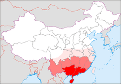
Medium Red: South China according to the 1945–1949 definition
Light Red: Southern China (A much broader area named Nanfang in Mandarin)
South China or Southern China (simplified Chinese: 华南; traditional Chinese: 華南; pinyin: huá nán) is a geographical and cultural region that covers the southernmost part of China. Its precise meaning varies with context.
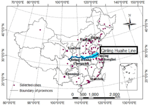
In normal parlance and geography, it refers to the region south of the Qinling Huaihe Line.[1]
Definitions
In the broadest sense, Southern China can denote the entire portion of the country south of the line demarcated by the Qin Mountains and Huai River. Between 1945 and 1949, the Republic of China defined Guizhou, Yunnan, Guangdong, Guangxi, Hainan, Fujian and Taiwan as the "Seven Provinces of South China" (simplified Chinese: 华南七省; traditional Chinese: 華南七省; pinyin: huá nán qī shěng). The term can also be used to denote the Lingnan region; but today, the phrase is generally used to refer only to Guangdong, Guangxi, Hainan, Hong Kong and Macau (historically also known as Liangguang). Defined as such, South China is also contained within South Central China.
Administrative divisions
| GB[2] | ISO №[3] | Province | Chinese Name | Capital | Population | Density | Area | Abbreviation/Symbol |
|---|---|---|---|---|---|---|---|---|
| GD | 44 | Guangdong Province | 广东省 Guǎngdōng Shěng |
Guangzhou | 104,303,132 | 579.46 | 180,000 | 粤 Yuè |
| GX | 45 | Guangxi Zhuang Autonomous Region | 广西壮族自治区 Guǎngxī Zhuàngzú Zìzhìqū |
Nanning | 46,026,629 | 195.02 | 236,000 | 桂 Guì |
| HI | 46 | Hainan Province | 海南省 Hǎinán Shěng |
Haikou | 8,671,518 | 255.04 | 34,000 | 琼 Qióng |
| HK | 91 | Hong Kong Special Administrative Region | 香港特别行政区 Hong Kong Special Administrative Region |
Hong Kong | 7,061,200 | 6,396.01 | 1,104 | 港 Kong |
| MC | 92 | Macau Special Administrative Region | 澳门特别行政区 Àomén Tèbié Xíngzhèngqū |
Macau | 552,300 | 19,044.82 | 29 | 澳 Ào |
Cities with urban area over one million in population
| # | City | Urban area[4] | District area[4] | City proper[4] | Prov. | Census date |
|---|---|---|---|---|---|---|
| 1 | Shenzhen | 10,358,381 | 10,358,381 | 10,358,381 | GD | 2010-11-01 |
| 2 | Guangzhou | 9,702,144 | 11,071,424 | 12,701,948 | GD | 2010-11-01 |
| 3 | Dongguan | 7,271,322 | 8,220,207 | 8,220,207 | GD | 2010-11-01 |
| 4 | Hong Kong[5] | 7,071,576 | 7,071,576 | 7,071,576 | HK | 2011-06-30 |
| 5 | Foshan | 6,771,895 | 7,197,394 | 7,197,394 | GD | 2010-11-01 |
| 6 | Shantou | 3,644,017 | 5,329,024 | 5,389,328 | GD | 2010-11-01 |
| 7 | Zhongshan | 2,740,994 | 3,121,275 | 3,121,275 | GD | 2010-11-01 |
| 8 | Nanning | 2,660,833 | 3,434,303 | 6,658,742 | GX | 2010-11-01 |
| 9 | Huizhou | 1,807,858 | 2,344,634 | 4,598,402 | GD | 2010-11-01 |
| 10 | Haikou | 1,517,410 | 2,046,170 | 2,046,170 | HI | 2010-11-01 |
| 11 | Jiangmen | 1,480,023 | 1,822,614 | 4,450,703 | GD | 2010-11-01 |
| 12 | Liuzhou | 1,410,712 | 1,436,599 | 3,758,704 | GX | 2010-11-01 |
| 13 | Zhuhai | 1,369,538 | 1,562,530 | 1,562,530 | GD | 2010-11-01 |
| 14 | Zhanjiang | 1,038,762 | 1,611,868 | 6,994,832 | GD | 2010-11-01 |
See also
- South Central China — includes South China and other "Central China" provincial-level subdivisions.
- List of regions of the People's Republic of China
References
- ↑ Shuangshuang, LI; Saini, YANG; Xianfeng, LIU (10 September 2015). "Spatiotemporal variability of extreme precipitation in north and south of the Qinling-Huaihe region and influencing factors during 1960-2013". The Chinese journal of geography. 34 (3): 354–363. Retrieved 25 May 2017.
- ↑ GB/T 2260 codes for the provinces of China
- ↑ ISO 3166-2:CN (ISO 3166-2 codes for the provinces of China)
- 1 2 3 国务院人口普查办公室、国家统计局人口和社会科技统计司编 (2012). 中国2010年人口普查分县资料. Beijing: 中国统计出版社 [China Statistics Press]. ISBN 978-7-5037-6659-6.
- ↑ 香港政府統計處編 [Hong Kong SAR Government Statistics Press] (2012). 香港2011年人口普查 - 主要報告. Hong Kong: Government Logistics Department.
External links
| Wikimedia Commons has media related to China Southeast. |
| Wikimedia Commons has media related to China South-Central. |