Tropical Storm Ewiniar (2018)
| Tropical storm (JMA scale) | |
|---|---|
| Tropical storm (SSHWS) | |
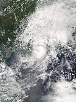 Tropical Storm Ewiniar shortly before landfall and peak strength on June 7 | |
| Formed | June 2, 2018 |
| Dissipated | June 13, 2018 |
| (Remnant low after June 9) | |
| Highest winds |
10-minute sustained: 75 km/h (45 mph) 1-minute sustained: 65 km/h (40 mph) |
| Lowest pressure | 998 hPa (mbar); 29.47 inHg |
| Fatalities | 15[1] |
| Damage | $573 million (2018 USD) |
| Areas affected | Philippines, Vietnam, South China, Taiwan, Ryukyu Islands |
| Part of the 2018 Pacific typhoon season | |
Tropical Storm Ewiniar was a weak tropical cyclone that affected South China in early June of 2018. The storm brought torrential rainfall and landslides over in the southern provinces. Ewiniar, as the fourth named storm of the 2018 Pacific typhoon season, firstly developed as a tropical depression just to the west of the Philippines on June 2. Maintaining its intensity for a few days in the South China Sea, the system moved north just near Hainan island where it intensified into a tropical storm on June 6. The storm made landfall shortly thereafter and rapidly weakened into a remnant low on June 9, before dissipating four days later.
The name was submitted by the Federated States of Micronesia and is the name of a Chuukese storm God.
Meteorological history

The Joint Typhoon Warning Center (JTWC) began to track a tropical disturbance that had develop about 139 mi (86 km) southeast of Puerto Princesa, Palawan.[2] At this point the system was located in a very favorable environment with relatively low wind shear between 5–10 knots and sea surface temperatures (SSTs) of over 31 °C (88 °F).[2] The JTWC then issued a Tropical Cyclone Formation Alert (TCFA) for the system the next day.[3] By 00:00 UTC on June 2, the Japan Meteorological Agency (JMA) classified the system as a tropical depression and began issuing advisories, estimating 10-minute sustained winds at about 55 km/h (35 mph).[4] Nine hours later, the JTWC followed suit and gave the identifier 05W.[5] Convection was only limited as it was wrapping into the system's low-level circulation center (LLCC).[6] By June 3, 05W entered an unfavorable environment with moderate to high wind shear, despite warm SSTs.[7] Due to this, deep convection was sheared away from the center which contributed to exposing and elongating the LLCC.[7]
05W remained as a weak tropical depression due to continuous high shear until on June 5, when the system started to re-organize with an improved and deepening convection while located in an area where shear had been reduced.[8] Continuous flaring convection along with weaker shear prompted the JTWC to upgrade 05W to a tropical storm by 21:00 UTC of the same day.[9] On 00:00 UTC of June 6, the JMA upgraded the system to a tropical storm too, receiving the name Ewiniar, the fourth named storm of the season.[10] Around that time, satellite imagery had depicted a growing central dense overcast where it was obscuring its LLCC.[11] According to the JTWC, however, by 09:00 UTC of that day, deep convection had diminished slightly which caused the storm to weaken back to a tropical depression.[12] By 06:00 UTC of June 7, the JMA had declared that Ewiniar had reached its peak intensity with 10-minute sustained winds of 75 km/h (45 mph) along with a minimum barometric pressure of 998 hPa (29.47 inHg).[13] In that same time, the JTWC re-upgraded Ewiniar back to a tropical storm as convection had deepened again, with a recognized 1-minute peak of only 65 km/h (40 mph).[14] Although six hours later, satellite imagery depicted that convective banding started to decay as Ewiniar neared the coast of southern China,[15] and this prompted the JTWC to issue their final advisory on Ewiniar on 21:00 UTC of the same day.[16] The JMA, though, tracked the system until 00:00 UTC on June 9, when the system rapidly degenerated into a remnant low over land.[17] The storm's remnant continued to persist, however, moving out to sea and crossing over Taiwan, before dissipating on June 13.
Preparations and impact
On June 6, rainfall amounts recorded in the island of Hainan were averaged about 100–200 mm (4–8 inches) with some reported of up to 300 mm (12 inches) in some areas.[18] On 12:40 p.m. local time (04:00 UTC) of June 7, the Hong Kong Observatory (HKO) issued "Typhoon Signal No.3", with winds warned and expected between 41–62 km/h (25–39 mph).[19] The Education Bureau had declared kindergarten and special-needs schools classes will be closed for the day due to the storm while some beaches were closed due to rough waves. Moreover the HKO had recorded a total 1-hour rainfall of 70 mm (0.4 inches) in the Sha Tin District.[19]
See also
References
- ↑ "Global Catastrophe Recap June 2018" (PDF). Retrieved July 15, 2018.
- 1 2 "{title}". Archived from the original on 2018-06-01. Retrieved 2018-06-01.
- ↑ "{title}". Archived from the original on 2018-06-01. Retrieved 2018-06-01.
- ↑ "RSMC Tropical Cyclone Advisory TD". Japan Meteorological Agency. June 2, 2018.
- ↑ "Tropical Depression 05W (Five) Warning Nr 001". June 2, 2018.
- ↑ "Prognostic Reasoning for Tropical Depression 05W (Five) Warning Nr 01". June 2, 2018.
- 1 2 "Prognostic Reasoning for Tropical Depression 05W (Five) Warning Nr 05". Joint Typhoon Warning Center. June 3, 2018.
- ↑ "Prognostic Reasoning for Tropical Depression 05W (Five) Warning Nr 12". Joint Typhoon Warning Center. June 5, 2018.
- ↑ "Prognostic Reasoning for Tropical Depression 05W (Five) Warning Nr 15". Joint Typhoon Warning Center. June 5, 2018.
- ↑ "RSMC Tropical Cyclone Advisory TS 1804 EWINIAR (1804) UPGRADED FROM TD". Japan Meteorological Agency. June 6, 2018.
- ↑ "Prognostic Reasoning for Tropical Depression 05W (Five) Warning Nr 16". Joint Typhoon Warning Center. June 6, 2018.
- ↑ "Prognostic Reasoning for Tropical Depression 05W (Five) Warning Nr 17". Joint Typhoon Warning Center. June 6, 2018.
- ↑ "RSMC Tropical Cyclone Advisory TS 1804 EWINIAR (1804)". Japan Meteorological Agency. June 7, 2018.
- ↑ "Prognostic Reasoning for Tropical Storm 05W (Ewiniar) Warning Nr 11". Joint Typhoon Warning Center. June 7, 2018.
- ↑ "Prognostic Reasoning for Tropical Storm 05W (Ewiniar) Warning Nr 22". Joint Typhoon Warning Center. June 7, 2018.
- ↑ "Tropical Storm 05W (Ewiniar) Warning Nr 23". Joint Typhoon Warning Center. June 7, 2018.
- ↑ "RSMC Tropical Cyclone Advisory TD DOWNGRADED FROM TS 1804 EWINIAR (1804)". Japan Meteorological Agency. June 9, 2018.
- ↑ "Tropical Storm Ewiniar to bring flooding rain to southern China". AccuWeather. June 6, 2018.
- 1 2 "Typhoon signal No 3 issued as tropical storm Ewiniar brings floods to Hong Kong". South China Morning Post. June 7, 2018.
External links
| Wikimedia Commons has media related to Tropical Storm Ewiniar (2018). |
- JMA General Information on Tropical Storm Ewiniar (1804) from Digital Typhoon
- JMA Best Track Data (Text)
- 05W.EWINIAR from the U.S. Naval Research Laboratory
Tropical cyclones of the 2018 Pacific typhoon season | ||||||||||||||||||||||||||||||||||||||||||||||||||||||||||||||||||||||||||||||||||
|---|---|---|---|---|---|---|---|---|---|---|---|---|---|---|---|---|---|---|---|---|---|---|---|---|---|---|---|---|---|---|---|---|---|---|---|---|---|---|---|---|---|---|---|---|---|---|---|---|---|---|---|---|---|---|---|---|---|---|---|---|---|---|---|---|---|---|---|---|---|---|---|---|---|---|---|---|---|---|---|---|---|---|
 |
| |||||||||||||||||||||||||||||||||||||||||||||||||||||||||||||||||||||||||||||||||
| ||||||||||||||||||||||||||||||||||||||||||||||||||||||||||||||||||||||||||||||||||