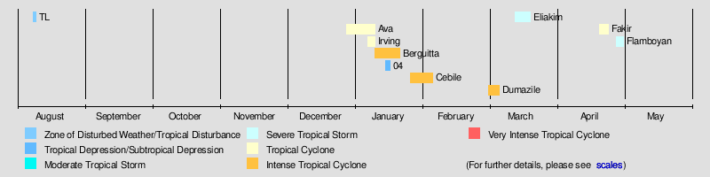
2017–18 South-West Indian Ocean cyclone season
| 2017–18 South-West Indian Ocean cyclone season | |
|---|---|
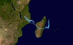
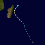
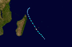
 Season summary map | |
| Seasonal boundaries | |
| First system formed | December 27, 2017 |
| Last system dissipated | May 1, 2018 |
| Strongest storm | |
| Name | Berguitta[nb 1] |
| • Maximum winds |
165 km/h (105 mph) (10-minute sustained) |
| • Lowest pressure | 940 hPa (mbar) |
| Seasonal statistics | |
| Total disturbances | 9 official, 1 unofficial |
| Total depressions | 9 |
| Total storms | 8 |
| Tropical cyclones | 6 |
| Intense tropical cyclones | 3 |
| Very intense tropical cyclones | 0 |
| Total fatalities | 108 total |
| Total damage | $38.2 million (2018 USD) |
| Related articles | |
The 2017–18 South-West Indian Ocean cyclone season was a below-average season that produced only 8 tropical storms, of which only 5 became tropical cyclones. It was an event in the annual cycle of tropical cyclone and subtropical cyclone formation. It officially began on November 15, 2017, and officially ended on May 15, 2018, in Mauritius and the Seychelles. For the rest of the basin, the season ended on April 30, 2018. These dates conventionally delimit the period of each year when most tropical and subtropical cyclones form in the basin, which is west of 90°E and south of the Equator. Tropical and subtropical cyclones in this basin are monitored by the Regional Specialised Meteorological Centre in La Réunion.
Seasonal summary
Systems
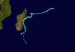
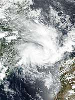
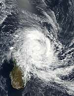
Tropical Cyclone Ava
| Tropical cyclone (MFR) | |
| Category 2 tropical cyclone (SSHWS) | |
  | |
| Duration | December 27 – January 9 |
|---|---|
| Peak intensity | 155 km/h (100 mph) (10-min) 965 hPa (mbar) |
The cyclone's powerful winds, estimated up to 190 km/h (120 mph), caused extensive damage in and around Toamasina.[1] Hundreds of power poles were snapped across Toamasina; Jirama estimated repairs to be in excess of 10 billion Ariary (US$3.1 million).[2] Heavy rains triggered flash floods in Tamatave and Antananarivo. Throughout Madagascar, at least 51 people died while 22 more were listed as missing.[1] Approximately 161,000 people suffered direct impacts from the cyclone,[3] with 54,000 people left homeless.[1]
Tropical Cyclone Irving
| Tropical cyclone (MFR) | |
| Category 2 tropical cyclone (SSHWS) | |
  | |
| Duration | January 6 (Entered basin) – January 9 |
|---|---|
| Peak intensity | 150 km/h (90 mph) (10-min) 964 hPa (mbar) |
Irving was named by the Bureau of Meteorology of Australia on January 6 and crossed over into to the South-West Indian Ocean basin a few hours later.
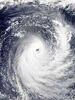
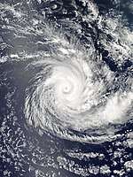
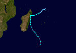
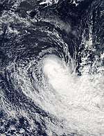
Intense Tropical Cyclone Berguitta
| Intense tropical cyclone (MFR) | |
| Category 3 tropical cyclone (SSHWS) | |
  | |
| Duration | January 9 – January 20 |
|---|---|
| Peak intensity | 165 km/h (105 mph) (10-min) 940 hPa (mbar) |
Tropical Depression 04
| Tropical depression (MFR) | |
  | |
| Duration | January 14 – January 16 |
|---|---|
| Peak intensity | 55 km/h (35 mph) (10-min) 999 hPa (mbar) |
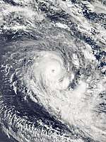
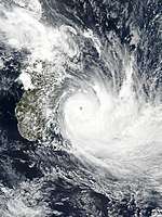
Intense Tropical Cyclone Cebile
| Intense tropical cyclone (MFR) | |
| Category 4 tropical cyclone (SSHWS) | |
  | |
| Duration | January 25 – February 4 |
|---|---|
| Peak intensity | 185 km/h (115 mph) (10-min) 944 hPa (mbar) |
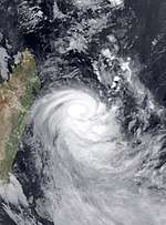
Intense Tropical Cyclone Dumazile
| Intense tropical cyclone (MFR) | |
| Category 3 tropical cyclone (SSHWS) | |
  | |
| Duration | March 1 – March 6 |
|---|---|
| Peak intensity | 165 km/h (105 mph) (10-min) 945 hPa (mbar) |
Dumazile formed from a low on March 2. After formation, Dumazile began rounding a subtropical ridge to the east. Dumazile brought heavy rain to Madagascar.[4] Dumazile then began weakening as a result of increasing shear wind from a low pressure system to the southwest and became post-tropical early on March 7.
Severe Tropical Storm Eliakim
| Severe tropical storm (MFR) | |
| Tropical storm (SSHWS) | |
  | |
| Duration | March 13 – March 20 |
|---|---|
| Peak intensity | 110 km/h (70 mph) (10-min) 980 hPa (mbar) |
At least 20 people were killed and approximately 15,000 people were affected in Madagascar.[5][6] The eastern coastal districts were the hardest hit. More than 260 homes were destroyed and a further 630 were flooded.[6]
Tropical Cyclone Fakir
| Tropical cyclone (MFR) | |
| Category 1 tropical cyclone (SSHWS) | |
  | |
| Duration | April 20 – April 25 |
|---|---|
| Peak intensity | 130 km/h (80 mph) (10-min) 975 hPa (mbar) |
Severe Tropical Storm Flamboyan
| Severe tropical storm (MFR) | |
| Category 1 tropical cyclone (SSHWS) | |
  | |
| Duration | April 28 (Entered basin) – May 1 |
|---|---|
| Peak intensity | 110 km/h (70 mph) (10-min) 983 hPa (mbar) |
Late on April 28, Flamboyan entered the South-West Indian Ocean basin. Flamboyan retained its name after moving into the basin, becoming the first moderate tropical storm in the South-West Indian Ocean basin to be named by TCWC Jakarta in history.[nb 2] On April 29, Flamboyan intensified into a severe tropical storm.
Other systems
A low-pressure system, classified as a tropical low by the Australian Bureau of Meteorology,[7] moved west-southwest across the 90th meridian east into the Southwest Indian Ocean basin on August 8.[8] At 10:00 UTC the following day, Météo-France Réunion upgraded the low-pressure system to a zone of disturbed weather, with sustained winds of up to 55 km/h (35 mph) being detected on the southern side of the circulation by scatterometer.[9] At this time, the disturbance was located approximately 2,375 km (1,475 mi) west of Jakarta, Indonesia.[9] Météo-France noted that the revival of convective activity in the basin was likely due to the interaction between an eastward-moving Kelvin wave and a westward-moving Rossby wave.[9]
Storm names
Within the South-West Indian Ocean, tropical depressions and subtropical depressions that are judged to have 10-minute sustained wind speeds of 65 km/h (40 mph) by the Regional Specialized Meteorological Center on La Réunion Island, France (RSMC La Réunion) are usually assigned a name. However, it is the Sub-Regional Tropical Cyclone Advisory Centers in Mauritius and Madagascar who name the systems. The Sub-Regional Tropical Cyclone Advisory Center in Mauritius names a storm should it intensify into a moderate tropical storm between 55°E and 90°E. If instead a cyclone intensifies into a moderate tropical storm between 30°E and 55°E then the Sub-Regional Tropical Cyclone Advisory Center in Madagascar assigns the appropriate name to the storm. Beginning from the 2016–17 season, name lists within the South-West Indian Ocean will be rotated on a triennial basis. Storm names are only used once, so any storm name used this year will be removed from rotation and replaced with a new name for the 2020–21 season. The unused names are expected to be reused in the list for the 2020–21 season.[10]
|
|
|
Seasonal effects
This table lists all of the tropical cyclones and subtropical cyclones that were monitored during the 2017–2018 South-West Indian Ocean cyclone season. Information on their intensity, duration, name, areas affected, primarily comes from RSMC La Réunion. Death and damage reports come from either press reports or the relevant national disaster management agency while the damage totals are given in 2017 or 2018 USD.
| Name | Dates active | Peak classification | Sustained wind speeds |
Pressure | Areas affected | Damage (USD) |
Deaths | Refs |
|---|---|---|---|---|---|---|---|---|
| Ava | December 27 – January 9 | Tropical cyclone | 155 km/h (100 mph) | 965 hPa (28.50 inHg) | Madagascar | $3.1 million | 73 | [11][12][13] |
| Irving | January 6 – 9 | Tropical cyclone | 150 km/h (90 mph) | 964 hPa (28.47 inHg) | None | None | None | |
| Berguitta | January 9 – 20 | Intense tropical cyclone | 165 km/h (105 mph) | 940 hPa (27.76 inHg) | Mauritius, Réunion | $12 million | 1 | [14][15] |
| 04 | January 14 – 16 | Tropical depression | 55 km/h (35 mph) | 999 hPa (29.50 inHg) | Madagascar, Mozambique | $5.1 million | 11 | [13] |
| Cebile | January 25 – February 4 | Intense tropical cyclone | 185 km/h (115 mph) | 944 hPa (27.88 inHg) | None | None | None | |
| Dumazile | March 1 – 6 | Intense tropical cyclone | 165 km/h (105 mph) | 945 hPa (27.91 inHg) | Madagascar, Réunion, Mauritius | None | None | |
| Eliakim | March 13 – 20 | Severe tropical storm | 110 km/h (70 mph) | 980 hPa (28.94 inHg) | Madagascar | Unknown | 21 | [16][17] |
| Fakir | April 20 – 24 | Tropical cyclone | 130 km/h (80 mph) | 975 hPa (28.79 inHg) | Madagascar, Réunion, Mauritius | $18 million | 2 | [18][19] |
| Flamboyan | April 28 – May 1 | Severe tropical storm | 110 km/h (70 mph) | 983 hPa (29.03 inHg) | None | None | None | |
| Season aggregates | ||||||||
| 9 systems | December 27 – May 1 | 185 km/h (115 mph) | 940 hPa (27.76 inHg) | $38.2 million | 108 | |||
See also
- Tropical cyclones in 2018
- List of Southern Hemisphere cyclone seasons
- Atlantic hurricane seasons: 2017, 2018
- Pacific hurricane seasons: 2017, 2018
- Pacific typhoon seasons: 2017, 2018
- North Indian Ocean cyclone seasons: 2017, 2018
- 2017–18 Australian region cyclone season
- 2017–18 South Pacific cyclone season
- South Atlantic tropical cyclone
Footnotes
References
- 1 2 3 "Le bilan du cyclone Ava à Madagascar s'élève à 51 morts". Le Monde (in French). Agence France-Presse and Reuters. January 15, 2018. Retrieved February 1, 2018.
- ↑ Ny Aina Rahaga (January 23, 2018). "10 milliards d'Ariary pour le rétablissement de l'électricité après le cyclone AVA" (in French). Madagascar Tribune. Retrieved February 1, 2018.
- ↑ "Madagascar : le cyclone Ava a fait 51 morts et 22 disparus". Le Parisien (in French). January 15, 2018. Retrieved February 1, 2018.
- ↑ "Madagascar – Heavy Rain Reported as Tropical Cyclone Dumazile Moves South".
- ↑ "Tropical storm Eliakim kills 17 in Madagascar: authorities". Reuters. March 19, 2018. Archived from the original on 2018-03-19. Retrieved March 19, 2018.
- 1 2 "17 die in Madagascar tropical storm". Daily Nation. March 19, 2018. Retrieved March 19, 2018.
- ↑ "WebCite query result". www.webcitation.org. Retrieved 2017-08-08.
- ↑ "WebCite query result". www.webcitation.org. Retrieved 2017-08-09.
- 1 2 3 "ZCIT Bulletin for August 9 2017" (PDF).
- ↑ Regional Association I Tropical Cyclone Committee (2016). "Tropical Cyclone Operational Plan for the South-West Indian Ocean" (PDF). World Meteorological Organization. Retrieved 2016-10-05.
- ↑ "Madagascar cyclone death toll rises to 51, with 54,000 people displaced". Hindustan Times. 15 January 2018. Retrieved 15 January 2018.
- ↑ Ny Aina Rahaga (January 23, 2018). "10 milliards d'Ariary pour le rétablissement de l'électricité après le cyclone AVA" (in French). Madagascar Tribune. Retrieved February 1, 2018.
- 1 2 "Global Catastrophe Recap January 2018" (PDF). thoughtleadership.aonbenfield.com. Aon Benfield. Retrieved February 10, 2018.
- ↑ "Tempête tropicale intense : quel impact et quel coût sur les secteurs affectés ?". Le Défi Média. 19 January 2018. Retrieved 19 January 2018.
- ↑ "Tropical Cyclone Berguitta PATH LIVE: Storm track LOOMS on La Reunion as Mauritius BLASTED". Express. 18 January 2018. Retrieved 19 January 2018.
- ↑ "Dozens Deaths Confirm Malagasy's Fear of Cyclone". Prensa Latina. 20 March 2018. Retrieved 21 March 2018.
- ↑ "Global Catastrophe Recap March 2018" (PDF). thoughtleadership.aonbenfield.com. Aon Benfield. Retrieved April 23, 2018.
- ↑ "Tropical Storm Fakir turns deadly after unleashing destructive winds, mudslides on La Reunion". AccuWeather. 26 April 2018. Retrieved 27 April 2018.
- ↑ "Global Catastrophe Recap April 2018" (PDF). thoughtleadership.aonbenfield.com. Aon Benfield. Retrieved May 17, 2018.
External links
| Wikimedia Commons has media related to 2017-18 South-West Indian Ocean cyclone season. |