2018 North Indian Ocean cyclone season
| 2018 North Indian Ocean cyclone season | |
|---|---|
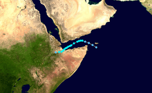
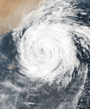
 Season summary map | |
| Seasonal boundaries | |
| First system formed | March 13, 2018 |
| Last system dissipated | Season ongoing |
| Strongest storm | |
| Name | Mekunu |
| • Maximum winds |
175 km/h (110 mph) (3-minute sustained) |
| • Lowest pressure | 960 hPa (mbar) |
| Seasonal statistics | |
| Depressions | 12 |
| Deep depressions | 7 |
| Cyclonic storms | 5 |
| Severe cyclonic storms | 3 |
| Very severe cyclonic storms | 3 |
| Super cyclonic storms | 0 |
| Total fatalities | 297 total |
| Total damage | $980 million (2018 USD) |
| Related articles | |
The 2018 North Indian Ocean cyclone season is an ongoing event in the annual cycle of tropical cyclone formation. The North Indian Ocean cyclone season has no official bounds, but cyclones tend to form between April and December, with the peak from May to November. These dates conventionally delimit the period of each year when most tropical cyclones form in the northern Indian Ocean.
The scope of this article is limited to the Indian Ocean in the Northern Hemisphere, east of the Horn of Africa and west of the Malay Peninsula. There are two main seas in the North Indian Ocean — the Arabian Sea to the west of the Indian subcontinent, abbreviated ARB by the India Meteorological Department (IMD); and the Bay of Bengal to the east, abbreviated BOB by the IMD.
The official Regional Specialized Meteorological Centre in this basin is the India Meteorological Department (IMD), while the Joint Typhoon Warning Center (JTWC) and the National Meteorological Center of CMA (NMC) unofficially release full advisories. On average, three to four cyclonic storms form in this basin every season.[1][2]
Season summary

Systems
Depression ARB 01
| Depression (IMD) | |
  | |
| Duration | March 13 – March 15 |
|---|---|
| Peak intensity | 45 km/h (30 mph) (3-min) 1006 hPa (mbar) |
On March 10, a low pressure area formed in the Indian Ocean, near the equator.[3] It became better defined on March 13 and concentrated into a depression in the extreme southeast Arabian Sea.[4][5] The depression moved north-northwestwards and weakened into a well-marked low pressure area over Lakshadweep, early on March 15.[3]
An unusual feature of the depression was that it was formed very close to the equator, at a latitude of 1.7°N.[6] Though the equatorial seas heat up more rapidly, the spin required for tropical cyclone formation is weak near the equator.[6] The coastal port city of Tuticorin in Tamil Nadu, very close to the southern tip, received 200 mm of rain, its highest daily precipitation ever recorded, on March 13. Minicoy Island in Lakshadweep received 177 mm of rain from the system.[6]
Cyclonic Storm Sagar
| Cyclonic storm (IMD) | |
| Tropical storm (SSHWS) | |
  | |
| Duration | May 16 – May 20 |
|---|---|
| Peak intensity | 85 km/h (50 mph) (3-min) 994 hPa (mbar) |
On May 16, a low-pressure area moved into the Gulf of Aden and developed into a depression, receiving the designation ARB 02. [7] On the next day, the system strengthened into a cyclonic storm and was given the name Sagar.[8] On May 18, the system strengthened and organized into a small and compact cyclone, with a rough eye feature.[9] Under the influence of a ridge anchored over the Arabian Sea, the cyclone moved southwestward, and made landfall on Somalia between 1:30 PM and 2:30 PM (IST) on May 19.[10]
The northern part of Sagar brought heavy rain and some minor flooding to coastal towns of Yemen.[11] Yemen's temporary capital Aden was hit by strong winds as tropical cyclone Sagar approached, prompting authorities to a call on residents to evacuate areas near the shore in the southern port city.[12] Sagar brought heavy rainfall to coastal areas in Yemen's Hadramawt and Mahra provinces and Socotra Island. Strong winds in Hadramawt and Mahra damaged homes and led to numerous power outages,[12] and the deaths of 79 people, including 23 from a landslide in Ethiopia.[13][14] Prior to Sagar becoming a cyclonic storm, distant warning signal number 2 had been hoisted across major ports along the coasts of Gujarat, although the system was forecasted to not affect India.
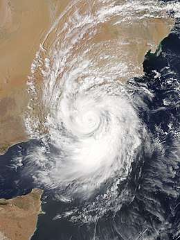
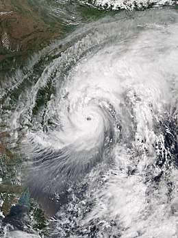
Extremely Severe Cyclonic Storm Mekunu
| Extremely severe cyclonic storm (IMD) | |
| Category 3 tropical cyclone (SSHWS) | |
  | |
| Duration | May 21 – May 27 |
|---|---|
| Peak intensity | 175 km/h (110 mph) (3-min) 960 hPa (mbar) |
An area of convection developed to the northwest of the Maldives on May 18.[15] Over the next two days, it became better organized and the IMD reported that it had developed into a low pressure area on May 20, giving it the identifier ARB 03.[16] The system slowly drifted northwestwards into favorable environment for tropical cyclogenesis and developed good outflow.[17] The JTWC issued a TCFA on May 21 after convective bands began to wrap into the broad low-level circulation center (LLCC).[18] Around the same time, the IMD had announced that the system intensified into a depression.[19] Over the next 24 hours, the depression continued to drift further northwestwards into warm waters and faced low vertical wind shear. As a result, it continued to intensify and the JTWC began tracking it as a tropical storm.[20] Subsequently, the IMD upgraded it to a deep depression[21] and Cyclonic Storm Mekunu later the same day.[22] Multi-spectral satellite imagery revealed that Mekunu had developed an eye as early as May 23,[23] at which time the IMD upgraded it to a severe cyclonic storm.[24] Benefiting from favorable environmental conditions, the cyclone became more symmetric,[25] intensifying into a very severe cyclonic storm six hours later.[26] The cyclone continued to track northwestward under the influence of a subtropical ridge.[27] On May 25, it reached its peak intensity as an extremely severe cyclonic storm, with the JTWC estimating peak 1-minute sustained winds of 185 km/h (115 mph), equivalent to a Category 3 storm on the Saffir-Simpson scale.
Under the influence of Mekunu, Socotra received widespread rainfall leading to flash flooding and downed power lines. At least 40 people were initially reported to be missing after two ships were capsized off Socotra.[28] Mekunu made landfall on the Omani coast near the city of Salalah at peak intensity. Gusts of 67 mph (108 km/h) were recorded at the Salalah Airport before the landfall while areas in the Salalah recorded rainfall of 194 mm (7.6 in).[29] As of 31 May, at least 30 people have died in Oman and Yemen due to Mekunu, including 20 on Socotra, four in Yemen,[30] and six in Oman.[31] Insurance claims in Oman reached ﷼73.9 million (OMR, $190 million USD).[32][33]
Deep Depression BOB 01
| Deep depression (IMD) | |
| Tropical storm (SSHWS) | |
  | |
| Duration | May 29 – May 30 |
|---|---|
| Peak intensity | 55 km/h (35 mph) (3-min) 990 hPa (mbar) |
A low pressure area developed in the northeast Bay of Bengal on May 28. It was classified as a well marked low by the IMD on May 29. Due to favorable conditions, the system intensified into a depression on the same day and was given the designation BOB 01 by the IMD. The system further intensified into a deep depression on the same day and made landfall on the coast of Myanmar, near Kyaukpyu. The system brought heavy rains to Myanmar and Bangladesh, with minor flooding reported at some locations.
Myanmar's Meteorology and Hydrology Department issued a red-code emergency alert warning on Tuesday prior to the landfall.[34] Strong wind, coupled with torrential rain, destroyed over 500 houses in Shwe Pyi Tha township in Myanmar's Yangon region. The strong wind knocked down trees and destroyed many houses, cutting power supply in the township.[35] Temporary shelters were set up to accommodate the homeless victims with aid provided. On the same day, heavy rain and strong wind also blew off tree branches in Hmawbi, Dagon Myothit-north and other townships.[35] The local authorities have suspended the waterway of Angumaw-Sittway for three days.[35]
Depression BOB 02
| Depression (IMD) | |
  | |
| Duration | June 10 – June 10 |
|---|---|
| Peak intensity | 45 km/h (30 mph) (3-min) 989 hPa (mbar) |
A low-pressure area developed in the Bay of Bengal on June 9. Owing to favorable conditions, the system intensified into a depression on June 10; thus, the IMD classified it as Depression BOB 02. Late on the same day, the system crossed the coast of Bangladesh near Feni, before subsequently weakening into a well-marked low-pressure area.
The storm brought heavy rain to the states of Odisha and West Bengal, and some parts of Bangladesh received extremely heavy rain, as it helped in the advancement of monsoon. Squally weather affected the maritime ports, North Bay, and adjoining coastal areas of Bangladesh. The maritime ports of Chattogram, Cox’s Bazar, Mongla and Payra had been advised to keep hoisted local cautionary signal No. 3. In Patenga, 150 mm of rain was recorded within the previous two days.[36]
Depression BOB 03
| Depression (IMD) | |
  | |
| Duration | July 21 – July 23 |
|---|---|
| Peak intensity | 45 km/h (30 mph) (3-min) 989 hPa (mbar) |
A low-pressure area formed in the northwest Bay of Bengal, near the Odisha and West Bengal coast on July 20. On July 21, the system organized into a depression and made landfall in between Chandabali and Digha border near Balasore in the same evening. The system triggered monsoon rains in several parts of Odisha, which lead to heavy rainfall and minor flooding in several districts of Odisha. Waterlogging was seen in many areas of the twin cities of Bhubaneswar-Cuttack, as both the cities experienced more than 200 mm of rain. Burla in Odisha received 627 mm in 24 hours while Sambalpur in Odisha received 567 mm of rain in 24 hours on July 22, an all-time record for the city in July. Hirakud Dam received 400 mm during the same 24 hour period. The storm maintained the intensity of a depression until it had moved nearly 400 km inland, before weakening into a well-marked low-pressure area near southeast Uttar Pradesh, on July 23. The system also triggered rainfall over West Bengal. Halisahar recorded 106 mm of rain in 3 days.
The system continued to move west-northwestward and reached western Uttar Pradesh and the Indian capital of New Delhi by July 26, causing widespread rain over the region. Meerut in Uttar Pradesh received 226 mm of rain in 24 hours, on July 27, while Delhi received 83 mm over a period of 5 days, beginning on July 26. At least 69 people were killed in Uttar Pradesh, due to heavy rains from the storm as a low-pressure area.[37][38] The river Yamuna crossed the danger level of 204.83 meters in the national capital of Delhi on July 27, and reached to 205.5 meters by July 29, nearly 70 cm above the danger level, prompting the evacuation of more than 1,500 people in Delhi.[39]
Depression BOB 04
| Depression (IMD) | |
  | |
| Duration | August 7 – August 8 |
|---|---|
| Peak intensity | 45 km/h (30 mph) (3-min) 992 hPa (mbar) |
On August 7, a depression formed over the northwestern Bay of Bengal, with the IMD assigning it the designation BOB 04. The system dropped heavy rainfall over Odisha and the western parts of West Bengal. Bankura in West Bengal received extremely heavy rainfall amounts of 404 mm within 24 hours, leading to flooding. At least 1 person was killed, due to the heavy rainfall. The city of Bankura was heavily affected, with many houses destroyed. Additionally, Puri in Odisha saw 394 mm of rainfall, while Bhubaneshwar saw 178 mm of rainfall. On August 8, the depression weakened into a low-pressure area and moved over the north Chhattisgarh neighborhood.
Depression BOB 05
| Depression (IMD) | |
  | |
| Duration | August 15 – August 17 |
|---|---|
| Peak intensity | 45 km/h (30 mph) (3-min) 994 hPa (mbar) |
On August 15, a depression formed in the Bay of Bengal, just off the south Odisha coast, receiving the designation BOB 05. The storm moved westward, soon making landfall on Odisha, dropping heavy rainfall over the region. The storm triggered floods across Odisha during this time. The system weakened and continued to move west-northwestward over Maharashtra and Gujarat, leading to widespread rainfall over the region. Early on August 17, the depression weakened into a well-marked low-pressure area over southwest Madhya Pradesh, near the west coast of India.
At least 2 deaths were reported from the Kalahandi and Koraput Districts, due to heavy rain. The depression also caused heavy monsoonal rainfall over Chhattisgarh, Maharashtra, and Kerala, which killed 69 people. BOB 05 also increased rainfall activity over Mumbai. Yeotmal in Maharashtra received 176 mm of rainfall, followed by Mahabaleshwar, which recorded 163 mm. Additionally, Aurangabad recorded 157 mm of rain, while Jalna received 136 mm of rain. Khandwa in Madhya Pradesh also recorded heavy rainfall, with amounts near 173 mm. In Gujarat, Ahmedabad recorded 142 mm of rain, which also led to minor flooding.
Deep Depression BOB 06
| Deep depression (IMD) | |
  | |
| Duration | September 6 – September 7 |
|---|---|
| Peak intensity | 55 km/h (35 mph) (3-min) 990 hPa (mbar) |
On September 6, a depression developed in the northern Bay of Bengal, off the coast of Odisha and West Bengal, receiving the designation BOB 06. It intensified into a deep depression on the same day and produced extremely heavy rainfall over Odisha, along with strong winds. The depression moved on a westward course, soon making landfall near Odisha coast. The depression quickly weakened after landfall, degenerating into a well-marked low-pressure area on September 7.
Kendrapara in Odisha recorded 271.7 mm of rain, Jagatsinghpur received 236.1 mm, Jajpur received 137 mm, Cuttack received 113.5 mm, and Bhadrak recorded 105.7 mm of rain. The Ersama block of Jagatsinghpur saw the highest rainfall amount of 450 mm rain within 24 hours.
"All major rivers were flowing below the danger level. Only Baitarani River was flowing above the warning level at Akhuapada. There had been waterlogging in Jagatsinghpur, Kendrapara and Jajpur districts which have received extremely heavy rainfall,” stated SRC Bishnupada Sethi. Waterlogging was also reported on the campus of Sun Temple in Konark. The Archaeological Survey of India deployed four high-powered motors to pump out the water from the campus.
The Cuttack district administration ordered closure of educational institutes in view of heavy rain on Thursday. A 52-year-old man was killed in a wall collapse at Balisukri village, under Kishorenagar police station in the district, following persistent rainfall from the deep depression, while it was situated over the northwest Bay of Bengal.
The depression itself is a rarity, forming during the first week of the monsoon withdrawal month of September, accompanied by high winds and heavy rain initially over East India. Squally winds with speeds reaching 50 km/h and gusting to 60 km/h prevailed along and off the Bengal and Odisha coasts, and sustained winds of 40 km/h and gusts to 50 km/h were recorded over Odisha, Bengal, and Jharkhand.
Cyclonic Storm Daye
| Cyclonic storm (IMD) | |
| Tropical storm (SSHWS) | |
  | |
| Duration | September 19 – September 22 |
|---|---|
| Peak intensity | 65 km/h (40 mph) (3-min) 992 hPa (mbar) |
On September 19, a depression formed over the east central Bay of Bengal, receiving the designation BOB 07. Soon afterward, the JTWC has issued a Tropical Cyclone Formation Alert (TCFA). Early on September 20, the storm intensified into a deep depression over the west central Bay of Bengal. The system intensified further, becoming Cyclonic Storm Daye later that day, while situated over the northwestern Bay of Bengal. Early on September 21, Daye made landfall on south Odisha, also impacting the adjoining north Andhra Pradesh coast near Gopalpur, during the morning, local time, resulting in heavy rains and strong winds of 65 to 75 km/h in various districts in the regions. Upon its landfall, Daye brought heavy to very heavy rainfall in various districts of Odisha. Following landfall, Daye weakened into a depression. Over the next two days, Daye continued moving westward, while dropping heavy amounts of rain across India. On September 22, Daye weakened into a well-marked low, with the IMD issuing its final advisory on the system.
Prior to the cyclone's landfall at midnight, local time, on September 21, the government of Odisha deployed emergency teams in Malkangiri, with more teams on standby in Rayagada, Gajapati, and Puri. One NDRF team had each been deployed in Kalahandi, Rayagada, Gajapati, Puri, Nayagarh, and Kandhamal districts, with 17 boats and other emergency equipment. Local cautionary Signal Number LC-III had been kept hoisted at all ports of Odisha when the cyclone was a deep depression.
Malkangiri was worst affected, with many houses submerged. Several parts of outer Malkangiri city and rural areas of the district reportedly received heavy cyclonic rains. Several houses had submerged into water, leaving many people homeless. According to reports, a maximum rainfall total of 284 mm was recorded at Malkangiri by the India Meteorological department (IMD). In Balasore District, the water was flowing above the danger level in the Jalaka River. Water level increased in the Kolab Dam and two gates were opened.
The outer rainbands of the storm dropped extremely heavy rain in the southern parts of West Bengal. Digha recorded 229 mm of rain, Contai received 331 mm of rain, Diamond Harbour recorded 66 mm of rain, Midnapore received 79 mm of rain, and Halisahar recorded 51 mm of rain. Torrential rains and flash floods were also reported in Himachal Pradesh, Uttarakhand, and Punjab, resulting in at least 25 deaths. The floodgates of the famous Sukhna Lake in Chandigarh were opened, for the first time in 10 years.
As Daye weakened into a low-pressure area, the storm interacted with another western disturbance to the north, leading to widespread rainfall in the northern Himalayas and the plains to the south, from September 22–24. Delhi received heavy rains between September 22–24 totaling 58.6 mm, resulting in severe waterlogging. High temperatures in Delhi were up to 6 Degrees Celsius below normal. Amritsar in Punjab received large amounts of rainfall ending early on September 24, with a total of 203.0 mm, while Karnal in Haryana received one of its highest 24-hour rainfall totals in September, with a total of 142.0 mm.
Very Severe Cyclonic Storm Luban
| |||
|---|---|---|---|
| |||
| As of: | 23:30 IST (18:00 UTC) October 13 | ||
| Location: |
15°00′N 53°42′E / 15.0°N 53.7°E About 220 km SSW of Salalah About 260 km N of Socotra Island About 210 km ESE of Al-Ghaidah About 480 km ENE of Riyan | ||
| Sustained winds: |
85 km/h (50 mph) (3-min mean) 75 km/h (45 mph) (1-min mean) gusting to 100 km/h (65 mph) | ||
| Pressure: | 994 hPa (mbar; 29.35 inHg) | ||
| Movement: | WNW at 6 kn (11 km/h; 6.9 mph) | ||
| |||

On October 6, a depression formed in the Arabian Sea, with the IMD assigning the storm the identifier ARB 04. On the next day, ARB 04 strengthened into a Deep Depression, while slowly moving westward. Early on October 8, the system intensified into Cyclonic Storm Luban, while turning to the northwest. Between 05:30 and 06:00 UTC October 14, Luban made landfall just north of Nishtun, Yemen, with winds of 45 mph (75 km/h)
On October 9, The coastal city of Karachi, Pakistan experienced a foul smell, as phytoplankton washed ashore.[40]
Current storm information
As of 23:30 IST (18:00 UTC) October 13, Cyclonic Storm Luban is located near 15°00′N 53°42′E / 15.0°N 53.7°E, about 220 km (140 mi) south-southwest of Salalah, Oman, and about 260 km (160 mi) north of Socotra Island, Yemen, and about 210 km (130 mi) east-southeast of Al-Ghaidah, Yemen, and about 480 km (300 mi) east-northeast of Riyan, Mukalla. Maximum 3-minute sustained wind speeds are about 85 km/h (50 mph), while 1-minute sustained wind speeds are about 75 km/h (45 mph); gusts are reaching 100 km/h (65 mph). Minimum central pressure is estimated at 994 hPa (29.35 inHg). The Dvorak T-number of the storm is T2.5 / CI3.0, and it is moving west-northwestwards at 6 kn (11 km/h; 6.9 mph).
For more latest information, see:
Very Severe Cyclonic Storm Titli
| Very severe cyclonic storm (IMD) | |
| Category 2 tropical cyclone (SSHWS) | |
  | |
| Duration | October 8 – October 12 |
|---|---|
| Peak intensity | 150 km/h (90 mph) (3-min) 970 hPa (mbar) |
Early on October 8, a low-pressure area organized into a depression in the east central Bay of Bengal, with the IMD assigning the system the identifier BOB 08. Later on the same day, the system strengthened into a Deep Depression. Between 4:30 a.m. and 5:30 a.m. IST October 11 (23:00–00:00 UTC October 10–11), Titli made landfall near Palasa, Andhra Pradesh, at peak intensity. The storm in total killed at least 15 and left a couple of others missing, due to heavy flooding and landslides.[41]
Storm names
Within this basin, a tropical cyclone is assigned a name when it is judged to have reached Cyclonic Storm intensity with winds of 65 km/h (40 mph). The names were selected by members of the ESCAP/WMO panel on Tropical Cyclones between 2000 and May 2004, before the Regional Specialized Meteorological Center in New Delhi started to assign names in September 2004. There is no retirement of tropical cyclone names in this basin as the list of names is only scheduled to be used once before a new list of names is drawn up. Should a named tropical cyclone move into the basin from the Western Pacific, then it will retain its original name. The next six available names from the List of North Indian Ocean storm names are below.
|
|
Season effects
This is a table of all storms in the 2018 North Indian Ocean cyclone season. It mentions all of the season's storms and their names, duration, peak intensities (according to the IMD storm scale), damage, and death totals. Damage and death totals include the damage and deaths caused when that storm was a precursor wave or extratropical low, and all of the damage figures are in 2018 USD.
| Name | Dates active | Peak classification | Sustained wind speeds |
Pressure | Areas affected | Damage (USD) |
Deaths | Refs |
|---|---|---|---|---|---|---|---|---|
| ARB 01 | March 13 – 15 | Depression | 45 km/h (30 mph) | 1006 hPa (29.71 inHg) | South India, Maldives, Sri Lanka | None | None | |
| Sagar | May 16 – 20 | Cyclonic storm | 85 km/h (50 mph) | 994 hPa (29.35 inHg) | Yemen, Somalia, Eritrea, Djibouti, Ethiopia | $30 million | 79 | [42][14][43] |
| Mekunu | May 21 – 27 | Extremely severe cyclonic storm | 175 km/h (110 mph) | 960 hPa (28.35 inHg) | Yemen, Oman, Saudi Arabia | $400 million | 31 | [30][31][44] |
| BOB 01 | May 29 – 30 | Deep depression | 55 km/h (35 mph) | 990 hPa (29.23 inHg) | Bangladesh, Myanmar | None | 5 | [45] |
| BOB 02 | June 10 – 11 | Depression | 45 km/h (30 mph) | 989 hPa (29.20 inHg) | Bangladesh, Myanmar | None | None | |
| BOB 03 | July 21 – 23 | Depression | 45 km/h (30 mph) | 989 hPa (29.20 inHg) | Odisha, West Bengal, Delhi, Uttar Pradesh | $350 million | 86 | |
| BOB 04 | August 7 – 8 | Depression | 45 km/h (30 mph) | 992 hPa (29.29 inHg) | Odisha, West Bengal | None | 1 | |
| BOB 05 | August 15 – 17 | Depression | 45 km/h (30 mph) | 994 hPa (29.35 inHg) | Kerala, Madhya Pradesh, Gujarat, Odisha, West Bengal | $100 million | 69 | |
| BOB 06 | September 6 – 7 | Deep depression | 55 km/h (35 mph) | 990 hPa (29.23 inHg) | Odisha, West Bengal | Minimal | 1 | |
| Daye | September 19 – 22 | Cyclonic storm | 65 km/h (40 mph) | 992 hPa (29.29 inHg) | Odisha, West Bengal, Andhra Pradesh, Chhattisgarh, Madhya Pradesh, Rajasthan, Delhi, Haryana, Punjab, Himachal Pradesh, Uttarakhand | $100 million | 25 | |
| Luban | October 6 – Present | Very severe cyclonic storm | 140 km/h (85 mph) | 976 hPa (28.82 inHg) | Yemen, Oman | None | None | |
| Titli | October 8 – 12 | Very severe cyclonic storm | 150 km/h (90 mph) | 970 hPa (28.64 inHg) | Odisha, Andhra Pradesh | Unknown | 8 | |
| Season aggregates | ||||||||
| 12 systems | March 13 – Season ongoing | 175 km/h (110 mph) | 960 hPa (28.35 inHg) | >$980 million | 297 | |||
See also
- Tropical cyclones in 2018
- 2018 Atlantic hurricane season
- 2018 Pacific hurricane season
- 2018 Pacific typhoon season
- South-West Indian Ocean cyclone seasons: 2017–18, 2018–19
- Australian region cyclone seasons: 2017–18, 2018–19
- South Pacific cyclone seasons: 2017–18, 2018–19
References
- ↑ "Annual Frequency of Cyclonic Disturbances (Maximum Wind Speed of 17 Knots or More), Cyclones (34 Knots or More) and Severe Cyclones (48 Knots or More) Over the Bay of Bengal (BOB), Arabian Sea (AS) and Land Surface of India" (PDF). India Meteorological Department. Retrieved 30 October 2015.
- ↑ RSMC — Tropical Cyclones New Delhi (2010). Report on Cyclonic Disturbances over North Indian Ocean during 2009 (PDF) (Report). India Meteorological Department. pp. 2–3. Archived from the original (PDF) on 2010-04-06. Retrieved May 24, 2011.
- 1 2
- ↑ "Rain to be double-edged sword for southern India into this weekend - AccuWeather.com". m.accuweather.com.
- ↑ "System in Arabian Sea weakens into Low Pressure Area, to decay soon - Skymet Weather Services". www.skymetweather.com. 2018-03-16.
- 1 2 3 Waghmare, Abhishek (14 March 2018). "Why the second depression in Arabian Sea in 125 years may be a damp squib". Business Standard India – via Business Standard.
- ↑ "India Meteorological Department Press Release 1: Sub: Cyclonic Storm "Sagar" over Gulf of Aden (Time of issue: 1220 hours IST) - Yemen".
- ↑ "Tropical Storm "Sagar" Advisory No. Four Issued at 1400 UTC of 17th May 2018 based on 1200 UTC of 17th May 2018 - Yemen".
- ↑ "Tropical storm Sagar develops 'eye' as it heads for Somalia - Africa Times". africatimes.com. 2018-05-18.
- ↑ "IMD - Alerts/ Warnings". www.imd.gov.in.
- ↑ "Tropical cyclone threatens Somalia and Djibouti". www.aljazeera.com.
- 1 2 "Cyclone Sagar brings heavy rain and strong winds to southern Yemen".
- ↑ "Somaliland's cyclone victims requires urgent humanitarian aid: charity". Hiiraan Online. Xinhua Net. Retrieved 27 May 2018.
- 1 2 World Vision East Africa Hunger Crisis Situation Report: Ethiopia (PDF). World Vision (Report). June 19, 2018. ReliefWeb. Retrieved July 3, 2018.
- ↑ "Significant Tropical Weather Advisory for the Indian Ocean: 18 May 2018, 1800Z". National Oceanic and Atmospheric Administration. Retrieved 25 May 2018.
- ↑ "Informatory Message: 01 (ARB 03/2018)". India Meteorological Department. Retrieved 25 May 2018.
- ↑ "Significant Tropical Weather Advisory For The Indian Ocean Reissued: 21 May 2018, 0400Z". National Oceanic and Atmospheric Administration. Retrieved 25 May 2018.
- ↑ "Tropical Cyclone Formation Alert". Joint Typhoon Warning Center. Retrieved 25 May 2018.
- ↑ "Bulletin No. : 01 (ARB 03/2018)". India Meteorological Department. Retrieved 25 May 2018.
- ↑ "Tropical Cyclone 02A (Two) Warning Nr 001". Joint Typhoon Warning Center. Retrieved 25 May 2018.
- ↑ "Deep Depression ARB 03: Bulletin 04". India Meteorological Department. Retrieved 25 May 2018.
- ↑ "Cyclonic Storm Mekunu: Bulletin 07". India Meteorological Department. Retrieved 25 May 2018.
- ↑ "Tropical Cyclone 02A (Mekunu) Warning Nr 006". Joint Typhoon Warning Center. Retrieved 25 May 2018.
- ↑ "Severe Cyclonic Storm Mekunu: Bulletin 12". India Meteorological Department. Retrieved 25 May 2018.
- ↑ "Tropical Cyclone 02A (Mekunu) Warning Nr 007". Joint Typhoon Warning Center. Retrieved 25 May 2018.
- ↑ "Very Severe Cyclonic Storm Mekunu: Bulletin 14". India Meteorological Department. Retrieved 25 May 2018.
- ↑ "Tropical Cyclone 02A (Mekunu) Warning Nr 014". Joint Typhoon Warning Center. Retrieved 25 May 2018.
- ↑ "In case you missed it: Deadly Cyclone Mekunu slams Socotra; Sinkhole opens on White House lawn". AccuWeather. Retrieved 25 May 2018.
- ↑ "Tropical Cyclone Mekunu Making Historic Category 3 Landfall Near Salalah, Oman With Life-Threatening Flooding, Destructive Winds, Storm Surge". The Weather Channel. Retrieved 25 May 2018.
- 1 2 "Yemen: Cyclone Mekunu - Information bulletin No.2". ReliefWeb. International Federation of Red Cross And Red Crescent Societies. Retrieved 1 June 2018.
- 1 2 Gambrell, Jon. "Cyclone death toll in Oman, Yemen rises to at least 13". WHEC News. The Associated Press. Retrieved 28 May 2018.
- ↑ "Cyclone Mekunu: Insurance claims reach up to OMR75 million". Times of Oman. 25 June 2018. Retrieved 5 July 2018.
- ↑ "Currency Converter". Bank Muscat. Retrieved 5 July 2018.
- ↑ "Red alert cyclone warning issued for Rakhine state, Myanmar - Xinhua - English.news.cn".
- 1 2 3 "Forecasters warn of flash floods, landslides, storm surges".
- ↑ "Cattogram city sees severe waterlogging with rains". United News of Bangladesh. 2018-06-11. Retrieved 2018-09-10.
- ↑ "58 Killed As Rain Wreaks Havoc In Uttar Pradesh".
- ↑ "UP: Sixty nine killed in rain-related incidents in four days - Times of India ►".
- ↑ Ians (29 July 2018). "Over 1000 families evacuated as Yamuna continues flowing above danger mark". The Hindu – via www.thehindu.com.
- ↑ "People Are Complaining Something Smells Fishy In Karachi, This Is What May Be Causing It". 10 October 2018.
- ↑ "12 Killed In Landslide In Cyclone Titli-Hit Odisha". www.ndtv.com. Retrieved 2018-10-13.
- ↑ Humanitarian Bulletin Somalia, 1 May - 3 June 2018 (PDF). United Nations Office for the Coordination of Humanitarian Affairs (Report). June 3, 2018. ReliefWeb. Retrieved June 3, 2018.
- ↑ UNICEF Djibouti Humanitarian Situation Report, June 2018. United Nations Children Fund (Report). June 30, 2018. ReliefWeb. Retrieved August 7, 2018.
- ↑ "Global Catastrophe Recap June 2018" (PDF). Retrieved July 15, 2018.
- ↑ "5 killed, 1,400 houses destroyed by cyclone in Myanmar". Xinhua.net. Retrieved 31 May 2018.
External links
| Wikimedia Commons has media related to 2018 North Indian Ocean cyclone season. |