Toamasina
| Toamasina Tamatave | |
|---|---|
 Toamasina | |
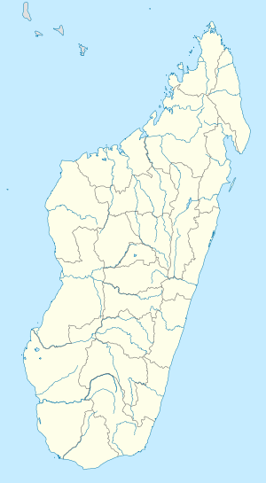 Toamasina Location in Madagascar | |
| Coordinates: 18°09′S 49°25′E / 18.150°S 49.417°E | |
| Country |
|
| Region | Atsinanana |
| Area | |
| • Total | 20 km2 (8 sq mi) |
| Population (2013) | |
| • Total | 274,667 |
| • Density | 14,000/km2 (36,000/sq mi) |
| Time zone | UTC3 (EAT) |
| Climate | Af |
Toamasina [toˈmasinə̥], meaning "like salt" or "salty", unofficially and in French also Tamatave, is the capital of the Atsinanana region on the east coast of Madagascar on the Indian Ocean. The city is the chief seaport of the country, situated 215 km (134 mi) northeast of its capital and biggest city Antananarivo, near the centre of the eastern coast at 18 10 S, 49 32 E. According to the 2013 official estimate, Toamasina had a population of 274,667.[1] The city is served by Toamasina Airport.
Overview
Toamasina owes its importance to the existence of a coral reef which forms a spacious and fairly commodious harbour, entered by two openings. The city center is built on a sandy peninsula which projects at right angles from the general coastline. On this are crowded together a considerable number of houses, with shops and merchant offices located in the main thoroughfares.
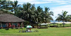
The city has wide palm tree-lined avenues and a wide selection of hotels and restaurants. The beaches in this area are famously beautiful, although sharks and pollution often prevent swimming and watersports. Bazary Be is a famous colorful street market, specializing in exotic spices and locally made handicrafts. The central market in the heart of the city is one of the most popular sites in the city.
History
Under French domination, Toamasina was the seat of several foreign consuls, as well as of numerous French officials, and was the chief port for the capital and the interior. Imports consisted principally of piece-goods, farinaceous foods and iron and steel goods; main exports were gold dust, raffia, hides, caoutchouc (rubber) and live animals. Communication with Europe was maintained by steamers of the Messageries Maritimes and the Havraise companies, and also with Mauritius, and thence to Sri Lanka, by the British Union-Castle Line.[2]
During the colonial period, owing to the character of the soil and the formerly crowded native population, the town was often plagued by epidemics: the plague broke out in 1898, and again in 1900; but since the draining of the neighboring marshes, there was an improvement. After 1895 the native population was removed from the town and settled in a new village to the north-west.[2]
Gervais Rakotomanana is the president of the city by special delegation since 30 May 2007. The former mayor, Roland Ratsiraka, was suspended after a decision in the municipal council in early 2007.
Religion
Toamasina's St. Joseph cathedral is the archiepiscopal see of the Roman Catholic Archdiocese of Toamasina, now Metropolitan of an ecclesiastical province with four suffragan dioceses, since the transfer and promotion on 1939.05.25 of the former Apostolic Prefecture of Vatomandry to Apostolic Vicariate of Tamatave (promoted diocese since 1955, renamed Toamasina 19910, elevated Metropolitan archbishopric since 2010).
Infrastructure
Water Services
JIRAMA (Malagasy Power and Water, acronym in Malagasy: Jiro sy Rano Malagasy) manages the municipal water service in Tamatave. Much of the population relies on privately owned pitcher pumps on wells for water access.[3]
Transport
The town is the railhead for the line to the capital. Pousse-pousse (bicycle rickshaws), tuk-tuk (motorized rickshaws), and taxis are available throughout Toamasina to get around the city. Toamasina is the northern end of the Canal des Pangalanes.
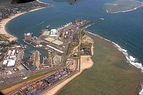
The city is served by Toamasina Airport, which has limited domestic and international service. The city is the country's main seaport for international shipping.
Climate
Toamasina features a tropical rainforest climate under the Köppen climate classification. While Toamasina has no true dry season month where less than 60 millimetres (2.4 inches) of precipitation (on average) falls, the seaport has noticeably wetter and drier periods of the year. September–November is the driest period of the year, while February–April is the wettest time of the year. Average temperatures are relatively constant throughout the course of the year, though it is slightly cooler in the months of July and August, where average highs hover around 24 °C (75 °F) and warmer in the months of January and February, where high temperatures on average reaches 30 °C (86 °F). Toamasina averages roughly 3,368.2 millimetres (132.61 inches) of precipitation annually.
| Climate data for Toamasina (1961–1990, extremes 1889–present) | |||||||||||||
|---|---|---|---|---|---|---|---|---|---|---|---|---|---|
| Month | Jan | Feb | Mar | Apr | May | Jun | Jul | Aug | Sep | Oct | Nov | Dec | Year |
| Record high °C (°F) | 37.4 (99.3) |
38.6 (101.5) |
36.7 (98.1) |
35.0 (95) |
34.0 (93.2) |
29.6 (85.3) |
31.2 (88.2) |
30.2 (86.4) |
30.6 (87.1) |
33.2 (91.8) |
33.0 (91.4) |
33.6 (92.5) |
38.6 (101.5) |
| Average high °C (°F) | 30.1 (86.2) |
30.3 (86.5) |
29.5 (85.1) |
28.8 (83.8) |
27.3 (81.1) |
25.6 (78.1) |
24.8 (76.6) |
24.9 (76.8) |
25.8 (78.4) |
26.9 (80.4) |
28.4 (83.1) |
29.4 (84.9) |
27.6 (81.7) |
| Daily mean °C (°F) | 26.0 (78.8) |
26.1 (79) |
25.5 (77.9) |
24.6 (76.3) |
22.9 (73.2) |
21.1 (70) |
20.4 (68.7) |
20.5 (68.9) |
21.3 (70.3) |
22.7 (72.9) |
24.3 (75.7) |
25.5 (77.9) |
23.4 (74.1) |
| Average low °C (°F) | 22.5 (72.5) |
22.7 (72.9) |
22.4 (72.3) |
21.4 (70.5) |
19.5 (67.1) |
17.8 (64) |
17.1 (62.8) |
17.0 (62.6) |
17.3 (63.1) |
18.7 (65.7) |
20.4 (68.7) |
21.9 (71.4) |
19.9 (67.8) |
| Record low °C (°F) | 18.0 (64.4) |
17.5 (63.5) |
17.0 (62.6) |
15.0 (59) |
13.2 (55.8) |
11.0 (51.8) |
11.8 (53.2) |
10.0 (50) |
11.0 (51.8) |
11.0 (51.8) |
13.5 (56.3) |
16.0 (60.8) |
10.0 (50) |
| Average rainfall mm (inches) | 410.1 (16.146) |
382.1 (15.043) |
478.4 (18.835) |
322.8 (12.709) |
228.3 (8.988) |
259.0 (10.197) |
288.6 (11.362) |
218.2 (8.591) |
121.1 (4.768) |
132.6 (5.22) |
169.7 (6.681) |
357.3 (14.067) |
3,368.2 (132.606) |
| Average rainy days (≥ 1.0 mm) | 19 | 17 | 21 | 18 | 17 | 18 | 22 | 20 | 15 | 13 | 14 | 17 | 211 |
| Average relative humidity (%) | 83 | 83 | 85 | 84 | 85 | 85 | 84 | 85 | 83 | 82 | 83 | 84 | 84 |
| Mean monthly sunshine hours | 224.7 | 198.2 | 191.0 | 196.9 | 192.1 | 162.5 | 162.8 | 184.6 | 209.7 | 232.7 | 236.0 | 219.2 | 2,410.4 |
| Source #1: NOAA[4] | |||||||||||||
| Source #2: Deutscher Wetterdienst (humidity, 1951–1967),[5] Meteo Climat (record highs and lows)[6] | |||||||||||||
Education
- The city is home to the University of Toamasina, which is part of Madagascar's public university system.
- Lycée Français de Tamatave, a French international school, is in Toamasina.
International relations
Twin towns — Sister cities
Toamasina is twinned with:

The city of Holon used to have a street named Tamatave Street (רחוב טמטב), named so in the sixties when Israel had cordial relations with Madagascar. After the assassination of Rehav'am Ze'evi in the 2000s, the street was renamed after him.
See also
Notes
- ↑ Institut National de la Statistique, Antananarivo.
- 1 2 Chisholm 1911, p. 387.
- ↑ MacCarthy, Michael (2014), Low-Cost Household Groundwater Supply Systems for Developing Communities
- ↑ "Tamatave/Toamasina Climate Normals 1961–1990". National Oceanic and Atmospheric Administration. Retrieved October 19, 2015.
- ↑ "Klimatafel von Toamasina (Tamatave) / Madagaskar" (PDF). Baseline climate means (1961-1990) from stations all over the world (in German). Deutscher Wetterdienst. Retrieved April 7, 2017.
- ↑ "Station Toamasina" (in French). Meteo Climat. Retrieved April 7, 2017.
- ↑ Le Port est jumelé à quatre villes portuaires Archived 2015-09-08 at the Wayback Machine. (in French)
References

External links
| Wikivoyage has a travel guide for Toamasina. |
- Map
- (in French) University of Toamasina
- (in French) Regional Tourist information office - Toamasina
- (in French) Regional Harbour of Toamasina
- (in French) https://web.archive.org/web/20170225132257/http://mairie-toamasina.mg/ City Hall of toamasina ]
- (in French) http://www.adopt-tamatave.com/ Association of the native of toamasina ]