Wayne County (Ohio)
Wayne County is een van de 88 county's in de Amerikaanse staat Ohio.
| County in de Verenigde Staten | |||
 | |||
| Situering | |||
| Staat | Ohio | ||
| Tijdzone | Eastern Standard Time (UTC−5) | ||
| Coördinaten | 40°49'48"NB, 81°53'24"WL | ||
| Algemeen | |||
| Oppervlakte | 1.440 km² | ||
| - land | 1.438 km² | ||
| - water | 2 km² | ||
| Inwoners (2000) | 111.564 (78 inw./km²) | ||
| Overig | |||
| Zetel | Wooster | ||
| FIPS-code | 39169 | ||
| Opgericht | 1808 | ||
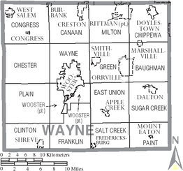
| Detailkaart | |||
 | |||
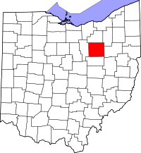
| Overzichtskaart van Wayne County | |||
| Foto's | |||
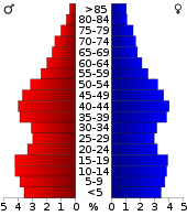 Bevolkingspiramide Wayne County | |||
| Statistieken volkstelling Wayne County | |||
| |||
De county heeft een landoppervlakte van 1.438 km² en telt 111.564 inwoners (volkstelling 2000). De hoofdplaats is Wooster.
Bevolkingsontwikkeling
| Historische inwonertallen | |||
|---|---|---|---|
| Jaar | Inwoners | % ± | |
| 1900 | 37.870 | ||
| 1910 | 38.058 | 0,5% | |
| 1920 | 41.346 | 8,6% | |
| 1930 | 47.024 | 13,7% | |
| 1940 | 50.520 | 7,4% | |
| 1950 | 58.716 | 16,2% | |
| 1960 | 75.497 | 28,6% | |
| 1970 | 87.123 | 15,4% | |
| 1980 | 97.408 | 11,8% | |
| 1990 | 101.461 | 4,2% | |
| 2000 | 111.564 | 10,0% | |
| Bron: (en) Historical Decennial Census Population | |||
.jpg)
Wayne County Courthouse
This article is issued from
Wikipedia.
The text is licensed under Creative
Commons - Attribution - Sharealike.
Additional terms may apply for the media files.