Stark County (Ohio)
Stark County is een van de 88 county's in de Amerikaanse staat Ohio.
| County in de Verenigde Staten | |||
 | |||
| Situering | |||
| Staat | Ohio | ||
| Tijdzone | Eastern Standard Time (UTC−5) | ||
| Coördinaten | 40°48'36"NB, 81°22'12"WL | ||
| Algemeen | |||
| Oppervlakte | 1.504 km² | ||
| - land | 1.492 km² | ||
| - water | 12 km² | ||
| Inwoners (2000) | 378.098 (253 inw./km²) | ||
| Overig | |||
| Zetel | Canton | ||
| FIPS-code | 39151 | ||
| Opgericht | 1808 | ||
| Detailkaart | |||
 | |||
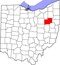
| Overzichtskaart van Stark County | |||
| Foto's | |||
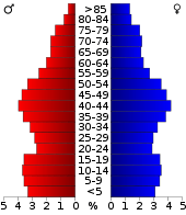 Bevolkingspiramide Stark County | |||
| Statistieken volkstelling Stark County | |||
| |||
De county heeft een landoppervlakte van 1.492 km² en telt 378.098 inwoners (volkstelling 2000). De hoofdplaats is Canton.
Bevolkingsontwikkeling
| Historische inwonertallen | |||
|---|---|---|---|
| Jaar | Inwoners | % ± | |
| 1900 | 94.747 | ||
| 1910 | 122.987 | 29,8% | |
| 1920 | 177.218 | 44,1% | |
| 1930 | 221.784 | 25,1% | |
| 1940 | 234.887 | 5,9% | |
| 1950 | 283.194 | 20,6% | |
| 1960 | 340.345 | 20,2% | |
| 1970 | 372.210 | 9,4% | |
| 1980 | 378.823 | 1,8% | |
| 1990 | 367.585 | −3,0% | |
| 2000 | 378.098 | 2,9% | |
| Bron: (en) Historical Decennial Census Population | |||

Stark County Courthouse
This article is issued from
Wikipedia.
The text is licensed under Creative
Commons - Attribution - Sharealike.
Additional terms may apply for the media files.