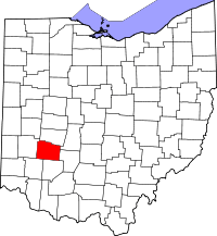
Greene County (Ohio)
Greene County is een van de 88 county's in de Amerikaanse staat Ohio.
| County in de Verenigde Staten | |||
 | |||
| Situering | |||
| Staat | Ohio | ||
| Tijdzone | Eastern Standard Time (UTC−5) | ||
| Coördinaten | 39°41'24"NB, 83°53'24"WL | ||
| Algemeen | |||
| Oppervlakte | 1.078 km² | ||
| - land | 1.075 km² | ||
| - water | 3 km² | ||
| Inwoners (2000) | 147.886 (138 inw./km²) | ||
| Overig | |||
| Zetel | Xenia | ||
| FIPS-code | 39057 | ||
| Opgericht | 1803 | ||
| Detailkaart | |||
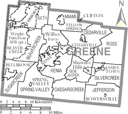 | |||
| Overzichtskaart van Greene County | |||
| Foto's | |||
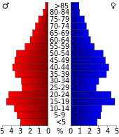 Bevolkingspiramide Greene County | |||
| Statistieken volkstelling Greene County | |||
| |||
De county heeft een landoppervlakte van 1.075 km² en telt 147.886 inwoners (volkstelling 2000). De hoofdplaats is Xenia.
Bevolkingsontwikkeling
| Historische inwonertallen | |||
|---|---|---|---|
| Jaar | Inwoners | % ± | |
| 1900 | 31.613 | ||
| 1910 | 29.733 | −5,9% | |
| 1920 | 31.221 | 5,0% | |
| 1930 | 33.259 | 6,5% | |
| 1940 | 35.863 | 7,8% | |
| 1950 | 58.892 | 64,2% | |
| 1960 | 94.642 | 60,7% | |
| 1970 | 125.057 | 32,1% | |
| 1980 | 129.769 | 3,8% | |
| 1990 | 136.731 | 5,4% | |
| 2000 | 147.886 | 8,2% | |
| Bron: (en) Historical Decennial Census Population | |||
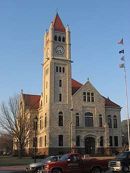
Greene County Courthouse
This article is issued from
Wikipedia.
The text is licensed under Creative
Commons - Attribution - Sharealike.
Additional terms may apply for the media files.