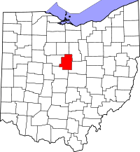
Morrow County (Ohio)
Morrow County is een van de 88 county's in de Amerikaanse staat Ohio.
| County in de Verenigde Staten | |||
 | |||
| Situering | |||
| Staat | Ohio | ||
| Tijdzone | Eastern Standard Time (UTC−5) | ||
| Coördinaten | 40°31'48"NB, 82°48'0"WL | ||
| Algemeen | |||
| Oppervlakte | 1.055 km² | ||
| - land | 1.052 km² | ||
| - water | 3 km² | ||
| Inwoners (2000) | 31.628 (30 inw./km²) | ||
| Overig | |||
| Zetel | Mount Gilead | ||
| FIPS-code | 39117 | ||
| Opgericht | 1848 | ||
| Detailkaart | |||
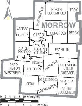 | |||
| Overzichtskaart van Morrow County | |||
| Foto's | |||
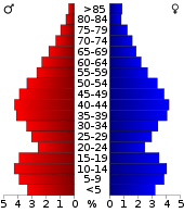 Bevolkingspiramide Morrow County | |||
| Statistieken volkstelling Morrow County | |||
| |||
De county heeft een landoppervlakte van 1.052 km² en telt 31.628 inwoners (volkstelling 2000). De hoofdplaats is Mount Gilead.
Bevolkingsontwikkeling
| Historische inwonertallen | |||
|---|---|---|---|
| Jaar | Inwoners | % ± | |
| 1900 | 17.879 | ||
| 1910 | 16.815 | −6,0% | |
| 1920 | 15.570 | −7,4% | |
| 1930 | 14.489 | −6,9% | |
| 1940 | 15.646 | 8,0% | |
| 1950 | 17.168 | 9,7% | |
| 1960 | 19.405 | 13,0% | |
| 1970 | 21.348 | 10,0% | |
| 1980 | 26.480 | 24,0% | |
| 1990 | 27.749 | 4,8% | |
| 2000 | 31.628 | 14,0% | |
| Bron: (en) Historical Decennial Census Population | |||

Gevangenis van Morrow County
This article is issued from
Wikipedia.
The text is licensed under Creative
Commons - Attribution - Sharealike.
Additional terms may apply for the media files.