Megalopolis
A megalopolis (/ˌmɛɡəˈlɒpəlɪs/), sometimes called a megapolis; also megaregion, city cluster or supercity,[1] is typically defined as a group of two or more roughly adjacent metropolitan areas, which may be somewhat separated or may merge into a continuous urban region. The megalopolis concept became highly influential as it introduced a new, larger scale in thinking about urban patterns and urban growth.[2]
| Population tables and ekistics of world cities |
|---|
.jpg) |
|
History of term megalopolis
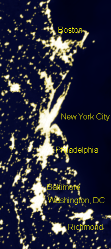
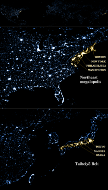
The term was coined by Patrick Geddes in his 1915 book Cities in Evolution,[3][4] and used by Oswald Spengler in his 1918 book The Decline of the West, and Lewis Mumford in his 1938 book The Culture of Cities, which described it as the first stage in urban overdevelopment and social decline. Later, it was used by Jean Gottmann in his landmark 1961 study, Megalopolis: The Urbanized Northeastern Seaboard of the United States, to describe what is now commonly known as the Northeast megalopolis a.k.a. BosWash.[5][6][7] The term has been interpreted as meaning "supercity".[1] In 1994 the magazine National Geographic (Vol 186, No.1 July 1994) featured a "Double Map Supplement: Megalopolis." of Boston to Washington Circa 1830 and on the flip-side a contemporary (1994) map of the same region to coincide with the 33 page feature article "Breaking New Ground: Boston" by William S. Ellis Photographs Joel Sartore. The contemporary 1994 map cites the term Megalopolis being first used in 1961 to refer to the BosWash region.
Definitions
Megalopolis is often spelled Megapolis. Both are derived from μέγας (mégas) in Ancient Greek meaning 'great' and πόλις (pólis) meaning 'city', therefore literally a 'great city' (compare "megacity"). Because in Greek, πόλις is feminine, the etymologically correct term is megalopolis. Literally, megalopolis in Greek means a city of exaggerated size where the prefix megalo- represents a quantity of exaggerated size.[8] The Ancient Greek city of Megalopolis was formed by the Arcadian League by bringing together smaller communities.
A megalopolis, also known as a megaregion, is a clustered network of cities. Gottmann defined its population as 25 million.[9] Doxiadis defined a small megalopolis a similar cluster with a population of about 10 million.[10][11][12] America 2050,[13] a program of the Regional Plan Association, lists 11 megaregions in the United States and Canada.[10] Megaregions of the United States were explored in a July 2005 report by Robert E. Lang and Dawn Dhavale of the Metropolitan Institute at Virginia Tech.[14] A later 2007 article by Lang and Nelson uses 20 megapolitan areas grouped into 10 megaregions.[15] The concept is based on the original Megalopolis model.[12]
Modern interlinked ground transportation corridors, such as rail and highway, often aid in the development of megalopolises. Using these commuter passageways to travel throughout the megalopolis is informally called megaloping. This term was coined by Davide Gadren and Stefan Berteau.[16]
In Brazil, the term megarregião has a legal meaning, different from the English word megaregion: Mesoregions of Brazil (mesorregião) and Microregions of Brazil (microrregião).
In China, the official term corresponding to the meaning of "megalopolis" is 城市群 (chéngshì qún), which literally means "city cluster". In Standard for basic terminology of urban planning (GB/T 50280—98) issued in 1998, 城市群 is defined as "An area in which cities are relatively densely distributed in a certain region" but wrongly translated as "agglomeration". In addition, there used to be no clear distinction between "megalopolis" and "metropolitan area" (都市圈) in Chinese context until National Development and Reform Commission issued Guidelines on the Cultivation and Development of Modern Metropolitan Areas on 19 February 2019 and clarified the definition of a metropolitan area.
Africa
- Cairo–Giza–Qalyubia–Helwan–6th of October City (Greater Cairo), Egypt (16 million) The area around the Nile is also very densely populated.
- Nile River Delta Governorates (Alexandria, Beheira, Kafr el-Sheikh, Gharbia, Monufia, Qalyubia, Dakahlia, Damietta, Al Sharqia, and Port Said) have a combined population of 41,045,135. The total area of these Governorates is 18,199 square miles making the population density 2,255.4 per square mile.
- The Gauteng City Region (PWV) in South Africa, which includes the urbanised portion of Gauteng Province (Pretoria, Centurion, Midrand, Johannesburg and the Vaal Triangle, with a population of over 14 million)[17][18][19]
- The region in Morocco including El Jadida-Casablanca-Rabat-Salé-Kenitra, concentrating in the long coastal belt, on around 250 km with a depth of 40 to 50 km, more than 11 million inhabitants.
- The Nairobi Metropolitan Region consisting of the counties of (Kajiado-Kiambu-Nairobi-Machakos-Murang'a) in Kenya, which have a combined population of 8 million people.[20]
North America
Transnational
Canada
| Megalopolis name | Population in millions 2011 |
Population in millions 2025 (projected) |
Population percent growth 2011 - 2025 (projected) |
Major cities | Related articles |
|---|---|---|---|---|---|
| Quebec City–Windsor Corridor | 18.4 | 21 | 14.1% | Hamilton, Kingston, Kitchener, London, Mississauga, Montreal, Oshawa, Ottawa, Peterborough, Quebec City, Toronto, Trois-Rivières, Vaughan, Windsor | Southern Ontario |
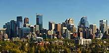
| Calgary–Edmonton Corridor | 2.7 | 4 | 48.1% | Calgary, Edmonton, Red Deer, St. Albert, Airdrie | Calgary Region, Edmonton Capital Region, Central Alberta |
Mexico
| Megalopolis name | Population in millions 2015 |
Population in millions 2025 (projected) |
Population percent growth 2000 - 2025 (projected) |
Major cities | Related articles |
|---|---|---|---|---|---|
| Bajío | 11 | ? | ?% | León, Querétaro, Aguascalientes, Celaya, Irapuato, San Juan del Río, Salamanca | Bajío |
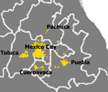
| Mexico City megalopolis | 28 | ? | ?% | Mexico City, Puebla, Cuernavaca, Toluca, Pachuca, Tula, Tlaxcala, Cuautla, Tulancingo | Mexico City megalopolis |
Note: Tijuana, Mexico is part of the Southern California megalopolis.
United States

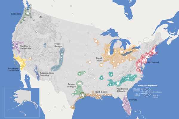
Constituent urban areas of each megalopolis are based on reckoning by a single American organization, the Regional Plan Association (RPA). The RPA definition of the Great Lakes Megalopolis includes some Canadian metropolitan areas with the United States including some but not all major urban centres in the Windsor-Quebec City Corridor. Note that one city, Houston, is listed in two different Megalopolis regions as defined by the RPA, (the Gulf Coast and Texas Triangle).[10][21]
South America
Argentina
| Megalopolis Name | Population in 2013 |
Major cities | Other cities |
|---|---|---|---|
| Greater Buenos Aires | 13,641,973 | Buenos Aires; Merlo, Moreno; Quilmes; Florencio Varela, La Matanza | Lanús; Lomas de Zamora, San Martin; and Avellaneda |
Brazil
| Megalopolis Name | Population in 2015[24] |
Major cities | Other cities |
|---|---|---|---|
| São Paulo Macrometropolis | +32,200,000 | São Paulo and Campinas and São José dos Campos | Sorocaba, Jundiaí, São José dos Campos, Piracicaba and Santos |
| Greater Rio de Janeiro | +12,000,000 | Rio de Janeiro and São Gonçalo | Nova Iguaçu, Duque de Caxias, Niterói, Belford Roxo and São João de Meriti |
| Greater Belo Horizonte | +5,800,000 | Belo Horizonte and Contagem | Betim, Nova Lima and Sete Lagoas |
| Greater Porto Alegre | +4,200,000 | Porto Alegre and Canoas | São Leopoldo, Novo Hamburgo and Gravataí |
| Recife metropolitan area | +3,900,000 | Recife and Jaboatão dos Guararapes | Olinda, Paulista, Cabo de Santo Agostinho, Camaragibe, Igarassu, São Lourenço da Mata, Abreu e Lima, Ipojuca, Moreno, Itapissuma, Ilha de Itamaracá, Araçoiaba and Goiana |
| Salvador metropolitan area | +3,900,000 | Salvador and Camaçari | São Francisco do Conde, Lauro de Freitas, Simões Filho, Candeias, Dias d'Ávila, Mata de São João, Pojuca, São Sebastião do Passé, Vera Cruz, Madre de Deus and Itaparica |
| Greater Curitiba | + 3,500,000 | Curitiba and São José dos Pinhais | Araucária, Colombo, Fazenda Rio Grande, Lapa and Pinhais |
Colombia
The following megaregions in Colombia are expected to have nearly 93% (55 Million people) of its population by 2030, up from the current 72%. There are currently 4 major megaregions in Colombia.
| Megalopolis name | Population in 2015 | Population in 2030 (projected) | Major cities |
|---|---|---|---|
| Bogota National Capital Metropolis | 17,000,000 | 26,500,000 | Bogotá, Soacha, Facatativá, Chía, Tunja, Fusagasugá, Zipaquirá, Madrid, Funza, Cajicá, Ubaté, Sibaté, Guaduas, Villa de Leyva and Tocancipá |
| Pacific Belt | 9,000,000 | 14,000,000 | Medellín, Cali, Bello, Pereira, Manizales, Armenia, Itagüí, Yumbo, and Palmira |
| Northeast Atlantic Region | 6,000,000 | 10,500,000 | Barranquilla, Cartagena, Santa Marta, Ciénaga, Malambo, Baranoa and Turbaco |
| Santander Belt | 3,000,000 | 5,200,000 | Bucaramanga, Cúcuta, Ocaña, and Pamplona |
Other sources[25] show that another megaregion may be considered:
| Megalopolis name | Population in 2015 | Population in 2030 (projected) | Major cities |
|---|---|---|---|
| Golden Triangle | 29,500,000 | 41,000,000 | Bogotá, Soacha, Medellín, Cali, Bello, Manizales, Armenia |
Peru
| Megalopolis name | Population in 2013 |
Major cities | Other cities |
|---|---|---|---|
| Lima-Callao Megalopolis | 10,523,796 | Lima and Callao | Cono Norte, Cono Sur, and Cono Este |
Venezuela
| Megalopolis name | Population in 2013 |
Major cities | Other cities |
|---|---|---|---|
| Caracas-Valencia Megalopolis | +9,000,000 | Caracas, Valencia, and Maracay | Cagua, Maiquetía, and Guatire |
Asia
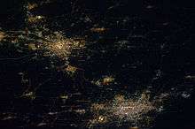
East Asia

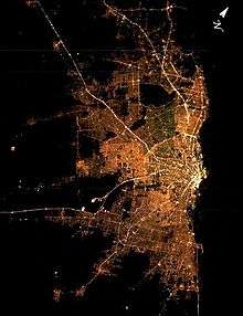
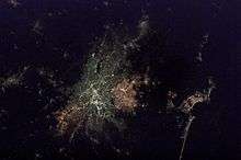
.jpg)
.jpg)

China

- Pearl River Delta Megalopolis (珠江三角洲) a.k.a. Guangdong-Hong Kong-Macau Greater Bay Area (粤港澳大湾区): Hong Kong, Shenzhen, Dongguan, Guangzhou, Foshan, Jiangmen, Zhongshan, Zhuhai, Macau, Huizhou (55,000,000).[26][27] Pan-Pearl River Delta further includes provinces adjacent to Guangdong.
- Yangtze River Delta Megalopolis (长江三角洲): Shanghai, Nanjing, Hangzhou, Ningbo, Suzhou, Jingjiang, Wuxi, Changzhou, Zhenjiang, Yangzhou, Taizhou, Nantong, Huzhou, Jiaxing, Shaoxing, Jiangyin, Haimen, Zhangjiagang, Zhoushan, Ma'anshan (88,000,000)[28]
- Bohai Economic Rim (环渤海经济圈): Beijing, Shenyang, Tianjin, Dalian, Anshan, Fushun, Dandong, Sinuiju, Tangshan, Yantai, Jinan, Qinhuangdao, Qingdao, Weihai (66,400,000)[29]
- Western Taiwan Straits Economic Zone (海峡西岸经济区): Xiamen, Fuzhou, Wenzhou, Shantou, Jieyang, Chaozhou (25,000,000)
- Central Plain (中原): Kaifeng, Xinxiang, Zhengzhou, Luoyang (14,170,000)
- Central-Southern Liaoning (辽中南): Within 150 km from its center Shenyang (7.2 million), it has Fushun (3 million), Anshan City (3.6 million), Benxi (1.5 million), Liaoyang (1.8 million), Yingkou (2.2 million), Panjin (1.2 million), and Tieling (3.4 million), with a total population of 23 million. And it can be further extended to Dalian (6.2 million), Fuxin (2 million) and Dandong (2.4 million). This area used to be the most industrialized region in China but began to decline in the 1980s.
- Harbin-Changchun Megalopolis (哈长城市群) a.k.a. Northeastern Cities (东北城市群): Harbin, Qiqihar, Daqing, Changchun, Jilin City, Siping including Rason in North Korea and Vladivostok in Russia (21,832,000)
- Sichuan basin (四川盆地) a.k.a. Chengyu Megalopolis (成渝都市圈): Chengdu, Chongqing, Zigong, Luzhou (20,878,000)
- Greater Wuhan Megalopolis (大武汉都市圈): Wuhan, Huangshi, Xinyang, Jiujiang, Yueyang (20,000,000)
- Guanzhong (关中): Xi'an, Xianyang, Baoji, Weinan (16,722,000)
- Changzhutan Megalopolis (长株潭城市群) a.k.a. Greater Changsha Metropolitan Region (大长沙都市圈): Changsha, Zhuzhou, Xiangtan (12,994,400 in 2000)
In July 2012, the Economist Intelligence Unit brought out a report entitled; Supersized cities: China’s 13 megalopolises, which pinpoints the 13 emerging megalopolises in China, and highlights the demographic and income trends that are shaping their development.
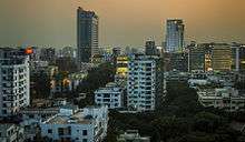
Japan
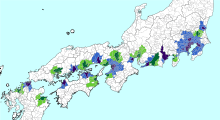
Japan is made up of overlapping megapolises. The Taiheiyō Belt megapolis itself includes both the Greater Tokyo Area and Keihanshin megapoles.
South Korea
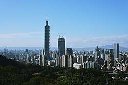
Taiwan
South Asia
Sri Lanka
Western Region Supercity of Colombo (Megapolis) with 3,687 km2 (1,424 sq mi) land area and currently over 7 million population comprising several municipal, urban, and town councils politically. This is planned to be spacious and modern megacity with dedicated core zones for financial, trade, industrial, educational, logistic, transport, health, sports, recreational activities and services in par with the international level. Once completed it would be one of the most livable and favored cities in the world.
India
- Kolkata Megalopolis[35] - Some areas of Presidency, Medinipur and burdwan divisions. Population 65 million.
- Delhi Megalopolis[36] - National Capital Region (India). Population 46 million.
- Mumbai Megalopolis[37] - Mumbai Megalopolis includes Mumbai Metropolitan Region, Pune Metropolitan Region and Nashik Metropolitan Region. This area is also known as golden Triangle of Maharashtra.[38][39] Population 80 million.
Bangladesh
- Dhaka (Greater Dhaka Megalopolis consists four city Corporations: Dhaka South, Dhaka North, Gazipur, and Narayanganj and five municipals: Savar Upazila (A class), Dohar Upazila (A class), Dhamrai Upazila (A class), Tongi (Special Class), Sonargaon (B class) (17,000,000)
- Chittagong (4,009,423)
Pakistan
Karachi comprises six district municipal corporations. The total population is 24 million according to the 2011 census.
Nepal
Kathmandu valley, which consists of 5 municipalities namely Kathmandu, Lalitpur, Bhaktapur, Kirtipur and Madhyapur Thimi, along with the peripheral cities of Banepa, Panauti and Dhulikhel.
Southeast Asia
| Rank | Megalopolis Name | Country | Population in millions |
Major cities |
|---|---|---|---|---|
| 1 | Java | 145[40] | Serang, Tangerang, South Tangerang, Jakarta, Bekasi, Depok, Bogor, Sukabumi, Cimahi, Bandung, Tasikmalaya, Cirebon, Tegal, Pekalongan, Semarang, Surakarta, Yogyakarta, Madiun, Kediri, Mojokerto, Surabaya, Batu, Malang, Pasuruan, Probolinggo | |
| 2 | Mega Manila | 40+ | Manila, Calamba, Angeles, Baguio, Batangas, Dagupan, Olongapo, Bacoor | |
| 3 | Central Thailand | 25+ | Bangkok, Ayuthaya, Pattaya | |
| 4 | Southeast Economic Zone | 16+ | Đồng Nai, Bình Dương, Ho Chi Minh City, Bà Rịa–Vũng Tàu Province, Long An, Tiền Giang |
Philippines
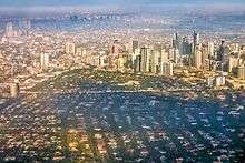
Mega Manila is made up of 4 Regions:
- Central Luzon (11,218,117)
- Metro Manila (12,877,253)
- Calabarzon (14,414,774)
- Mimaropa excluding Palawan (2,113,891)
(Regional Centers) San Fernando-Manila-Calamba-Calapan
Total Population of Mega Manila as of 2015: (40,624,035)[41]
Thailand, Malaysia, Singapore, Indonesia and Vietnam
West Asia
Iran
- Greater Tehran: A region located in Iranian Tehran and Alborz Province in central Northern Iran with its influence expanding in Qom Province, Qazvin Province and Mazandaran Province, home for at least 15 million people, it is one of the most populous urban areas in the Greater Middle East and the surrounding regions. Tehran was a small village 200 years ago when it was first chosen as the Capital city and it has been growing at a very fast rate.
Turkey
(all figures extrapolated from end of 2014 and end of 2015 figures of,[47] to middle of year 2016)
- Greater Istanbul: Includes Istanbul city proper, with continuous urbanization spilling over to neighboring provinces, as well as nearby dense population and highly industrialized areas. Istanbul, eastern counties of Tekirdağ province, entire coast of Izmit bay, and Adapazarı add up to 17.5 million population.
- Other major cities: Ankara (5 million), Izmir (includes satellites Torbalı-Aliağa-Urla-Manisa to add up to 4 million), Adana-Tarsus-Mersin (3 million), Bursa (2.1 million)
Europe
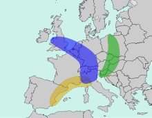
Transnational (Europe)
| Rank | Megalopolis Name | Population in millions | Countries & Respective Cities |
|---|---|---|---|
| 1 | Blue Banana | 110–130[48] | |
| 2 | Golden Banana | 40–45[49] | |
| 3 | Green Banana | 12 | |
| 4 | STRING | 11.5[50] | |
| 5 | Atlantic Axis | 10[51][52] | |
| 6 | Gulf of Finland | 8 |
Oceania
Australia
| Megalopolis Name | Population in millions |
Major cities |
|---|---|---|
| Sydney Region[53] | 5.77[54] | Greater Sydney (including Central Coast and Blue Mountains) (4.97 million), Newcastle and Lake Macquarie (501,000), Illawarra (300,000) |
| Port Phillip Bay Area | 4.98[54] | Greater Melbourne (including Mornington Peninsula) (4.7 million), Greater Geelong (233,429), Melton, Victoria (54,455) |
| South East Queensland | 3.52[54] | Brisbane City (1.21 million), Gold Coast (591,300), Tweed Heads (8,200), Logan City (320,500), Redland City ( 139,600 ), Moreton Bay Region ( 450,000 ), Sunshine Coast (311,000), Noosa ( 54,600 ), Ipswich ( 206,000 ), Lockyer Valley ( 40,000), Toowoomba (166,000), Somerset ( 25,500 ), Note (excluding Scenic Rim (41,700)) |
New Zealand
See talk section for discussion on long-term projections for North Island and far long-term South Island.
Megalopolis in Fiction
Metropolis
Metropolis is a 1927 German expressionist science-fiction drama film directed by Fritz Lang. Written by Thea von Harbou in collaboration with Lang,[55][56] it stars Gustav Fröhlich, Alfred Abel, Rudolf Klein-Rogge and Brigitte Helm. Erich Pommer produced it in the Babelsberg Studios for Universum Film A.G. (Ufa). The silent film is regarded as a pioneering science-fiction movie, being among the first feature-length movies of that genre.[57] Filming took place over 17 months in 1925–26 at a cost of over five million Reichsmarks.[58]
Judge Dredd
Judge Dredd (1977) Mega-City One is a huge fictional megalopolis-size city-state covering much of what is now the Eastern United States and some of Canada in the Judge Dredd comic book series and its spinoff series. The exact geography of the city depends on which writer and artist has done which story, but from its first appearance it has been associated with New York City's urban sprawl; originally it was presented as a future New York, which was retconned as the centre of a "Mega-City One" in the very next story.[59] The Architects' Journal placed it at No. 1 in their list of "comic book cities".[60]
Blade Runner
Blade Runner (1982 Film) - Blade Runner is a 1982 neo-noir science fiction film directed by Ridley Scott, written by Hampton Fancher and David Peoples, and starring Harrison Ford, Rutger Hauer, Sean Young, and Edward James Olmos. It is a loose adaptation of Philip K. Dick's novel Do Androids Dream of Electric Sheep? (1968). The film is set in a dystopian future Los Angeles of 2019, in which synthetic humans known as replicants are bio-engineered by the powerful Tyrell Corporation to work on off-world colonies. When a fugitive group of replicants led by Roy Batty (Hauer) escapes back to Earth, burnt-out cop Rick Deckard (Ford) reluctantly agrees to hunt them down.
Sprawl Trilogy
In William Gibson's fiction, the Sprawl is a colloquial name for the Boston-Atlanta Metropolitan Axis (BAMA), an urban sprawl environment on a massive scale, and a fictional extension of the real Northeast megalopolis. The Sprawl is a visualization of a future where virtually the entire East Coast of the United States, from Boston to Atlanta, has melded into a single mass of urban sprawl.[61] It has been enclosed in several geodesic domes and merged into one megacity. The city has become a separate world with its own climate, no real night/day cycle, and an artificial sky that is always grey.
See also
|
|
References
- Fielder, W.; Feeney, Georgiana (1976). Inquiring about Cities: Student text. Holt, Rinehart and Winston. pp. 193, 299. ISBN 9780030897849. Retrieved 2018-06-25.
- Caves, R. W. (2004). Encyclopedia of the City. Routledge. p. 456. ISBN 9780415252256.
- Geddes, Patrick (1915). Cities in Evolution. London: Williams & Norgate – via Internet Archive.
- "MEGALOPOLIS". Environmental Cloud Atlas. Syracuse University School of Architecture.
Patrick Geddes coined this term in the early twentieth century that described the regional city's counter-action through the process of conurbation...
- Gottmann, Jean (1954). L'Amerique. Paris: Hachette.
- Gottmann, Jean (1957). "Megalopolis, or the urbanization of the Northeastern Seaboard". Economic Geography. 33 (3): 189–200. doi:10.2307/142307. JSTOR 142307.
- Gottmann, Jean (1961). Megalopolis. The Urbanized Northeastern seaboard of the United States. New York: The Twentieth Century Fund.
- "Definition of the prefix megalo-". The American Heritage® Dictionary of the English Language, Fourth Edition. Houghton Mifflin Company. 2000.
- Gottmann, Jean (1989). Since Megalopolis. The Urban Writings of Jean Gottmann. Baltimore and London: The Johns Hopkins University Press. p. 163.
- Taylor, Matt. "Megaregions". America 2050. Archived from the original on 2017-05-16. Retrieved 2017-04-06.
- "Who's Your City?: What Is a Megaregion?". 19 March 2008. Archived from the original on 12 June 2010. Retrieved 5 October 2014.
- "Cities: Capital for the New Megalopolis". Time. 4 November 1966. Archived from the original on 27 August 2013. Retrieved 19 July 2010.
- "About Us". America 2050. Archived from the original on 6 October 2014. Retrieved 5 October 2014.
- "Beyond Megalopolis: Exploring America's New "Megapolitan" Geography" (PDF). July 2005. Archived from the original (PDF) on 2009-03-27.
- "America 2040: The Rise of the Megapolitans" (PDF). January 2007. Archived (PDF) from the original on 24 July 2013. Retrieved 5 January 2014.
- Tremble, Sam (30 May 2007). "Fumbling Toward Portland". Philadelphia City Paper. Archived from the original on 7 July 2009.
- "Archived copy". Archived from the original on 2006-10-07. Retrieved 2007-01-01.CS1 maint: archived copy as title (link)
- "Archived copy". Archived from the original on 2006-09-24. Retrieved 2007-01-01.CS1 maint: archived copy as title (link)
- "Welcome to the official South African government online site! | South African Government". Info.gov.za. Archived from the original on 2012-05-14. Retrieved 2017-04-06.
- "Cabinet Secretary names team to modernize Nairobi city transport :: Kenya - The Standard". Standardmedia.co.ke. 2015-02-23. Archived from the original on 2015-07-13. Retrieved 2017-04-06.
- Regional Plan Association (2008). America 2050: An Infrastructure Vision for 21st Century America. New York: Regional Plan Association.
- "Megapolitan: Arizona's Sun Corridor". Morrison Institute for Public Policy. May 2008. Archived from the original on 2008-06-15. Retrieved 2008-06-03.
- Catherine Reagor (2006-04-09). "When Phoenix, Tucson Merge". The Arizona Republic. Retrieved 2016-05-31.
- 46 - Instituto Brasileiro de Geografia e Estatística, Brazil, 2015, Brazilian Institute of Geography and Statistics, 28 August 2015, archived from the original on 19 December 2016, retrieved 28 August 2016
- Ordóñez Burbano, Luis A. (2007). Universidad del Valle 60 años 1945-2005: Atando cabos en clave de memoria. Cali, Valle del Cauca, Colombia: Universidad del Valle. p. 58. OCLC 645219600
- John Vidal. "UN report: World's biggest cities merging into 'mega-regions' | World news". The Guardian. Archived from the original on 2017-05-08. Retrieved 2017-04-06.
- "关于长江三角洲构建世界第六大城市群的思考". Archived from the original on 23 September 2015. Retrieved 5 October 2014.
- Vidal, John (2010-03-22). "UN report: World's biggest cities merging into 'mega-regions'". The Guardian. London. Archived from the original on 2016-09-10. Retrieved 2016-09-09.
- "Foreign investment shows trend of "moving northward"". china-embassy.org. 2004-05-14. Archived from the original on 2011-06-11. Retrieved 2010-01-09.
- "地域活性化戦略(案)資料" (PDF) (in Japanese). Ministry of Economy, Trade and Industry. p. 4. Archived (PDF) from the original on September 23, 2016. Retrieved August 13, 2016.
- "2015 Population Census". Statistics Bureau, Ministry of Internal Affairs and Communications. Archived from the original on August 25, 2016. Retrieved August 13, 2016.
- United Nations (March 12, 2017). "The World's Cities in 2016" (PDF). United Nations
- Japan Statistics Bureau - "2010 Census", retrieved August 23, 2015
- A government publication states that on 1 November 2010, the population of "Seoul Metropolitan Area" stood at 23,616 thousand, which is the sum of the figures given for Gyeonggi-do (11,270 thousand), Seoul (9,708 thousand) and Incheon (2,638 thousand), apparently including the periphery.
Source: "Preliminary Results of the 2010 Population and Housing Census" Archived 2012-01-31 at the Wayback Machine (PDF). Statistics Korea. 21 January 2011. Retrieved 23 July 2011. - Issues in Global Environment—Climate and Climate Change: 2013 Edition. May 2013. ISBN 9781490109657.
- Kumar, Ashok (2013), "Delhi: Growing Problems of a Growing Megalopolis", in Misra, R. P. (ed.), Urbanisation in South Asia, Foundation Books, pp. 109–141, doi:10.1017/9789382993087.005, ISBN 9789382993087, retrieved 2019-08-21
- "Mumbai set to become next Megalopolis". The Times of India. 2001-09-03. Retrieved 2019-08-21.
- Kumar, K. Ram (2011-04-26). "A megalopolis with unlimited potential". @businessline. Retrieved 2019-08-21.
- "Golden Triangle zone a litmus test for parties in Maharashtra polls". The Economic Times. 2014-09-30. Retrieved 2019-08-21.
- "Java - Google Arts & Culture". Google Cultural Institute. Retrieved 2018-02-07.
- "Google". Archived from the original on 2017-04-06. Retrieved 2017-04-06.
- https://www.singstat.gov.sg/find-data/search-by-theme/population/population-and-population-structure/latest-data
- https://knoema.com/atlas/Malaysia/Johor/Population
- http://population.city/indonesia/batam/
- "广西北部湾经济区概况". Archived from the original on 6 October 2014. Retrieved 5 October 2014.
- "Chinese Cities on Beibu Gulf Increase Cooperation". Archived from the original on 13 November 2013. Retrieved 5 October 2014.
- Turkish Statistical Institute - Address Based Population Record System
- Ina Schmidt. "The European Blue Banana". Archived from the original on 6 October 2014. Retrieved 5 October 2014.
- Pedrazzini, Luisa; Akiyama, Renata Satiko (2011). From Territorial Cohesion to the New Regionalized Europe. ISBN 9788838760341. Retrieved 5 October 2014.
- "What is STRING?". STRING. Archived from the original on 2018-02-26. Retrieved 2018-02-26.
- Lois-González, Rubén C. (7 October 2004). "A Model of Spanish-portuguese Urban Growth: the Atlantic Axis". Universidad de Santiago de Compostela. p. 7(287). Archived from the original on 8 December 2017. Retrieved 7 December 2017.
- "EIXO ATLANTICO DO NOROESTE PENINSULAR".
- http://soac.fbe.unsw.edu.au/2011/papers/SOAC2011_0030_final(1).pdf
- 3218.0 - Regional Population Growth, Australia, 2014-15, Australian Bureau of Statistics, 30 March 2016, archived from the original on 5 October 2016, retrieved 3 October 2016
- Magid 2006, p. 129.
- Grant 2003, p. 14.
- "Metropolis (1927)" Science Fiction Film History. Retrieved 15 May 2013. Quote: "Although the first science fiction film is generally agreed to be Georges Méliès' A Trip To The Moon (1902), Metropolis (1926) is the first feature length outing of the genre."
- Hahn, Ronald M. and Jansen, Volker (1998) Die 100 besten Kultfilme [The 100 best cult movies] Munich: Heyne Filmbibliothek. p.396. ISBN 3-453-86073-X (German)
- 2000 AD No. 2 and 3
- Top 10 comic book cities: #1 Mega City One, Architects' Journal, July 8, 2009
- Markoff, John (November 25, 1990). "Ideas & Trends; Art Invents A Jarring New World From Technology". The New York Times. The New York Times Company. Retrieved 2008-07-30.
External links
| Look up megalopolis in Wiktionary, the free dictionary. |