Yorkeys Knob, Queensland
Yorkeys Knob is a coastal suburb of Cairns, in Cairns Region, Far North Queensland, Australia.[2] It is approximately 13 kilometres (8.1 mi) north of the centre of Cairns, and is the third beach suburb after Machans Beach and Holloways Beach.
| Yorkeys Knob Queensland | |||||||||||||||
|---|---|---|---|---|---|---|---|---|---|---|---|---|---|---|---|
 Yorkeys Knob Beach | |||||||||||||||
 Yorkeys Knob | |||||||||||||||
| Coordinates | 16°49′24″S 145°42′57″E | ||||||||||||||
| Population | 2,759 (2016 census)[1] | ||||||||||||||
| Postcode(s) | 4878 | ||||||||||||||
| LGA(s) | Cairns Region | ||||||||||||||
| State electorate(s) | Barron River | ||||||||||||||
| Federal Division(s) | Leichhardt | ||||||||||||||
| |||||||||||||||
Geography

Yorkeys Knob is a coastal suburb with predominantly low-lying land (less than 10 metres above sea level) with the exception of the hill (known as Yorkeys Knob) rising to 60 metres on the coast at Yorkeys Point. The northern part of the suburb near the coast is residential, but the majority of the land use is rural, mainly used for growing sugarcane. There is a long sandy beach along the Coral Sea.[3]


The Finfish Group operate a 17 hectare pond farm (called Ponderosa) which is capable of producing 350 tonnes of fish per annum. They principally raise giant grouper fish as they are fast growing with a high commercial value.[4]
The suburb is bounded by the Coral Sea to the north, Thomatis Creek to the east, Captain Cook Highway to the south, and Half Moon Creek to the north-west.[3]
History
Yorkeys Knob got its name from George Lawson,[5] a Yorkshire-born, Cairns-based beche-de-mer fisherman.[2][6] (From the nickname Yorkey, and the Hill being the “Knob”.)
On 10 June 1886 Yorkey Lawson reported the loss of a man and his wife from Green Island. They had left to visit the wreck of the Upolu, intending to return the same day. Lawson made a search for them, but was unable to find any trace of them, not even an accident. The pilot cutter was sent to search for the couple.[7]
Lawson built a homestead adjoining the Mount Buchan estate near what is now Yorkeys Knob. During the off-fishing season he and his sons farmed pumpkins, sweet potatoes and paddy melons, but not successfully. Whatever the bandicoots and pigs didn't eat, the crocodiles did. Lawson used the mangroves near his homestead for the firewood and water needed for his beche-de-mer smoking station on Green Island.
Locals are attached to the name, despite the reaction it sometimes gets ("knob" being a slang term for penis), and successfully prevented a developer from advertising a development as being at "Yorkeys Beach".
At the 2011 census, the population of Yorkeys Knob was 2,766.[8]
Facilities
Yorkeys Knob has a supermarket, post office, bottleshop, bakery, and a variety of other shops. A newsagent and a small store are on the beachfront, near the main swimming area.
Yorkeys Knob has three restaurants. One at the Half Moon Bay marina has an over-the-water deck looking across Half Moon Bay to Double Island and Haycock Island (also known as Scout's Hat due to its shape).
Recreation
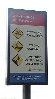
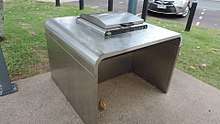
The swimming area is at the northern end of Sims Esplanade. It is patrolled for 6 months of the year by Surf Lifesaving Queensland, and has a stinger net to protect swimmers from box jellyfish (Chironex fleckeri). The safest swimming is between the flags placed by the lifesavers; there have been drownings around the rocks a short distance away. There are barbecue and picnic facilities, plus public toilets and showers.[9] The beach is lined with she-oak casuarinas, beach almonds, ballnuts and coconut palms. At its southern end the beach meets Thomatis Creek, which lies between Yorkeys Knob and Holloways Beach.
The beach is a popular for kitesurfing and windsurfing.

Half Moon Bay Golf Club is located at the western end of Wattle Street, and is a short but challenging layout which features a number of water hazards. It is 5,129 metres long and par is 70.[10] Most of the course is sand-based, and it dries rapidly after heavy rains. A 9-hole course is generally open even if all the other Cairns courses are closed due to flooding, although cyclones can force its closure for a couple of days.
Wildlife

The golf club is a very good bird-watching location, with masked lapwings, bush stone-curlews, a range of kingfishers, rainbow lorikeets and sea eagles fairly easy to find. Between the 12th and 13th holes lies Ray Howarth Park, which is home to a huge colony of flying foxes, which you can see heading out searching for food in the early evenings. During the day they hang upside down from the mangrove's trees, and make an almighty din. When the melaleucas are in flower you will find them gorging on nectar in the trees at the northern end of Sim's Esplanade.
A small bush track near the State school offers a chance to see a variety of birdlife, monitor lizards, and lots of skinks. Along the beach you will find pied oyster catchers, bush stone-curlews, ghost fiddler crabs and sand-bubbler crabs. At the rocks at the end of the beach keep an eye out of the beach tree skink scampering around the rocks looking for lunch, while you also watching for a pod of bottlenose dolphins that sometimes visit the small bay on the northern side of the groyne.
Public transport
Yorkeys Knob is serviced by Sunbus seven days a week. Yorkeys Knob Sunbus Service The normal service, the 1C, runs hourly Monday to Saturday, and every second hour on Sundays. This service also runs to the Smithfield shopping centre, the nearest large shopping complex. A direct service, the 1D, is available during the peak periods, travelling to Cairns in the mornings and back to Yorkeys in the late afternoon.
Heritage listings
Yorkeys Knob has a number of heritage-listed sites, including:
- 40 Buckley Street: Second Innisfail Court House, relocated to Yorkeys Knob as a private residence [11]
References
- Australian Bureau of Statistics (27 June 2017). "Yorkeys Knob (State Suburb)". 2016 Census QuickStats. Retrieved 18 April 2018.

- "Yorkeys Knob (entry 45635)". Queensland Place Names. Queensland Government. Retrieved 1 November 2013.
- "Queensland Globe". State of Queensland. Retrieved 6 May 2018.
- FinFish Group (24 August 2015). "Presentation to Joint Select Committee: Inquiry into Opportunities for Expanding the Aquaculture Industry in Northern Australia". Australian Government. Archived from the original on 6 May 2018. Retrieved 6 May 2018.
- "The Early History Of Yorkeys Knob". Yorkeys Knob Information. Archived from the original on 19 August 2016.
- Williams, Mary T (1988), The Knob - a history of Yorkey's Knob, M. Williams, ISBN 978-1-86252-622-8
- The Cairns Post, 10 June 1886
- Australian Bureau of Statistics (31 October 2012). "Yorkeys Knob (State Suburb)". 2011 Census QuickStats. Retrieved 30 December 2014.
- "Yorkey's Knob Foreshore Park". Cairns Regional Council. 22 September 2017. Archived from the original on 6 May 2018. Retrieved 6 May 2018.
- "Course Information". Half Moon Bay Golf Club. Archived from the original on 11 March 2018. Retrieved 6 May 2018.
- "Innisfail Court House (former) (entry 602500)". Queensland Heritage Register. Queensland Heritage Council. Retrieved 7 July 2013.
External links
| Wikimedia Commons has media related to Yorkeys Knob, Queensland. |