Palm Cove, Queensland
Palm Cove is a coastal suburb of Cairns in the Cairns Region, Queensland, Australia.[2] It is 27 kilometres (17 mi) north of the city of Cairns. It is named after the palm trees that line the beach.
| Palm Cove Cairns, Queensland | |||||||||||||||
|---|---|---|---|---|---|---|---|---|---|---|---|---|---|---|---|
 | |||||||||||||||
 Palm Cove | |||||||||||||||
| Coordinates | 16°44′38.58″S 145°40′15.42″E | ||||||||||||||
| Population | 2,059 (2016 census)[1] | ||||||||||||||
| Postcode(s) | 4879 | ||||||||||||||
| Location | 27 km (17 mi) N of Cairns | ||||||||||||||
| LGA(s) | Cairns Region | ||||||||||||||
| State electorate(s) | Cook | ||||||||||||||
| Federal Division(s) | Leichhardt | ||||||||||||||
| |||||||||||||||
Geography
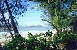
Palm Cove is located in Far North Queensland on the Australian coast. It has a long sandy beach along most of its seafront except for the rocky headland around Buchan Point in the north of the suburb.[3]
Arlington Reef is the closest section of The Great Barrier Reef to Palm Cove being around 30 kilometres (19 mi) offshore. The reef shelters the inshore waters from the Coral Sea swells creating relatively calm waters between the reef and the beach. To the west of Palm Cove is the Macalister Range National Park which is part of the Wet Tropics World Heritage Area.[4][5]
Since Palm Cove is located in a tropical climate, the average summer temperature is between 24 and 33 degrees Celsius; average winter temperature is between 14 and 26 degrees Celsius.[6]
The town of Buchan is within the Palm Cove locality,[7] but the use of the name Buchan has fallen into disuse over the years.[8]
History
Shortly before World War I in 1918, the land that is today Palm Cove was bought by Albert Veivers from Archdeacon Campbell. Archdeacon Campbell had been known as a priest at Cairns church who experimented with bringing different agricultural crops to the Cairns region. Veivers was important in the advancement of Palm Cove by having the first road built. The creation of the road led property values in Palm Cove to increase dramatically, leading to more prosperity for the community. Shortly after World War II, in which Palm Cove was used as a training base for Australian soldiers, the number of people traveling to Palm Cove greatly increased. The opening of the Ramada Reef Resort in 1986 marked the first international hotel chain to be located in Palm Cove and the town has continued to increase in national and international recognition ever since.[9]
At the 2006 census, Palm Cove had a population of 1,215.[10]
Public services
Due to the small size of Palm Cove, the community does not offer many public services of its own. The closest airport to Palm Cove is the Cairns International Airport. The only method of direct transportation to Palm Cove is along the Captain Cook Highway which stretches from Cairns in the south to Mossman in the north. Palm Cove has no schools and children typically go to public or private schools in the surrounding suburbs of Kewarra Beach, Trinity Beach, and Smithfield. Palm Cove does not offer many options for shopping. The closest shopping centre is at Clifton Beach.
Tourism
The major industry for Palm Cove is tourism. Palm Cove is also a tourist destination due to its proximity to the Great Barrier Reef and the Daintree Rainforest. Palm Cove is the location of many resorts and hotels.
Recreation
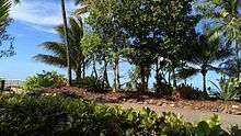
The pristine beaches and palm tree lined paths are used by joggers, walkers and cyclists and netted life guard patrol swimming enclosures offer safe access to the sea all year round. The Palm Cove jetty is one of the regions most popular fishing spots where anglers regularly catch species such as mackerel, Giant Trevally or "G.T's" and shark.
References
- Australian Bureau of Statistics (27 June 2017). "Palm Cove (State Suburb)". 2016 Census QuickStats. Retrieved 23 January 2018.

- "Palm Cove - suburb in Cairns Region (entry 48824)". Queensland Place Names. Queensland Government. Retrieved 29 December 2017.
- "Queensland Globe". State of Queensland. Retrieved 3 June 2019.
- "Macalister Range National Park". National Parks, Sport and Racing. Queensland Government. Archived from the original on 3 April 2016. Retrieved 13 March 2018.
- Jones, Kate (24 June 2010). "Cassowaries the big winners as national parks expanded". The Queensland Cabinet and Ministerial Directory. Queensland Government. Archived from the original on 13 March 2018. Retrieved 13 March 2018.
- "Archived copy". Archived from the original on 6 July 2011. Retrieved 16 November 2010.CS1 maint: archived copy as title (link)
- "Buchan - town in Cairns Region (entry 4865)". Queensland Place Names. Queensland Government. Retrieved 28 December 2017.
- "Palm Cove". Queensland Places. Centre for the Government of Queensland, University of Queensland. Archived from the original on 13 March 2018. Retrieved 13 March 2018.
- "Palm Cove History". www.palmcoveaustralia.com. Archived from the original on 31 May 2013. Retrieved 13 March 2018.
- Australian Bureau of Statistics (25 October 2007). "Palm Cove (Cairns City) (State Suburb)". 2006 Census QuickStats. Retrieved 28 June 2009.
External links
| Wikimedia Commons has media related to Palm Cove, Queensland. |