Cairns North, Queensland
Cairns North is a coastal suburb of Cairns in the Cairns Region, Queensland, Australia.[2] In the 2016 census, Cairns North had a population of 5,191 people.[1]
| Cairns North Cairns, Queensland | |||||||||||||||
|---|---|---|---|---|---|---|---|---|---|---|---|---|---|---|---|
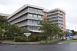 Cairns Hospital on the Esplanade, 2012 | |||||||||||||||
 Cairns North | |||||||||||||||
| Coordinates | 16°54′36″S 145°45′42″E | ||||||||||||||
| Population | 5,191 (2016 census)[1] | ||||||||||||||
| • Density | 811/km2 (2,101/sq mi) | ||||||||||||||
| Postcode(s) | 4870 | ||||||||||||||
| Area | 6.4 km2 (2.5 sq mi) | ||||||||||||||
| LGA(s) | Cairns Region | ||||||||||||||
| State electorate(s) | Cairns | ||||||||||||||
| Federal Division(s) | Leichhardt | ||||||||||||||
| |||||||||||||||
Geography
Cairns North is bounded by the Cairns Airport to the north, the Coral Sea to the east and Lily Creek to the west. As the name suggests, it is immediately north of the Cairns central business district. Highway 1 (part of the main route around the Australian coast) passes through the suburb on Sheridan Street.[3]
The suburb is flat land just above sea level. Parkland and an esplanade separate the developed areas of the suburb from the sea. At high tide there is a small sandy beach but low tide reveals an extensive mudflat.[3]
The suburb has a mix of uses having both permanent and holiday residential (the latter being mostly close to the shore), commercial buildings and community facilities, including a number of schools, Cairns Hospital, the Tobruk Memorial swimming pool and the now closed cemetery in McLeod Street.[3]
History
Edge Hill State School opened in Cairns North on 19 February 1917. It was renamed Cairns North State School in 1939 ( just prior to the opening of a separate Edge Hill State School in neighbouring suburb of Edge Hill in 1940). Cairns North State School closed on 31 December 2004.[4]
Cairns State High School opened on 28 January 1924, having commenced operation as an annex to Cairns Central State School in 1917.[4][5]
Mother of Good Counsel School opened on 29 March 1936 with 19 students, after Father Phelan (an Augustinian priest) saw the need for Catholic education in the area. The school was operated by the Sisters of Mercy.[4][6]
Although Cairns North has a beach, in 1962 concerns about marine stingers in the seawater resulted in the establishment of the Tobruk Memorial swimming pool (not to be confused with the similarly named pool in Townsville).[7]
Population
According to the 2016 census of Population, there were 5,191 people in Cairns North.
- Aboriginal and Torres Strait Islander people made up 7.0% of the population.
- 47.8% of people were born in Australia. The next most common countries of birth were India 4.9%, England 4.1%, New Zealand 3.4% and Japan 2.5%.
- 56.6% of people spoke only English at home. Other languages spoken at home included Punjabi 3.2%, Japanese 2.8% and Mandarin 2.5%.
- The most common response for religion was No Religion at 32.5%.[1]
Heritage listings
Cairns North has a number of heritage-listed sites, including:
- 127–145 McLeod Street: McLeod Street Pioneer Cemetery[8]
- 180 McLeod Street: Herries Private Hospital[9]
- Sheridan Street: Cairns Technical College and High School Building (now Block A of the Cairns State High School)[5]
- 183–185 The Esplanade, Cairns North: Floriana[10]
Amenities
The Cairns Indigenous Art Centre is at 355 Sheridan Street. It is operated by Umi Arts, an Indigenous organisation established in 2005, to preserve and protect the culture of Aboriginal and Torres Strait Islander people.[11][12]
The Cairns branch of the Queensland Country Women's Association meets at 264 Grafton Street, Cairns North.[13]
References
- Australian Bureau of Statistics (27 June 2017). "Cairns North (State Suburb)". 2016 Census QuickStats. Retrieved 18 April 2018.

- "Cairns North (entry 48555)". Queensland Place Names. Queensland Government. Retrieved 7 February 2015.
- "Queensland Globe". State of Queensland. Retrieved 3 October 2017.
- Queensland Family History Society (2010), Queensland schools past and present (Version 1.01 ed.), Queensland Family History Society, ISBN 978-1-921171-26-0
- "Cairns Technical College and High School Building (entry 602834)". Queensland Heritage Register. Queensland Heritage Council. Retrieved 1 August 2014.
- "History". Mother of Good Counsel School. Archived from the original on 3 October 2017. Retrieved 3 October 2017.
- "Cairns". Queensland Places. Centre for the Government of Queensland, University of Queensland. Archived from the original on 4 October 2017. Retrieved 4 October 2017.
- "McLeod Street Pioneer Cemetery (entry 600383)". Queensland Heritage Register. Queensland Heritage Council. Retrieved 7 July 2013.
- "Herries Private Hospital (entry 602137)". Queensland Heritage Register. Queensland Heritage Council. Retrieved 7 July 2013.
- "Floriana (entry 602738)". Queensland Heritage Register. Queensland Heritage Council. Retrieved 7 July 2013.
- "Strengthening Cultural Stories". Archived from the original on 26 April 2018. Retrieved 26 April 2018.
- "UMI Arts - Cairns Arts and Culture Map". cairnsartsandculturemap.com.au. Archived from the original on 26 April 2018. Retrieved 26 April 2018.
- "Branch Locations". Queensland Country Women's Association. Retrieved 26 December 2018.
Further reading
- Cairns North State School (1992), 75th anniversary Cairns North State School 1917-1992, Cairns North State School, retrieved 4 October 2017
- Stanton, Peter (2017), Cairns High : the first hundred years : 1917-2017, Centenary Celebrations Committee, Cairns State High School, ISBN 978-0-646-96596-3
- Nemec, Marie-Claire (2002), Walking through the Mcleod Street Pioneer Cemetery : a history of the cemetery and the pioneers buried under the monuments, M-C. Nemec, ISBN 978-0-9581809-0-0
- Balodis, Midge (2000), Drill till you get blood! : Cairns Hospital 1878-1950, the author, retrieved 4 October 2017
- Bell-Booth, John; Bell-Booth, Christine; Queensland Ambulance Transport Brigade Hospital. Cairns Centre (1966), Queensland Ambulance Transport Brigade Hospital, Cairns Centre : the story of a vital service, Townsville, Qld, retrieved 4 October 2017
External links
![]()