Mount Sheridan, Queensland
Mount Sheridan is a suburb of Cairns in the Cairns Region, Queensland, Australia.[2]
| Mount Sheridan Cairns, Queensland | |||||||||||||||
|---|---|---|---|---|---|---|---|---|---|---|---|---|---|---|---|
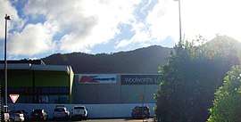 Mount Sheridan Plaza shopping centre | |||||||||||||||
 Mount Sheridan | |||||||||||||||
| Coordinates | 16.9838°S 145.7288°E | ||||||||||||||
| Population | 8,271 (2016 census)[1] | ||||||||||||||
| • Density | 1,165/km2 (3,017/sq mi) | ||||||||||||||
| Postcode(s) | 4868 | ||||||||||||||
| Area | 7.1 km2 (2.7 sq mi) | ||||||||||||||
| Location | 10.6 km (7 mi) south of Cairns City | ||||||||||||||
| LGA(s) | Cairns Region | ||||||||||||||
| State electorate(s) | Mulgrave | ||||||||||||||
| Federal Division(s) | |||||||||||||||
| |||||||||||||||
Geography
The Bruce Highway and the North Coast railway line immediately to its east form the eastern boundary of the suburb.[3]
History
Mount Sheridan is situated in the Yidinji traditional Aboriginal country. [4] The suburb takes its name from the mountain of the same name, which is not located within the suburb but to the west in Lamb Range.
References
- Australian Bureau of Statistics (27 June 2017). "Mount Sheridan (Qld) (State Suburb)". 2016 Census QuickStats. Retrieved 18 April 2018.

- "Mount Sheridan - suburb in Cairns Region (entry 48790)". Queensland Place Names. Queensland Government. Retrieved 5 August 2017.
- "Queensland Globe". State of Queensland. Retrieved 13 September 2017.
- "Indigenous culture and history". Cairns Regional Council. Archived from the original on 9 April 2020. Retrieved 23 June 2020.
This article is issued from Wikipedia. The text is licensed under Creative Commons - Attribution - Sharealike. Additional terms may apply for the media files.