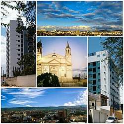
Vitória de Santo Antão
Victory Of St. Antão (em português: Vitória de Santo Antão) is city in the State of Pernambuco, in Brazil. is a Brazilian municipality in the state of Pernambuco, northeastern region of the country. It integrate and Mesoregion of the Pernambuco Mata South Center and the microregion of Vitória de Santo Antão,located 46 kilometers west of the state capital. Even though it is practically within the RMR, metropolitan area of Recife. Its territorial area is of 335,942 km², being 5,717 km² in urban perimeter. In 2016, the Brazilian Institute of Geography and Statistics (IBGE) estimated its population at approximately 137 915 inhabitants, being the tenth most populous city in Pernambuco, the fourth most populous in the interior of the state and the most populous in Zona da Mata. According to the Firjan Municipal Development Index (IFDM), Vitória de Santo Antão was elected the 8th best city to live in Pernambuco. A curiosity: Vitória de Santo Antão, is the only city in the Americas to have St. antão as patron. The municipal headquarters has an average temperature of 23.8 ° C [7] and its predominant native vegetation is Atlantic forest, although much of its green landscape has been replaced by sugarcane monoculture. [8 ] With approximately 87.2% of the population living in the urban area of the municipality, [9] the city had 57 health facilities in 2009. Its Human Development Index is 0.640 and is considered medium. (8°07′S 35°18′W).
St. Antão Victory Municipality of Pernambuco | |
|---|---|
 | |
 Flag  Seal | |
| Nickname(s): Victory | |
| Anthem: Anthem of the City of St. Anthony's Victory | |
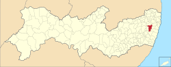 Location in the state of Pernambuco and Brazil | |
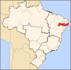
 St. Antão Victory Location in Brazil | |
| Coordinates: 08°07′35″S 35°18′27″W | |
| Country | Brazil |
| Region | Northeast Region |
| State | Pernambuco |
| Government | |
| • Mayor | Mayor: Aglaison Júnior (PSB) |
| Area | |
| • Total | 335.941 km2 (129.708 sq mi) |
| Elevation | 147 m (482 ft) |
| Population (2018 est.[2]) | |
| • Total | 137,915 |
| • Density | 410/km2 (1,100/sq mi) |
| Time zone | UTC -3 |
Geography
- State - Pernambuco
- Region - Zona da mata Pernambucana
- Boundaries - Glória do Goitá and Chã de Alegria (N); Primavera and Escada (S); Pombos (W); Moreno, Cabo de Santo Agostinho and São Lourenço da Mata (E)
- Area - 371.8 km2
- Elevation - 156 m
- Hydrography - Capibaribe and Ipojuca rivers
- Vegetation - Subperenifólia forest
- Climate - Hot tropical and humid
- Annual average temperature - 24.6 c
- Distance to Recife - 45 km
Economy
The main economic activities in Vitoria de Santo Antão are based in commerce, food and beverage industry (including the traditional Pitú cachaça), and primary sector especially sugarcane, lemons and cattle.
References
- "Brazilian Institute of Geography and Statistics" (in Portuguese). 2017. Retrieved 27 March 2019.
2018 Area Total
- "Brazilian Institute of Geography and Statistics" (PDF) (in Portuguese). 2018. Retrieved 6 March 2019.
2018 Estimates of Population
- http://www.ibge.gov.br/home/estatistica/populacao/estimativa2009/POP2009_DOU.pdf IBGE Population 2009 Vitoria de Santo Antao, page 35]
- Vitoria de Santo Antão 2007 GDP IBGE page 32 Archived March 4, 2016, at the Wayback Machine
- PE State site - City by city profile Archived August 4, 2009, at the Wayback Machine
Capital: Recife | ||||||||||||||
| Mesoregion Agreste Pernambucano |
|  | ||||||||||||
| Mesoregion Mata Pernambucana |
| |||||||||||||
| Mesoregion Metropolitana de Recife |
| |||||||||||||
| Mesoregion Sao Francisco Pernambucano |
| |||||||||||||
| Mesoregion Sertao Pernambucano |
| |||||||||||||