Jaboatão dos Guararapes
Jaboatão dos Guararapes (Portuguese pronunciation: [ʒabwaˈtɐ̃w duz ɡwaɾaˈɾapis]) is a city in the state of Pernambuco, Brazil. It is a part of the Recife metro area. The population was 697,636[1] according to the Brazilian Institute of Geography and Statistics (IBGE) in 2018, making it the second most-populous city in the state of Pernambuco and the 27th in Brazil, ahead of major Brazilian state capitals such as Cuiabá and Aracaju. The city is a very important industrial center, hosting companies like Unilever and Coca-Cola. It is bordered by Recife in the North, Cabo de Santo Agostinho on the south, and Mangue forests to the west in Moreno.
Jaboatão dos Guararapes | |
|---|---|
City | |
| City of Jaboatão dos Guararapes | |
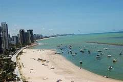
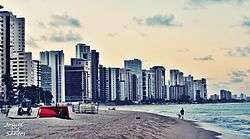 View of the city and Piedade Beach | |
 Flag  Seal | |
| Nickname(s): "Nation's Birthplace" | |
| Motto(s): "For Nation's Unity" | |
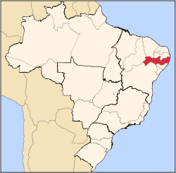
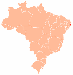 Location of Jaboatão dos Guararapes | |
| Coordinates: 8°06′44″S 35°00′56″W | |
| Country | Brazil |
| Region | Northeast |
| State | |
| Government | |
| • Mayor | Anderson Ferreira (PR) |
| Area | |
| • Total | 256.08 km2 (98.87 sq mi) |
| Elevation | 10 m (33 ft) |
| Population (2018 est.[1]) | |
| • Total | 697,636 |
| • Density | 2,700/km2 (7,100/sq mi) |
| Time zone | UTC-4 (UTC-4) |
| • Summer (DST) | UTC-4 (UTC-4) |
| Postal Code | 54000-000 |
| Area code(s) | +55 81 |
| GDP | BR$11.952 billion 2014[2] |
| GDP per capita | BR$17 691.00 |
| Website | pjg |
Geography
The city is located at around 8°6′46″S 35°0′54″W, just south of Recife. It has three urban beaches (Piedade, Candeias and Barra de Jangada). Some of the main neighborhoods are Candeias, Cavaleiro, Piedade, Jardim Piedade and Barra de Jangada.
- State – Pernambuco
- Region – RMR (Recife)
- Boundaries – Sao Lourenco da Mata and Recife (N), Cabo de Santo Agostinho (S ), Moreno (W), Atlantic Ocean (E)
- Area – 256.073 km2 (99 sq mi)
- Elevation – 76 m (247 ft)
- Hydrography – small coaster rivers
- Rivers – Jaboatão, Gurjaú and Jordão
- Urban Beaches – Piedade, Candeias and Barra de Jangada
- Vegetation – Atlantic forest, Mangal and Sugarcane
- Climate – Hot tropical and humid
- Annual average temperature – 28 c
- Metro – Recife Metro
- Main roads – BR 101, BR 232, BR-408, PE-007, PE-008 (Batalha's Road) and PE-017 (Axis of Integration)
- Main ways – Bernado Vieira de Melo Avenue, Beira-Mar (Seaside) Avenue, Curcurana's Road, Manoel Rabelo's Avenue, Castelo Branco's Avenue, Barreto de Menezes Avenue, Ayrton Senna's Avenue, Setúbal Channel Avenue, President Kennedy's Avenue, Aniceto Varejão Street and Arão Lins de Andrade Street
History
The unclassified extinct Arapoá language was spoken around Jaboatão.[3]
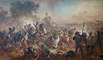
The city of Jaboatão dos Guararapes was founded on 4 May 1593 by Bento Luiz Figueira, the third owner of Engenho São João Baptista. The Second Battle of Guararapes occurred in the city and was one of the most important battles in Brazil's history, in which the people from Pernambuco defeated and expelled the Dutch from the State. This battle was an important event that led to the creation of the Brazilian Army. In 1873 it ascended to village status, and in 1884 after being split up with Olinda it ascended to city status.
Demographics
In 2009, the city population estimated by IGBE was 687,688, however, local politicians criticized the research claiming that there were more people living in the city than were on the census. Notwithstanding, IBGE did not redo the survey. Its population makes it the 2nd most populous city in the state of Pernambuco, 9th in the Northeast region and the 26th in the whole country.
Economy
The main economic activities in Jaboatao dos Guararapes are based in tourism, commerce, beverage industry and transportation industry.
See also
- Pernambuco museums
- Pernambuco beaches
References
- "Brazilian Institute of Geography and Statistics" (PDF) (in Portuguese). 2018. Retrieved March 6, 2019.
2018 Estimates of Population
- "Jaboatão dos Guararapes – IBGE Cidades". IBGE. Retrieved December 14, 2016.
- Loukotka, Čestmír (1968). Classification of South American Indian languages. Los Angeles: UCLA Latin American Center.
- Jaboatao dos Guararapes 2006 GDP, IBGE pág 30 Archived October 3, 2011, at the Wayback Machine
- PE State site – City by city profile
External links
- (in English) City Guide
Capital: Recife | ||||||||||||||
| Mesoregion Agreste Pernambucano |
|  | ||||||||||||
| Mesoregion Mata Pernambucana |
| |||||||||||||
| Mesoregion Metropolitana de Recife |
| |||||||||||||
| Mesoregion Sao Francisco Pernambucano |
| |||||||||||||
| Mesoregion Sertao Pernambucano |
| |||||||||||||