Manari, Pernambuco
Manari is a city established in 1997 in the state of Pernambuco, Brazil. The population in 2009, according to the Brazilian Institute of Geography and Statistics, was 18093[1] and the area is 406.64 km². In 2000, Manari had the lowest HDI of any municipality in the state.[2]
Manari | |
|---|---|
 Flag | |
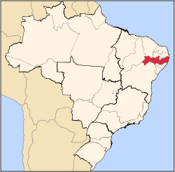
 Manari Manari located in Brazil map | |
| Coordinates: 8°57′50″S 37°37′40″W | |
| Country | |
| State | Pernambuco |
| Region | Sertão |
| City | 1997 |
| Area | |
| • Total | 406.64 km2 (157.00 sq mi) |
| Elevation | 570 m (1,870 ft) |
| Population (2009) | |
| • Total | 18,093 |
| Average Temperature | 23.5 °C (74.3 °F) |
Geography
- State - Pernambuco
- Region - Sertão Pernambucano
- Boundaries - Ibimirim (N); Alagoas state (S); Itaíba (E); Inajá (W)
- Area - 406.64 km²
- Elevation - 570 m
- Hydrography - Moxotó River and Ipanema River
- Vegetation - Caatinga Hiperxerófila
- Climate - semi-arid, hot and dry
- Annual average temperature - 23.5 c
- Distance to Recife - 376 km
Economy
The main economic activities in Manari are based in agribusiness, especially the raising of sheep, goats, cattle, and plantations of corn, beans and manioc.
References
- IBGE Population 2009 Manari, page 33
- Frigoletto Archived 2011-07-06 at the Wayback Machine
- Manari 2007 GDP IBGE page 30 Archived 2016-03-04 at the Wayback Machine
- PE State site - City by city profile
External links
- http://www.contasnacional.com.br/pe/pmmanari
- http://www.ferias.tur.br/informacoes/5337/manari-pe.html
Capital: Recife | ||||||||||||||
| Mesoregion Agreste Pernambucano |
|  | ||||||||||||
| Mesoregion Mata Pernambucana |
| |||||||||||||
| Mesoregion Metropolitana de Recife |
| |||||||||||||
| Mesoregion Sao Francisco Pernambucano |
| |||||||||||||
| Mesoregion Sertao Pernambucano |
| |||||||||||||
This article is issued from Wikipedia. The text is licensed under Creative Commons - Attribution - Sharealike. Additional terms may apply for the media files.