Limoeiro
Limoeiro | |
|---|---|
 Limoeiro Overview | |
 Flag  Seal | |
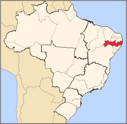
 Limoeiro Limoeiro located in Brazil map | |
| Coordinates: 7°52′30″S 35°27′00″W | |
| Country | |
| State | Pernambuco |
| Region | Agreste |
| Area | |
| • Total | 269.97 km2 (104.24 sq mi) |
| Elevation | 138 m (453 ft) |
| Average Temperature | 25.1 °C (77.2 °F) |
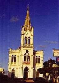
Limoeiro's principal church
Limoeiro is a city in Pernambuco, Brazil.
Geography
- State - Pernambuco
- Region - Agreste Pernambucano
- Boundaries - Vicência (N); Passira and Feira Nova (S); Carpina, Lagoa do Carro and Buenos Aires (E); Bom Jardim, Salgadinho and João Alfredo (W)
- Area - 269.97 km2
- Elevation - 138 m
- Hydrography - Capibaribe and Goiana rivers
- Vegetation - Caducifólia forest
- Climate - hot, tropical, and humid
- Annual average temperature - 25.1 c
- Distance to Recife - 91 km
Economy
The main economic activities in Limoeiro are based in industry, commerce, tourism and agribusiness, especially plantations of bananas and sugarcane, and the raising of cattle, goats, sheep, pigs and chickens.
References
- http://www.ibge.gov.br/home/estatistica/populacao/estimativa2009/POP2009_DOU.pdf IBGE Population 2009 (Limoeiro, page 33)
- Limoeiro 2007 GDP IBGE page 30 Archived 2016-03-04 at the Wayback Machine
- PE State site - City by city profile
External links

Capital: Recife | ||||||||||||||
| Mesoregion Agreste Pernambucano |
|  | ||||||||||||
| Mesoregion Mata Pernambucana |
| |||||||||||||
| Mesoregion Metropolitana de Recife |
| |||||||||||||
| Mesoregion Sao Francisco Pernambucano |
| |||||||||||||
| Mesoregion Sertao Pernambucano |
| |||||||||||||
This article is issued from Wikipedia. The text is licensed under Creative Commons - Attribution - Sharealike. Additional terms may apply for the media files.