Buner District
Buner District (Pashto: بونیر ولسوالۍ, Urdu: ضِلع بونیر) is a district in Malakand Division of Khyber Pakhtunkhwa province in Pakistan. Before becoming a district in 1991, it was a tehsil within Swat District.[4]:1 The predominant language is Pashto, which is spoken natively by 96.6% of the population.[4]:33
Buner | |
|---|---|
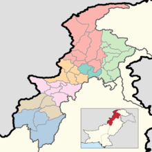
 Location in the province of Khyber Pakhtunkhwa | |
| Country | Pakistan |
| Province | Khyber Pakhtunkhwa |
| Headquarters | Daggar[1] |
| Government | |
| • District Commissioner | Shafi ullah |
| Area | |
| • Total | 1,865 km2 (720 sq mi) |
| Population | |
| • Total | 897,319 |
| • Density | 480/km2 (1,200/sq mi) |
| Time zone | UTC+5 (PST) |
| Number of tehsils | 4 |
| Number of Union Councils | 27[3] |
History

The Buner Valley lies on the Peshawar valley border of the Khyber Pakhtunkhwa. It is a small mountain valley, dotted with villages and divided into four sub-divisions. The Mora Hills and the Ilam range divide it from the Swat Valley, the Sinawar range from Yusafzai, the Guru mountains from the Mardan Valley, and the Duma range from the Puran Valley.[5] During the 19th century the inhabitants rose twice against the British, but submitted in 1897.[6]
In April 2009, the Taliban seized control of Buner, after a brief battle with local residents. Strict rules were reportedly being enforced, including the elimination of video stores, bans on cutting beards, and the prevention of women from appearing in many public places.[7] On 29 April the government responded to the Taliban by sending the army to the region and dropping parachutists by helicopter.[8] By the end of May 2009, almost all of Buner was cleared of the Taliban.[9]
Education
The first public sector university, University of Buner was founded in 2017. There are many other public and private sector university campuses in Buner now, Abdul Wali Khan University, Government Degree College Daggar and many other.
Administration
Buner Tehsils
Buner District is currently subdivided into 6 Tehsils.
- Daggar
- Gagra
- Khudu Khel
- Chamla
- Chagharzai
- Gadezai
- Jowar
- Bampokha
- Kingergali
- Nanser
- Bazargai
- Leganai
- Cherai
- Katkala
National assembly
This district is represented by one elected MNA (Member of National Assembly) in Pakistan National Assembly. Its constituency is NA-28.[10]
| Election | Member | Party |
|---|---|---|
| 2002 | Sher Akbar Khan | PPP (S) |
| 2008 | Istiqbal Khan | ANP |
| 2013 | Sher Akbar Khan | JI |
| 2018 | Sher Akbar Khan | PTI |
Provincial assembly
The district has three constituencies in the Provincial Assembly of Khyber Pakhtunkhwa[11] and one in the National Assembly of Pakistan.
| Constituency | MPA | Party |
|---|---|---|
| PK-20 (Buner-I) | PTI | |
| PK-21 (Buner-II) | ||
| PK-22 (Buner-III) |
See also
- Khyber Pakhtunkhwa
- Rustam, Mardan
- Mardan
- Swat
- University of Buner
References
- "Uncertainty rules Pakistan's Buner district" Archived 2014-07-14 at the Wayback Machine, Radio Nertherlands Worldwide
- "DISTRICT AND TEHSIL LEVEL POPULATION SUMMARY WITH REGION BREAKUP: KHYBER PAKHTUNKHWA" (PDF). Pakistan Bureau of Statistics. 2018-01-03. Archived from the original (PDF) on 2018-04-24. Retrieved 2018-04-23.
- "Village/Neighbourhood Council". lgkp.gov.pk.
- 1998 District Census report of Buner. Census publication. 98. Islamabad: Population Census Organization, Statistics Division, Government of Pakistan. 2000.
-

- Chisholm 1911.
- Taliban Exert Influence in Pakistan: April 21, 2009
- Pakistani forces seize main town of Buner district from Taliban
- "90% Buner Cleared: May 27, 2009". Archived from the original on 2012-03-18. Retrieved 2009-06-12.
- http://ecp.gov.pk/GE.aspx
- Constituencies and MPAs – Website of the Provincial Assembly of the NWFP Archived April 22, 2009, at the Wayback Machine
External links
- Gaju Khan Yusufzai
- Yusufzai at Khyber.org
Administrative divisions of Buner District | ||
|---|---|---|
| Capital | ||
| Tehsils |
| |
| Union councils | ||