Bahrain, Pakistan
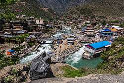
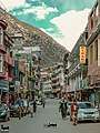
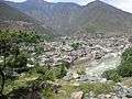
Bahrain (Torwali/Pashto: بحرین; also spelled Behrain) is a town located in Swat District of Khyber Pakhtunkhwa, Pakistan, 60 km North of Mingora at an elevation of 4700 ft on the right bank of the Swat river. It is named Bahrain (lit. "two rivers") due to its location at the confluence of the Daral and Swat rivers. It is known for its riverside tourist resorts, local handicrafts, and its view of the merging of the Daral and Swat Rivers. It also serves as a base camp for the trail that leads to the Daral & Saidgai lakes.
Bahrain | |
|---|---|
 | |
 Bahrain Bahrain Valley  Bahrain Bahrain (Pakistan) | |
| Coordinates: 35.2075°N 72.5456°E | |
| Country | |
| Province | Khyber Pakhtunkhwa |
| District | Swat |
| Elevation | 1,435 m (4,708 ft) |
| Population | |
| • Total | 102,253 |
| Time zone | UTC+5 (PST) |
Climate
With a mild and generally warm and temperate climate, Bahrain has a humid subtropical climate (Cfa) under the Köppen climate classification. The average temperature in Bahrain is 16.6 °C or 61.9 °F, while the annual precipitation averages 866 millimetres or 34.09 inches. November is the driest month with 21 millimetres or 0.83 inches of precipitation, while March, the wettest month, has an average precipitation of 120 millimetres or 4.72 inches.
July is the hottest month of the year with an average temperature of 27.0 °C or 80.6 °F. The coldest month January has an average temperature of 4.8 °C or 40.6 °F.
| Climate data for Bahrain | |||||||||||||
|---|---|---|---|---|---|---|---|---|---|---|---|---|---|
| Month | Jan | Feb | Mar | Apr | May | Jun | Jul | Aug | Sep | Oct | Nov | Dec | Year |
| Average high °C (°F) | 9.1 (48.4) |
11.1 (52.0) |
16.3 (61.3) |
21.8 (71.2) |
27.2 (81.0) |
33.3 (91.9) |
33.5 (92.3) |
32.2 (90.0) |
29.6 (85.3) |
24.7 (76.5) |
18.7 (65.7) |
11.7 (53.1) |
22.4 (72.4) |
| Daily mean °C (°F) | 4.8 (40.6) |
6.5 (43.7) |
11.1 (52.0) |
16.1 (61.0) |
20.8 (69.4) |
26.2 (79.2) |
27.0 (80.6) |
26.0 (78.8) |
23.1 (73.6) |
17.9 (64.2) |
12.5 (54.5) |
7.0 (44.6) |
16.6 (61.9) |
| Average low °C (°F) | 0.6 (33.1) |
2.0 (35.6) |
5.9 (42.6) |
10.4 (50.7) |
14.5 (58.1) |
19.2 (66.6) |
20.5 (68.9) |
19.9 (67.8) |
16.6 (61.9) |
11.2 (52.2) |
6.4 (43.5) |
2.4 (36.3) |
10.8 (51.4) |
| Average rainfall mm (inches) | 69 (2.7) |
92 (3.6) |
120 (4.7) |
107 (4.2) |
64 (2.5) |
40 (1.6) |
109 (4.3) |
109 (4.3) |
61 (2.4) |
33 (1.3) |
21 (0.8) |
41 (1.6) |
866 (34) |
| Source: Climate-Data.org[2] | |||||||||||||
Gallery
See also
- Marghazar
- Miandam
- Malam Jabba
- Madyan
- Kalam
- Gabina Jabba
- Bashigram Lake
- Swat District
References
- "POPULATION AND HOUSEHOLD DETAIL FROM BLOCK TO DISTRICT LEVEL: KHYBER PAKHTUNKHWA" (PDF). Pakistan Bureau of Statistics. 3 January 2018. Archived from the original (PDF) on 17 April 2018. Retrieved 23 April 2018.
- "Climate: Bahrain – Climate-Data.org". Retrieved 15 September 2016.
| Wikimedia Commons has media related to Bahrain (Pakistan). |
External links
- Khyber-Pakhtunkhwa Government website section on Lower Dir and neighboring places
- United Nations
- https://www.hifzatravelgroup.pk/
- http://www.swatvalley.com
- http://www.khpalswat.com
- http://www.valleyswat.net
- https://ibtswat.academia.edu/