Suldal
Suldal is a municipality in the northeast corner of Rogaland county, Norway. It is located in the traditional district of Ryfylke. Since 1965, the administrative centre of Suldal is the village of Sand i Ryfylke (prior to that it was the village of Suldalsosen). Other villages in Suldal include Hålandsosen, Jelsa, Marvik, Nesflaten, and Suldalsosen.
Suldal kommune | |
|---|---|
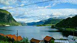
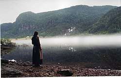 View of the lake Suldalsvatnet | |
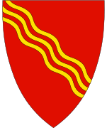 Coat of arms  Rogaland within Norway | |
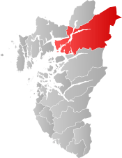 Suldal within Rogaland | |
| Coordinates: 59°28′06″N 06°29′59″E | |
| Country | Norway |
| County | Rogaland |
| District | Ryfylke |
| Administrative centre | Sand |
| Government | |
| • Mayor (2015) | Gerd Helen Bø (Sp) |
| Area | |
| • Total | 1,736.89 km2 (670.62 sq mi) |
| • Land | 1,582.80 km2 (611.12 sq mi) |
| • Water | 154.09 km2 (59.49 sq mi) |
| Area rank | 39 in Norway |
| Population (2017) | |
| • Total | 3,853 |
| • Rank | 235 in Norway |
| • Density | 2.4/km2 (6/sq mi) |
| • Change (10 years) | -0.5% |
| Demonym(s) | Suldøl[1] |
| Time zone | UTC+01:00 (CET) |
| • Summer (DST) | UTC+02:00 (CEST) |
| ISO 3166 code | NO-1134 |
| Official language form | Nynorsk[2] |
| Website | www |
The 1,737-square-kilometre (671 sq mi) municipality is the 39th largest by area out of the 422 municipalities in Norway. Suldal is the 235th most populous municipality in Norway with a population of 3,853. The municipality's population density is 2.4 inhabitants per square kilometre (6.2/sq mi) and its population has decreased by 0.5% over the last decade.[3]
General information
.jpg)
The parish of Suledal was established as a municipality on 1 January 1838 (see formannskapsdistrikt). In 1842, the northern district of the municipality (population: 1,584) was separated to become the new municipality of Søvde. This left Suldal with 2,030 residents. During the 1960s, there were many municipal mergers across Norway due to the work of the Schei Committee. On 1 January 1965, Suldal (population: 1,412) was merged with the neighboring municipalities of Sand (population: 1,135) and Erfjord (population: 610) as well as all of the municipality of Jelsa except for the parts on the island of Ombo (population: 928) and the parts of Imsland municipality located south of the Vindafjorden (population: 61). On 1 January 1978, the parts of Vikedal municipality located southeast of the Vindafjorden on the Ropeid peninsula (population: 13) was transferred to Suldal.[4]
Name
The Old Norse form of the name was Súladalr. The first element is probably the plural genitive case of súla which means "pillar" or "column" (and then referring to the mountain pass Suldalsporten) and the last element is dalr which means "valley" or "dale". Before 1891, the name was written "Suledal".[5]
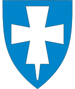
Coat-of-arms
The coat-of-arms is from modern times; they were granted on 11 March 1976. The arms show three wavy, yellow lines in bend on a red background. The lines represent the local river Suldalslågen which runs through the municipality.[6]
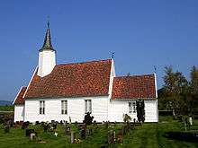
Churches
The Church of Norway has four parishes (sokn) within the municipality of Suldal. It is part of the Ryfylke deanery in the Diocese of Stavanger.
| Parish (Sokn) | Church Name | Location of the Church | Year Built |
|---|---|---|---|
| Erfjord | Erfjord Church | Hålandsosen | 1877 |
| Jelsa | Jelsa Church | Jelsa | 1647 |
| Sand | Sand Church | Sand | 1853 |
| Marvik Chapel | Marvik | 1920 | |
| Suldal | Suldal Church | Suldalsosen | 1852 |
| Nesflaten Chapel | Nesflaten | 1853 |
History
The area that is now Suldal municipality has a long history of trade connections to the nearby valley regions to the north and east. The main mountain plateau trade route led east from Suldal municipality over the plateau to the nearby Setesdal valley in Bykle municipality in Aust-Agder county. Another route led north from Suldal in Rogaland county through the Røldal area in Hordaland county, and then east into Vinje municipality in Telemark county. There has also been found Viking artefacts and graves in Suldal.
Geography
At 1,736 square kilometres (670 sq mi), Suldal is the largest municipality in Rogaland county. The municipality borders three counties: Hordaland (north), Telemark (northeast), and Aust-Agder (east). To the north, Suldal is bordered by Sauda and Odda municipalities, in the east by Vinje and Bykle, in the south by Hjelmeland, and in the west by Vindafjord. Across the Jelsafjorden and Vindafjorden lie the municipalities of Finnøy and Tysvær.
The mountain Kistenuten is located at the triple border point of Rogaland, Hordaland and Telemark.[7] Other mountains in Suldal are Vassdalseggi, the highest mountain in Rogaland, Trollaskeinuten, Snønuten, Mælen, Knoda, Fitjanuten, Leirnuten, Kaldafjellet, Simlenuten, Steinkilenuten, and Raudberga, all reaching above 1,400 metres (4,600 ft) m.a.s.l.[8]
The Sandsfjorden and Hylsfjorden lie within Suldal, as does lake Suldalsvatnet. The Saudafjorden lies partially within the boundary of Suldal. The Erfjorden and the lakes Blåsjø, Holmavatnet, and Holmevatnet also lie on the boundary of Suldal.
Economy
The Ulla-Førre project of building huge hydroelectric dams in the mountains was initiated in the 1960s. At times, the project employed over a thousand people. The finished hydroelectric complex has a total capacity of approximately 2,100 megawatts (2,800,000 hp) and produces about 4.8 terawatt-hours (17 PJ) yearly.
Government
All municipalities in Norway, including Suldal, are responsible for primary education (through 10th grade), outpatient health services, senior citizen services, unemployment and other social services, zoning, economic development, and municipal roads. The municipality is governed by a municipal council of elected representatives, which in turn elect a mayor.
Municipal council
The municipal council (Kommunestyre) of Suldal is made up of 19 representatives that are elected to four year terms. Currently, the party breakdown is as follows:[9]
| Party Name (in Nynorsk) | Number of representatives | |
|---|---|---|
| Labour Party (Arbeidarpartiet) | 3 | |
| Conservative Party (Høgre) | 2 | |
| Christian Democratic Party (Kristeleg Folkeparti) | 2 | |
| Centre Party (Senterpartiet) | 7 | |
| Socialist Left Party (Sosialistisk Venstreparti) | 2 | |
| Liberal Party (Venstre) | 3 | |
| Total number of members: | 19 | |
References
- "Navn på steder og personer: Innbyggjarnamn" (in Norwegian). Språkrådet.
- "Forskrift om målvedtak i kommunar og fylkeskommunar" (in Norwegian). Lovdata.no.
- Statistisk sentralbyrå (2017). "Table: 06913: Population 1 January and population changes during the calendar year (M)" (in Norwegian). Retrieved 2017-11-02.
- Jukvam, Dag (1999). "Historisk oversikt over endringer i kommune- og fylkesinndelingen" (PDF) (in Norwegian). Statistisk sentralbyrå.
- Rygh, Oluf (1915). Norske gaardnavne: Stavanger amt (in Norwegian) (10 ed.). Kristiania, Norge: W. C. Fabritius & sønners bogtrikkeri. p. 363.
- "Civic heraldry of Norway - Norske Kommunevåpen". Heraldry of the World. Retrieved 2015-05-26.
- Godal, Anne Marit (ed.). "Ryfylkeheiane". Store norske leksikon (in Norwegian). Norsk nettleksikon. Retrieved 15 May 2013.
- Lauritzen, Per Roger, ed. (2009). Norsk Fjelleksikon (in Norwegian). Arendal: Friluftsforlaget. ISBN 978-82-91-49547-7.
- "Table: 04813: Members of the local councils, by party/electoral list at the Municipal Council election (M)" (in Norwegian). Statistics Norway. 2015.
External links


- Municipal fact sheet from Statistics Norway (in Norwegian)
- Map hiking
- Ryfylke tourist bureau
 |
|  | |||||||||||||||||||||||||
||