Tysvær
Tysvær is a municipality in Rogaland county, Norway. It is part of the Haugalandet region. The municipality is located on the Haugalandet peninsula on the northern side of the Boknafjorden, just east of the towns of Kopervik and Haugesund. The administrative centre of the municipality is the village of Aksdal. Other villages in the municipality include Dueland, Førre, Grinde, Hervik, Hindaråvåg, Nedstrand, Skjoldastraumen, Susort, Tysvær, and Yrke.
Tysvær kommune | |
|---|---|
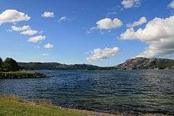 View of the lake Aksdalsvatnet | |
 Coat of arms  Rogaland within Norway | |
 Tysvær within Rogaland | |
| Coordinates: 59°21′42″N 05°32′34″E | |
| Country | Norway |
| County | Rogaland |
| District | Haugaland |
| Administrative centre | Aksdal |
| Government | |
| • Mayor (2015) | Sigmund Lier (Ap) |
| Area | |
| • Total | 425.41 km2 (164.25 sq mi) |
| • Land | 399.78 km2 (154.36 sq mi) |
| • Water | 25.63 km2 (9.90 sq mi) |
| Area rank | 232 in Norway |
| Population (2017) | |
| • Total | 11,041 |
| • Rank | 105 in Norway |
| • Density | 27.6/km2 (71/sq mi) |
| • Change (10 years) | 16.1% |
| Demonym(s) | Tysværbu[1] |
| Time zone | UTC+01:00 (CET) |
| • Summer (DST) | UTC+02:00 (CEST) |
| ISO 3166 code | NO-1146 |
| Official language form | Nynorsk[2] |
| Website | www |
The European route E39 highway and European route E134 highways traverse the municipality with their junction located at Aksdal in Tysvær. The Frekasund Bridge on the E39 highway connects the mainland of Tysvær to the island municipality of Bokn to the south. The Karmøy Tunnel connects Tysvær to the town of Kopervik in neighboring Karmøy municipality.
The 425-square-kilometre (164 sq mi) municipality is the 232nd largest by area out of the 422 municipalities in Norway. Tysvær is the 105th most populous municipality in Norway with a population of 11,041. The municipality's population density is 27.6 inhabitants per square kilometre (71/sq mi) and its population has increased by 16.1% over the last decade.[3]
General information
The municipality of Tysvær was established in 1849 when it was separated from the large municipality of Skjold. Initially, the municipality had a population of 2,058. During the 1960s, there were many municipal mergers across Norway due to the work of the Schei Committee. On 1 January 1965, the following areas were merged into a newly enlarged municipality of Tysvær:
- the old municipality of Tysvær (population: 1,862)
- the municipality of Nedstrand (population: 1,200)
- the Gismarvik, Førre, and Stegaberg areas of Avaldsnes municipality (population: 994)
- the Grinde, Dueland, and Yrkje areas of Skjold municipality (population: 1,133)
- the Breidal and Stølsvik farms from Vats municipality (population: 16)
- the Hapnes and Dokskar farms from Vikedal municipality (population: 2).
On 1 January 1969, the small Sponevik farm area (population: 6), just north of the village of Skjoldastraumen, was transferred from the neighboring Vindafjord municipality to Tysvær.[4]
Name
The municipality (originally the parish) is named after the old Tysvær farm (Old Norse: Teitsfjörðr), since the first Tysvær Church was built there. The first element is the genitive case of the old male name Teitr and the last element is fjörðr which means "fjord".[5]
Coat of arms
The coat of arms is from modern times; they were granted on 3 February 1984. The arms show a silver heron on a blue background. The heron was chosen as a symbol for the municipality since there are several large colonies of herons in the municipality.[6]
Churches
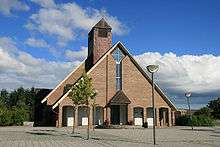
The Church of Norway has three parishes (sokn) within the municipality of Tysvær. It is part of the Haugaland deanery in the Diocese of Stavanger.
| Parish (Sokn) | Church Name | Location of the Church | Year Built |
|---|---|---|---|
| Førresfjorden | Aksdal Church | Aksdal | 1995 |
| Førre Church | Førre | 1893 | |
| Nedstrand | Nedstrand Church | Hindaråvåg | 1868 |
| Skjoldastraumen Church | Skjoldastraumen | 1910 | |
| Tysvær | Tysvær Church | Tysværvåg | 1852 |
Geography
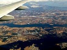
The municipality lies on the northern shore of the Boknafjorden, with the Skjoldafjorden and Vindafjorden both partially located within the municipality. The island of Borgøy lies in the middle of the Skjoldafjorden in Tysvær.
The lake Aksdalsvatnet is the largest lake in the municipality. Another notable lake is Stakkastadvatnet, which lies on the Haugesund-Tysvær municipal border.
Tysvær has a number of scenic walks including Heggelifjellet and Kvinnesland, the source of the name Kvindesland.
Economy
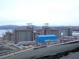
The Kårstø industrial site is located along the shores of the Boknafjorden in southwestern Tysvær. The site has many natural gas-related facilities including the Kårstø Power Station.
Government
All municipalities in Norway, including Tysvær, are responsible for primary education (through 10th grade), outpatient health services, senior citizen services, unemployment and other social services, zoning, economic development, and municipal roads. The municipality is governed by a municipal council of elected representatives, which in turn elect a mayor.
Municipal council
The municipal council (Kommunestyre) of Tysvær is made up of 29 representatives that are elected to four year terms. Currently, the party breakdown is as follows:[7]
| Party Name (in Nynorsk) | Number of representatives | |
|---|---|---|
| Labour Party (Arbeidarpartiet) | 10 | |
| Progress Party (Framstegspartiet) | 4 | |
| Conservative Party (Høgre) | 9 | |
| Christian Democratic Party (Kristeleg Folkeparti) | 4 | |
| Centre Party (Senterpartiet) | 4 | |
| Liberal Party (Venstre) | 1 | |
| Total number of members: | 29 | |
Notable residents
- Cleng Peerson, leader of the first group of Norwegians who emigrated to the United States
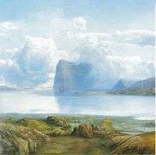
- Lars Hertervig, a landscape painter
- Asbjørn Kloster, leader of the Norwegian temperance movement
- Lido, a hip hop artist, rapper, producer, and songwriter
References
- "Navn på steder og personer: Innbyggjarnamn" (in Norwegian). Språkrådet.
- "Forskrift om målvedtak i kommunar og fylkeskommunar" (in Norwegian). Lovdata.no.
- Statistisk sentralbyrå (2017). "Table: 06913: Population 1 January and population changes during the calendar year (M)" (in Norwegian). Retrieved 2017-11-04.
- Jukvam, Dag (1999). "Historisk oversikt over endringer i kommune- og fylkesinndelingen" (PDF) (in Norwegian). Statistisk sentralbyrå.
- Rygh, Oluf (1915). Norske gaardnavne: Stavanger amt (in Norwegian) (10 ed.). Kristiania, Norge: W. C. Fabritius & sønners bogtrikkeri. p. 421.
- "Civic heraldry of Norway - Norske Kommunevåpen". Heraldry of the World. Retrieved 2015-09-24.
- "Table: 04813: Members of the local councils, by party/electoral list at the Municipal Council election (M)" (in Norwegian). Statistics Norway. 2015.
External links


- Municipal fact sheet from Statistics Norway (in Norwegian)
 |
|  | |||||||||||||||||||||||||
||