Gjesdal
Gjesdal is a municipality in Rogaland county, Norway. It is located in the traditional district of Jæren. The administrative centre of the municipality is the village of Ålgård. Other villages in Gjesdal include Dirdal, Frafjord, Gilja, Gjesdal, and Oltedal. The municipality lies about 25 kilometres (16 mi) to the southwest of the city of Stavanger in southwestern Norway.[3]
Gjesdal kommune Gjestal (historic) | |
|---|---|
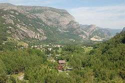
.jpg) View of the Gjesdal landscape | |
 Coat of arms  Rogaland within Norway | |
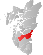 Gjesdal within Rogaland | |
| Coordinates: 58°46′55″N 06°00′31″E | |
| Country | Norway |
| County | Rogaland |
| District | Jæren |
| Administrative centre | Ålgård |
| Government | |
| • Mayor (2013) | Frode Fjeldsbø (Ap) |
| Area | |
| • Total | 617.98 km2 (238.60 sq mi) |
| • Land | 558.20 km2 (215.52 sq mi) |
| • Water | 59.78 km2 (23.08 sq mi) |
| Area rank | 182 in Norway |
| Population (2017) | |
| • Total | 11,902 |
| • Rank | 97 in Norway |
| • Density | 21.3/km2 (55/sq mi) |
| • Change (10 years) | 23.7% |
| Demonym(s) | Gjesdalbu[1] |
| Time zone | UTC+01:00 (CET) |
| • Summer (DST) | UTC+02:00 (CEST) |
| ISO 3166 code | NO-1122 |
| Official language form | Neutral[2] |
| Website | www |
The European route E39 highway runs through the western side of the municipality. On the east side of the municipality, the Frafjord Tunnel connects the Frafjord valley with the rest of the municipality.
The 618-square-kilometre (239 sq mi) municipality is the 182nd largest by area out of the 422 municipalities in Norway. Gjesdal is the 97th most populous municipality in Norway with a population of 11,902. The municipality's population density is 21.3 inhabitants per square kilometre (55/sq mi) and its population has increased by 23.7% over the last decade.[4]
General information

Name
The municipality (originally the parish) is named after the old Gjesdal farm (Old Norse: Gesdalir), since the first Gjesdal Church was built there. The first element is probably an old river name and the last element is the plural form of dalr which means "valley" or "dale".[5]
Before 1889, the name was written Gjæsdal, which is the Danish spelling. During the period from 1889-1917 it was spelled Gjesdal (Norwegian language version). Then starting in 1918, it was spelled Gjestal after the pronunciation of the local dialect (the d in dal is pronounced t because of the voiceless consonant s in front). In 1964, the spelling was changed back to the etymologically correct form of Gjesdal.[6]
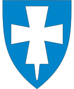
Coat-of-arms
The coat-of-arms is from modern times. They were granted on 15 March 1985. The arms show a white sheep's head on a blue background. The sheet was chosen as a symbol because sheep breeding and wool manufacturing have both been important throughout the history of Gjesdal. The wool industry was centered in the village of Ålgård where wool, textile, and clothing businesses have thrived.[7]
Churches
The Church of Norway has two parishes (sokn) within the municipality of Gjesdal. It is part of the Jæren deanery in the Diocese of Stavanger.
| Parish (Sokn) | Church Name | Location of the Church | Year Built |
|---|---|---|---|
| Gjesdal | Dirdal Church | Dirdal | 1903 |
| Gjesdal Church | Gjesdal | 1848 | |
| Oltedal Church | Oltedal | 2002 | |
| Ålgård | Ålgård Church | Ålgård | 2015 |
| Old Ålgård Church | Ålgård | 1917 |
History
The parish of Gjæsdal was established as a municipality in 1838 (see formannskapsdistrikt). It originally was much smaller than it is today, centered on the Gjesdalen valley in the western part of the present-day municipality. During the 1960s, there were many municipal mergers across Norway due to the work of the Schei Committee. On 1 January 1965 several areas were merged to form a much larger municipality of Gjesdal:[8]
- the original municipality of Gjesdal (population: 3,353)
- the Nedre Maudal area in Bjerkreim municipality (population: 40)
- the Oltesvik area along the Høgsfjorden in Høle municipality (population: 37)
- the parts of Forsand municipality south and east of the Frafjorden including Dirdal, Frafjord, Byrkjedal, Øvre Maudal, and Østabødal (population: 621)
On 1 January 1970, an unpopulated area of Time was transferred to Gjesdal. Then on 1 January 1989, another small, unpopulated area of Time was transferred to Gjesdal.[8]
Government
All municipalities in Norway, including Gjesdal, are responsible for primary education (through 10th grade), outpatient health services, senior citizen services, unemployment and other social services, zoning, economic development, and municipal roads. The municipality is governed by a municipal council of elected representatives, which in turn elect a mayor.
Municipal council
The municipal council (Kommunestyre) of Gjesdal is made up of 27 representatives that are elected to four year terms. Currently, the party breakdown is as follows:[9]
| Party Name (in Norwegian) | Number of representatives | |
|---|---|---|
| Labour Party (Arbeiderpartiet) | 10 | |
| Progress Party (Fremskrittspartiet) | 4 | |
| Conservative Party (Høyre) | 4 | |
| Christian Democratic Party (Kristelig Folkeparti) | 6 | |
| Centre Party (Senterpartiet) | 3 | |
| Total number of members: | 27 | |
Geography
Gjesdal municipality is located in the southern part of the Jæren district in Rogaland county. To the northwest, Gjesdal borders the municipality of Sandnes, to the north is Forsand municipality, to the east is Sirdal municipality (in Vest-Agder county), to the south is Bjerkreim municipality, and to the west is the municipality of Time.
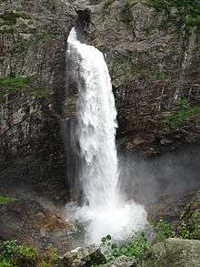
Gjesdal sits at the head of the Høgsfjorden and along the south and east sides of the Frafjorden. The Månafossen waterfall, the largest waterfall in Rogaland county, is located in the Frafjord valley. There are several large lakes in the municipality such as Edlandsvatnet, Flassavatnet, Limavatnet, and Oltedalsvatnet. The Figgjoelva river has its headwaters in Gjesdal also.
Weather
| Climate data for Gjesdal | |||||||||||||
|---|---|---|---|---|---|---|---|---|---|---|---|---|---|
| Month | Jan | Feb | Mar | Apr | May | Jun | Jul | Aug | Sep | Oct | Nov | Dec | Year |
| Daily mean °C (°F) | −0.1 (31.8) |
−0.2 (31.6) |
1.9 (35.4) |
4.8 (40.6) |
9.1 (48.4) |
12.1 (53.8) |
13.4 (56.1) |
13.6 (56.5) |
11.1 (52.0) |
8.1 (46.6) |
3.8 (38.8) |
1.4 (34.5) |
6.6 (43.9) |
| Average precipitation mm (inches) | 126 (5.0) |
90 (3.5) |
103 (4.1) |
65 (2.6) |
78 (3.1) |
85 (3.3) |
108 (4.3) |
140 (5.5) |
185 (7.3) |
195 (7.7) |
185 (7.3) |
155 (6.1) |
1,515 (59.6) |
| Average precipitation days (≥ 1 mm) | 15.5 | 12 | 14 | 11.2 | 12.5 | 12.2 | 13.1 | 15.3 | 18.1 | 18.5 | 19.1 | 17.7 | 179.2 |
| Source: Norwegian Meteorological Institute[10] | |||||||||||||
Notable residents
- Finn E. Kydland, winner of Bank of Sweden Prize in Economic Sciences in Memory of Alfred Nobel in 2004
- Dagny Mellgren, a Footballer from Ålgård
References
- "Navn på steder og personer: Innbyggjarnamn" (in Norwegian). Språkrådet.
- "Forskrift om målvedtak i kommunar og fylkeskommunar" (in Norwegian). Lovdata.no.
- Store norske leksikon. "Gjesdal" (in Norwegian). Retrieved 2016-03-14.
- Statistisk sentralbyrå (2017). "Table: 06913: Population 1 January and population changes during the calendar year (M)" (in Norwegian). Retrieved 2017-11-01.
- Rygh, Oluf (1915). Norske gaardnavne: Stavanger amt (in Norwegian) (10 ed.). Kristiania, Norge: W. C. Fabritius & sønners bogtrikkeri. pp. 155–159.
- Store norske leksikon. "Gjestal" (in Norwegian). Retrieved 2016-03-14.
- "Civic heraldry of Norway - Norske Kommunevåpen". Heraldry of the World. Retrieved 2016-03-14.
- Jukvam, Dag (1999). "Historisk oversikt over endringer i kommune- og fylkesinndelingen" (PDF) (in Norwegian). Statistisk sentralbyrå.
- "Table: 04813: Members of the local councils, by party/electoral list at the Municipal Council election (M)" (in Norwegian). Statistics Norway. 2015.
- "eKlima Web Portal". Norwegian Meteorological Institute. Archived from the original on 2004-06-14.
External links


- Municipal fact sheet from Statistics Norway (in Norwegian)
 |
|  | |||||||||||||||||||||||||
||