Kvitsøy
Kvitsøy is an island municipality in Rogaland county, Norway. At only 6.29-square-kilometre (2.43 sq mi), it is the smallest municipality in Norway by area and one of the smallest by population. Kvitsøy is located in the traditional district of Ryfylke. The administrative centre of the municipality is the village of Ydstebøhamn on the island of Kvitsøy. The municipality is an archipelago located at the entrance to the large Boknafjorden. It sits about 2 nautical miles (3.7 km; 2.3 mi) northwest of the mainland Stavanger peninsula. There are plans for the Rogfast tunnel to eventually connect Kvitsøy to the mainland road network.
Kvitsøy kommune | |
|---|---|
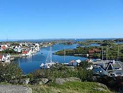 View of Ydstebøhamn | |
 Coat of arms  Rogaland within Norway | |
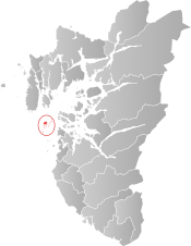 Kvitsøy within Rogaland | |
| Coordinates: 59°03′44″N 05°24′42″E | |
| Country | Norway |
| County | Rogaland |
| District | Ryfylke |
| Administrative centre | Ydstebøhamn |
| Government | |
| • Mayor (2011) | Mirjam Ydstebø (KrF) |
| Area | |
| • Total | 6.29 km2 (2.43 sq mi) |
| • Land | 6.28 km2 (2.42 sq mi) |
| • Water | 0.01 km2 (0.004 sq mi) |
| Area rank | 422 in Norway |
| Population (2017) | |
| • Total | 534 |
| • Rank | 417 in Norway |
| • Density | 85/km2 (220/sq mi) |
| • Change (10 years) | 1.3% |
| Demonym(s) | Kvitsøybu[1] |
| Time zone | UTC+01:00 (CET) |
| • Summer (DST) | UTC+02:00 (CEST) |
| ISO 3166 code | NO-1144 |
| Official language form | Neutral[2] |
| Website | www |
The 6-square-kilometre (2.3 sq mi) municipality is the 422nd largest by area out of the 422 municipalities in Norway, making it the smallest in the nation. Kvitsøy is the 417th most populous municipality in Norway with a population of 534. The municipality's population density is 85 inhabitants per square kilometre (220/sq mi) and its population has increased by 1.3% over the last decade.[3]
General information
The islands of Kvitsøy were established as a municipality on 1 January 1923 when they were separated from the municipality of Mosterøy on 1 January 1923. Initially, the municipality had 581 residents. The municipal boundaries have not changed since that time.[4]
Name
The Old Norse form of the name was Hvítingsøy(jar) which means "the white island(s)", probably because there is white quartz in the rocks on the islands. Originally, the spelling of the municipality was "Kvitingsø", but later it was shortened to "Kvitsøy".[4][5]
Coat-of-arms
The coat-of-arms is from modern times; they were granted in 1989. The arms show three silver lighthouses on a field of blue. The choice of lighthouses and the color blue are symbolic of the importance of the sea for this island municipality.[6]
Churches
The Church of Norway has one parish (sokn) within the municipality of Kvitsøy. It is part of the Tungenes deanery in the Diocese of Stavanger.
| Parish (Sokn) | Church Name | Location of the Church | Year Built |
|---|---|---|---|
| Kvitsøy | Kvitsøy Church | Kvitsøy | 1620 |
History
Kvitsøy is first mentioned in the Snorre Saga, where Snorre records a truce being made between King Olaf II of Norway later to be known as St. Olav (Norwegian: Hellige Olav) and Erling Skjalgsson, under the stone cross. Later it seems that the islands were owned by the Church until the reformation in 1536 (when the nation switched from Roman Catholicism to Lutheranism), when it became Crown property. In 1591, the population had become large enough to fund the construction of the Kvitsøy Church, which is still standing and the first new church in the county after the reformation. From the mid-18th century, Kvitsøy was the location of one of the first navigation beacons in western Norway, and this was later converted to a lighthouse service when the Kvitsøy Lighthouse was built. Kvitsøy Vessel Traffic Service Centre opened on 3 January 2003.[7]
Transmitter
Kvitsøy used to be the site of high power short wave and medium wave broadcasting transmitters of the national broadcasting company, NRK. The aerial tower of the medium-wave transmitter is the Kvitsøy Tower. The transmitter for the medium-wave channel 1314 kHz was switched off at 22:00 UTC (Midnight local time) on Friday June 30, 2006, shortwave broadcasts continued until 2011. In May and June 2012, the entire site was dismantled.[8]
Government
All municipalities in Norway, including Kvitsøy, are responsible for primary education (through 10th grade), outpatient health services, senior citizen services, unemployment and other social services, zoning, economic development, and municipal roads. The municipality is governed by a municipal council of elected representatives, which in turn elect a mayor.
Municipal council
The municipal council (Kommunestyre) of Kvitsøy is made up of 17 representatives that are elected to four year terms. Currently, the party breakdown is as follows:[9]
| Party Name (in Norwegian) | Number of representatives | |
|---|---|---|
| Progress Party (Fremskrittspartiet) | 2 | |
| Local List(s) (Lokale lister) | 13 | |
| Total number of members: | 15 | |
Geography
The municipality is an archipelago located at the entrance to the large Boknafjorden. It sits about 2 nautical miles (3.7 km; 2.3 mi) northwest of the mainland Stavanger peninsula and south of the islands of Karmøy and Vestre Bokn. The largest island is Kvitsøy, and it is connected with a few of the other islands in the archipelago, but most of the islands are uninhabited.
Nature
Climate
The islands are completely engulfed by the Gulf Stream and hence have a typically wet West Nordic coastal climate. The sea between the islands and the mainland is never frozen. Due to the maritime influence, summers are often chilly with temperatures between 15 °C (59 °F) and 20 °C (68 °F) being the norm. Winter highs usually are in the mid-single digits in all of the Greater Stavanger region.
Fauna and flora
There are no larger mammals in Kvitsøy except for seals (kobbe) and small dolphins (nise). The islands have a rich marine bird life. Many different plants are found on the islands. Some are natural to Norwegian flora, while others have been transported by ships emptying their hulls of ballast before entering the port of the nearby city of Stavanger.
References
- "Navn på steder og personer: Innbyggjarnamn" (in Norwegian). Språkrådet.
- "Forskrift om målvedtak i kommunar og fylkeskommunar" (in Norwegian). Lovdata.no.
- Statistisk sentralbyrå (2017). "Table: 06913: Population 1 January and population changes during the calendar year (M)" (in Norwegian). Retrieved 2017-11-01.
- Jukvam, Dag (1999). "Historisk oversikt over endringer i kommune- og fylkesinndelingen" (PDF) (in Norwegian). Statistisk sentralbyrå.
- Rygh, Oluf (1915). Norske gaardnavne: Stavanger amt (in Norwegian) (10 ed.). Kristiania, Norge: W. C. Fabritius & sønners bogtrikkeri. p. 270.
- "Civic heraldry of Norway - Norske Kommunevåpen". Heraldry of the World. Retrieved 2015-12-08.
- Førde, Thomas (2003-01-03). "Kvitsøy passer på til havs". Stavanger Aftenblad (in Norwegian). p. 19.
- Vaage, Lars Idar (2012-05-31). "Her sprenges den 125 meter høye masten". Aftenposten (in Norwegian). Retrieved 2015-12-08.
- "Table: 04813: Members of the local councils, by party/electoral list at the Municipal Council election (M)" (in Norwegian). Statistics Norway. 2015.
External links
| Wikimedia Commons has media related to Kvitsøy. |
| Look up Kvitsøy in Wiktionary, the free dictionary. |

- Municipal fact sheet from Statistics Norway (in Norwegian)
 |
|  | |||||||||||||||||||||||||
||