Lund, Norway
Lund is a municipality in Rogaland county, Norway. It is located in the traditional district of Dalane. The administrative centre of the municipality is the village of Moi. Other villages in Lund include Eik and, Heskestad. European route E39 and the Sørlandet Line both pass through Lund. Moi Station is a railway station in Lund.
Lund kommune | |
|---|---|
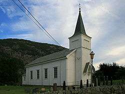 View of the local Heskestad Church | |
 Coat of arms  Rogaland within Norway | |
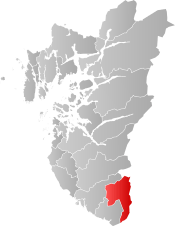 Lund within Rogaland | |
| Coordinates: 58°31′11″N 06°27′41″E | |
| Country | Norway |
| County | Rogaland |
| District | Dalane |
| Established | 1 Jan 1838 |
| Administrative centre | Moi |
| Government | |
| • Mayor (2019) | Hogne Skjerpe (H) |
| Area | |
| • Total | 408.42 km2 (157.69 sq mi) |
| • Land | 353.91 km2 (136.65 sq mi) |
| • Water | 54.51 km2 (21.05 sq mi) 13.3% |
| Area rank | 237 in Norway |
| Population (2020) | |
| • Total | 3,202 |
| • Rank | 222 in Norway |
| • Density | 9/km2 (20/sq mi) |
| • Change (10 years) | 2% |
| Demonym(s) | Lunddøl[1] |
| Time zone | UTC+01:00 (CET) |
| • Summer (DST) | UTC+02:00 (CEST) |
| ISO 3166 code | NO-1112 |
| Official language form | Neutral[2] |
| Website | lund |
The 408-square-kilometre (158 sq mi) municipality is the 237th largest by area out of the 356 municipalities in Norway. Lund is the 222nd most populous municipality in Norway with a population of 3,202. The municipality's population density is 9 inhabitants per square kilometre (23/sq mi) and its population has increased by 2% over the previous 10-year period.[3][4]
General information
The parish of Lunde (later spelled Lund) was established as a municipality on 1 January 1838 (see formannskapsdistrikt law). During the 1960s, there were many municipal mergers across Norway due to the work of the Schei Committee. On 1 January 1965, most of the municipality of Heskestad (population: 547) was merged with Lund to form a much larger municipality of Lund.[5]
Name
The municipality (originally the parish) is named after the old Lund farm (Old Norse: Lundr), since the first Lund Church was built there. The name is identical with the word lundr which means "grove" (but here maybe 'sacred grove'). Before 1889, the name was written "Lunde".[6]
Coat of arms
The coat of arms was granted on 14 December 1984. The arms show three joined acorns in gold on a green background. The acorns symbolize the many oak trees in the municipality, as well as many toponyms and names of farms, which start with Eik (oak), such as Eik, Eike, and Eikeland.[7]
Churches
The Church of Norway has two parishes (sokn) within the municipality of Lund. It is part of the Dalane prosti (deanery) in the Diocese of Stavanger.
| Parish (sokn) | Church name | Location of the church | Year built |
|---|---|---|---|
| Heskestad | Heskestad Church | Heskestad | 1904 |
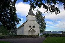
| Lund | Lund Church | Moi | 1808 |
Government
All municipalities in Norway, including Lund, are responsible for primary education (through 10th grade), outpatient health services, senior citizen services, unemployment and other social services, zoning, economic development, and municipal roads. The municipality is governed by a municipal council of elected representatives, which in turn elect a mayor.[8] The municipality falls under the Dalane District Court and the Gulating Court of Appeal.
Municipal council
The municipal council (Kommunestyre) of Lund is made up of 21 representatives that are elected to four year terms. Currently, the party breakdown is as follows:
| Party Name (in Norwegian) | Number of representatives | |
|---|---|---|
| Labour Party (Arbeiderpartiet) | 7 | |
| Progress Party (Fremskrittspartiet) | 4 | |
| Conservative Party (Høyre) | 3 | |
| Christian Democratic Party (Kristelig Folkeparti) | 3 | |
| Centre Party (Senterpartiet) | 2 | |
| Liberal Party (Venstre) | 2 | |
| Total number of members: | 21 | |
Geography
The municipality of Lund lies in southeastern Rogaland county, along the border with Agder county. The municipality of Sokndal lies to the south, Eigersund lies to the west, Sirdal (in Agder) to the north/northeast, and Flekkefjord (also in Agder) to the east. The lake Lundevatnet lies on the southeastern border of Lund. The lake Hovsvatnet lies in the central part of Lund, north of Moi. The lakes Grøsfjellvatnet and Teksevatnet lie on the western borders of Lund.
Climate
| Climate data for Moi | |||||||||||||
|---|---|---|---|---|---|---|---|---|---|---|---|---|---|
| Month | Jan | Feb | Mar | Apr | May | Jun | Jul | Aug | Sep | Oct | Nov | Dec | Year |
| Daily mean °C (°F) | −1.5 (29.3) |
−1.5 (29.3) |
1.0 (33.8) |
4.4 (39.9) |
9.3 (48.7) |
13.0 (55.4) |
14.2 (57.6) |
13.7 (56.7) |
10.6 (51.1) |
7.6 (45.7) |
3.0 (37.4) |
−0.6 (30.9) |
6.1 (43.0) |
| Average precipitation mm (inches) | 198 (7.8) |
145 (5.7) |
156 (6.1) |
90 (3.5) |
113 (4.4) |
111 (4.4) |
122 (4.8) |
170 (6.7) |
232 (9.1) |
273 (10.7) |
258 (10.2) |
222 (8.7) |
2,090 (82.3) |
| Source: Norwegian Meteorological Institute[10] | |||||||||||||
Notable residents
- Magnhild Eia, the former deputy mayor of Lund
References
- "Navn på steder og personer: Innbyggjarnamn" (in Norwegian). Språkrådet.
- "Forskrift om målvedtak i kommunar og fylkeskommunar" (in Norwegian). Lovdata.no.
- Statistisk sentralbyrå (2020). "Table: 06913: Population 1 January and population changes during the calendar year (M)" (in Norwegian).
- Statistisk sentralbyrå (2020). "09280: Area of land and fresh water (km²) (M)" (in Norwegian).
- Jukvam, Dag (1999). "Historisk oversikt over endringer i kommune- og fylkesinndelingen" (PDF) (in Norwegian). Statistisk sentralbyrå.
- Rygh, Oluf (1915). Norske gaardnavne: Stavanger amt (in Norwegian) (10 ed.). Kristiania, Norge: W. C. Fabritius & sønners bogtrikkeri. p. 28.
- "Civic heraldry of Norway - Norske Kommunevåpen". Heraldry of the World. Retrieved 23 July 2016.
- Hansen, Tore, ed. (12 May 2016). "kommunestyre". Store norske leksikon (in Norwegian). Kunnskapsforlaget. Retrieved 28 June 2020.
- "Table: 04813: Members of the local councils, by party/electoral list at the Municipal Council election (M)" (in Norwegian). Statistics Norway.
- "eKlima Web Portal". Norwegian Meteorological Institute. Archived from the original on 14 June 2004.
External links
| Wikimedia Commons has media related to Lund. |
| Look up Lund in Wiktionary, the free dictionary. |
| Wikivoyage has a travel guide for Rogaland. |
- Municipal fact sheet from Statistics Norway (in Norwegian)
 |
|  | |||||||||||||||||||||||||
||
| Authority control |
|
|---|