Sisak
Sisak (Croatian: [sǐːsak]; Hungarian: Sziszek [ˈsisɛk]; also known by other alternative names) is a city and episcopal see in central Croatia, located at the confluence of the Kupa, Sava and Odra rivers, 57 km (35 mi) southeast of the Croatian capital Zagreb, and is usually considered to be where the Posavina (Sava basin) begins, with an elevation of 99 m. The city's total population in 2011 was 47,768 of which 33,322 live in the urban settlement (naselje).[3]
Sisak | |
|---|---|
| Grad Sisak City of Sisak | |
 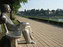  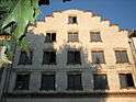 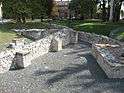 Top: Old bridge over the Kupa river; Center left: Antun Gustav Matoš monument; Center right: Sisak Fortress; Bottom left: Holland Storehouse; Bottom right: Roman ruins of Siscia | |
 Flag | |
 Sisak Location of Sisak within Croatia | |
| Coordinates: 45°28′13.74″N 16°23′10.04″E | |
| Country | |
| County | |
| Government | |
| • Mayor | Kristina Ikić Baniček[1] (SDP) |
| • City Council | 25 members
|
| Area | |
| • City | 422.75 km2 (163.22 sq mi) |
| • Metro | 989.50 km2 (382.05 sq mi) |
| Elevation | 98 m (321.52 ft) |
| Population (2011)[2] | |
| • City | 47,768 |
| Time zone | UTC+1 (CET) |
| • Summer (DST) | UTC+2 (CEST) |
| Postal code | HR-44 000, HR-44 010 |
| Area code | +385 44 |
| Vehicle registration | SK |
| Patron saints | Quirinus of Sescia |
| Website | www |
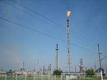
Sisak is the administrative centre of the Sisak-Moslavina County, Croatia's biggest river port and a centre of river shipping industry (Dunavski Lloyd). It lies on the D36 state road and the Zagreb-Sisak-Novska railway. Sisak is a regional economic, cultural and historical center. The largest oil refinery in Croatia is located here.[4]
Name
Prior to belonging to the Roman Empire, which gave it the Latin name Siscia, the region was Celtic and Illyrian and the city there was named Segestica[5] or Segesta.[6] Writers in Greek referred to the city as Ancient Greek: Σισκία, romanized: Siskía, Σεγέστα Segésta, and Σεγεστική Segestikḗ.[6]
In German the town is known as Sissek, in Hungarian as Sziszek, Latin as Siscia and in Kajkavian and Slovene as Sisek.
History
Roman empire
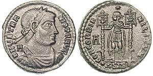
Siscia is described by Roman writers as a great town in the south of Upper Pannonia, on the southern bank of the Savus, on an island formed by that river and two others, the Colapis and Odra, a canal dug by Tiberius completing the island.[6] It was situated on the great road from Aemona to Sirmium.[7] According to Pliny the name Segestica belonged only to the island, and the town was called Siscia; while Strabo says that Siscia was a fort in the neighbourhood of Segestica;[8] but if this was so, it must be supposed that subsequently the fort and town became united as one place. Siscia was from the first a strongly fortified town; and after its capture by Tiberius, in the reign of Augustus,[9] it became one of the most important places of Pannonia; for being situated on two navigable rivers, it not only carried on considerable commerce,[10] but became the central point from which Augustus and Tiberius carried on their undertakings against the Pannonians and Illyrians. Tiberius did much to enlarge and embellish the town, which as early as that time seems to have been made a colonia, for Pliny mentions it as such: in the time of Septimius Severus it received fresh colonists, whence in inscriptions it is called Col. Septimia Siscia. The town contained an imperial mint, which produced coins under a series of emperors between 262 and 383 AD.[11]
The Christian martyr Quirinus of Sescia, presumed the first bishop of the Diocese of Sescia, was tortured and nearly killed during Diocletian's persecution of Christians. Legend has it that they tied him to a millstone and threw him into a river, but he freed himself from the weight, escaped and continued to preach his faith. Today he is the patron saint of Sisak. When Diocletian split Pannonia into four provinces, Siscia became the capital of Pannonia Savia, the southwestern one, for which Siscia contained the treasury; at the same time it was the station of the small fleet kept on the Savus. Siscia maintained its importance until Sirmium began to rise, for in proportion as Sirmium rose, Siscia sank and declined.[6]
Middle Ages
Braslav of Lower Pannonia reigned from Sisak until he was killed in the Hungarian invasion ca. 898.[12] According to Historia Salonitana, Duke Tomislav reclaimed it soon after.[13][14]
Early modern
The 16th-century triangular fortress of the Old Town, well-preserved and turned into the Native Museum, is the main destination of every tourist. The fortress is famous for the victory of the joint forces of Croats, Austrians and Carniolans (Slovenes) over the Ottomans in 1593, known as the Battle of Sisak. It was one of the early significant defeats of the up-to-then invincible Ottoman army on European territory. The Croatian Ban Thomas Erdődy who led the defense in this battle became famous throughout Europe. The Baroque palace of Mali Kaptol, the classicist Veliki Kaptol, the brick Stari most ("Old Bridge") over the Kupa, and the ethnological park are the most frequently visited landmarks. However, this victory didn't prevent Sisak from brief Ottoman rule between 30 August 1593 and 10 August 1594.
Modern
In the late 19th and early 20th century, Sisak was a district capital in the Zagreb County of the Kingdom of Croatia-Slavonia.
Contemporary
From 1929–39, Sisak was part of the Sava Banovina and from 1939-41 of the Banovina of Croatia within the Kingdom of Yugoslavia. During World War II, Sisak children's concentration camp was set up by the Croatian Axis Ustaše government for Serbian, Jewish and Romani children. It is estimated that 1,152–2,000 children were killed in the camp.[15]
With the outbreak of the Croatian War in 1991, Sisak remained in Government hands while the territory to the south was controlled by rebelled Serbs. During the war, the Serb forces often shelled the city, causing dozens of civilian casualties and extensive damage to the city's industry.[16] The war ended with the Operation Storm (1995).
Population
| Historical population of Sisak | ||
|---|---|---|
| Year | Pop. | ±% |
| 1857 | 15,738 | — |
| 1869 | 18,669 | +18.6% |
| 1880 | 24,433 | +30.9% |
| 1890 | 38,181 | +56.3% |
| 1900 | 51,821 | +35.7% |
| 1910 | 73,831 | +42.5% |
| 1921 | 102,912 | +39.4% |
| 1931 | 138,414 | +34.5% |
| 1948 | 11,293 | −91.8% |
| 1953 | 12,921 | +14.4% |
| 1961 | 26,821 | +107.6% |
| 1971 | 39,633 | +47.8% |
| 1981 | 65,822 | +66.1% |
| 1991 | 78,531 | +19.3% |
| 2001 | 85,212 | +8.5% |
| 2011 | 88,768 | +4.2% |
| Source: Naselja i stanovništvo Republike Hrvatske 1857–2001, DZS, Zagreb, 2005 & Popis stanovništva 2011 | ||
In the 2011 census, of the total population of 47,768 there were 40,590 Croats (84.97%), 3,071 Serbs (6.43%), 1,646 Bosniaks (3.45%), 648 Romani (1.36%), 179 Albanians (0.37%), 29 Montenegrins (0.06%), and the rest were other ethnicities.
In the 2011 census, the population by religion was 37,319 Roman Catholics (78.13%; since 2009 again served by their own Diocese of Sisak), 3,279 Orthodox Christians (6.86%), 2,442 Muslims (5.11%) and others.
Municipal makeup
The city's administrative area is composed of the following settlements:[2]
- Blinjski Kut, population 278
- Budaševo, population 1,660
- Bukovsko, population 89
- Crnac, population 553
- Čigoč, population 97
- Donje Komarevo, population 322
- Gornje Komarevo, population 508
- Greda, population 861
- Gušće, population 387
- Hrastelnica, population 898
- Jazvenik, population 142
- Klobučak, population 68
- Kratečko, population 200
- Letovanci, population 52
- Lonja, population 111
- Lukavec Posavski, population 127
- Madžari, population 235
- Mužilovčica, population 74
- Novo Pračno, population 444
- Novo Selo, population 624
- Novo Selo Palanječko, population 517
- Odra Sisačka, population 814
- Palanjek, population 318
- Prelošćica, population 528
- Sela, population 969
- Sisak, population 33,049
- Stara Drenčina, population 223
- Staro Pračno, population 896
- Staro Selo, population 110
- Stupno, population 480
- Suvoj, population 42
- Topolovac, population 894
- Veliko Svinjičko, population 271
- Vurot, population 102
- Žabno, population 509
Miscellaneous

Chief occupations are farming, ferrous metallurgy (iron works), chemicals, leather (footwear), textiles and food processing plants (dairy products, alcoholic beverages), building material, crude oil refinery and thermal power.
Sisak features the largest metallurgic factory and the largest oil refinery in Croatia. Sisak has many rich mineral springs (spas) with healing properties in the temperature range from 42 to 54 °C (108 to 129 °F).
The city hosts University of Zagreb's Faculty of Metallurgy.
Sports and recreation facilities in the town and the surroundings include mainly the waters and alluvial plains a public beach on the Kupa. All rivers (Kupa, Odra, Sava) with their backwaters offer fishing opportunities. There are hunting grounds in the regions of Turopolje and Posavina. Sisak is the starting point for sightseeing tours into Lonjsko Polje (Field of Lonja river) nature park. The local football club is HNK Segesta. Sisak features the oldest ice hockey club in Croatia, KHL Sisak est. 1934.
Geography
Climate
| Climate data for Sisak (1971–2000, extremes 1949–2014) | |||||||||||||
|---|---|---|---|---|---|---|---|---|---|---|---|---|---|
| Month | Jan | Feb | Mar | Apr | May | Jun | Jul | Aug | Sep | Oct | Nov | Dec | Year |
| Record high °C (°F) | 21.4 (70.5) |
23.4 (74.1) |
27.4 (81.3) |
31.1 (88.0) |
34.3 (93.7) |
38.1 (100.6) |
39.8 (103.6) |
40.0 (104.0) |
34.9 (94.8) |
29.6 (85.3) |
25.0 (77.0) |
23.7 (74.7) |
40.0 (104.0) |
| Average high °C (°F) | 3.7 (38.7) |
6.8 (44.2) |
12.2 (54.0) |
16.7 (62.1) |
21.9 (71.4) |
24.8 (76.6) |
27.0 (80.6) |
26.6 (79.9) |
22.4 (72.3) |
16.2 (61.2) |
9.1 (48.4) |
4.7 (40.5) |
16.0 (60.8) |
| Daily mean °C (°F) | 0.5 (32.9) |
2.4 (36.3) |
6.8 (44.2) |
11.2 (52.2) |
16.2 (61.2) |
19.4 (66.9) |
21.2 (70.2) |
20.4 (68.7) |
16.1 (61.0) |
10.8 (51.4) |
5.3 (41.5) |
1.5 (34.7) |
11.0 (51.8) |
| Average low °C (°F) | −3.1 (26.4) |
−2.0 (28.4) |
1.5 (34.7) |
5.4 (41.7) |
9.9 (49.8) |
13.1 (55.6) |
14.7 (58.5) |
14.3 (57.7) |
10.5 (50.9) |
6.1 (43.0) |
1.6 (34.9) |
−1.7 (28.9) |
5.9 (42.6) |
| Record low °C (°F) | −25.2 (−13.4) |
−25 (−13) |
−18.4 (−1.1) |
−5 (23) |
−2.3 (27.9) |
1.9 (35.4) |
5.4 (41.7) |
3.9 (39.0) |
−1.8 (28.8) |
−7.2 (19.0) |
−15.6 (3.9) |
−19.2 (−2.6) |
−25.2 (−13.4) |
| Average precipitation mm (inches) | 49.0 (1.93) |
48.2 (1.90) |
55.0 (2.17) |
69.4 (2.73) |
79.4 (3.13) |
94.7 (3.73) |
80.2 (3.16) |
77.8 (3.06) |
84.5 (3.33) |
78.7 (3.10) |
91.1 (3.59) |
68.3 (2.69) |
876.1 (34.49) |
| Average precipitation days (≥ 0.1 mm) | 11.7 | 10.9 | 11.6 | 13.8 | 13.0 | 13.8 | 10.9 | 10.1 | 11.5 | 12.3 | 12.0 | 12.4 | 143.9 |
| Average snowy days (≥ 1.0 cm) | 11.8 | 8.4 | 2.5 | 0.4 | 0.0 | 0.0 | 0.0 | 0.0 | 0.0 | 0.0 | 3.5 | 8.3 | 34.8 |
| Average relative humidity (%) | 85.0 | 78.7 | 71.3 | 68.5 | 69.8 | 71.1 | 71.1 | 74.9 | 79.9 | 82.8 | 85.8 | 87.3 | 77.2 |
| Mean monthly sunshine hours | 52.7 | 93.2 | 142.6 | 174.0 | 235.6 | 246.0 | 285.2 | 257.3 | 186.0 | 114.7 | 54.0 | 43.4 | 1,884.7 |
| Source: Croatian Meteorological and Hydrological Service[17][18] | |||||||||||||
International relations
Twin towns – Sister cities
Sisak is twinned with:
|
|
References
Bibliography
- Cresswell, Peterjon; Atkins, Ismay; Dunn, Lily (10 July 2006). Time Out Croatia (First ed.). London, Berkeley & Toronto: Time Out Group Ltd & Ebury Publishing, Random House Ltd. 20 Vauxhall Bridge Road, London SV1V 2SA. ISBN 978-1-904978-70-1. Retrieved 10 March 2010.
Notes
- "2013 Lokalni". Izbori.hr. Retrieved 8 December 2015.
- "Population by Age and Sex, by Settlements, 2011 Census: Sisak". Census of Population, Households and Dwellings 2011. Zagreb: Croatian Bureau of Statistics. December 2012.
- "Državni zavod za statistiku Republike Hrvatske". Dzs.hr. Retrieved 8 December 2015.
- Archived 1 May 2007 at the Wayback Machine
- John T. Koch (2006). Celtic Culture. p. 1662. ISBN 1-85109-440-7.
-

- It. Ant. pp. 259, 260, 265, 266, 272, 274; Pliny. Naturalis Historia. 3.28.
- Strabo. Geographica. vii. p.314. Page numbers refer to those of Isaac Casaubon's edition.
- Appian, The Illyrian Wars, 16, 23.
- Strabo. Geographica. v. pp. 207, 214. Page numbers refer to those of Isaac Casaubon's edition.
- "Details for issuing mint located at Siscia (Sisak, Croatia)". Finds.org.uk. 22 February 1999. Retrieved 8 December 2015.
- John Van Antwerp Fine; John V. A. Fine, Jr. (2006). When Ethnicity Did Not Matter in the Balkans. University of Michigan Press. p. 28. ISBN 0-472-11414-X.
- John Van Antwerp Fine; John V. A. Fine, Jr. (2006). When Ethnicity Did Not Matter in the Balkans. University of Michigan Press. p. 178. ISBN 0-472-11414-X.
- Stanko Guldescu (1964). History of Medieval Croatia. Mouton. p. 113.
- "Sisak: Srbi traže da logor za djecu uđe u udžbenike". Glassrpske.com. Retrieved 8 December 2015.
- "11 kaznenih prijava za razaranje Siska". Jutarnji list (in Croatian). 27 January 2007. Archived from the original on 28 September 2015. Retrieved 27 September 2015.
- "Sisak Climate Normals" (PDF). Croatian Meteorological and Hydrological Service. Retrieved 3 December 2015.
- "Mjesečne vrijednosti za Sisak u razdoblju1949−2014" (in Croatian). Croatian Meteorological and Hydrological Service. Retrieved 3 December 2015.
- "Twin Towns". Gabrovo.bg. Archived from the original on 2 August 2014. Retrieved 27 April 2014.
External links
| Wikimedia Commons has media related to Sisak. |
| Wikisource has the text of the 1913 Catholic Encyclopedia article Croatia. |
- Official website
- Sisak News Portal
- Radio Sisak - Hometown radio station
- Sisak Tourism
- Photo Gallery of Sisak
- Chisholm, Hugh, ed. (1911). . Encyclopædia Britannica (11th ed.). Cambridge University Press.
Cities and towns of Croatia by population | ||
|---|---|---|
| 100,000+ |  Coat of arms of Croatia | |
| 35,000+ | ||
| 10,000+ |
| |
Subdivisions of Sisak-Moslavina County | ||
|---|---|---|
| Cities and towns | Coat of arms of Sisak-Moslavina County | |
| Municipalities | ||
| Authority control |
|
|---|