Zadar County
Zadar County (Croatian: Zadarska županija [zâdarskaː ʒupǎnija]) is a county in Croatia, it encompasses northern Dalmatia and southeastern Lika. Its center is the city of Zadar.
Zadar County Zadarska županija | |
|---|---|
 Flag  Coat of arms | |
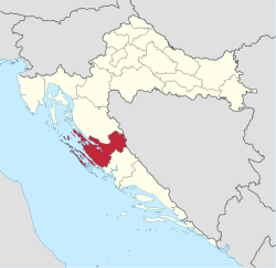 Zadar County within Croatia | |
| Country | |
| County seat | |
| Government | |
| • Župan | Božidar Longin (HDZ) |
| • County Assembly | 42 members[1]
|
| Area | |
| • Total | 3,646 km2 (1,408 sq mi) |
| Population (2011)[3] | |
| • Total | 170,017 |
| • Density | 47/km2 (120/sq mi) |
| Area code | 023 |
| ISO 3166 code | HR-13 |
| HDI (2017) | 0.813[4] very high · 7th |
| Website | www |
Population
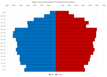
According to the 2011 census, Zadar County has population of 170,017, accounting for 4.0% of the total Croatia's population.[3] Croats make up the majority with 92.57% of the population, while Serbs, Bosniaks, Albanians and Italians form the remainder.[5]
Geography
Among the largest towns in the county of Zadar are: Zadar, Benkovac, Bibinje, Biograd, Nin, Obrovac and Pag.
The county of Zadar includes the islands of Dugi otok, Ugljan, Pašman, Molat, Lavdara, Zverinac, Vir and most of Pag, as well as a number of other, smaller islands. It also features the Paklenica national park.
The county's area is 7,854 km2, 3,646 km2 is land, which accounts for 6.4% of the territory of Croatia. The sea area of the County is 3,632 km2 (around 12% of the territorial waters) and the insular area is 580 km2, with more than 300 smaller and larger islands (Zadar Archipelago). The length of its coastline (including the islands) is 1,300 km.[6][7]
Infrastructure
The County of Zadar plays a leading role in road and railway traffic links between northern and southern Croatia.
The main road along the Adriatic Sea passes through the county, as does the new Zagreb-Dubrovnik highway, completed as far as Split in 2005. The Zagreb-Knin-Split railway line with branch-lines to Zadar and Šibenik pass through the County.
Maritime traffic is carried by the coastal route of the Adriatic Sea, by the Zadar-Ancona international car ferry route which is the shortest link between Central Europe and Italy, via Zagreb and Zadar to Rome and southward. Another route by which intensive traffic is carried is Zadar - Maslenica Bridge - St. Rok Tunnel - Zagreb.
The Zadar Airport has recently been reconstructed and modernised. With runway improvements still to be undertaken it will eventually have the capacity to handle jumbo-jets.
There is also a very frequent maritime passenger port in the town of Zadar and the cargo maritime port in the Gazenica area whose current manipulative capacity amounts to one million tonnes per year. A construction of a wharf would raise this significantly. The port's manipulative and warehouse capacities are used only in part.
Economy
The Ravni Kotari area constitutes the greater part of the County's inland, containing most of the cultivated farmland and towns having industry, crafts, trade and traffic development potential.
Tourism is one of the County's most important industries, owing to its geographical position, mild climate, indented coast, clear sea, numerous bays, inlets and beaches on 1,300 km of the sea coast and islands. Tourist amenities of the Zadar County are also the areas of outstanding natural beauty: the Velebit, Telaščica and Paklenica and adjacent Krka and Kornati national parks in the south and the Plitvice Lakes national park in the north.
Administrative division
Zadar County is divided into:
- City
- Towns
- Benkovac
- Biograd na Moru
- Nin
- Obrovac
- Pag
- Municipalities
County government
See organization of Croatian counties.
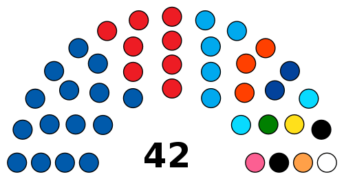
As of 2014, the Župan is Božidar Longin of the Croatian Democratic Union (HDZ),[8] and the county assembly's 42 representatives are affiliated as follows:[9]
- Croatian Democratic Union: 15
- Social Democratic Party of Croatia (SDP): 8
- Croatian Party of Rights dr. Ante Starčević: 5
- Akcija mladih: 3
- Lista grupe birača: 2
- Croatian Party of Pensioners (HSU): 2
- Croatian Peasants Party (HSS): 1
- Croatian Social Liberal Party (HSLS): 1
- Croatian Party of Rights (HSP): 1
- Democratic Party of Pensioners (DSU): 1
- Croatian Pure Party of Rights (HČSP): 1
- Croatian Labourists – Labour Party: 1
- Independent: 1
 Krupa River in Velebit nature park
References
- https://www.zadarska-zupanija.hr/images/dokumenti/VIJECNICI_ZUPANIJSKE_SKUPSTINE-2017.pdf.pdf
- Ostroški, Ljiljana, ed. (December 2015). Statistički ljetopis Republike Hrvatske 2015 [Statistical Yearbook of the Republic of Croatia 2015] (PDF). Statistical Yearbook of the Republic of Croatia (in Croatian and English). 47. Zagreb: Croatian Bureau of Statistics. p. 62. ISSN 1333-3305. Retrieved 27 December 2015.
- "Population by Age and Sex, by Settlements, 2011 Census". Census of Population, Households and Dwellings 2011. Zagreb: Croatian Bureau of Statistics. December 2012.
- "Sub-national HDI - Area Database - Global Data Lab". hdi.globaldatalab.org. Retrieved 2018-09-13.
- "Population by Ethnicity, by Towns/Municipalities, 2011 Census". Census of Population, Households and Dwellings 2011. Zagreb: Croatian Bureau of Statistics. December 2012.
- "International Student Guide" (PDF). University of Zadar. Archived from the original (PDF) on 16 July 2011.
- "Tourism" (PDF). Zadar County. p. 20. Retrieved 27 March 2014.
- "Župan Stipe Zrilić". zadarska-zupanija.hr (in Croatian). Retrieved 27 March 2014.
- "Vijećnici Županijske skupštine Zadarske županije" (PDF). zadarska-zupanija.hr (in Croatian). Retrieved 27 March 2014.
External links
Subdivisions of Zadar County | ||
|---|---|---|
| Cities and towns | Coat of arms of Zadar County | |
| Municipalities | ||