Geographica
The Geographica (Ancient Greek: Γεωγραφικά Geōgraphiká), or Geography, is an encyclopedia of geographical knowledge, consisting of 17 'books', written in Greek by Strabo, an educated citizen of the Roman Empire of Greek descent. Work can have begun on it no earlier than 20 BC. A first edition was published in 7 BC followed by a gap, resumption of work and a final edition no later than 23 AD in the last year of Strabo's life. Strabo probably worked on his Geography and now missing History concurrently, as the Geography contains a considerable amount of historical data. Except for parts of Book 7, the complete work is known.
Title of the work
Strabo refers to his Geography within it by several names:[1]
- geōgraphia, "description of the earth"[2]
- chōrographia, "description of the land"
- periēgēsis, "an outline"[3]
- periodos gēs, "circuit of the earth"[4]
- periodeia tēs chōrās, "circuit of the land"[5]
Apart from the "outline", two words recur, "earth" and "country." Something of a theorist, Strabo explains what he means by Geography and Chorography:[6]
It is the sea more than anything else that defines the contours of the land (geōgraphei) and gives it its shape, by forming gulfs, deep seas, straits and likewise isthmuses, peninsulas, and promontories; but both the rivers and the mountains assist the seas herein. It is through such natural features that we gain a clear conception of continents, nations, favourable positions of cities and all the other diversified details with which our geographical map (chorographikos pinax) is filled.
From this description it is clear that by geography Strabo means ancient physical geography and by chorography, political geography. The two are combined in this work, which makes a "circuit of the earth" detailing the physical and political features. Strabo often uses the adjective geōgraphika with reference to the works of others and to geography in general, but not of his own work. In the Middle Ages it became the standard name used of his work.
Date
The date of Geographica is a large topic, perhaps because Strabo worked on it along with his History for most of his adult life. He traveled extensively, undoubtedly gathering notes, and made extended visits to Rome and Alexandria, where he is sure to have spent time in the famous library taking notes from his sources.
Strabo visited Rome in 44 BC at age 19 or 20 apparently for purposes of education. He studied under various persons, including Tyrannion, a captive educated Greek and private tutor, who instructed Cicero's two sons. Cicero says:[7]
The geographical work I had planned is a big undertaking...if I take Tyrannion's views too...
If one presumes that Strabo acquired the motivation for writing geography during his education, the latter must have been complete by the time of his next visit to Rome in 35 BC at 29 years old. He may have been gathering notes but the earliest indication that he must have been preparing them is his extended visit to Alexandria 25–20 BC. In 20 he was 44 years old. His "numerous excerpts" from "the works of his predecessors" are most likely to have been noted at the library there.[8] Whether these hypothetical notes first found their way into his history and then into his geography or were simply ported along as notes remains unknown.
Most of the events of the life of Augustus mentioned by Strabo occurred 31–7 BC with a gap 6 BC – 14 AD, which can be interpreted as an interval after first publication in 7 BC.[9] Then in 19 AD a specific reference dates a passage: he said that the Carni and Norici had been at peace since they were "stopped ... from their riotous incursions ...." by Drusus 33 years ago, which was 15 BC, dating the passage 19 AD.[10] The latest event mentioned is the death of Juba at no later than 23 AD, when Strabo was in his 80s. These events can be interpreted as a second edition unless he saved all his notes and wrote the book entirely after the age of 80.
Composition
Strabo is his own best expounder of his principles of composition:[11]
In short, this book of mine should be ... useful alike to the statesman and to the public at large – as was my work on History. ... And so, after I had written my Historical Sketches ... I determined to write the present treatise also; for this work is based on the same plan, and is addressed to the same class of readers, and particularly to men of exalted stations in life. ... in this work also I must leave untouched what is petty and inconspicuous, and devote my attention to what is noble and great, and to what contains the practically useful, or memorable, or entertaining. ... For it, too, is a colossal work, in that it deals with the facts about large things only, and wholes ....
Subject matter
An outline of the encyclopedia follows, with links to the appropriate Wikipedia article.
Book I – definition and history of geography
Pages C1 through C67, Loeb Volume I pages 3–249.
Chapter 1 – description of geography and this encyclopedia
| Book | Section | Description |
|---|---|---|
| I.1 | 1 | Geography is a branch of philosophy. |
| 2 | Homer is the founder of geography. | |
| 3 | The Ocean. | |
| 4 | The Elysian Plain. | |
| 5 | The Isles of the Blessed. | |
| 6 | The Aethiopians, Definition of the Arctic Circle | |
| 7–9 | Tides of the Ocean. Earth is an island. | |
| 10 | The Mediterranean, the land of the Cimmerians, the Ister. | |
| 11 | Anaximander and Hecataeus. | |
| 12 | Hipparchus and the climata. | |
| 13 | The antipodes. | |
| 14–19 | The ecumene. Geography requires encyclopedic knowledge of celestial, terrestrial and maritime features as well as natural history and mathematics and is of strategic interest. | |
| 20 | Earth is a sphere with surface curved by the law of gravity, that bodies move to the center. | |
| 21 | Knowledge of geometry is required to understand geography. | |
| 22–23 | The purpose and plan of the encyclopedia. |
Chapter 2 – contributors to geography
| Book | Section | Description |
|---|---|---|
| I.2 | 1 | Contributions of the Romans and Parthians to geography |
| 2–3 | Critique of Eratosthenes | |
| 4–40 | Critique of Homer's and the other poets' geography and various writers' view of it, especially Eratosthenes'. |
Chapter 3 – physical geography
| Book | Section | Description |
|---|---|---|
| I.3 | 1–2 | Critiques of Eratosthenes' sources: Damastes, Euhemerus. |
| 3 | Critiques of Eratosthenes' geology, shape of the Earth. | |
| 4–7 | Fossils, formation of the seas. | |
| 8–9 | Silting. | |
| 10 | Volcanic action. | |
| 11–12 | Currents. | |
| 13–15 | More on the formation of the seas. | |
| 16–20 | Island-building, earthquakes | |
| 21 | Human migration. | |
| 22–23 | Hyperboreans, Hypernotians |
Chapter 4 – political geography
| Book | Section | Description |
|---|---|---|
| I.4 | 1 | Heaven is spherical corresponding to Earth's sphericity. |
| 2–6 | Distances along lines of latitude and longitude to various peoples and places. | |
| 7–8 | The three continents: Europe, Asia, Libya. | |
| 9 | Recommends Alexander the Great's division of people into good or bad rather than the traditional Greek barbarians and Greeks. |
Book II – mathematics of geography
Pages C67 through C136, Loeb Volume I pages 252–521.
Chapter 1 – distances between parallels and meridians
| Book | Section | Description |
|---|---|---|
| II.1 | 1–3 | Relates Eratosthenes' description of the Tropic of Cancer, which was based on Patrocles. |
| 4–5 | Critiques Hipparchus' criticism of Patrocles, which was based on Deimachus and Megasthenes. Points out that Eratosthenes used the Library of Alexandria. | |
| 6–8 | Critique of Patrocles. | |
| 9 | Fabrications of the geographers concerning India. | |
| 10–41 | Calculations of distances between parallels and meridians passing through various places in the habitable world, according to various geographers: Hipparchus, Eratosthenes, Pytheas, Deimachus. |
Chapter 2 – the five zones
| Book | Section | Description |
|---|---|---|
| II.2 | 1 | Introduces the work Oceans by Poseidonius. |
| 2–3 | Critiques Poseidonius, who criticises Parmenides and Aristotle on the widths and locations of the five zones. |
Chapter 3 – distribution of plants, animals, civilizations
| Book | Section | Description |
|---|---|---|
| II.3 | 1–3 | Critiques the six zones of Polybius. |
| 4 | Describes African voyages: the circumnavigation by an expedition sent by Necho II, another by Magus; to India by Eudoxus of Cyzicus. | |
| 5 | Adventures and misadventures of Eudoxus. Attacks the credibility of Pytheas, Euhemerus, Antiphanes. | |
| 6 | Poseidonius' theory of Atlantis; attributes migration of Cimbri to inundation. | |
| 7 | Attributes the distribution of plants, animals and civilizations to chance (suntuchia) rather than to zones (which was Poseidonius' theory). | |
| 8 | Example of random racial distribution: Ethiopians were in both Asia (India) and Libya (Africa). Strabo says his school avoids such causal connections. |
Chapter 4 – criticisms of Polybius' and Eratosthenes' maps
| Book | Section | Description |
|---|---|---|
| II.4 | 1–2 | Polybius' critique of Pytheas. |
| 3 | Strabo's criticisms of Polybius' European distances. | |
| 4 | Strabo's criticisms of Polybius' critique of the distances of Eratosthenes. | |
| 5–6 | Strabo's corrections to various geographers' descriptions of the locations of the Tanaïs, the Tyras, the Borysthenes and the Hypanis. | |
| 7 | Strabo criticises Polybius' length of the inhabited world. | |
| 8 | Strabo criticises Polybius' and Eratosthenes' physical divisions of Europe. |
Chapter 5 – Strabo's view of the ecumene
| Book | Section | Description |
|---|---|---|
| II.5 | 1 | Representation of a spherical surface as a plane requires the geographer to be a mathematician. |
| 2 | The celestial sphere, gravity, the Earth's axis and the poles, stellar paths, equator, tropics, arctic circles, ecliptic, zodiac. | |
| 3 | The five zones, terrestrial and celestial, the hemispheres, the ocean. | |
| 4 | The gnomon, latitude, longitude, circumference of the Earth. | |
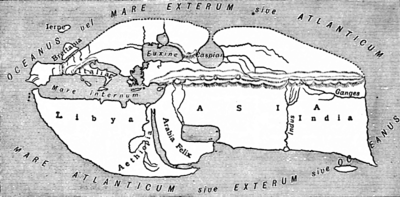
| 5–6 | The inhabited world is an island shaped like a truncated cone, in a spherical quadrilateral formed between the equator, the arctic circle and a great circle passing through the poles. The island is 70,000 stadia long by 30,000 stadia wide. | |
| 7 | Hipparchus says the equator is 252,000 stadia long; the great circle distance from equator to pole is 63,000 stadia. | |
| 8 | Strabo does not believe Pytheas that Thule is farthest north at the Arctic Circle. He thinks no one is north of Ierne. He believes the Romans scorned to invade Britain as being worthless. | |
| 9 | The length and width of the inhabited world are 70000 and 30000 stadia respectively. | |
| 10 | Strabo recommends representing the Earth on a globe of no less than 10 feet in diameter or on a plane map of at least 7 feet. | |
| 11–12 | Strabo says he personally travelled from Armenia to Tyrrhenia and from the Euxine Sea to the frontiers of Ethiopia. He and all other geographers receive information mostly by hearsay. He went up the Nile river with his friend Aelius Gallus, prefect of Egypt, to the edge of Ethiopia and Syene. | |
| 13–16 | The known limits of the Earth are Meroe in the Nile river, Ierne, the Sacred Promontory beyond the Pillars of Hercules and east of Bactriana. | |
| 17–18 | The sea determines the contours of the land. The four largest internal seas are the Caspian sea, the Persian Gulf, the Red Sea and the Mediterranean Sea. | |
| 19–25 | Mediterranean Sea. | |
| 26 | The continents are Europe, Libya, Asia. Europe develops excellence in men and government and has contributed the most to the others. | |
| 27–33 | States the locations of the countries of the three continents. | |
| 34 | Division of the circumference of the Earth, which is 252000 stadia, by 360 gives 700 stadia per section. | |
| 35–43 | Equator, Tropic circle, Arctic circle, latitude by the shadow of the gnomon and the length of the longest day. |
Book III – Iberian peninsula
Chapter 1 – Vicinity of the Sacred Cape
| Book | Section | Description |
|---|---|---|
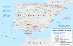
| III.1 | 1–3 | Ibēria is poor, inhospitable and mountainous, 6000 stadia N–S, 5000 E–W. The Purēnē oros is aligned N–S and separates Ibēria from Keltikē.[12] |
| 4 | The Sacred Cape is the westernmost point of the inhabited world.[13] The country next to it is called Cuneus, "wedge", in the Latin language from its shape. It is occupied by the Ibēres across the straits from the Maurousioi. | |
| 5 | Strabo repeats Poseidonius' assertion that the setting sun is larger at the coast because of a lens effect through the water vapor. He says Artemidorus is wrong in claiming a size of 100 times larger and that he could not have seen it because the cape was taboo at night. | |
| 6 | South West Iberia is delimited by the Tagus river (to the north of the Sacred Cape) and the Anas river to the east. The region is populated by the Keltikoi and some Lusitanai resettled there from beyond the Tagus by the Romans. Inland are the Karpētanoi (Madrid region), the Ōrētanoi (La Mancha and eastern Sierra Morena, and the Ouettōnoi (Salamanca region). The fertile southeast, Baetica (Andalusia region), east of the Baetis river after which it is named, is occupied by the Tourdētanoi or Tourdouloi, who have writing and a literature. Other Iberians have alphabets, but not the same, as they do not all use the same languages (glōttai). |
Chapter 2 – Bætica
| Book | Section | Description |
|---|---|---|
| III.2 | 1–2 | Bætica is the region around the Bætis river, main cities are Corduba and Gadira. |
| 3–5 | Bætis river is navigable and boats go from the sea to Corduba. | |
| 6 | Bætica soil is fertile, it exports a lot of wheat, wine, and oil. | |
| 7 | Bætica littoral is full of fish, especially fat tuna, which eat a lot of acorns like some "sea pigs". | |
| 8 | Bætica subsoil is full of gold, silver, cooper, and iron. | |
| 9–10 | How gold and silver are extracted from the soil of Baetica and other regions of Hispania. | |
| 11–13 | What Homer says about Bætica. | |
| 14–15 | Bætica was a Phœnician colony, now it's romanised. | |
Chapter 3
| Book | Section | Description |
|---|---|---|
| III | 1–8 | ... |
Chapter 4
| Book | Section | Description |
|---|---|---|
| III | 1–20 | ... |
Chapter 5
| Book | Section | Description |
|---|---|---|
| III | 1–1 | ... |
Book IV – Gaul, Britain, Ireland, Thule, the Alps
Book V – Italy to Campania
Book VI – south Italy, Sicily
Book VII – north, east and central Europe
Chapter 1 – Germania
| Book | Section | Description |
|---|---|---|
| VII | 1 | Overview of the lands to be covered in the rest of the text. |
| 2 | Germanic peoples. | |
| 3 | Geography of Germania, list of Germanic tribes. | |
| 4 | Roman conflicts with Germans. | |
| 5 | The Hercynian Forest, the Ister river. |
Chapter 2 – Germania
| Book | Section | Description |
|---|---|---|
| VII | 1 | Correcting false tales of the Cimbri. |
| 2 | Cimbri raids. | |
| 3 | Cimbri divination. | |
| 4 | Lack of knowledge of areas beyond Germany. |
Chapter 3 – northern Black Sea region
| Book | Section | Description |
|---|---|---|
| VII | 1 | Southern Germania, myths about distant regions. |
| 2 | The Mysians. | |
| 3 | Mysian culture and religion. | |
| 4 | Getae. Different views of their culture. | |
| 5 | Zalmoxis, his travels, and his influence on the Mysians. | |
| 6 | Errors in other Greek accounts of Mysia. | |
| 7–10 | The Scythians. | |
| 11–12 | The Getae. | |
| 13–19 | Danube river, Dacians, Thracians, Peucini, Dniester river, Dnepr river, Roxolani. |
Chapter 4
| Book | Section | Description |
|---|---|---|
| VII | 1–8 | Crimea |
Chapter 5
| Book | Section | Description |
|---|---|---|
| VII | 1–12 | Countries along the west bank of the Danube. |
Chapter 6
| Book | Section | Description |
|---|---|---|
| VII | 1–2 | Continuation of countries along the western and southern banks of the Danube (the Balkans). |
Chapter 7
| Book | Section | Description |
|---|---|---|
| VII | 1–2 | Continuation on the Balkans. |
Book VIII – Greece
| Book | Section | Description |
|---|---|---|
| VIII | 1.1 | Summary of previous chapters and intro to Greece |
| 1.2 | Greek tribes and dialects, Origins thereof | |
| 1.3 | Topography – coastline and peninsulas | |
| 3.9 | Epeians and Eleians peoples | |
| 3.12 | Temples and Shrines to various gods | |
| 3.17 | Cauconians, Origins thereof | |
| 3.30 | Olympia, legends thereof | |
| 4.11 | Depopulation of Laconia (area around Sparta) |
Book IX – More on Greece
Chapter 1 – Attica
Chapter 2 – Boeotia
Chapter 3 – Phocis
Chapter 4 – Locris
Chapter 5 – Thessaly
Book X – Yet more on Greece, Greek islands
Chapter 1 – Euboea
Chapter 2–3 – Aetolia and Acarnania
Chapter 4 – Crete
Chapter 5 – Archipelagos
Book XI – Russia east of the Don, the Transcaucasus, northwest Iran, Central Asia
Chapter 1–2 – East of the Don
Chapter 3 – Iberia
Chapter 4 – Albania
Chapter 5 – Armenia and Caucasus
Chapter 9 – Parthia
Chapter 10 – Aria and Margiana
Chapter 11 – Bactria
Book XII – Anatolia
Chapter 1–2 – Cappadocia
Chapter 3 – Pontus
Chapter 4 – Bithynia
Chapter 5–7 – Galatia, Lycaonia and Pisidia
Chapter 8 – Phrygia
Book XIII – northern Aegean
Book XIV – eastern Aegean
Book XV – Persia, Ariana, the Indian subcontinent
Book XVI – Middle East
Book XVII – North Africa
Chapter 1 – Nile, Egypt, Cyrenaica
| Book | Section | Description |
|---|---|---|
| 17 | 1–2 | Eratosthenes on the Nile and surrounding people. |
| 3 | The Nile in Ethiopia. The organization of Egypt, nomes, classes, comments on the Labyrinth. | |
| 4 | The Nile in the Nile Delta. | |
| 5 | Source of the Nile. Greek writers about the Nile. Definition of the name Aegypt. | |
| 6 | Harbours of Alexandria, Pharos Island. Julius Caesar. Founding of the city by Alexander the Great. | |
| 7 | Importance of Alexandria. Lake Mareotis. | |
| 8 | Details about Alexandria. Ptolemy I Soter steals Alexanders body. Perdiccas is slain. Roxana departes for Macedonia. | |
| 9 | Lighthouse of Alexandria. Other temples and buildings, Lochias (promontory), Royal palace, Antirrhodos (island), Theatre, Poseidium, Emporium, Timonium, Caesarium, Heptastadium. | |
| 10 | More details about Alexandria. More buildings and structures. The Sarapium. Emperor Augustus defeats Mark Antony. | |
| 11 | The Ptolemaic dynasty. | |
| 12–13 | Egypt as a Roman province. Roman Legions. Polybius' visit to Alexandria. | |
| 14 | Coastal cities from Cyrenaica to Alexandria. About wine. | |
| 15 | Papyrus, Cyperus and Cyperus papyrus in the Deltaic marshes and lakes. | |
| 16–17 | Road to Canopus. Temple of Sarapis. | |
| 18 | Nile mounts in the Delta, Canopic (Canopus), Bolbitine (Rosetta), Sebennytic (Buto), Phantnitic (Damietta), Mendesian (Mendes), Tanitic (Tanis) and Pelusiac (Pelusium). | |
| 19 | (sect. 19–21: Interior of the mouth of the river Nile; expulsion of foreigners; difficulty in entering Egypt.) cities Xoïs, Hermupolis, ... Mendes, ... | |
| 20 | Athribis ... Tanis | |
| 21 | Pelusium ... Heroönpolis | |
| 22 | Lake Mareia, ... | |
| 23 | ... Naucratis, Saïs | |
| 24 | discord among the Egyptians over the schoenus (i.e. a unit of distance) | |
| 25 | city of Arsinoê; canal through the Bitter Lakes to the Gulf of Suez | |
| 26 | Heroönpolis ... Phacussa | |
| 27–39 | ... | |
| 40 | Cynonpolis (‘City of Dogs’), ... ; overview of different animals worshipped by separate Egyptian groups or by all Egyptians in common | |
| 41 | Hermopolitic garrison, Thebaïc garrison, ... | |
| 42 | ... Abydus | |
| 43 | the oracle at Ammon visited by Alexander the Great | |
| 44 | temple of Osiris in Abydus; city of Tentyra | |
| 45 | cities Berenicê (at the Red Sea), Myus Hormus, Coptus ... ; mines of smaragdus | |
| 46 | Thebes | |
| 47 | city Hermonthis; a City of Crocodiles; a City of Aphroditê; Latopolis; a City of Hawks; Apollonospolis | |
| 48 | Syenê; Elephantinê; nilometer | |
| 49 | the First Cataract, above Elephantinê; settlement Philae, holding an Aethiopian bird in honour | |
| 50–54 | ... |
Chapter 2
| Book | Section | Description |
|---|---|---|
| 17 | 1–3 | Ethiopia |
| 4-5 | ... |
Chapter 3
| Book | Section | Description |
|---|---|---|
| 17 | 1–25 | ... |
Publications
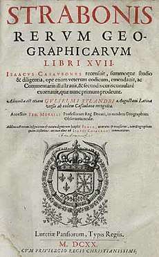
Some thirty manuscripts of Geographica or parts of it have survived, almost all of them medieval copies of copies, though there are fragments from papyrus rolls which were probably copied out c. 100–300 AD. Scholars have struggled for a century and a half to produce an accurate edition close to what Strabo wrote. A definitive one has been in publication since 2002, appearing at a rate of about a volume a year.[14]
References
- Dueck, Daniela (2000). Strabo of Amasia: A Greek Man of Letters in Augustan Rome. London, New York: Routledge: Taylor & Francis Group. p. 145. ISBN 0-415-21672-9.
- Book 3 chapter 1 section 1 1st sentence, page C136.
- Book 3 chapter 4 section 5 last sentence, page C158.
- Book 6 chapter 1 section 2, page C253.
- Book 9 chapter 5 section 14, page C435.
- Book 2 chapter 5 section 17, page C120, Jones translation.
- Ad. Att. 2. 6. 1.
- Sterrett, Loeb Edition, pages xxii–xxiii.
- Sterrett, Loeb Edition, page xxvii.
- Dueck page 146 on Strabo Book 4, Chapter 6, Book 9, page C206.
- Book I sections 22–23.
- Strabo rotates the Pyrenees to form the east side of Iberia, which is correspondingly distorted.
- In fact adjacent Cape St. Vincent is further west but Sagres Point was the Sacred Cape.
- "Print and online editions of the Greek text of Strabo's Geography". www.strabo.ca.
Editions
Ancient Greek
- Kramer, Gustav, ed., Strabonis Geographica, 3 vols, containing Books 1–17. Berlin: Friedericus Nicolaus, 1844–52.
Ancient Greek and English
- Strabo (1917–1932). Horace Leonard Jones (ed.). The Loeb Classical Library: The Geography of Strabo: in Eight Volumes. Translated by Jones; John Robert Sitlington Sterrett. Cambridge, Massachusetts/London: Harvard University Press/William Heinemann. ISBN 0-674-99055-2. Contains Books 1–17, Greek on the left page, English on the right. Sterrett translated Books I and II and wrote the introduction before dying in 1915. Jones changed Sterrett's style from free to more literal and finished the translation. The Introduction contains a major bibliography on all aspects of Strabo and a definitive presentation of the manuscripts and editions up until 1917.
French
- Tardieu, Amédée (1886). Géographie de Strabon: Traduction Nouvelle: Tome Premier (in French). Paris: Librairie Hachette. Books I – VI only.
- Tardieu, Amédée (1873). Géographie de Strabon: Traduction Nouvelle: Tome Deuxième (in French). Paris: Librairie Hachette. Books VII – XII only.
German
- Radt, Stefan (Translator, Critical Apparatus) (2002–2011) Strabons Geographika. Göttingen: Vandenhoeck & Ruprecht. Books I–XVII in ten volumes.
External links
- The text of Strabo online

- Strabo (1924). H.L. Jones (ed.). "Strabo: The Geography". LacusCurtius. Translated by Jones. Retrieved 2007-11-03.
- Strabo (1924). H.L. Jones (ed.). "Strabo, Geography". The Perseus Digital Library. Tufts University. Retrieved 2007-11-03. Books 6–14.
- Strabo (1903-06-19). H.C. Hamilton; W. Falconer (eds.). "Strabo, Geography". The Perseus Digital Library. Tufts University. Retrieved 2007-11-03.
- Strabo (1852–53). A. Meineke (ed.). "Strabo, Geography". The Perseus Digital Library (in Greek). Tufts University. Retrieved 2007-11-03. Books 6–14.
- Other links