Zagreb County
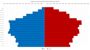
Zagreb County (Croatian: Zagrebačka županija) is a county in central Croatia. It surrounds – but does not contain – the nation's capital Zagreb, which is a separate territorial unit. For that reason, the county is often nicknamed "Zagreb ring" (Croatian: zagrebački prsten). According to the 2011 census, the county has 317,606 inhabitants, most of which live in smaller urban satellite towns.
Zagreb County Zagrebačka županija | |
|---|---|
 Flag  Coat of arms | |
 Zagreb County within Croatia | |
| Country | Croatia |
| County seat | Zagreb[1] |
| Government | |
| • Župan | Stjepan Kožić (Ind.) |
| • Assembly | 51 members
|
| Area | |
| • Total | 3,060 km2 (1,180 sq mi) |
| Population (2011)[3] | |
| • Total | 317,606 |
| • Density | 100/km2 (270/sq mi) |
| Area code | 01 |
| ISO 3166 code | HR-01 |
| HDI (2017) | 0.813[4] very high · 7th |
| Website | www |
.jpg)

_-_centar_grada.1.jpg)
The Zagreb County once included the city of Zagreb, but in 1997 they separated, when the City was given a special status.[5] Although separated from Zagreb City County both administratively and territorially, it still remains closely linked with it.
Zagreb County borders on Krapina-Zagorje County, the city of Zagreb, Varaždin County, and Koprivnica-Križevci County in the north, Bjelovar-Bilogora County in the east, Sisak-Moslavina County in the south and Karlovac County in the southwest.
Franjo Tuđman Airport is located on the territory of Zagreb County, the biggest and most important airport in the country.
Administrative divisions
Zagreb County is divided into 9 towns and 25 municipalities.
| Name | Population[3] | Area[6] |
|---|---|---|
| Dugo Selo | 17,466 | 52.22 km2 |
| Ivanić-Grad | 14,548 | 173.57 km2 |
| Jastrebarsko | 15,866 | 226.50 km2 |
| Samobor | 37,633 | 250.73 km2 |
| Sveta Nedelja | 18,059 | 41.43 km2 |
| Sveti Ivan Zelina | 15,959 | 184.68 km2 |
| Velika Gorica | 63,517 | 328.65 km2 |
| Vrbovec | 14,797 | 159.05 km2 |
| Zaprešić | 25,223 | 52.60 km2 |
| Name | Population[3] | Area[6] |
|---|---|---|
| Bedenica | 1,432 | 21.70 km2 |
| Bistra | 6,632 | 52.74 km2 |
| Brckovljani | 6,837 | 71.14 km2 |
| Brdovec | 11,134 | 37.27 km2 |
| Dubrava | 5,245 | 115.18 km2 |
| Dubravica | 1,437 | 20.46 km2 |
| Farkaševac | 1,937 | 73.66 km2 |
| Gradec | 3,681 | 88.85 km2 |
| Jakovlje | 3,930 | 35.71 km2 |
| Klinča Sela | 5,231 | 77.64 km2 |
| Kloštar Ivanić | 6,091 | 77.59 km2 |
| Krašić | 2,640 | 69.40 km2 |
| Kravarsko | 1,987 | 58.03 km2 |
| Križ | 6,963 | 118.46 km2 |
| Luka | 1,351 | 17.17 km2 |
| Marija Gorica | 2,233 | 17.10 km2 |
| Orle | 1,975 | 57.61 km2 |
| Pisarovina | 3,689 | 145.00 km2 |
| Pokupsko | 2,224 | 105.73 km2 |
| Preseka | 1,448 | 47.86 km2 |
| Pušća | 2,700 | 18.20 km2 |
| Rakovec | 1,252 | 35.11 km2 |
| Rugvica | 7,871 | 93.73 km2 |
| Stupnik | 3,735 | 23.20 km2 |
| Žumberak | 883 | 110.17 km2 |
County government
Current Župan: Stjepan Kožić (HSS)
The county assembly is composed of 45 representatives, organized as follows:[7]
- Croatian Democratic Union (HDZ)/Croatian Peasants Party (HSS)/ HSU - 21
- Social Democratic Party of Croatia (SDP)/Croatian People's Party (HNS)/ Democratic Centre (DC) / HSLS - 19
- SU - 3
- HSP - 2
See also
- Zagreb County (former)
- Category:Former counties of Croatia
References
- http://www.zagrebacka-zupanija.hr/o_zagrebackoj_zupaniji
- Ostroški, Ljiljana, ed. (December 2015). Statistički ljetopis Republike Hrvatske 2015 [Statistical Yearbook of the Republic of Croatia 2015] (PDF). Statistical Yearbook of the Republic of Croatia (in Croatian and English). 47. Zagreb: Croatian Bureau of Statistics. p. 62. ISSN 1333-3305. Retrieved 27 December 2015.
- "Population by Age and Sex, by Settlements, 2011 Census: County of Zagreb". Census of Population, Households and Dwellings 2011. Zagreb: Croatian Bureau of Statistics. December 2012.
- "Sub-national HDI - Area Database - Global Data Lab". hdi.globaldatalab.org. Retrieved 2018-09-13.
- Narodne novine, br. 62/01, 125/08
- "Sustav središnjih naselja i razvojnih središta" (in Croatian). Prosorni plan Zagrebačke županije. Archived from the original on 2008-09-13. Retrieved 2008-09-21.
- "2009 Elections - zagreb County, results". Archived from the original on 2009-06-07. Retrieved 2009-06-04.
External links
- Zagrebačka županija Official website
- Zagreb county tourist board
Subdivisions of Zagreb County | ||
|---|---|---|
| Towns |  Coat of arms of Zagreb County | |
| Municipalities | ||