Saint-Véran
Saint-Véran (occitan : Sant-Veran [ˈsã vˈʀã]) is a commune in the Hautes-Alpes department in southeastern France in the Queyras Regional Natural Park.
Saint-Véran | |
|---|---|
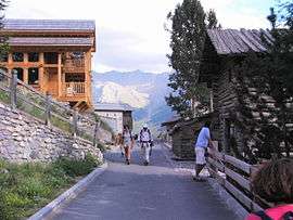 A view within Saint-Véran, in August 2008 | |
 Coat of arms | |
Location of Saint-Véran 
| |
 Saint-Véran  Saint-Véran | |
| Coordinates: 44°42′03″N 6°52′09″E | |
| Country | France |
| Region | Provence-Alpes-Côte d'Azur |
| Department | Hautes-Alpes |
| Arrondissement | Briançon |
| Canton | Guillestre |
| Intercommunality | Queyras |
| Government | |
| • Mayor (2008–2014) | Danielle Guignard |
| Area 1 | 44.75 km2 (17.28 sq mi) |
| Population (2017-01-01)[1] | 236 |
| • Density | 5.3/km2 (14/sq mi) |
| Time zone | UTC+01:00 (CET) |
| • Summer (DST) | UTC+02:00 (CEST) |
| INSEE/Postal code | 05157 /05350 |
| Elevation | 1,756–3,175 m (5,761–10,417 ft) (avg. 2,040 m or 6,690 ft) |
| 1 French Land Register data, which excludes lakes, ponds, glaciers > 1 km2 (0.386 sq mi or 247 acres) and river estuaries. | |
Geography
Saint-Véran, located in the French Alps, is the most elevated commune in France.[2] It is the third highest village in Europe, after Trepalle in Italy and Juf in Switzerland.
The permanent population is around 300 but swells with tourists in both summer and winter. In addition to tourism the main activities are agriculture and woodcraft.
Name
The village is named after Saint Véran, 6th century Bishop of Cavaillon who in legend drove away a dragon.
The Observatoire de Saint-Véran was constructed nearby by the Observatoire de Paris in the early 1970s.
Population
| Historical population | ||
|---|---|---|
| Year | Pop. | ±% |
| 1962 | 236 | — |
| 1968 | 220 | −6.8% |
| 1975 | 232 | +5.5% |
| 1982 | 275 | +18.5% |
| 1990 | 257 | −6.5% |
| 1999 | 267 | +3.9% |
| 2008 | 282 | +5.6% |
References
- "Populations légales 2017". INSEE. Retrieved 6 January 2020.
- Page 505, Chapter Hautes Alpes, book France, Collection Guide vert, publisher Le Michelin, 2009
External links
| Wikimedia Commons has media related to Saint-Véran. |
This article is issued from Wikipedia. The text is licensed under Creative Commons - Attribution - Sharealike. Additional terms may apply for the media files.