French Alps
The French Alps are the portions of the Alps mountain range that stand within France, located in the Auvergne-Rhône-Alpes and Provence-Alpes-Côte d'Azur regions. While some of the ranges of the French Alps are entirely in France, others, such as the Mont Blanc massif, are shared with Switzerland and Italy.
| French Alps | |
|---|---|
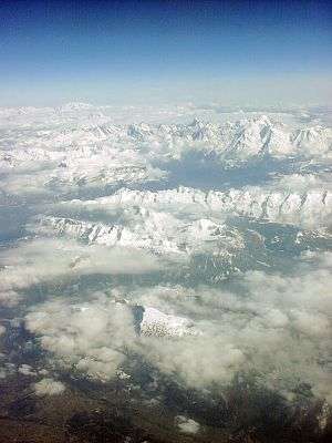 Aerial photograph of the Mont Blanc massif, the tallest mountain in the French Alps, seen from the west | |
| Highest point | |
| Peak | Mont Blanc |
| Elevation | 4,810.45 m (15,782.3 ft) |
| Coordinates | 45°50′01″N 06°51′54″E |
| Geography | |
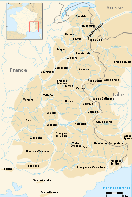 Ranges of the French Alps.
| |
| French regions | Auvergne-Rhône-Alpes and Provence-Alpes-Côte d'Azur |
| Borders on | Swiss Alps, Italian Alps |
| Geology | |
| Orogeny | Alpine orogeny |
| Age of rock | Tertiary |
| Type of rock | Bündner schist, flysch and molasse |
At 4,808 metres (15,774 ft), Mont Blanc (Italian: Monte Bianco), on the French-Italian border, is the highest mountain in the Alps, and the highest Western European mountain.[1]
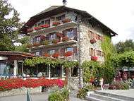
Notable towns in the French Alps include Grenoble, Chamonix, Annecy, Chambéry, Évian-les-Bains and Albertville.
Ranges and summits
| Chain | Range | Highest summit | Elevation (m/ft) |
|---|---|---|---|
| Graian Alps | Mont Blanc Massif | Mont Blanc | 4,810.45 metres (15,782 ft) |
| Graian Alps | Beaufortain Massif | Roignais | 2,995 metres (9,826 ft) |
| Graian Alps | Lauzière Massif | Grand Pic de la Lauzière | 2,829 metres (9,281 ft) |
| Graian Alps | Vanoise Massif | Grande Casse | 3,855 metres (12,648 ft) |
| Graian Alps | Graian Alps central group | Pointe de Charbonnel | 3,752 metres (12,310 ft) |
| Dauphiné Alps | Belledonne Massif | Grand Pic de Belledonne | 2,977 metres (9,767 ft) |
| Dauphiné Alps | Grandes Rousses | Pic Bayle | 3,465 metres (11,368 ft) |
| Dauphiné Alps | Arves Massif | Aiguilles d'Arves | 3,514 metres (11,529 ft) |
| Dauphiné Alps | Taillefer Massif | Le Taillefer | 2,857 metres (9,373 ft) |
| Dauphiné Alps | Écrins Massif | Barre des Écrins | 4,102 metres (13,458 ft) |
| Cottian Alps | Massif du Mont-Cenis | Pointe de Ronce | 3,612 metres (11,850 ft) |
| Cottian Alps | Cerces Massif | Grand Galibier | 3,229 metres (10,594 ft) |
| Cottian Alps | Queyras Massif | Rochebrune Peak | 3,320 metres (10,892 ft) |
| Cottian Alps | Ubaye Massif (Orrenaye) | Aiguille de Chambeyron | 3,411 metres (11,191 ft) |
| Maritime Alps | Mercantour Massif | Cime du Gélas | 3,143 metres (10,312 ft) |
| Maritime Alps | Pelat Massif | Mont Pelat | 3,050 metres (10,007 ft) |
| Maritime Alps | Massif des Trois-Évêchés | Tête de l'Estrop | 2,961 metres (9,715 ft) |
| Ligurian Alps | Ligurian Alps | Punta Marguareis | 2,651 metres (8,698 ft) |
| Savoy Prealps | Chablais Alps | Hauts-Forts | 2,464 metres (8,084 ft) |
| Savoy Prealps | Haut-Giffre Massif | Haute Cime | 3,257 metres (10,686 ft) |
| Savoy Prealps | Aiguilles Rouges | Aiguille du Belvédère | 2,965 metres (9,728 ft) |
| Savoy Prealps | Bornes | Pointe Blanche | 2,438 metres (7,999 ft) |
| Savoy Prealps | Aravis Range | Pointe Percée | 2,750 metres (9,022 ft) |
| Savoy Prealps | Bauges | Arcalod | 2,217 metres (7,274 ft) |
| Savoy Prealps | Chartreuse Mountains | Chamechaude | 2,082 metres (6,831 ft) |
| Dauphiné Prealps | Vercors Massif | Grand Veymont | 2,341 metres (7,680 ft) |
| Dauphiné Prealps | Diois Mountains | Mont Jocou | 2,051 metres (6,729 ft) |
| Dauphiné Prealps | Dévoluy Mountains | Grande Tête de l'Obiou | 2,789 metres (9,150 ft) |
| Provence Prealps | Bochaine | Mont Céüse | 2,016 metres (6,614 ft) |
| Provence Prealps | Digne Prealps | Les Monges | 2,115 metres (6,939 ft) |
| Provence Prealps | Baronnies | Mont Mare | 1,603 metres (5,259 ft) |
| Provence Prealps | Vaucluse Mountains | Signal de Saint-Pierre | 1,256 metres (4,121 ft) |
| Provence Prealps | Luberon Mountains | Mourre Nègre | 1,125 metres (3,691 ft) |
| Maritime Prealps | Castellan Prealps | Puy de Rent | 1,996 metres (6,549 ft) |
| Maritime Prealps | Nice Prealps | Pointe des Trois Communes | 2,080 metres (6,824 ft) |
Ski areas
The largest connected ski areas are:
- Les Trois Vallées (Courchevel, Méribel, La Tania, Brides-les-Bains, Saint-Martin-de-Belleville, Les Menuires, Val Thorens and Orelle): 338 slopes, 600 km of pistes.
- Portes du Soleil (Avoriaz, Châtel, Morzine, Les Gets, Saint-Jean d'Aulps, La Chapelle d'Abondance, Abondance, Montriond, Swiss resorts): 288 slopes, 650 km of slopes not entirely connected.
- Paradiski (La Plagne, Peisey-Vallandry, Les Arcs), Champagny-en-Vanoise: 239 slopes, 420 km of slopes.
- Via Lattea (Montgenèvre, Italian resorts): 214 slopes, 400 km of slopes.
- Évasion Mont-Blanc (Combloux, Megève, Saint-Gervais, Saint-Nicolas-de-Véroce, Les Contamines Monjoie): 183 slopes, 420 km of slopes not entirely connected.
- Espace Killy (Tignes, Val-d'Isère): 137 slopes, 300 km of slopes.
- Grand Massif (Flaine, Les Carroz, Morillon, Samoëns, Sixt): 134 slopes, 265 km of slopes.
- Les Aravis (La Clusaz, Manigod, La Croix Fry, Merdassier, Le Grand-Bornand): 133 slopes, 220 km of slopes not entirely connected.
- Les Grandes Rousses (L'Alpe d'Huez, Vaujany, Auris-en-Oisans, Oz-en-Oisans, Villard-Reculas): 117 slopes, 236 km of slopes.
- Serre Chevalier: 111 slopes, 250 km of slopes.
- La Forêt Blanche (Risoul, Vars): 104 slopes, 180 km of slopes.
- Les Sybelles (Le Corbier, La Toussuire, Les Bottières, Saint-Jean-d'Arves, Saint-Sorlin-d'Arves, Saint-Colomban-des-Villards): 96 slopes, 310 km of slopes.
- Valloire and Valmeinier: 83 slopes, 150 km of slopes.
- Grand Domaine (Valmorel, Saint-François-Longchamp): 82 slopes, 150 km of slopes
- Espace San Bernardo (La Rosière, La Thuile - Italy): 73 slopes, 150 km of slopes.
- Les Deux Alpes and La Grave: 69 slopes, 220 km of slopes. (+ Freeride Zone)
The other large ski areas are:
- Le Val d'Arly (Praz-sur-Arly, Notre-Dame-de-Bellecombe, Flumet): 150 km of slopes.
- L'Espace Cristal (Les Saisies, Crest-Voland): 80 km of slopes
- L'Espace Diamant is a combination of Espace Val d'Arly and Espace Cristal with 185 km of slopes
- Villard-de-Lans et Corrençon-en-Vercors: 125 km of slopes
- Valberg - Beuil les Launes: 90 km of slopes
- Espace Lumière (Pra-Loup, Val d'Allos): 170 km of slopes
- Superdévoluy - La Joue du Loup: 100 km of slopes
- Orcières-Merlette 150 km of slopes
Activities
A range of winter and summer activities are available in the French Alps. In the winter, these include skiing and snowboarding as well as alternatives such as snowshoeing, sledging. There is a range of other activities that happen such as gliding which most happens during the summer months.[2] Summer activities include hiking, mountaineering, biking and rock climbing.[3]
Gallery
 Mont Blanc (4,810 m)
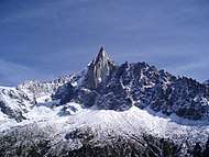 Aiguille du Dru (3,754 m)
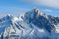 Aiguille Verte (4,122 m)
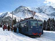 Tramway du Mont-Blanc, at Bellevue Station (1,794 m) in Saint-Gervais-les-Bains
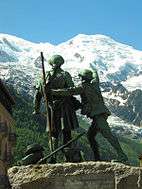 Jacques Balmat at the side of Horace-Benedict de Saussure, "The Father of Alpinism", in a monument erected at Chamonix
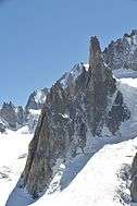 Grand Capucin (3,838 m) and its 400-meter vertical face
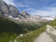


 Chalet in the medieval city of Yvoire
 Palais de l'Isle in Annecy
See also
References
| Wikivoyage has a travel guide for French Alps. |
| Wikimedia Commons has media related to Alps of France. |
- Mont Blanc shrinks by 45cm in two years
- "frenchalps.co.uk - Your website dedicated to information on the French Alps". frenchalps.co.uk. Retrieved 2016-01-27.
- "French Alps Mountain Activities | frenchalps.co.uk". frenchalps.co.uk. Retrieved 2016-01-27.
- Raoul Blanchard (1938–1956), Les Alpes Occidentales. Paris: Édition Arthaud. (French)
- Roger Frison-Roche (1964), Les montagnes de la terre. Paris: Flammarion. (French)
- Sergio Marazzi (2005), Atlante Orografico delle Alpi. SOIUSA. Pavone Canavese (TO): Priuli & Verlucca editori. ISBN 978-88-8068-273-8 (Italian)
- Sergio Marazzi, La "Suddivisione orografica internazionale unificata del Sistema Alpino" (SOIUSA) - article with maps and illustrations, PDF (Italian)