Monêtier-Allemont
Monêtier-Allemont is a commune in the Hautes-Alpes department in southeastern France.
Monêtier-Allemont | |
|---|---|
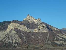 The Pic de Crigne from the east, in the commune of Monêtier-Allemont | |
 Coat of arms | |
Location of Monêtier-Allemont 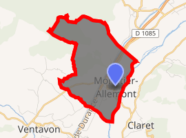
| |
 Monêtier-Allemont  Monêtier-Allemont | |
| Coordinates: 44°23′12″N 5°56′37″E | |
| Country | France |
| Region | Provence-Alpes-Côte d'Azur |
| Department | Hautes-Alpes |
| Arrondissement | Gap |
| Canton | Laragne-Montéglin |
| Intercommunality | Laragne |
| Government | |
| • Mayor (2008–2014) | Henri Mevolhon |
| Area 1 | 7.15 km2 (2.76 sq mi) |
| Population (2017-01-01)[1] | 283 |
| • Density | 40/km2 (100/sq mi) |
| Time zone | UTC+01:00 (CET) |
| • Summer (DST) | UTC+02:00 (CEST) |
| INSEE/Postal code | 05078 /05110 |
| Elevation | 530–1,373 m (1,739–4,505 ft) (avg. 558 m or 1,831 ft) |
| 1 French Land Register data, which excludes lakes, ponds, glaciers > 1 km2 (0.386 sq mi or 247 acres) and river estuaries. | |
Population
| Historical population | ||
|---|---|---|
| Year | Pop. | ±% |
| 1962 | 260 | — |
| 1968 | 285 | +9.6% |
| 1975 | 286 | +0.4% |
| 1982 | 240 | −16.1% |
| 1990 | 228 | −5.0% |
| 1999 | 265 | +16.2% |
| 2008 | 321 | +21.1% |
References
- "Populations légales 2017". INSEE. Retrieved 6 January 2020.
| Wikimedia Commons has media related to Monêtier-Allemont. |
This article is issued from Wikipedia. The text is licensed under Creative Commons - Attribution - Sharealike. Additional terms may apply for the media files.