Guillestre
Guillestre (Vivaro-Alpine: Guilhèstra) is a commune in the Hautes-Alpes department in southeastern France.
Guillestre | |
|---|---|
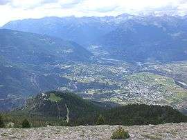 A panoramic view of Guillestre to the right, and the village of Risoul, left | |
 Coat of arms | |
Location of Guillestre 
| |
 Guillestre  Guillestre | |
| Coordinates: 44°40′N 6°39′E | |
| Country | France |
| Region | Provence-Alpes-Côte d'Azur |
| Department | Hautes-Alpes |
| Arrondissement | Briançon |
| Canton | Guillestre |
| Intercommunality | Guillestre |
| Government | |
| • Mayor (2014–2020) | Bernard Leterrier[1] |
| Area 1 | 51.29 km2 (19.80 sq mi) |
| Population (2017-01-01)[2] | 2,344 |
| • Density | 46/km2 (120/sq mi) |
| Time zone | UTC+01:00 (CET) |
| • Summer (DST) | UTC+02:00 (CEST) |
| INSEE/Postal code | 05065 /05600 |
| Elevation | 867–2,694 m (2,844–8,839 ft) (avg. 1,050 m or 3,440 ft) |
| 1 French Land Register data, which excludes lakes, ponds, glaciers > 1 km2 (0.386 sq mi or 247 acres) and river estuaries. | |
Geography
The village lies in the northwestern part of the commune, on the left bank of the Chagne, a stream, tributary of the Guil, which forms all of the commune's northern border, before flowing into the Durance, which forms part of the commune's western border. The village also lies high within the alps of France.
Population
| Historical population | ||
|---|---|---|
| Year | Pop. | ±% |
| 1962 | 1,448 | — |
| 1968 | 1,479 | +2.1% |
| 1975 | 1,466 | −0.9% |
| 1982 | 1,937 | +32.1% |
| 1990 | 2,000 | +3.3% |
| 1999 | 2,211 | +10.5% |
| 2008 | 2,290 | +3.6% |
| 2012 | 2,367 | +3.4% |
References
- "List of mayors of the Hautes-Alpes department". Prefecture of Hautes-Alpes (in French). 3 June 2014. Archived from the original on 10 January 2015. Retrieved 20 March 2015.
- "Populations légales 2017". INSEE. Retrieved 6 January 2020.
| Wikimedia Commons has media related to Guillestre. |
| Authority control |
|
|---|
This article is issued from Wikipedia. The text is licensed under Creative Commons - Attribution - Sharealike. Additional terms may apply for the media files.