Freissinières
Freissinières is a commune in the Hautes-Alpes department in southeastern France.
Freissinières | |
|---|---|
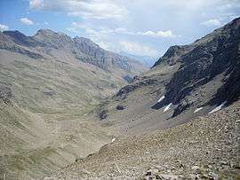 Valley of Chichin | |
Location of Freissinières 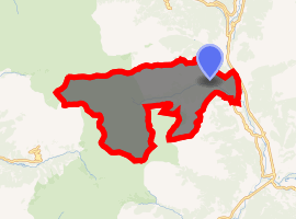
| |
 Freissinières  Freissinières | |
| Coordinates: 44°45′18″N 6°32′16″E | |
| Country | France |
| Region | Provence-Alpes-Côte d'Azur |
| Department | Hautes-Alpes |
| Arrondissement | Briançon |
| Canton | L'Argentière-la-Bessée |
| Intercommunality | Pays des Écrins |
| Government | |
| • Mayor (2008–2014) | Cyrille Drujon d'Astros |
| Area 1 | 88.21 km2 (34.06 sq mi) |
| Population (2017-01-01)[1] | 210 |
| • Density | 2.4/km2 (6.2/sq mi) |
| Time zone | UTC+01:00 (CET) |
| • Summer (DST) | UTC+02:00 (CEST) |
| INSEE/Postal code | 05058 /05310 |
| Elevation | 936–3,236 m (3,071–10,617 ft) (avg. 1,190 m or 3,900 ft) |
| 1 French Land Register data, which excludes lakes, ponds, glaciers > 1 km2 (0.386 sq mi or 247 acres) and river estuaries. | |
Geography
Freissinières lies in a valley which is the watershed of the Biaysse, which flows into the Durance between La Roche-de-Rame and Saint-Crépin.
From east to west, it consists of an alluvial plain of about 80 hectares, bordered on the south by a forest of conifers. On the north, the terrain is arid and rocky. However, vineyards were planted there up to 1200 m.
Near the hamlet of Meyries, the valley widens to the north, with a deciduous forest. The part of the valley called la Poua, exposed to the south, was well cultivated up to the pastures near the col d'Anon.
After the hamlet of Ribes, the valley narrows along the course of the Biaysse to the bottom of the valley. Here, the soil is poor; avalanches and mudslides have covered the soil with rocks and gravel. The two little hamlets of Viollins and Mensals are situated in rare protected spots.
Then, the Biaysse cascades down to the hamlet of Dormillouse at 1727 m. There the valley divides in two, with the lakes of Faravel and Palluel. This sector is dominated by the peaks of Félix Neff (3243 m), Grand Pinier (3117 m), and Petit Pinier (3100 m), which are part of the Parc national des Écrins. South of the hamlet of Viollins, the beautiful mountain of Val-Haute, is dominated by the Tête de Vautisse (3156 m).
In 2010 in the Parc National des Ecrins, Freissinières, a high altitude rock shelter with prehistoric rock paintings of animals was discovered.[2]
Population
| Historical population | ||
|---|---|---|
| Year | Pop. | ±% |
| 1690 | 850 | — |
| 1796 | 688 | −19.1% |
| 1826 | 935 | +35.9% |
| 1876 | 792 | −15.3% |
| 1901 | 618 | −22.0% |
| 1916 | 591 | −4.4% |
| 1931 | 454 | −23.2% |
| 1962 | 148 | −67.4% |
| 1968 | 216 | +45.9% |
| 1975 | 199 | −7.9% |
| 1982 | 172 | −13.6% |
| 1990 | 167 | −2.9% |
| 1999 | 169 | +1.2% |
| 2008 | 187 | +10.7% |
References
- "Populations légales 2017". INSEE. Retrieved 6 January 2020.
- Walsh, K. et al. (2016). Interpreting the Rock Paintings of Abri Faravel: laser and white-light scanning at 2,133m in the southern French Alps, Internet Archaeology 42. Retrieved 26 May 2016
External links
| Wikimedia Commons has media related to Freissinières. |
| Authority control |
|
|---|