Red Slate Mountain
Red Slate Mountain is a summit in the Sierra Nevada. It lies along the Sierra Crest that divides Fresno County from Mono County, California.
| Red Slate Mountain | |
|---|---|
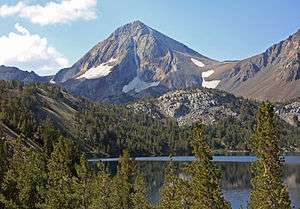 Red Slate Mountain from Lake Dorothy | |
| Highest point | |
| Elevation | 13,129+ ft (4,002+ m) NAVD 88[1] |
| Prominence | 1,683 ft (513 m) [1] |
| Parent peak | Ruby Peak[2] |
| Listing |
|
| Coordinates | 37°30′27″N 118°52′09″W [4] |
| Geography | |
| Location | Fresno / Mono counties, California, U.S. |
| Parent range | Sierra Nevada |
| Topo map | USGS Convict Lake |
| Geology | |
| Age of rock | Paleozoic |
| Mountain type | Metamorphic rock |
| Climbing | |
| First ascent | 1898 by Joseph N. LeConte and Clarence L. Cory[5] |
| Easiest route | Scramble, class 1 & 2[6] |
Red Slate Mountain can be reached by scrambling either from McGee Pass, or starting from Bighorn Lake.
The area to the north of Red Slate Mountain is among the most seismically active in California which is associated with the Long Valley Caldera.
Red Slate Mountain was named by the California Geological Survey, in 1873. However, it is not clear whether the survey meant to name this peak, or Red and White Mountain.[5]
See also
References
- "Red Slate Mountain, California". Peakbagger.com. Retrieved 2008-11-28.
- "Red Slate Mountain". ListsOfJohn.com. Retrieved 2011-06-03.
- "Western States Climbers List". Climber.org. Retrieved 2016-03-24.
- "Red Slate Mountain". NGS data sheet. U.S. National Geodetic Survey. Retrieved 2008-11-28.
- Farquhar, Francis P. (1926). Place Names of the High Sierra. San Francisco: Sierra Club. Retrieved 2008-11-28.
- Roper, Steve (1976). The Climber's Guide to the High Sierra. San Francisco: Sierra Club Books. p. 130. ISBN 9780871561473.
External links

- "Red Slate Mountain". Geographic Names Information System. United States Geological Survey.
- "Red Slate Mountain". SummitPost.org.

This article is issued from Wikipedia. The text is licensed under Creative Commons - Attribution - Sharealike. Additional terms may apply for the media files.