Wind River Peak
Wind River Peak (13,197 feet (4,022 m)) is the highest point in the southern end of the Wind River Range that is located in the U.S. state of Wyoming. The peak straddles the Continental Divide and is surrounded by National Forest lands.[3] The west slopes are in the Bridger Wilderness of Bridger-Teton National Forest, while the east side is in the Popo Agie Wilderness of Shoshone National Forest. In a cirque on the northeast slopes of the peak lies Wind River Glacier.[3]
| Wind River Peak | |
|---|---|
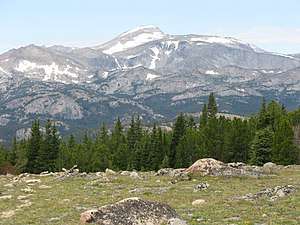 Wind River Peak (center) seen from a distance in July 2010. | |
| Highest point | |
| Elevation | 13,197 ft (4,022 m) [1] |
| Prominence | 2,552 ft (778 m) [1] |
| Listing | |
| Coordinates | 42°42′31″N 109°07′41″W [2] |
| Geography | |
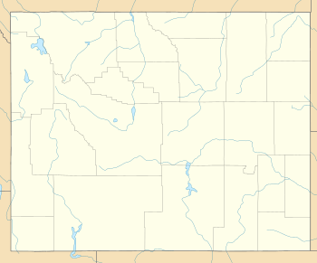 Wind River Peak Location in Wyoming  Wind River Peak Location in the United States | |
| Location | Fremont / Sublette counties, Wyoming, U.S. |
| Parent range | Wind River Range |
| Topo map | USGS Temple Peak |
| Climbing | |
| First ascent | 1873, Theodore Comstock, L. Hardy |
| Easiest route | Hike, scramble |
Hazards

Encountering bears is a concern in the Wind River Range.[4] There are other concerns as well, including bugs, wildfires, adverse snow conditions and nighttime cold temperatures.[5]
Importantly, there have been notable incidents, including accidental deaths, due to falls from steep cliffs (a misstep could be fatal in this class 4/5 terrain) and due to falling rocks, over the years, including 1993,[6] 2007 (involving an experienced NOLS leader),[7] 2015[8] and 2018.[9] Other incidents include a seriously injured backpacker being airlifted near SquareTop Mountain[10] in 2005,[11] and a fatal hiker incident (from an apparent accidental fall) in 2006 that involved state search and rescue.[12] The U.S. Forest Service does not offer updated aggregated records on the official number of fatalities in the Wind River Range.
See also
- 4000 meter peaks of North America
- Central Rocky Mountains
References
- "Wind River Peak, Wyoming". Peakbagger.com. Retrieved October 5, 2014.
- "Wind River Peak". Geographic Names Information System. United States Geological Survey. Retrieved October 5, 2014.
- Temple Peak, WY (Map). TopoQwest (United States Geological Survey Maps). Retrieved October 5, 2014.
- Staff (April 24, 2017). "Bear Safety in Wyoming's Wind River Country". WindRiver.org. Retrieved February 17, 2019.
- Ballou, Dawn (July 27, 2005). "Wind River Range condition update - Fires, trails, bears, Continental Divide". PineDaleOnline News. Retrieved February 17, 2019.
- Staff (1993). "Falling Rock, Loose Rock, Failure to Test Holds, Wyoming, Wind River Range, Seneca Lake". American Alpine Club. Retrieved February 15, 2019.
- MacDonald, Dougald (August 14, 2007). "Trundled Rock Kills NOLS Leader". Climbing. Retrieved February 15, 2019.
- Staff (December 9, 2015). "Officials rule Wind River Range climbing deaths accidental". Casper Star-Tribune. Retrieved February 15, 2019.
- Dayton, Kelsey (August 24, 2018). "Deadly underestimation". WyoFile News. Retrieved February 15, 2019.
- Funk, Jason (2009). "Squaretop Mountain Rock Climbing". Mountain Project. Retrieved March 29, 2019.
- Staff (July 22, 2005). "Injured man rescued from Square Top Mtn - Tip-Top Search & Rescue helps 2 injured on the mountain". PineDaleOnline News. Retrieved February 17, 2019.
- Staff (September 1, 2006). "Incident Reports - September, 2006 - Wind River Search". WildernessDoc.com. Retrieved February 17, 2019.