Rayle, Georgia
Rayle is a town in Wilkes County, Georgia, United States. The population was 139 at the 2000 census.
Rayle, Georgia | |
|---|---|
 Location in Wilkes County and the state of Georgia | |
| Coordinates: 33°47′25″N 82°53′48″W | |
| Country | United States |
| State | Georgia |
| County | Wilkes |
| Area | |
| • Total | 1.04 sq mi (2.70 km2) |
| • Land | 1.02 sq mi (2.65 km2) |
| • Water | 0.02 sq mi (0.05 km2) |
| Elevation | 702 ft (214 m) |
| Population (2010) | |
| • Total | 199 |
| • Estimate (2018)[2] | 185 |
| • Density | 180.66/sq mi (69.73/km2) |
| Time zone | UTC-5 (Eastern (EST)) |
| • Summer (DST) | UTC-4 (EDT) |
| ZIP code | 30660 |
| Area code(s) | 706 |
| FIPS code | 13-63756[3] |
| GNIS feature ID | 0332801[4] |
Geography
Rayle is located at 33°47′25″N 82°53′48″W (33.790184, -82.896599).[5]
According to the United States Census Bureau, the town has a total area of 0.9 square miles (2.3 km2), all land.
Demographics
| Historical population | |||
|---|---|---|---|
| Census | Pop. | %± | |
| 1970 | 110 | — | |
| 1980 | 177 | 60.9% | |
| 1990 | 107 | −39.5% | |
| 2000 | 139 | 29.9% | |
| 2010 | 199 | 43.2% | |
| Est. 2018 | 185 | [2] | −7.0% |
| U.S. Decennial Census[6] | |||
At the 2000 census there were 139 people, 54 households, and 38 families living in the town. The population density was 151.3 people per square mile (58.3/km²). There were 61 housing units at an average density of 66.4 per square mile (25.6/km²). The racial makeup of the town was 79.14% White, 15.83% African American, 0.72% Native American, 2.16% from other races, and 2.16% from two or more races. Hispanic or Latino of any race were 3.60%.[3]
Of the 54 households 29.6% had children under the age of 18 living with them, 59.3% were married couples living together, 9.3% had a female householder with no husband present, and 29.6% were non-families. 27.8% of households were one person and 5.6% were one person aged 65 or older. The average household size was 2.46 and the average family size was 3.03.
The age distribution was 25.9% under the age of 18, 5.0% from 18 to 24, 28.1% from 25 to 44, 26.6% from 45 to 64, and 14.4% 65 or older. The median age was 39 years. For every 100 females, there were 113.8 males. For every 100 females age 18 and over, there were 114.6 males.
The median household income was $33,229 and the median family income was $33,542. Males had a median income of $31,458 versus $16,667 for females. The per capita income for the town was $15,160. There were 15.8% of families and 26.3% of the population living below the poverty line, including 55.0% of under eighteens and 18.8% of those over 64.
See also
References
- "2018 U.S. Gazetteer Files". United States Census Bureau. Retrieved Feb 12, 2020.
- "Population and Housing Unit Estimates". Retrieved June 4, 2019.
- "U.S. Census website". United States Census Bureau. Retrieved 2008-01-31.
- "US Board on Geographic Names". United States Geological Survey. 2007-10-25. Retrieved 2008-01-31.
- "US Gazetteer files: 2010, 2000, and 1990". United States Census Bureau. 2011-02-12. Retrieved 2011-04-23.
- "Census of Population and Housing". Census.gov. Retrieved June 4, 2015.
Municipalities and communities of Wilkes County, Georgia, United States | ||
|---|---|---|
| City | 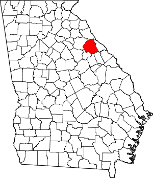 Map of Georgia highlighting Wilkes County | |
| Towns | ||
| Unincorporated communities | ||
| Ghost town | ||
| Authority control |
|
|---|