Redding, California
Redding is a city in and the county seat of Shasta County, California, United States, in the northern part of the state. It lies along the Sacramento River, 162 miles (261 kilometers) north of Sacramento, and 120 miles (190 km) south of California's northern border, shared with the state of Oregon. Interstate 5 bisects the entire city, from the south to north before it approaches Shasta Lake, which is located 15 miles (24 km) to the north. The 2010 population was 90,322.[5][6] Redding is the largest city in the Shasta Cascade region, and it is the sixth-largest city in the Sacramento Valley, behind Chico, Sacramento, Elk Grove, Roseville, and Vacaville.
Redding, California | |
|---|---|
City in California | |
| City of Redding | |
.jpg) | |
 Flag  Seal | |
| Nickname(s): "The Jewel of Northern California"[1] | |
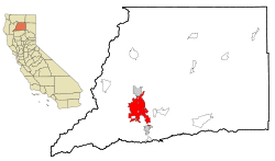 Location of Redding in Shasta County, California | |
 Redding Location in the United States  Redding Redding (the United States) | |
| Coordinates: 40°35′N 122°22′W | |
| Country | |
| State | |
| County | Shasta |
| Incorporated | October 4, 1887 |
| Founded by | Pierson B. Reading |
| Government | |
| • Type | Council-manager |
| • City council | Mayor Adam McElvain Vice Mayor Erin Resner Michael Dacquisto Julie Winter Kristen Schreder |
| • City manager | Barry Tippin |
| Area | |
| • Total | 61.17 sq mi (158.44 km2) |
| • Land | 59.65 sq mi (154.49 km2) |
| • Water | 1.53 sq mi (3.96 km2) 2.50% |
| Elevation | 564 ft (172 m) |
| Population (2010) | |
| • Total | 89,861 |
| • Estimate (2019)[4] | 92,590 |
| • Rank | 84th in California |
| • Density | 1,539.19/sq mi (594.28/km2) |
| Demonym(s) | Reddingite |
| Time zone | UTC−8 (Pacific Time Zone) |
| • Summer (DST) | UTC−7 (PDT) |
| ZIP codes | 96001–96003, 96049, 96099 |
| Area code | 530 |
| FIPS code | 06-59920 |
| GNIS feature IDs | 277582, 2411531 |
| Website | Official website |
Etymology
.jpg)
During the gold rush, the area that now comprises Redding was called Poverty Flats. In 1868 the first land agent for the Central Pacific Railroad, a former Sacramento politician named Benjamin Bernard Redding, bought property in Poverty Flats on behalf of the railroad so that it could build a northern terminus there. In the process of building the terminus, the railroad also built a town in the same area, which they named Redding in honor of Benjamin Redding. In 1874 there was a dispute over the name by local legislators and it was changed for a time to Reading, in order to honor Pierson B. Reading, who founded the community of Shasta, but the name was officially changed back to Redding by 1880. It has been called Redding ever since.[7]
History
Indigenous culture
Before European settlers came to the area, it was inhabited by a tribe of Native Americans called the Wintu. At their height, the Wintu had as many as 239 villages in the Shasta County area.[8]
First Settlers
Although Europeans had been to California as early as 1542, when Juan Cabrillo sailed to what is now the San Diego Bay, the indigenous Indians were probably the only inhabitants of far Northern California region until Russian fur trappers came through the area in 1815.
The first European settlement in the area was established in 1844 by Pierson B. Reading, an early California pioneer who received a Rancho Buena Ventura Mexican land grant for 26,632 acres (10,778 ha) that is now covered by Redding and Cottonwood, California. At the time, it was the northernmost nonnative settlement in California.
Founding of Redding
During the gold rush, the area that is now Redding was called Poverty Flats. In 1868 the first land agent for the Central Pacific Railroad, a former Sacramento politician named Benjamin B. Redding, bought property in Poverty Flats on behalf of the railroad for a northern terminus. In the process of building the terminus, the railroad also built the town of Redding which was officially incorporated on October 4, 1887.[9]
Early 20th century
In the early twentieth century the town's economic growth was spurred by the significant copper and iron mineral extraction industry nearby. However, the mining industry eventually declined, causing the economy and population to falter by 1920. It recovered in the thirties as the economy boomed due to the construction of Shasta Dam to the northwest. The building of the dam, which was completed in 1945, caused Redding's population to nearly double, also spurring the growth and development of other towns in the area.[10]
Mid- to late-20th century
Redding continued to grow steadily in the 1950s due to the region's growing lumber industry and tourism brought about by the newly completed dam. The constructions of Whiskeytown and Keswick dams also helped boost the economy by bringing new workers to the area. Interstate 5 was built during the sixties and seventies, which added to development and tourism in the region.
Growth in Redding during the '60s and '70s was also caused by annexation of an area east of the Sacramento River made up of the unincorporated community of Enterprise. Enterprise residents voted to support the annexation primarily to acquire less expensive electricity via Redding's municipal utility, which receives power from the dam.
During the 1970s, the lumber industry suffered from decline. Lumber mills in the area closed down and heavily impacted the Redding area. Things later picked up, due to a retail and housing boom in the late-1980s that continued until the mid-1990s.
21st century
In 2017, the city adopted a new flag after holding a redesign contest.[11]
In late July 2018, the Carr Fire in Shasta County seriously impacted the Redding area with the destruction of at least 1,100[12] buildings, with several thousand more threatened, 38,000 people instructed to evacuate and 6 deaths.[13]
Geography and climate
Location
Redding is located at 40°34′36″N 122°22′13″W (40.576606, −122.370325).[14] According to the United States Census Bureau, the city has a total area of 61.2 square miles (159 square kilometers). 59.6 square miles (154 km2) of it is land, and 1.5 square miles (3.9 km2) of it (2.50%) is beneath water.
Redding is located at the very northwestern end of the Central Valley, which transitions into the Cascade foothills. The city is surrounded by mountains to the north, east, and west and fertile farm land to the south. Outermost parts of the city are part of the Cascade foothills, whereas southern and central areas are in the Sacramento Valley.
The elevation in Redding is 495 feet (151 meters) on average, whereas anywhere to the north, east, or west of downtown ranges between 550 feet (170 m) and 800 feet (240 m) feet. Southern portions range between 400 feet (120 m) and 500 feet (150 m).
The Shasta Dam on the Sacramento River provides a considerable level of flood protection for Redding. The dam is capable of controlling flows up to 79,000 cubic feet (7,300 cubic meters) per second. The flow rate exceeded this threshold in both 1970 and 1974.[15]
Soils in and around town are composed mostly of clay or gravelly loam texture, with red or brown mineral horizons. They are slightly or moderately acidic in their natural state.[16]
Subdivisions / Areas
Official
- Bonnyview
- Boulder Creek
- College Highlands
- Country Heights
- Garden Tract
- Gold Hills
- Hacienda Heights
- Hidden Hills
- Lake Redding Estates
- Layton Oaks
- Mary Lake
- Miracle Mile
- Parkview
- Plateau Circle
- Ridgewood Estates
- Shasta View Gardens
- Stanford Hills
- Sunset Terrace
- Sunset West
- The Bluffs
- Western Ranches (Greenbelt)
- Westwood Manor
Non-Official
- Blossom Park
- Buckeye
- Buckeye Terrace
- Downtown
- Enterprise
- Girvan
- Greenwood Heights
- Kutras Tract
- Mt. Shasta Mall
- Oasis
- Powerline
- Quartz Hill
- Spring Hill
- West Ridge
Mobile home communities
- Redwood Estates
- Los Robles Estates
- Mountain Shadows Mobile Home Estates
- Twin View Terrace Mobile Home Park
- Redding Lakeside Mobile Homes Estates
- Starlight Mobile Home Estates
Shopping centers
- Cobblestone Shopping Center
- Cypress Square Shopping Center
- Mt. Shasta Mall
Ecology
There are several rare and endangered species in Redding and its immediate vicinity. The Redding Redevelopment Plan EIR notes the California State listed endangered species, slender Orcutt grass (Orcuttia tenuis), occurs in eastern Redding near the municipal airport, where vernal pools are known to exist. This endemic grass is a Federal Candidate for listing and is endangered throughout its range, confined to several populations, and seriously threatened by agriculture, overgrazing, and residential development. Vernal pools provide the preferred habitat for this plant, which the California Native Plant Society considers a rare and endangered species. These same vernal pools also support federally protected species such as the federally threatened vernal pool fairy shrimp (Branchinecta lynchi).
Climate
Redding has a hot-summer Mediterranean climate (Köppen: Csa), with very hot, dry summers and cool, wet winters. Winter (October–April) provides the most precipitation of any season in Redding—the weather tends to be either rainy or foggy and at times, snow occurs. While summers are mostly hot and dry, thunderstorms are not uncommon. The average daily maximum temperature in July stays near 100 degrees Fahrenheit (38 degrees Celsius). The highest official recorded temperature in Redding was 118 °F (48 °C) on July 20, 1988, recorded at the nearby Redding airport. Some residents recorded as high as 122 °F (50 °C) that same day. Redding has an average possible sunshine of 88%, the second-highest percentage (after Yuma, Arizona) of any US city.[17]
The city receives an average of 5.5 inches (14 centimeters) of snow annually.[18] It rarely gets sleet or freezing rain. Frost occurs commonly in December through February, less often in March or November. In spring, rain is common. The city is located near the foothills of the Cascade and Klamath mountain ranges and it therefore gets much more rain than most places in the Sacramento Valley; temperature differentials between land and sea cause moist air from the latter to flow over the southern Sacramento valley during the summer months, producing intense heat in Redding. The direction of this winds switches from the north and east in the summer, as hot, high-pressure air flows from land to sea, making the area very dry. Tornadoes are extremely rare; flooding occurs only around the area near the Sacramento River. The coldest temperature recorded in Redding was 16 °F (−9 °C).
| Climate data for Redding Municipal Airport (1981–2010) | |||||||||||||
|---|---|---|---|---|---|---|---|---|---|---|---|---|---|
| Month | Jan | Feb | Mar | Apr | May | Jun | Jul | Aug | Sep | Oct | Nov | Dec | Year |
| Record high °F (°C) | 87 (31) |
87 (31) |
93 (34) |
98 (37) |
108 (42) |
117 (47) |
118 (48) |
118 (48) |
116 (47) |
106 (41) |
99 (37) |
82 (28) |
118 (48) |
| Mean maximum °F (°C) | 70.1 (21.2) |
74.6 (23.7) |
79.5 (26.4) |
88.0 (31.1) |
97.8 (36.6) |
105.4 (40.8) |
110.3 (43.5) |
108.4 (42.4) |
104.5 (40.3) |
94.4 (34.7) |
78.8 (26.0) |
68.4 (20.2) |
112.1 (44.5) |
| Average high °F (°C) | 55.5 (13.1) |
60.0 (15.6) |
65.3 (18.5) |
71.3 (21.8) |
81.3 (27.4) |
90.6 (32.6) |
98.6 (37.0) |
96.9 (36.1) |
90.7 (32.6) |
78.5 (25.8) |
62.9 (17.2) |
54.9 (12.7) |
75.6 (24.2) |
| Daily mean °F (°C) | 46.0 (7.8) |
49.6 (9.8) |
53.9 (12.2) |
58.6 (14.8) |
67.4 (19.7) |
75.9 (24.4) |
81.9 (27.7) |
79.4 (26.3) |
74.0 (23.3) |
63.8 (17.7) |
51.8 (11.0) |
45.5 (7.5) |
62.4 (16.9) |
| Average low °F (°C) | 36.5 (2.5) |
39.3 (4.1) |
42.3 (5.7) |
45.9 (7.7) |
53.4 (11.9) |
61.1 (16.2) |
65.1 (18.4) |
61.9 (16.6) |
57.3 (14.1) |
49.1 (9.5) |
40.7 (4.8) |
36.2 (2.3) |
49.1 (9.5) |
| Mean minimum °F (°C) | 26.3 (−3.2) |
27.6 (−2.4) |
31.1 (−0.5) |
34.5 (1.4) |
41.3 (5.2) |
49.8 (9.9) |
56.2 (13.4) |
53.9 (12.2) |
47.9 (8.8) |
38.3 (3.5) |
29.6 (−1.3) |
25.0 (−3.9) |
23.2 (−4.9) |
| Record low °F (°C) | 16 (−9) |
20 (−7) |
27 (−3) |
28 (−2) |
31 (−1) |
38 (3) |
48 (9) |
44 (7) |
39 (4) |
29 (−2) |
21 (−6) |
16 (−9) |
16 (−9) |
| Average precipitation inches (mm) | 6.39 (162) |
6.11 (155) |
4.97 (126) |
2.41 (61) |
1.89 (48) |
0.88 (22) |
0.12 (3.0) |
0.23 (5.8) |
0.92 (23) |
2.18 (55) |
4.30 (109) |
6.55 (166) |
36.60 (930) |
| Average snowfall inches (cm) | 1.38 (3.5) |
0.21 (0.53) |
0.16 (0.41) |
0.00 (0.00) |
0.08 (0.20) |
0.00 (0.00) |
0.00 (0.00) |
0.00 (0.00) |
0.00 (0.00) |
0.00 (0.00) |
0.00 (0.00) |
1.36 (3.5) |
3.85 (9.8) |
| Average precipitation days (≥ 0.01 in.) | 12.7 | 11.4 | 11.3 | 7.8 | 5.9 | 3.2 | 0.6 | 0.8 | 2.2 | 5.1 | 9.6 | 12.5 | 83.5 |
| Average snowy days (≥ 0.1 in.) | 0.6 | 0.2 | 0.1 | 0.0 | 0.1 | 0.0 | 0.0 | 0.0 | 0.0 | 0.0 | 0.0 | 0.4 | 1.4 |
| Mean monthly sunshine hours | 226 | 256 | 312 | 351 | 395 | 423 | 451 | 421 | 338 | 314 | 251 | 204 | 3,942 |
| Source: [19] | |||||||||||||
Demographics
| Historical population | |||
|---|---|---|---|
| Census | Pop. | %± | |
| 1880 | 600 | — | |
| 1890 | 1,821 | 203.5% | |
| 1900 | 2,946 | 61.8% | |
| 1910 | 3,572 | 21.2% | |
| 1920 | 2,962 | −17.1% | |
| 1930 | 4,188 | 41.4% | |
| 1940 | 8,109 | 93.6% | |
| 1950 | 10,256 | 26.5% | |
| 1960 | 12,773 | 24.5% | |
| 1970 | 16,659 | 30.4% | |
| 1980 | 42,103 | 152.7% | |
| 1990 | 66,462 | 57.9% | |
| 2000 | 80,865 | 21.7% | |
| 2010 | 89,861 | 11.1% | |
| Est. 2019 | 92,590 | [4] | 3.0% |
| U.S. Decennial Census[20] | |||
The 2010 United States Census[5] reported that Redding had a population of 89,861. The population density was 1,468.9 people per square mile (567.2/km2). The racial makeup of Redding was 77,117 (85.8%) White, 1,092 (1.2%) African American, 2,034 (2.3%) Native American, 3,034 (3.4%) Asian, 156 (0.2%) Pacific Islander, 2,307 (2.6%) from other races, and 4,121 (4.6%) from two or more races. There were 7,787 people of Hispanic or Latino origin, of any race (8.7%).
The Census reported that 87,841 people (97.8% of the population) lived in households, 1,138 (1.3%) lived in non-institutionalized group quarters, and 882 (1.0%) were institutionalized.
There were 36,130 households, out of which 11,012 (30.5%) had children under the age of 18 living in them, 16,001 (44.3%) were opposite-sex married couples living together, 4,806 (13.3%) had a female householder with no husband present, 1,984 (5.5%) had a male householder with no wife present. There were 2,570 (7.1%) unmarried opposite-sex partnerships, and 204 (0.6%) same-sex married couples or partnerships. 10,344 households (28.6%) were made up of individuals, and 4,622 (12.8%) had someone living alone who was 65 years of age or older. The average household size was 2.43. There were 22,791 families (63.1% of all households); the average family size was 2.94.
The population was spread out, with 20,518 people (22.8%) under the age of 18, 9,436 people (10.5%) aged 18 to 24, 21,725 people (24.2%) aged 25 to 44, 23,424 people (26.1%) aged 45 to 64, and 14,758 people (16.4%) who were 65 years of age or older. The median age was 38.5 years. For every 100 females, there were 93.8 males. For every 100 females age 18 and over, there were 90.4 males.
There were 38,679 housing units at an average density of 632.3 per square mile (244.1/km2), of which 19,968 (55.3%) were owner-occupied, and 16,162 (44.7%) were occupied by renters. The homeowner vacancy rate was 2.3%; the rental vacancy rate was 6.9%. 48,179 people (53.6% of the population) lived in owner-occupied housing units and 39,662 people (44.1%) lived in rental housing units.
Economy
The Redding Metropolitan Statistical Area (MSA) was recognized as the 29th Most Dynamic MSA in the United States in 2019 by the Walton Family Foundation.[21] Redding was recognized for having a diversified economy with several large employers in different sectors.
Top Exports:
Wood Product Manufacturing
Crop Production
Non Metallic Mineral Product Manufacturing
Computer and Electronic Product Manufacturing
Food Manufacturing
Top employers
According to the City's 2016 Comprehensive Annual Financial Report (CAFR),[22] these are the top employers in the city:
| # | Employer | # of employees |
|---|---|---|
| 1 | Mercy Medical Center | 1,832 |
| 2 | Shasta County | 1,750 |
| 3 | City of Redding | 1,129 |
| 4 | Shasta Regional Medical Center | 856 |
| 5 | CA Transportation Department | 663 |
| 6 | Redding Rancheria | 523 |
| 7 | Wal-Mart | 450 |
| 8 | Shasta Union High School District | 406 |
| 9 | Shasta College | 352 |
| 10 | Blue Shield of California | 330 |
Downtown Redding Revitalization
In 2019 work began in earnest for major transformation to occur in Downtown Redding with over $300 Million in projects.
Market Center
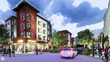
The premier project that started it all is the Market Center led by K2 Development Company in Partnership with the City of Redding, Shasta Regional Transportation Agency, and the State of California Housing and Community Development Agency. This $44 Million project razed the former Dicker's Building in the old Downtown Mall to make way for a mixed-use building with 82 apartments above 22,000 SF of restaurant and retail space. In addition, the Market Street Promenade was removed to bring Market St back down through the heart of Downtown Redding and Yuba and Butte Streets returning to traffic in the core of Redding.
Following the success of K2 in the initiation of their Market Center Project came the Block 7 Project in partnership with The McConnell Foundation.
BLOCK 7 DOWNTOWN ACTIVATION PROJECT
· Developing a multi-site, mixed-use project on 1.75 acres in the central business district of downtown Redding, CA.
· 79 affordable housing units, 20 market rate housing units, small business retail opportunity spaces, complete streets, a pedestrian-activated alley, 20,000 SF of open space with urban greening, 20K Northern Midrise anchored by public institution, 2+ miles of context-sensitive bikeways, supporting parking.
· Total Project SF +/- 200,000[23]
Shasta County Courthouse
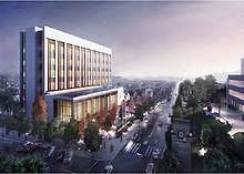
"The design and construction of the new Redding courthouse building consists of six stories above ground and a basement level with 14 courtrooms for a total of 166,887 building gross square feet (BGSF) in the city of Redding, County of Shasta. The new courthouse will be built on a 1.94-acre site in downtown Redding across from the existing main courthouse. The project includes 20 secure parking spaces for the court staff and six secure parking spaces for the marshals adjacent to the sallyport in the basement level. The project will utilize a Construction Manager at Risk delivery method. This facility will replace one courthouse and annex and three court facilities in Redding, provide space for a new judgeship from Assembly Bill (AB) 159 (Ch. 722, Statutes of 2007), and provide a new judgeship from the third group of 50.[24]
Government

State and federal representation
In the California State Legislature, Redding is in the 1st Senate District, represented by Republican Brian Dahle,[25] and the 1st Assembly District, represented by Republican Megan Dahle.[26]
In the United States House of Representatives, Redding is in California's 1st congressional district, represented by Republican Doug LaMalfa.[27]
Parks and recreation
Museums and public art
- Calatrava Sculpture
- Sculpture park at City Hall
- Sundial Bridge at Turtle Bay
- Shasta Historical Society

Architecture
- Carnegie Library
- Cascade Theatre
- Hotel Lorenz
- Pilgrim Congregational Church
- Sundial Bridge
Venues
- Cascade Theatre
- Riverfront Amphitheater
- Old City Hall
- Redding Civic Auditorium[31]
Performing arts
- Riverfront Playhouse
Education
Higher education
Public
High schools
Public
- Shasta High School
- Enterprise High School
- Foothill High School
- Pioneer High School
- University prep school
Secondary
- Freedom High School
- University Preparatory School
- North State Independence High School
- Redding Christian High School
- Liberty Christian High School
Charter schools
- Monarch Learning Center
- Stellar Charter School
- Phoenix Charter Academy
- Redding Collegiate Academy
- Redding School of the Arts
- Rocky Point Charter School
- Shasta Charter Academy
Other schools
- Bethel Christian School
- Mt. Calvary Lutheran School
- Redding Adventist Academy
Trade schools
- Redding Institute of Technology
- Shasta School of Cosmetology
Media
Print
Broadcast
Television
| Channel | Call sign | Network |
|---|---|---|
| 7.1 | KRCR-DT | ABC |
| 7.2 | -- | MeTV |
| 7.3 | -- | Movies! |
| 9.1 | KIXE-DT | PBS |
| 9.2 | KIXE-DT2 | Create |
| 9.3 | KIXE-DT3 | PBS World |
| 12.1 | KHSL-DT | CBS |
| 12.2 | KHSL-DT2 | The CW |
| 17.1 | KXVU-LD | Telemundo |
| 20.1 | KCVU-DT | Fox |
| 20.2 | KCVU-DT2 | ThisTV |
| 21.1 | KRVU-LD | MyNetworkTV |
| 23.1 | KRDT-LD | Religious |
| 23.2 | KRDT-LD2 | HSN |
| 24.1 | KNVN-DT | NBC |
| 24.2 | -- | Telemundo |
| 26 | KGEC-LD | Religious |
| 27.1 | KUCO-LD | Univision |
| 33 | K33HH | 3ABN |
| 35.1 | KKTF-LD | Telefutura |
| 41.1 | KRHT-LD | Azteca America |
Radio
AM radio
| Call letters | kHz | Format |
|---|---|---|
| KVIP | 540 | Religious[32] |
| KLXR | 1230 | Nostalgia[32] |
| KQMS | 1400 | News/Talk[33] |
| KCNR | 1460 | Talk[32] |
| KNRO | 1670 | Sports[32] |
FM radio
| Call letters | MHz | Format |
|---|---|---|
| KNNN-LP | 87.7 | Indie & Alternative Rock |
| KKRN | 88.5 | Community Radio[32] |
| KFPR | 88.9 | Public Radio[32] |
| K211CO (KHRI translator) | 90.1 | Air 1 Christian Contemporary[32] |
| K227AE (KHRD translator) | 93.3 | Classic Rock[32] |
| KEWB | 94.7 | Top 40[32] |
| KALF | 95.7 | Hot Country |
| KNCQ | 97.3 | Country[32] |
| K249EW (KAWZ translator) | 97.7 | Religious[32] |
| KVIP | 98.1 | Christian Talk Radio |
| KWLZ | 99.3 | Rhythmic Contemporary[32] |
| KWCA | 101.1 | Hot AC/Mix (licensed to suburb Palo Cedro)[34] |
| K268AJ (KHAP translator) | 101.5 | Religious[32] |
| KKRO | 102.7 | Air 1 Christian Contemporary |
| KSHA | 104.3 | Adult Contemporary[32] |
| KRDG | 105.3 | Classic Hits[32] |
| KRRX | 106.1 | Rock[32] |
| K298AF (KAWZ translator) | 107.5 | Religious (licensed to nearby Shasta)[32] |
| KKLC | 107.9 | K-LOVE Christian Contemporary[32] |
Transportation
Major highways
.svg.png)

.svg.png)


.svg.png)
Rail and bus transportation
Amtrak, the national passenger rail system, provides service to Redding station, operating its Coast Starlight daily in both directions between Seattle, Washington, and Los Angeles, California VA Portland, Oregon; Sacramento, California; Oakland, California; San Jose, California; Santa Barbara, California and all Intermediate station stops. Amtrak California also provides Thruway Motorcoach service to Stockton or Sacramento for connections to the San Joaquins, which serve the San Francisco Bay Area, San Joaquin Valley and the Los Angeles area via bus connections.
Redding provides a city bus transportation system called RABA (Redding Area Bus Authority). RABA provides routes throughout the city of Redding and also provides transportation throughout Redding's suburbs. Transportation is also available by Sage Stage to Alturas and Trinity Transit to Weaverville.[35] Redding is also served by the intercity bus companies Greyhound and Fronteras del Norte.[36]
Air transportation
Air transportation for the Redding area is provided by two general aviation airports. Redding Municipal Airport, located south of Redding, has scheduled flights from SkyWest (United Express). The smaller Benton Airpark is located on the western side of Redding.
Prominent persons
This list includes notable persons who were born/raised/worked in, lived in, or whose identity was significantly influenced by Redding, as well as music groups that were founded in the area.
Actors and entertainment industry
- Ashley Parker Angel – recording artist and actor
- David de Berry – theater composer and actor
- Shane Drake – music video director
- Francesca Eastwood – actor
- Rich Eisen – sportscaster
- Kathleen Kennedy – film producer
Authors
- Bill Johnson – author and pastor
- Matthew Kennedy – author
- Tom Meyer (Bible Memory Man) – professor, speaker, and author
Business leaders and entrepreneurs
- Kevin Rose – Internet entrepreneur
Musicians and bands
- Cory Asbury – Contemporary Christian singer
- Duffy Bishop – electric blues singer and songwriter
- Randy Miller – drummer of the Myriad
- Craig Padilla – ambient electronic musician and film score composer
- Roy Rogers – guitarist
Athletes
- Rick Bosetti – professional baseball player
- Greg Cadaret – MLB player
- Mel Hein – football player, 1938 MVP, NFL Hall of Fame inductee
- Eddie Machen – heavyweight boxer
- Buck Martinez – professional MLB player, manager, broadcaster
- Matt Nichols – player in Canadian Football League
- Ryan O'Callaghan – NFL football player
- Bill Plummer – MLB player, coach and manager
- Megan Rapinoe – professional soccer player, Olympic gold medalist
- Ricky Ray – football player in the Canadian Football League
- Lynne Roberts – college basketball coach
- D. J. Seeley – basketball player in Israeli Premier League and Euroleague
- Jason Sehorn – former NFL player
Politicians, civil servants and activists
- Raymond Jacobs – US Marine, said to be in photo of first flag raised on Iwo Jima
- Brian Sandoval – 29th governor of Nevada
Other people
- Sam Butcher – Artist, Precious Moments
- Jeffery Dangl – plant immunologist
- Ruggles brothers – stagecoach robbers
See also
- 2018 Shasta County Wildfires: Carr Fire, Hirz Fire, Delta Fire
References
- "Redding, CA Real Estate and Living". Reddingshomebuyers.com. Retrieved July 27, 2018.
- "2016 U.S. Gazetteer Files". United States Census Bureau. Retrieved June 28, 2017.
- "Redding". Geographic Names Information System. United States Geological Survey. Retrieved November 22, 2014.
- "Population and Housing Unit Estimates". Retrieved May 21, 2020.
- "2010 Census Interactive Population Search: CA – Redding city". U.S. Census Bureau. Archived from the original on July 15, 2014. Retrieved July 12, 2014.
- "Redding (city) QuickFacts". United States Census Bureau. Archived from the original on January 1, 2012. Retrieved May 23, 2015.
- "How Redding got its Name". Retrieved August 25, 2017.
- Papers On Wintu Ethnography : 239 Wintu Villages In Shasta County Circa 1850. Redding, CA: Redding Museum and Art Center. 1980.
- "California Cities by Incorporation Date". California Association of Local Agency Formation Commissions. Archived from the original (Word) on November 3, 2014. Retrieved August 25, 2014.
- "Historic Redding California". Retrieved August 27, 2017.
- "City of Redding Flag". Retrieved August 19, 2017.
- "Carr Fire Incident Update 7/29/18 PM" (PDF). Retrieved July 30, 2018.
- "'Terrifying' tornadoes of flame leave 2 dead as inferno destroys Californian city of Redding". The Daily Telegraph. London. July 28, 2018. Retrieved July 28, 2018.
- "US Gazetteer files: 2010, 2000, and 1990". United States Census Bureau. February 12, 2011. Retrieved April 23, 2011.
- Environmental Impact Report for the Redding Redevelopment Plan, Earth Metrics, City of Redding and California State Clearinghouse Report (1990)
- "Web Soil Survey". Websoilsurvey.nrcs.usda.gov. Retrieved February 28, 2016.
- "NOAA". noaa.gov. Retrieved November 19, 2017.
- "Redding, CA Climate". Western Regional Climate Center. Retrieved June 20, 2011.
- "NOWData – NOAA Online Weather Data". W2.weather.gov. Retrieved August 28, 2017.
- "Census of Population and Housing". Census.gov. Retrieved June 4, 2015.
- Jun 11, Shasta EDC |; News, 2019 | Local (June 11, 2019). "PRESS RELEASE: REDDING MSA RECOGNIZED ONCE AGAIN". Shasta EDC. Retrieved April 27, 2020.
- "Comprehensive Annual Financial Report". cityofredding.org. Retrieved December 16, 2017.
- "Project Portfoilo". K2 Development Companies. Retrieved April 27, 2020.
- "Shasta County, New Redding Courthouse - facilities_program". www.courts.ca.gov. Retrieved April 27, 2020.
- "Senators". State of California. Retrieved March 10, 2013.
- "Members Assembly". State of California. Retrieved March 2, 2013.
- "California's 1st Congressional District - Representatives & District Map". Civic Impulse, LLC. Retrieved March 1, 2013.
- "City Council Information | City of Redding". www.cityofredding.org. Retrieved February 21, 2020.
- "City Council Information". City of Redding. Archived from the original on December 6, 2015. Retrieved November 12, 2016.
- "Redding's City Manager". City of Redding. Archived from the original on February 20, 2015. Retrieved March 7, 2015.
- https://www.reddingcivic.com/
- "Radio Stations in Redding, California". Radio-locator.com. Retrieved February 28, 2016.
- United States. Congress (1969). Congressional Record: Proceedings and Debates of the ... Congress. U.S. Government Printing Office. Retrieved July 22, 2013.
- "Radio Stations in Redding, California". Radio-locator.com. Retrieved February 28, 2016.
- "Modoc County, California : Redding". Sagestage.com. January 30, 2014. Retrieved February 28, 2016.
- "AIBRA – Find a Station". Kfhgroup.com. Retrieved May 2, 2015.
External links
| Wikimedia Commons has media related to Redding, California. |
| Wikivoyage has a travel guide for Redding, California. |
- Official website
- Images of Redding from the Eastman's Originals Collection, Special Collections Dept., University of California, Davis.
- "Redding, California". C-SPAN Cities Tour. May 2017.
Geographic location
Places adjacent to Redding, California | ||||||||||
|---|---|---|---|---|---|---|---|---|---|---|
| ||||||||||
| Mountains |  | |
|---|---|---|
| Bodies of Water | ||
| Rivers | ||
| Incorporated Cities | ||
| Counties | ||
| Parks |
| |
Municipalities and communities of Shasta County, California, United States | ||
|---|---|---|
| Cities |  Shasta County map | |
| CDPs | ||
| Unincorporated communities | ||
| Indian reservations | ||
| Ghost towns |
| |
| Footnotes | ‡This populated place also has portions in an adjacent county or counties | |
| Authority control |
|
|---|