Singleton, New South Wales
Singleton is a town on the banks of the Hunter River in New South Wales, Australia. Singleton is 144 km (89 mi) north-north-west of Sydney, and 70 km (43 mi) northwest of Newcastle.[2][3] At June 2018, Singleton had an urban population of 16,346.[1]
| Singleton New South Wales | |||||||||
|---|---|---|---|---|---|---|---|---|---|
Singleton | |||||||||
| Coordinates | 32°34′0″S 151°10′11″E | ||||||||
| Population | 16,346 (2018)[1] | ||||||||
| Postcode(s) | 2330 | ||||||||
| Elevation | 40 m (131 ft) | ||||||||
| Location |
| ||||||||
| LGA(s) | Singleton Shire Council | ||||||||
| County | Northumberland | ||||||||
| State electorate(s) | Upper Hunter | ||||||||
| Federal Division(s) | Hunter | ||||||||
| |||||||||
Singleton's main urban area includes the town centre, Singleton Heights, Dunolly, Darlington, The Retreat, Wattle Ponds and Hunterview. Surrounding rural villages include Broke, Camberwell, Jerrys Plains, Goorangoola/Greenlands, Belford and Lower Belford.
Singleton is located on the north-eastern part of the geological structure known as the Sydney basin, which borders the New England region.[4]
History
Singleton was established in the 1820s. In its early years, it was also called Patrick's Plains.[5] The Main Northern railway line reached Singleton in 1863 and was the end of the line until 1869. The town retains many historic buildings, including the original court house built in 1841, various large churches and many traditional Australian pubs. The countryside surrounding Singleton contains an unusual number of fine old mansions, reflecting the aristocratic nature of land grants when the area was settled. They include 'Neotsfield' (1828), the elaborate 'Baroona' (1829), 'Abbey Green' (1865) and stunning 'Minimbah' (1877).
Singleton was subject to the major flooding of the Hunter River in 1955, causing extensive damage to the town. When the area was being settled, the government originally attempted to create a town at Whittingham in a flood-free area, but the town grew by the river nonetheless. An embankment was constructed following the 1955 floods to help protect the town against any future flooding.
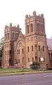
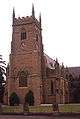 All Saints' Anglican Church
 All Saints' Church Rectory
Population
According to the 2016 census of Population, there were 16,089 people in the Singleton urban area.
- Aboriginal and Torres Strait Islander people made up 6.2% of the population.
- 85.1% of people were born in Australia. The next most common countries of birth were New Zealand 2.2%, England 1.5%, Philippines 0.8% and South Africa 0.7%.
- 90.6% of people spoke only English at home. No Re
- The most common responses for religion were Anglican 29.0%, Catholic 25.0% and No Religion 23.1%.[6]
Climate
Singleton has a humid subtropical climate (Köppen climate classification: Cfa) with hot wet summers and cool drier winters.
| Climate data for Singleton | |||||||||||||
|---|---|---|---|---|---|---|---|---|---|---|---|---|---|
| Month | Jan | Feb | Mar | Apr | May | Jun | Jul | Aug | Sep | Oct | Nov | Dec | Year |
| Record high °C (°F) | 44.4 (111.9) |
40.0 (104.0) |
41.0 (105.8) |
34.7 (94.5) |
28.2 (82.8) |
25.4 (77.7) |
26.0 (78.8) |
30.4 (86.7) |
33.0 (91.4) |
39.0 (102.2) |
43.0 (109.4) |
41.4 (106.5) |
44.4 (111.9) |
| Average high °C (°F) | 30.6 (87.1) |
29.6 (85.3) |
27.7 (81.9) |
25.4 (77.7) |
21.1 (70.0) |
18.3 (64.9) |
18.0 (64.4) |
20.1 (68.2) |
23.1 (73.6) |
26.0 (78.8) |
27.6 (81.7) |
29.7 (85.5) |
24.8 (76.6) |
| Average low °C (°F) | 17.3 (63.1) |
17.2 (63.0) |
15.2 (59.4) |
11.1 (52.0) |
8.6 (47.5) |
5.6 (42.1) |
4.8 (40.6) |
5.0 (41.0) |
8.0 (46.4) |
10.7 (51.3) |
13.5 (56.3) |
15.9 (60.6) |
11.1 (52.0) |
| Record low °C (°F) | 9.6 (49.3) |
9.6 (49.3) |
7.5 (45.5) |
2.5 (36.5) |
0.4 (32.7) |
−2.0 (28.4) |
−3.9 (25.0) |
−4.2 (24.4) |
0.4 (32.7) |
2.5 (36.5) |
5.0 (41.0) |
8.1 (46.6) |
−4.2 (24.4) |
| Average precipitation mm (inches) | 70.2 (2.76) |
107.6 (4.24) |
75.1 (2.96) |
38.3 (1.51) |
37.8 (1.49) |
31.7 (1.25) |
41.7 (1.64) |
27.6 (1.09) |
44.1 (1.74) |
32.8 (1.29) |
59.2 (2.33) |
86.6 (3.41) |
649.4 (25.57) |
| Average precipitation days | 10.1 | 10.1 | 9.1 | 7.1 | 8.1 | 8.4 | 7.1 | 6.8 | 8.3 | 6.6 | 10.5 | 9.9 | 102.1 |
| Average relative humidity (%) | 49 | 52 | 54 | 51 | 60 | 57 | 54 | 44 | 43 | 43 | 46 | 47 | 50 |
| Source: [7] | |||||||||||||
Transport
The town is located at the junction of the New England Highway and Putty Road. The Golden Highway branches northwest from the New England Highway ten kilometres south of Singleton. Singleton is also served by local and long-distance rail services. Singleton railway station on the Main Northern railway line is located at the southern end of the town centre. There are also bus services, both intercity and local. A bypass for the New England Highway is planned to divert traffic from Singleton, more than 26,000 vehicles travel through Singleton daily, the environmental assessment and concept design are open to public feedback in 2019.
Economy
Major industries near Singleton include coal mining, electricity generation, light industry, vineyards, horse breeding and cattle production. Dairying was once a mainstay in the area, but has declined.
The largest employment industry is coal mining, which employs 24 percent of the town's workforce.[8] Defence is the second largest employer with almost 4 percent of the workforce.[8]
The Lone Pine army barracks is located 8 kilometres (5.0 mi) south of Singleton.
Media
Print
The Singleton Argus is a bi-weekly newspaper which was established in 1874. It is currently owned and published by Fairfax Media. The weekly newspaper that serves Singleton and the Hunter Valley is The Hunter Valley News,[9] which, along with the Newcastle Herald newspaper (daily, except Sundays), is published by Fairfax Media.
Radio
Radio Stations serving both Newcastle and the Hunter Valley can be received in Singleton.
Television
Singleton is part of the Newcastle-Hunter Region television market, which is served by 5 television networks, three commercial and two national services (which include new sub-channels that started in 2009 for the commercial networks and in recent years from the national services).
Tourism
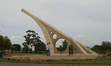
- Sundial. Singleton is home to one of the world's largest sundials, presented by a local coal mine for the 1988 Bicentennial Celebrations.
- Wineries. The town is close to the famous Pokolbin wine region (southeast). There are also many wineries in the shire, especially around Broke.
- Boating. Lake St Clair is an artificial lake located to the north of the town, with facilities for boating and camping.
- National Parks. Wollemi and Yengo National Parks are located south of the town via the Putty Road. Barrington Tops National Park borders the north of the shire.
- Museums. Singleton has three main museums, the Singleton Historic Society Museum in Burdekin Park, the Royal Australian Infantry Corps Museum at the nearby barracks and the Mercy Convent Museum 'Sacred Spaces' within the grounds of the Convent of the Sisters of Mercy (Singleton).
 St Patrick's Catholic Church, Queen Street
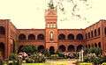 Convent of the Sisters of Mercy
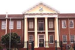
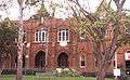 St Catherine's College
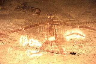 Aboriginal painting, Baiame Cave, Milbrodale
Heritage listings
Singleton has a number of heritage-listed sites, including:
- 25 Dangar Road: Singleton District Hospital[10]
- 25-27 George Street: Singleton Post Office[11]
- 88 George Street: Ewbank[12]
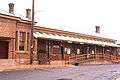
- Main Northern railway: Singleton railway station[13]
- Queen Street: St Patrick's Roman Catholic Church Cemetery[14]
Education
Singleton is home to a number of educational facilities. These include schools operated by NSW Department of Education and two non-government schools at both Primary and Secondary levels; as well as a TAFE campus, Singleton Community College and a number of pre-schools. St Catherine's Catholic College provides classes from kindergarten to year 12, while Australian Christian College has classes from pre-kindergarten to year 10.
Schools operated by NSW Department of Education include:
- Broke Public School
- Jerrys Plains Public School
- King Street Public School
- Milbrodale Public School
- Kirkton Public School
- Mount Pleasant Public School
- Singleton Heights Public School
- Singleton Public School
- Singleton High School
Hunter Institute of TAFE operates a campus in Singleton. It provides training and further education as well as collaborating with secondary schools for students completing Senior years.
Notable people
- Joseph Burnett – born in Singleton in 1899 and is best known as the Captain of the ill-fated HMAS Sydney, which was lost on 19 November 1941 in a battle with German auxiliary cruiser Kormoran
- Charles Dutton – a Queensland politician, was born in Singleton
- Dale Frank – an artist, was born and currently lives in Singleton
- Kerrod Holland – a rugby league player
- Joy McKean – an Australian country music matriarch, was born in Singleton in 1930
- Cherie Nowlan – a television and film producer, was born in Singleton, best known for directing the 1997 film Thank God He Met Lizzie
- Toby Price – the 2016 Dakar Rally champion lives in Singleton
- Wendy Richardson OAM – a playwright, was born in Singleton in 1933
- Sean Rudder – a rugby league player
- Josh Valentine – a rugby union player
- Sir Charles Wade – a former Premier of New South Wales, serving from 1907-1910, was born in Singleton
Sister city
![]()
See also
- List of world's largest roadside attractions
References
- "3218.0 – Regional Population Growth, Australia, 2017-18: Population Estimates by Significant Urban Area, 2008 to 2018". Australian Bureau of Statistics. Australian Bureau of Statistics. 27 March 2019. Retrieved 25 October 2019. Estimated resident population, 30 June 2018.
- Robinson's Road Atlas of Australia, Lansdowne Press, 1983
- "Distance from Singleton, Australia to other cities - Distance Calculator". www.geodatos.net. Retrieved 18 December 2019.
- http://www.dpi.nsw.gov.au/__data/assets/image/0007/96847/20758.gif
- Gee, Valma. "Patrick's Plains". Family History society of Singleton. Retrieved 24 January 2010.
- Australian Bureau of Statistics (27 June 2017). "Singleton (Significant Urban Area)". 2016 Census QuickStats. Retrieved 23 December 2019.


- "Climate statistics for Singleton". Bureau of Meteorology. Retrieved 1 July 2011.
- Australian Bureau of Statistics (31 October 2012). "Singleton (SUA)". 2011 Census QuickStats. Retrieved 17 November 2016.
- "Hunter Valley News". huntervalleynews.net.au. Retrieved 11 November 2012.
- "Singleton District Hospital". New South Wales State Heritage Register. Office of Environment and Heritage. H00833. Retrieved 18 May 2018.
- "Post Office (former)". New South Wales State Heritage Register. Office of Environment and Heritage. H00478. Retrieved 18 May 2018.
- "Ewbank & Outbuildings". New South Wales State Heritage Register. Office of Environment and Heritage. H00174. Retrieved 18 May 2018.
- "Singleton Railway Station group". New South Wales State Heritage Register. Office of Environment and Heritage. H01246. Retrieved 18 May 2018.
- "St. Patrick's Roman Catholic Church Cemetery". New South Wales State Heritage Register. Office of Environment and Heritage. H00233. Retrieved 18 May 2018.
- "International Exchange". List of Affiliation Partners within Prefectures. Council of Local Authorities for International Relations (CLAIR). Archived from the original on 22 December 2015. Retrieved 21 November 2015.
External links
| Wikimedia Commons has media related to Singleton, New South Wales. |
| Wikivoyage has a travel guide for Singleton. |
- "Hunter River catchment" (map). Office of Environment and Heritage. Government of New South Wales.
- Singleton Shire Council
- Tourist guide for Singleton - Visit NSW
| Authority control |
|
|---|