Puerto Rico Highway 53
Puerto Rico Highway 53 or PR-53 (unsigned Interstate PR3) is a main tollway that is parallel to Puerto Rico Highway 3, which goes from Fajardo to Salinas.[5] Some segments are still in planning, but when finished it will have about 58 miles (93 km) of length. Two tunnels, about 0.6 mi (1 km) long each, in the towns of Yabucoa and Maunabo were completed in October 2008. It will connect the cities of Fajardo, Ceiba, Naguabo, Humacao, Yabucoa, Maunabo, Patillas, Arroyo, Guayama and Salinas, thus bordering the entire eastern and southeastern coasts of Puerto Rico. Its northern terminus is at PR-3 and PR-194 in Fajardo, and its south terminus is at PR-52 in Salinas.
| ||||
|---|---|---|---|---|
| Autopista Dr. José Celso Barbosa | ||||
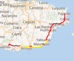
PR-53 highlighted in red; future segments in yellow | ||||
| Route information | ||||
| Maintained by Puerto Rico DTPW | ||||
| Length | 94.0 km[1][2][3][4] (58.4 mi) | |||
| History | 1994 and Extended To Yabucoa in 2002 (Completion in 2017) | |||
| Major junctions | ||||
| South end | ||||
| North end | ||||
| Location | ||||
| Municipalities | Salinas, Guayama, Arroyo, Patillas, Maunabo, Yabucoa, Humacao, Naguabo, Ceiba, Fajardo | |||
| Highway system | ||||
| ||||


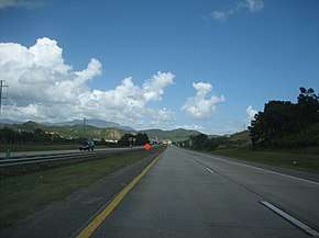
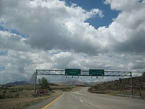
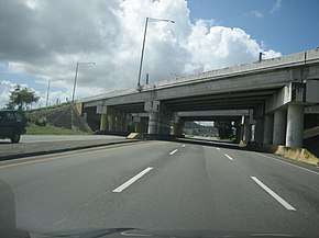
Route description
The highway consists of five toll plazas; these are at Ceiba Norte, Humacao Norte, Humacao Sur[6] (near Palmas del Mar), Guayama and Salinas.
All toll plazas have the Auto Expreso lanes.
Three phases of the tollway have been completed: the first one was from Salinas to Guayama, which is about 7.5 miles (12.1 km) long (milepost 83 to 95 km), the second from Fajardo to Yabucoa at 28 mi (45 km) (This includes an incomplete bridge in Yabucoa that does not fall into the high-speed highway classification in the interstate system as it is only one lane per direction and will require the addition of an additional bridge or constructing a bridge over the existing bridge, as it lies in a main corn and plantain field.) Recently 1.2 miles (1.9 km), between Yabucoa and Maunabo, includes the last tunnel, Vicente Morales, was opened in October 2008. The total constructed highway at this time is 34 miles (55 km), leaving nearly 25 miles (40 km) to be constructed in Yabucoa (including the other additional tunnel) and from Maunabo to Guayama which is the longest to-be-built segment. The lanes in the Yabucoa segments were divided by painted yellow lines and no-passing zone boards, but a concrete median barrier had to be installed because some cars still passed others going slower, resulting in deadly head-on collisions; illegal night races also had deadly consequences.
PR-53 is the tollway with the lowest traffic in Puerto Rico, and very few congestion jams have been reported. PR-53 does not enter highly populated towns (none of them are over 100,000; the largest are Fajardo, Humacao and Guayama) and is not close to increase its traffic due to the fact that most of the population in the east part of Puerto Rico live in the San Juan metro area, Caguas and Cayey, cities where PR-53 makes no appearance; and the main traffic in Humacao is mostly located on the PR-30 and PR-60 highways. The center/business area of Humacao is accessed via PR-30 and PR-60, not by PR-53. Because of this, PR-53 has no more than two lanes per direction in the constructed segments and will probably have no more than two lanes per direction in the entire length.

PR-53 is also prone to flooding in the areas near Naguabo and Fajardo: during heavy rains, it is sometimes closed to traffic. There are current proposals to convert PR-3 from Rio Grande to Fajardo into a freeway to provide a controlled-access route between PR-53's northern terminus and the second phase of PR-66. At the rate of construction, the entire PR-53 corridor might be completed within the next ten years. The first segment of PR-53 was opened in 1994. From Fajardo to Ceiba in 1994 And from Ceiba To Humacao In 1997 except between Exit 13 and 17 in Summer 2002
Exit list
| Municipality | Location | km [1][2][3][4] | mi | Exit | Destinations | Notes | |
|---|---|---|---|---|---|---|---|
| Salinas | Lapa | 94.0 | 58.4 | — | Southern terminus of PR-53; PR-52 exits 60 and 61 | ||
| 93.1 | 57.8 | Húcar Toll Plaza (toll northbound only) | |||||
| Aguirre | 90.8– 90.7 | 56.4– 56.4 | 90 | ||||
| Guayama | Pozo Hondo | 87.0– 86.9 | 54.1– 54.0 | 87 | |||
| 83.5 | 51.9 | 83 | |||||
| 82.1 | 51.0 | Guayama Toll Plaza | |||||
| Palmas | 80.8 | 50.2 | Western terminus of PR-54 | ||||
| Temporary gap in PR-53 | |||||||
| Arroyo | Palmas | 0.0[lower-alpha 1] | 0.0 | At-grade T junction | |||
| Patillas | Cacao Bajo | 1.0[lower-alpha 1] | 0.62 | At-grade T junction, closed | |||
| Pollos | 3.0[lower-alpha 1] | 1.9 | — | Incomplete Diamond interchange. Mainline stub exist for a future extension. | |||
| Temporary gap in PR-53 | |||||||
| Maunabo | Emajagua | 51.7 | 32.1 | At-grade T junction | |||
| 50.4– 49.8 | 31.3– 30.9 | Túnel Vicente Morales Lebrón | |||||
| 49.5 | 30.8 | At-grade T junction | |||||
| Temporary gap in PR-53 | |||||||
| Yabucoa | Camino Nuevo | 43.9 | 27.3 | Currently as At-grade Three-way junction. Diamond interchange and roundabout under construction for future extension.[7] | |||
| Río Guayanés and Río del Ingenio | 42.9– 40.3 | 26.7– 25.0 | Puente Ramón Luis Cruz Dávila | ||||
| Playa | 40.0 | 24.9 | 39 | South end of 4 lanes Interstate Highway standards to 2 lanes divided freeway. | |||
| Humacao | Candelero Abajo–Buena Vista line | 35.5 | 22.1 | 35 | Southbound exits signed 35A (north) and 35B (south) | ||
| Buena Vista | 34.8 | 21.6 | Humacao Sur Toll Plaza (toll southbound only) | ||||
| 33.8 | 21.0 | 33 | |||||
| Río Abajo | 31.2 | 19.4 | 31 | ||||
| Antón Ruíz | 28.3 | 17.6 | Humacao Norte Toll Plaza (toll northbound only) | ||||
| 25.9 | 16.1 | 25 | |||||
| Naguabo | Río Blanco | 22.2 | 13.8 | 22 | Southbound exit and northbound entrance | ||
| Maizales | 20.8– 20.7 | 12.9– 12.9 | 20 | ||||
| Duque | 18.3 | 11.4 | 18 | ||||
| Duque–Mariana line | 17.1 | 10.6 | 17 | Southbound exit only | |||
| Mariana | 13.6 | 8.5 | 13 | ||||
| Ceiba | Quebrada Seca | 10.3 | 6.4 | 10 | |||
| Ceiba barrio-pueblo | 5.9– 5.8 | 3.7– 3.6 | 6 | ||||
| Saco | 4.9 | 3.0 | 5 | ||||
| Machos | 4.1 | 2.5 | Ceiba Toll Plaza (toll southbound only) | ||||
| Fajardo | Quebrada Vueltas | 1.8 | 1.1 | 2 | Access to José Aponte de la Torre Airport | ||
| 0.0 | 0.0 | Northern terminus of PR-53. Interstate PR3 continues northwestbound via PR-3 as an At-grade traffic lighted expressway. | |||||
1.000 mi = 1.609 km; 1.000 km = 0.621 mi
| |||||||
- Kilometer markers in the Arroyo–Patillas segment have not been adjusted to those of the rest of PR-53.
Toll plazas
| Location | Toll | Direction | AutoExpreso acceptance |
AutoExpreso replenishment (R) lane |
|---|---|---|---|---|
| Húcar | $1.00 | Northbound | ||
| Guayama | $0.50 | Two-way | ||
| Humacao Sur | $1.00 | Southbound | ||
| Humacao Norte | $1.00 | Northbound | ||
| Ceiba | $1.00 | Southbound |
See also
- Interstate Highways in Puerto Rico
- List of highways in Puerto Rico
- List of highways numbered 53
References
- Google (28 February 2020). "PR-53 east" (Map). Google Maps. Google. Retrieved 28 February 2020.
- Google (28 February 2020). "PR-53 southeast" (Map). Google Maps. Google. Retrieved 28 February 2020.
- Google (28 February 2020). "PR-53 south" (Map). Google Maps. Google. Retrieved 28 February 2020.
- Google (28 February 2020). "PR-53 southwest" (Map). Google Maps. Google. Retrieved 28 February 2020.
- Puerto Rico Department of Transportation and Public Works. "Datos de Transito 2000-2009" (in Spanish). Retrieved 23 April 2019.
- "Humacao Bridges". National Bridge Inventory Data. US Dept. of Transportation. Retrieved 19 February 2019.
- https://www.google.com.pr/maps/@18.0461115,-65.8482502,707m/data=!3m1!1e3
External links
![]()
- Hawaii Highways: Puerto Rico – Puerto Rico Interstate Photographs (2002)
| Signed | |
|---|---|
| Unsigned | |
| Lists | |
| Other | |
Major Interstates highlighted | |