Landsborough Highway
Landsborough Highway is a highway in western Queensland, Australia, running in the northwest–southeast direction from Morven to Cloncurry.[1] The Landsborough Highway runs through vast tracts of land that was once occupied by William Landsborough, an Australian explorer of the 19th century. It is also the central part of the tourist route known as the Matilda Way after the popular Australian song Waltzing Matilda, which extends from Bourke in central northern New South Wales to Karumba on the Gulf of Carpentaria.[2]
Landsborough Highway | |
|---|---|
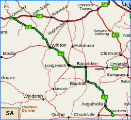 | |
Landsborough Highway (green on black) | |
| General information | |
| Type | Highway |
| Length | 1,049 km (652 mi) |
| Route number(s) | |
| Former route number | |
| Major junctions | |
| SE end | |
| |
| NW end | |
| Location(s) | |
| Major settlements | Augathella, Blackall, Barcaldine, Longreach, Winton |
| Highway system | |
The entire highway is an important part of the National Highway system linking Darwin and Brisbane: formerly National Route 66 (Cloncurry to Barcaldine) and National Route 71 (Barcaldine to Augathella), Queensland began to convert to the alphanumeric system much of Australia had adopted in the early-2000s and is now designated as National Route A2.[3] Its importance also stems from the fact that it is the only sealed link between Flinders Highway and Capricorn Highway apart from Gregory Development Road between Emerald and Charters Towers.
The highway services an important sheep and cattle grazing region, tourist traffic and local properties. The highway is fully sealed but with many sections of substandard width and quality. It is also flood-prone with lengthy closures during floods.
Towns
Towns along the highway are listed below:
Major intersections
| LGA | Location | km | mi | Destinations | Notes |
|---|---|---|---|---|---|
| Murweh | Morven | 0 | 0.0 | Southern end of Landsborough Highway (National Route A2) | |
| Augathella | 83.2 | 51.7 | |||
| Barcaldine | Barcaldine | 413.2 | 256.8 | ||
| Longreach | Longreach | 521.2 | 323.9 | Thomson Developmental Road is part of a former proposed National Route 79 from Melbourne to Longreach. This route is now signed as M79/A79 from Melbourne to Mildura, then B79 to Broken Hill, beyond which there is no signed number.[4] | |
| Winton | Winton | 699.2 | 434.5 | Eastern concurrency terminus with Kennedy Developmental Road | |
| Corfield | 705.1 | 438.1 | Western concurrency terminus with Kennedy Developmental Road | ||
| McKinlay | Kynuna | 859.1 | 533.8 | ||
| Cloncurry | Cloncurry | 1,033.1 | 641.9 | Eastern concurrency terminus with Flinders Highway | |
| 1,048.9 | 651.8 | Western concurrency terminus with Flinders Highway. Northern end of Landsborough Highway. | |||
1.000 mi = 1.609 km; 1.000 km = 0.621 mi
| |||||
References
- Queensland Government - Department of Transport and Main Roads - Maps
- "Queensland's Outback - Matilda Highway". outbackholidays.info. Archived from the original on 17 December 2009. Retrieved 30 September 2009.
- Hema, Maps (2007). Australia Road and 4WD Atlas (Map). Eight Mile Plains Queensland: Hema Maps. pp. 8–16/17. ISBN 978-1-86500-456-3.
- "National Route 79". ozroads.com.au. Retrieved 10 January 2017.