Peninsula Developmental Road
The Peninsula Developmental Road (PDR) runs 571 km from Lakeland to Weipa.[1] It is the main road transport link within Cape York Peninsula and to the rest of the Australian mainland.
Peninsula Developmental Road | |
|---|---|
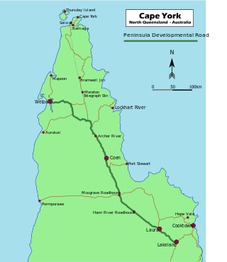 | |
Map of the Cape York Peninsula, with Peninsula Developmental Road highlighted in green | |
| General information | |
| Type | Rural road |
| Length | 571 km (355 mi) |
| Route number(s) | |
| Major junctions | |
| Southeast end | Lakeland |
| Bamaga Road (Telegraph Road) | |
| Northwest end | Weipa |
| Location(s) | |
| Major settlements | Coen |
The segment from Weipa Town to 43 km south of the town is within the Rio Tinto[2] mine lease. The 43 km within the Rio Tinto mine lease boundary is not part of the Queensland Department of Transport and Main Roads controlled road. The department excluded this 43 km section from its official PDR calculations.[3]
The segment from Lakeland to the Rio Tinto boundary is 466 km and is under Transport and Main Roads control.
Road conditions
320.5 km of 571 km from Lakeland to Weipa is currently unsealed road (as of March 2016).[4]
The condition of the unsealed road is highly variable. Mud, sand, dust, gravel and dirt corrugations are some of the road conditions subject to change of weather conditions.
A five-year program of sealing work joint funded by the Federal and State governments through the Cape York Region Package[5] commenced in 2014. As of December, 2015, 68.8 km of new road has been sealed through the Cape York Region Package.[6] As at June 2019, a total of 173km will be sealed under the package, leaving only 200km of 571km unsealed.
List of towns, localities and points of interest along the highway
Major intersections
| LGA | Location | km | mi | Destinations | Notes |
|---|---|---|---|---|---|
| Cook | Lakeland | 0 | 0.0 | South-eastern end of Peninsula Developmental Road (State Route 81) | |
| Weipa | Weipa | 571 | 355 | Hibberd Drive - north - Weipa Town Authority | North-western end of Peninsula Developmental Road |
| 1.000 mi = 1.609 km; 1.000 km = 0.621 mi | |||||
See also
References
- Hema Maps (2010). Cape York Regional Map (11 ed.). Eight Mile Plains, Qld: Hema Maps. ISBN 978-1-86500-227-9.
- "Weipa - Rio Tinto". riotinto.com. 27 November 2015. Retrieved 25 February 2016.
- Queensland Department of Transport and Main Roads (12 January 2016). "Cape York Region Package". tmr.qld.gov.au. Retrieved 25 February 2016.
- Queensland Department of Transport and Main Roads (12 January 2016). "Cape York Region Package". tmr.qld.gov.au. Retrieved 25 February 2016.
- Queensland Department of Transport and Main Roads (12 January 2016). "Cape York Region Package". tmr.qld.gov.au. Retrieved 25 February 2016.
- Queensland Department of Transport and Main Roads (12 January 2016). "Cape York Region Package". tmr.qld.gov.au. Retrieved 25 February 2016.