Climate of the Tampa Bay area
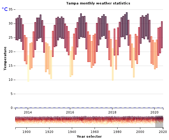
The Tampa Bay area has a humid subtropical climate closely bordering a tropical monsoon climate (Köppen Cfa) near the waterfront areas. There are two basic seasons in the Tampa Bay area, a hot and wet season from May through October, and a mild and dry season from November through April.
Nearly two-thirds of the annual precipitation falls in the months of June through September. The area is listed by the United States Department of Agriculture (USDA) as being in hardiness zone 9b as well as hardiness zone 10a just along the immediate coast and in peninsular Pinellas[1]; which is about the northern limit of where coconut palms and royal palms can be grown. Highs usually range between 65 and 95 °F (18 and 35 °C) year round. Tampa's official high has never reached 100 °F (38 °C) – the city's all-time record temperature is 99 °F (37 °C). St. Petersburg's all-time record high is exactly 100 °F (38 °C).[2]
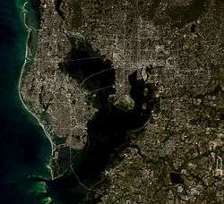
Pinellas County lies on a peninsula between Tampa Bay and the Gulf of Mexico, and much of the city of Tampa lies on a smaller peninsula jutting out into Tampa Bay. This proximity to large bodies of water both moderates temperatures and introduces large amounts of humidity into the atmosphere. In general, the local communities farthest from the coast have larger temperature ranges, both during a single day and throughout the seasons of the year.[3]
| Tampa | ||||||||||||||||||||||||||||||||||||||||||||||||||||||||||||
|---|---|---|---|---|---|---|---|---|---|---|---|---|---|---|---|---|---|---|---|---|---|---|---|---|---|---|---|---|---|---|---|---|---|---|---|---|---|---|---|---|---|---|---|---|---|---|---|---|---|---|---|---|---|---|---|---|---|---|---|---|
| Climate chart (explanation) | ||||||||||||||||||||||||||||||||||||||||||||||||||||||||||||
| ||||||||||||||||||||||||||||||||||||||||||||||||||||||||||||
| ||||||||||||||||||||||||||||||||||||||||||||||||||||||||||||
Seasonal weather
Wet Season

The hot and wet season begins in May and lasts through October. Seasonal high temperatures average about 90s °F (around 32 °C) and lows in the mid-70s °F (around 24 °C), accompanied by high humidity and an almost daily chance of thundershowers, especially in the afternoon. Day to day weather is remarkably consistent, with wet season average high and low temperatures usually only about five degrees above or below the record highs and lows.[4]
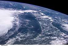
The typical summer weather pattern is for heat-produced thermals, powered by either the Gulf or Atlantic sea breeze (and occasionally both simultaneously), to build puffy white cumulus clouds into threatening thunderheads over the interior of the Florida peninsula. Usually, the resulting storms drift slowly westward to the bay area, though they may rain themselves out before reaching Tampa if the easterly winds are light or the sea breeze from the Gulf of Mexico is too strong. Stronger storm cells often survive to move out over the Gulf of Mexico, where they can be seen from the beaches as spectacular nighttime lightning shows.[3] Occasionally, storms form offshore overnight along the land-breeze front which is the dermal counterpart of the daytime sea-breeze front. If the prevailing winds are from the west or southwest, these storms can push ashore into the Tampa Bay area in the morning and move inland, reversing the more common pattern.
Summer thunderstorms typically bring brief periods of heavy rain and gusty winds with frequent cloud-to-ground lightning. Afternoon storms are usually followed by a pleasantly clear and cooler evening, while morning storms usually bring very high humidity levels and a chance for more rain in the afternoon. At times, these storms can grow severe, bringing damaging winds, small hail, and torrential rain, and an occasional tornado. While Florida does rank #1 in the US in terms of tornadoes per square mile, the majority of the twisters are small, weak, and short-lived.[5] Waterspouts are relatively common in Tampa Bay and off the gulf coast during strong summer thunderstorms, occasionally moving onshore as a short-lived tornado.
Though the Tampa Bay area is sometimes referred to as the "Lightning Capital of the World",[6] it is more accurately called the “Lightning Capital of North America” if measured by average number of days with thunderstorm activity per year. During the summer, west-central Florida receives as much lightning as the world's true lightning leaders such as the Lake Victoria region of Africa and the central Amazon River Basin. However, there are few thunderstorms in the Tampa Bay area from approximately October to May, decreasing the yearly average.[3]
Every year, Florida averages 10 deaths and 30 injuries from lightning strikes, with several of these usually occurring in or around Tampa.[7] University of Florida lightning expert Martin A. Uman has calculated that the average resident is within a half-mile of 10 to 15 lightning strikes every year.[8] TECO Energy, Tampa's electric utility, spends over millions of dollars annually to repair transformers and other equipment damaged by lightning strikes.[9]
Dry Season
The dry season often begins in early November and can last into early May. The local weather during these months is normally sunny, mild, and quite dry, with a general cooling trend through the fall and a slow increase in temperatures starting in February. Highs during the coolest part of the winter average around 70 °F (21 °C), usually with sunny skies. The occasional passage of a cold front will bring rain followed by a few days of cooler temperatures.[3] Lows rarely reach freezing 32 °F (0 °C), an occurrence which happens, on average, once every other year in areas away from the water and less frequently in areas on Tampa Bay or the Gulf of Mexico.[3] While deep freezes are very infrequent, serious cold snaps are a significant concern due to the diverse range of freeze-sensitive agriculture and aquaculture industries in the area as well as tropical landscaping such as coconut palms and royal palms.
Frozen precipitation is very rare in the Tampa Bay area. The only known measurable snowfall in Tampa after 1900 occurred on January 19, 1977. While the accumulation amounted to less than 0.5 inches (13 mm), the city is so unaccustomed to snow that public schools closed for the day and many businesses and roadways closed until it melted away that afternoon.[10] Many residents of southern Pinellas County reported a light snowfall on December 23, 1989. However, no snow fell at official weather stations, and the weather record indicates that light sleet fell on St. Petersburg that day.[11]
The winter of 2009–2010 was one of the coldest in local history. Both Tampa and St. Petersburg set records for consecutive days in which the high temperature did not reach 60 °F (16 °C), and Tampa experienced ten consecutive days with a low temperature below freezing.[12][13] Much of the area received a "wintry mix" of rain and sleet on January 9–10.[14]
According to The Weather Channel, Tampa's all-time record low temperature is 18 °F (−8 °C) and St. Petersburg's is 20 °F (−7 °C), both occurring during the same cold snap on December 13, 1962.[15]
During El Niño, the Tampa Bay area receives cooler and wetter conditions during the dry season while during La Niña, the Tampa Bay area becomes drier and warmer than normal.
Precipitation and sunshine trends
Due to the frequent summer thunderstorms, Tampa has a pronounced wet season, receiving an average total of 28 inches (710 mm) of rain from June and September but only about 18 inches (460 mm) during the remaining eight months of the year combined. The historical averages during the late summer, especially September, are augmented by tropical cyclones, which can easily deposit many inches of rain in one day. Outside of the summer rainy season, most of the area's precipitation is delivered by the occasional passage of a weather front.[9]
Tampa's precipitation data falls near the median for the area. Nearby communities to the interior tend to receive a bit more rain every year; those closer to the coast a bit less.[16]
The area receives plentiful sunshine throughout the year, averaging a total of 2920 hours, or 66.7% of the possible total.[17] The daily sunshine amount is highest in May, when the sun's angle of incidence has increased the hours of daylight and the rainy season has not yet begun.[17]
Tropical systems

June through November is hurricane season in the Atlantic Basin and Caribbean Sea, with the most tropical activity occurring between mid-August to mid-October.[18] Rain dropped by tropical systems is an important component of the area's annual precipitation and is vital for replenishing the water supply of communities around Tampa Bay.[19]
The area is threatened by tropical systems almost every year and feels some effect from passing storms several times per decade. However, due to Tampa Bay's location on the west coast and the typical steering winds for storms, landfall in the area is very uncommon, with estimates of the probability of a hurricane making landfall in the Tampa Bay area during any given year ranging from 1 in 25 to 1 in 50.[9][20] The small village of Tampa was devastated by the Great Gale of 1848, and the area suffered major damage during the Tampa Bay Hurricane of 1921. Since then, however, Tampa Bay has not seen the landfall of any hurricane. Manatee County, which is technically not part of the Tampa Bay area, in 1946 was the site of a Category 1 hurricane that lost hurricane strength immediately after landfall.[21][22][23]
On September 10, 2017, Hurricane Irma struck the Florida Keys and made landfall near Marco Island in southwest Florida as a Category 3 storm. Irma moved north up the length of the Florida peninsula and had weakened to a Category 1 storm by the time it neared central Florida. On the night of September 10 and 11, the eye passed east of Tampa through eastern Hillsborough County, bringing at least tropical storm winds to the entire Tampa Bay area. Irma caused significant damage to the region, particularly to the electrical grid.
The 2004 Tropical Season
The 2004 Atlantic Hurricane Season was historically busy for the Tampa Bay area. The region was affected by a record four hurricanes that year; Frances, Jeanne, Charley, and to a lesser extent, Ivan.[24] Jeanne and Frances passed over Tampa as tropical storms after making their way across the state from the east coast.[25][26] Charley was forecast to make a direct hit on Tampa Bay from the south-southwest, which would have been the worst-case scenario for local storm surge flooding.[27] But the storm made a sudden and unexpected turn to the northeast and brought only tropical storm force winds to the region, devastating the Ft. Myers/Port Charlotte area instead.[28][29] Ivan also threatened the area as it moved north up the eastern Gulf of Mexico. It remained far to the west of central Florida, however, and brought only a bit of rain and wind to Tampa Bay before eventually slamming into coastal Alabama and the Florida Panhandle.[30]
Tampa data
| Climate data for Tampa, Florida (Tampa Int'l), 1981−2010 normals,[lower-alpha 1] extremes 1890−present[lower-alpha 2] | |||||||||||||
|---|---|---|---|---|---|---|---|---|---|---|---|---|---|
| Month | Jan | Feb | Mar | Apr | May | Jun | Jul | Aug | Sep | Oct | Nov | Dec | Year |
| Record high °F (°C) | 86 (30) |
89 (32) |
92 (33) |
96 (36) |
98 (37) |
99 (37) |
98 (37) |
98 (37) |
96 (36) |
95 (35) |
92 (33) |
86 (30) |
99 (37) |
| Mean maximum °F (°C) | 81.1 (27.3) |
82.3 (27.9) |
85.2 (29.6) |
88.2 (31.2) |
93.3 (34.1) |
94.8 (34.9) |
94.8 (34.9) |
94.4 (34.7) |
93.5 (34.2) |
90.8 (32.7) |
86.2 (30.1) |
82.4 (28.0) |
96.0 (35.6) |
| Average high °F (°C) | 69.9 (21.1) |
72.5 (22.5) |
76.3 (24.6) |
81.0 (27.2) |
87.2 (30.7) |
89.6 (32.0) |
90.1 (32.3) |
90.2 (32.3) |
88.9 (31.6) |
84.3 (29.1) |
78.0 (25.6) |
72.0 (22.2) |
81.7 (27.6) |
| Average low °F (°C) | 51.6 (10.9) |
54.4 (12.4) |
58.2 (14.6) |
63.0 (17.2) |
69.7 (20.9) |
74.8 (23.8) |
75.9 (24.4) |
76.2 (24.6) |
74.5 (23.6) |
68.0 (20.0) |
60.3 (15.7) |
54.2 (12.3) |
65.1 (18.4) |
| Mean minimum °F (°C) | 32.6 (0.3) |
37.0 (2.8) |
41.4 (5.2) |
48.8 (9.3) |
59.6 (15.3) |
68.3 (20.2) |
70.8 (21.6) |
71.7 (22.1) |
67.5 (19.7) |
53.2 (11.8) |
44.6 (7.0) |
36.1 (2.3) |
30.2 (−1.0) |
| Record low °F (°C) | 21 (−6) |
22 (−6) |
29 (−2) |
38 (3) |
49 (9) |
53 (12) |
63 (17) |
66 (19) |
54 (12) |
40 (4) |
23 (−5) |
18 (−8) |
18 (−8) |
| Average rainfall inches (mm) | 2.23 (57) |
2.81 (71) |
3.03 (77) |
2.03 (52) |
2.10 (53) |
6.68 (170) |
7.07 (180) |
7.77 (197) |
6.30 (160) |
2.26 (57) |
1.55 (39) |
2.47 (63) |
46.30 (1,176) |
| Average rainy days (≥ 0.01 inch) | 6.8 | 6.6 | 6.6 | 4.9 | 5.5 | 12.7 | 15.9 | 16.0 | 12.2 | 6.5 | 5.1 | 5.8 | 104.6 |
| Average relative humidity (%) | 74.9 | 73.0 | 71.8 | 69.0 | 69.8 | 74.4 | 76.6 | 78.4 | 77.6 | 74.2 | 75.0 | 75.0 | 74.1 |
| Mean monthly sunshine hours | 199.9 | 202.7 | 267.5 | 299.1 | 314.5 | 277.8 | 265.3 | 249.5 | 223.0 | 233.9 | 201.7 | 191.6 | 2,926.5 |
| Percent possible sunshine | 61 | 65 | 72 | 78 | 75 | 67 | 62 | 61 | 60 | 66 | 62 | 60 | 66 |
| Source: NOAA (relative humidity and sun 1961−1990)[31][32][33] Weather Channel[34] | |||||||||||||
See or edit raw graph data.
See also
Notes
- Mean monthly maxima and minima (i.e. the highest and lowest temperature readings during an entire month or year) calculated based on data at said location from 1981 to 2010.
- Official records for Tampa were kept at downtown from April 1890 to December 1940, Peter O. Knight Airport from January 1941 to 5 June 1946, and at Tampa Int'l since 7 June 1946. For more information, see ThreadEx
References
- https://planthardiness.ars.usda.gov/phzmweb/interactivemap.aspx
- Tampa Weather Forecasts on Yahoo! Weather Archived December 16, 2008, at the Wayback Machine. Weather.yahoo.com. Retrieved on 2009-02-06.
- Winsberg, Morton (2003). Florida Weather. Gainesville: University Press of Florida. ISBN 978-0-8130-2684-8.
- "National Weather Service - Tampa climate data". National Oceanic and Atmospheric Administration (NOAA). Retrieved 2017-07-01.
- "Top Ten Tornado Lists". Tornadoproject.com. Archived from the original on 2012-02-04. Retrieved 2010-06-21.
- Jeff Klinkenberg (2008). Meet Thunderman. Archived 2012-03-15 at the Wayback Machine St. Petersburg Times. Retrieved on 2009-02-06.
- St. Petersburg Times (1999). Lightning capital of the nation. Archived 2011-04-12 at the Wayback Machine Retrieved on 2009-02-06.
- Lightning Research Laboratory (UF) Archived 2013-12-19 at the Wayback Machine. Lightning.ece.ufl.edu. Retrieved on 2009-02-06.
- Henry, James (1998). The Climate and Weather of Florida. Sarasota, Florida: Pineapple Press (FL). ISBN 978-1-56164-036-2.
- ShannonMulaire (2009-01-28). "Will it snow in Tampa?". Myfoxtampabay.com. Retrieved 2010-06-21.
- The Great Tampa Bay snow of '89. St. Petersburg Times. Retrieved on 2009-02-17.
- "Coldest winter in Tampa since 1969 ends Saturday". .tbo.com. 2010-03-19. Archived from the original on 2010-03-29. Retrieved 2010-06-21.
- "Record Breaking 10 Straight Days Below 60 Degrees WTSP.com 10 Connects". Wtsp.com. Archived from the original on 2013-02-09. Retrieved 2010-06-21.
- "Sleet falls in the Tampa Bay area". Archived from the original on 2013-10-04. Retrieved 2010-06-21.
- "Average Weather for Tampa, FL - Temperature and Precipitation". www.weather.com.
- "The Weather Channel (weather.com)". The Weather Channel Interactive, Inc. Retrieved 2006-11-25.
- Climatological Information for Almaty, Kazakhstan. Retrieved 16 August 2012.
- National Weather Service Office in Tampa Bay, Florida (2009). Tampa Bay Area Tropical Weather Page. National Weather Service Southern Region Headquarters. Retrieved on 2009-02-06.
- Craig Pittman (2009). Tampa Bay Water likely to overdraw from aquifer this spring. Archived 2012-03-15 at the Wayback Machine St. Petersburg Times. Retrieved on 2009-02-06.
- Bob Macpherson (2008). Experts brief citizens on hurricane preparedness. Tampa Bay Beach Beacon. Retrieved on 2009-02-17.
- Chris Landsea (2005). Subject: E24) How long has it been since a hurricane or a major hurricane hit a given community in the United States? Hurricane Research Division. Retrieved on 2009-02-06.
- McClure, Brian (May 21, 2010). "The Tampa Bay area has been lucky". Tampa Bay Times. Archived from the original on October 25, 2016. Retrieved October 24, 2016.
- Barnes, Jay (2012). Florida's Hurricane History. University of North Carolina Press. p. 169. ISBN 978-1-4696-0021-5.
- Jamie Thompson and Chase Squires (2004). 2004 Hurricane Season Ends. St. Petersburg Times. Retrieved on 2009-02-17.
- Miles B. Lawrence and Hugh D. Cobb (2005). Tropical Cyclone Report: Hurricane Jeanne 13–28 September 2004. National Hurricane Center. Retrieved on 2009-02-17.
- John L. Beven II (2004). Tropical Cyclone Report: Hurricane Frances 25 August – 8 September 2004. National Hurricane Center. Retrieved on 2009-02-17.
- Weather: Shrinking core reduced storm surge
- State: Countdown to landfall
- Richard J. Pasch, Daniel P. Brown, and Eric S. Blake (2005). Tropical Cyclone Report: Hurricane Charley 9–14 August 2004. National Hurricane Center. Retrieved on 2009-02-17.
- Stacey R. Stewart (2005). Tropical Cyclone Report: Hurricane Ivan 2–24 September 2004. Archived August 21, 2007, at the Wayback Machine National Hurricane Center. Retrieved on 2009-02-17.
- "NowData - NOAA Online Weather Data". National Oceanic and Atmospheric Administration. Retrieved 2018-10-02.
- "Station Name: FL TAMPA INTL AP". National Oceanic and Atmospheric Administration. Retrieved 2014-06-11.
- "WMO Climate Normals for TAMPA/INT'L ARPT FL 1961–1990". National Oceanic and Atmospheric Administration. Retrieved 2014-03-10.
- "Average Weather for Tampa, FL - Temperature and Precipitation". The Weather Channel. Retrieved 2011-10-03.