National Register of Historic Places listings in Mercer County, New Jersey
List of the National Register of Historic Places listings in Mercer County, New Jersey
| Atlantic - Bergen - Burlington - Camden - Cape May - Cumberland - Essex - Gloucester - Hudson - Hunterdon - Mercer - Middlesex - Monmouth - Morris - Ocean - Passaic - Salem - Somerset - Sussex - Union - Warren |
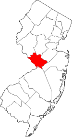
Location of Mercer County in New Jersey
This is intended to be a complete list of properties and districts listed on the National Register of Historic Places in Mercer County, New Jersey. The locations of National Register properties and districts (at least for all showing latitude and longitude coordinates below) may be seen in an online map by clicking on "Map of all coordinates".[1]
- This National Park Service list is complete through NPS recent listings posted June 19, 2020.[2]
Current listings
| [3] | Name on the Register[4] | Image | Date listed[5] | Location | City or town | Description |
|---|---|---|---|---|---|---|
| 1 | Abbott Farm Archeological Site |  Abbott Farm Archeological Site |
December 8, 1976 (#76001158) |
John A. Roebling Park, other nearby public and private lands 40°11′10″N 74°43′37″W |
Hamilton and Bordentown Townships, Bordentown[6] | Paleoindian settlement, 500 BC-500 AD.[7] Extends into Burlington County. |
| 2 | John Abbott II House |  John Abbott II House |
June 18, 1976 (#76001159) |
2200 Kuser Rd. 40°12′14″N 74°40′51″W |
Hamilton Township | Used to hide state treasury during American Revolution[8] |
| 3 | Abbott-Decou House |  Abbott-Decou House |
July 1, 1976 (#76001160) |
58 Soloff Dr. 40°11′08″N 74°43′11″W |
Hamilton Township | Fine example of 18th century Quaker Georgian architecture.[9] |
| 4 | Adams and Sickles Building |  Adams and Sickles Building |
January 31, 1980 (#80002498) |
1 W. End Ave. 40°13′36″N 74°46′45″W |
Trenton | Focal point for West End neighborhood, remembered for soda fountain and corner druggist.[10] |
| 5 | American Cigar Company Building |  American Cigar Company Building |
December 30, 2011 (#11000965) |
176 Division St. 40°12′45″N 74°44′41″W |
Trenton | Built in 1903 as part of Trenton's vibrant cigar industry |
| 6 | Anderson-Capner House |  Anderson-Capner House |
April 3, 1973 (#73001107) |
700 Trumbull Ave. 40°14′52″N 74°44′06″W |
Lawrence | Pre-revolutionary farmhouse built 1764[11] |
| 7 | Archeological Site No. 1-18th Century Vessel (28ME196) |  Archeological Site No. 1-18th Century Vessel (28ME196) |
August 14, 1986 (#86001508) |
Address Restricted |
Trenton | |
| 8 | Baker-Brearley House |  Baker-Brearley House |
August 31, 1979 (#79001499) |
East of Lawrenceville on Meadow Rd 40°17′33″N 74°42′03″W |
Lawrenceville | Georgian house built 1761[12] |
| 9 | Bear Tavern Road--Jacob's Creek Crossing Rural Historic District |  Bear Tavern Road--Jacob's Creek Crossing Rural Historic District |
November 30, 2011 (#11000872) |
Bear Tavern Rd. & Jacobs Creek Rd. 40°17′21″N 74°50′29″W |
Hopewell Township, Ewing Township | Colonial rural landscape, route of Continental Army in 1776[13] |
| 10 | Bellevue Avenue Colored School |  Bellevue Avenue Colored School |
January 2, 1997 (#96001547) |
81 Bellevue Ave. 40°13′32″N 74°46′17″W |
Trenton | |
| 11 | Berkeley Square Historic District |  Berkeley Square Historic District |
November 20, 1980 (#80002499) |
Roughly bounded by W. State St., Parkside, Riverside, and Overbrook Aves. 40°13′49″N 74°47′23″W |
Trenton | |
| 12 | Bow Hill |  Bow Hill |
January 25, 1973 (#73001111) |
477 Jeremiah Ave. off Lalor St. 40°11′32″N 74°44′39″W |
Hamilton Township | |
| 13 | Charles Brearley House |  Charles Brearley House |
April 14, 1995 (#95000407) |
73 N. Clinton Ave. 40°13′23″N 74°45′18″W |
Trenton | |
| 14 | Broad Street National Bank |  Broad Street National Bank |
January 17, 2008 (#07001404) |
143 E. State St. 40°13′12″N 74°45′43″W |
Trenton | |
| 15 | Camden and Amboy Railroad Right of Way Site |  Camden and Amboy Railroad Right of Way Site |
June 16, 2016 (#16000252) |
N. side of Rogers Ave. about 100 yds. W. of Mercer St. 40°16′09″N 74°31′31″W |
Hightstown | |
| 16 | Henry Clay and Bock & Co. Ltd. Cigar Factory |  Henry Clay and Bock & Co. Ltd. Cigar Factory |
June 12, 1979 (#79001500) |
507 Grand St. 40°12′11″N 74°44′45″W |
Trenton | Most architecturally distinctive industrial building in Trenton[14] |
| 17 | Grover Cleveland Home |  Grover Cleveland Home |
October 15, 1966 (#66000463) |
15 Hodge Road 40°21′05″N 74°40′04″W |
Princeton | Known as Westland Mansion |
| 18 | Crosswicks Creek Site III |  Crosswicks Creek Site III |
November 26, 1990 (#87001795) |
Address Restricted |
Bordentown | |
| 19 | Delaware and Raritan Canal |  Delaware and Raritan Canal |
May 11, 1973 (#73001105) |
Follows the Delaware River to Trenton, then E to New Brunswick 40°19′55″N 74°39′09″W |
Princeton | |
| 20 | Gen. Philemon Dickinson House |  Gen. Philemon Dickinson House |
May 17, 1974 (#74001172) |
46 Colonial Ave. 40°13′36″N 74°47′01″W |
Trenton | |
| 21 | Douglass House |  Douglass House |
December 18, 1970 (#70000387) |
Corner of Front and Montgomery Streets 40°13′08″N 74°45′42″W |
Trenton | George Washington's headquarters prior to the Battle of Princeton[15] |
| 22 | Drumthwacket | 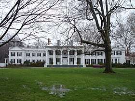 Drumthwacket |
June 10, 1975 (#75001142) |
344 Stockton Rd. 40°20′22″N 74°40′29″W |
Princeton | Official residence of the governor of New Jersey[16] |
| 23 | East Trenton Public Library |  East Trenton Public Library |
March 5, 2008 (#08000134) |
701 N. Clinton Ave. 40°14′00″N 74°44′30″W |
Trenton | |
| 24 | Albert Einstein House |  Albert Einstein House |
January 7, 1976 (#76002297) |
112 Mercer St. 40°20′40″N 74°39′59″W |
Princeton | |
| 25 | First Presbyterian Church |  First Presbyterian Church |
September 9, 2005 (#05000967) |
120 East State St. 40°13′14″N 74°45′48″W |
Trenton | |
| 26 | First Presbyterian Church of Pennington |  First Presbyterian Church of Pennington |
August 24, 2011 (#11000591) |
13 S. Main St. 40°19′39″N 74°47′25″W |
Pennington | |
| 27 | Golden Swan-True American | 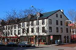 Golden Swan-True American |
April 30, 2008 (#08000361) |
101-107 S. Warren St. 40°13′09″N 74°45′58″W |
Trenton | |
| 28 | William Green House |  William Green House |
December 4, 1973 (#73001106) |
Metzger Drive 40°15′53″N 74°46′40″W |
Ewing Township | Historic farmhouse, dating to 1717. On Preservation New Jersey's list of 10 most endangered historic sites[17] |
| 29 | Green-Reading House |  Green-Reading House |
March 12, 1998 (#98000237) |
107 Wilburtha Rd. 40°15′38″N 74°49′32″W |
Ewing Township | Federal style farmhouse from ca. 1797[18] |
| 30 | Harbourton Historic District |  Harbourton Historic District |
December 31, 1974 (#74001167) |
Jct. of Harbourton/Rocktown Rd. and Harbourton/Mt. Airy Rd. 40°21′08″N 74°51′12″W |
Harbourton | |
| 31 | John D. Hart House |  John D. Hart House |
October 18, 1972 (#72000800) |
Curlis Ave. 40°19′18″N 74°46′59″W |
Pennington | Built ca. 1800, fine example of a clapboard house[19] |
| 32 | Hart-Hoch House |  Hart-Hoch House |
March 14, 1973 (#73001109) |
Southwest of Pennington on CR 546 and Scotch Rd. 40°18′34″N 74°48′43″W |
Hopewell Township | Federal style home, ca. 1800[20] |
| 33 | Joseph Henry House |  Joseph Henry House |
October 15, 1966 (#66000464) |
Princeton University campus 40°20′58″N 74°39′32″W |
Princeton | |
| 34 | Donald Grant Herring Estate |  Donald Grant Herring Estate |
January 17, 1992 (#91001927) |
52, 72 and 75 Arreton Rd., Princeton 40°22′56″N 74°39′57″W |
Princeton | |
| 35 | Higbee Street School | 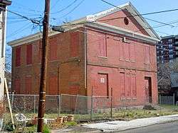 Higbee Street School |
April 14, 1995 (#95000409) |
20 Bellevue Ave. 40°14′04″N 74°45′57″W |
Trenton | |
| 36 | Highfields |  Highfields |
September 23, 1994 (#94001096) |
End of Lindbergh Rd., East Amwell Township 40°25′26″N 74°46′04″W |
Hopewell Township | Home of Charles and Anne Lindbergh. Site of the Lindbergh kidnapping.[21] Extends into Hunterdon County |
| 37 | Hog Island Cranes | 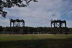 Hog Island Cranes |
June 17, 1980 (#80002500) |
Trenton Marine Terminal 40°11′27″N 74°45′22″W |
Trenton | |
| 38 | Hopewell Station |  Hopewell Station |
June 22, 1984 (#84002728) |
Railroad Pl. 40°23′29″N 74°45′48″W |
Hopewell | part of the Operating Passenger Railroad Stations Thematic Resource (TR) |
| 39 | House at 379 West State Street |  House at 379 West State Street |
January 23, 1980 (#80002501) |
379 W. State St. 40°13′29″N 74°46′41″W |
Trenton | Queen Anne revival house[22] |
| 40 | Hunt Farmstead |  Hunt Farmstead |
October 28, 1988 (#87002555) |
197 Blackwell Rd. 40°19′18″N 74°45′39″W |
Hopewell Township | |
| 41 | In and Out Social Club |  In and Out Social Club |
March 26, 1987 (#87000513) |
714-716 S. Clinton Ave. 40°12′34″N 74°45′06″W |
Trenton | Built in 1893 for "social, intellectual, and recreative purposes."[23] |
| 42 | Jugtown Historic District |  Jugtown Historic District |
January 22, 1987 (#86003670) |
Nassau and Harrison Sts., Harrison St. N, and Evelyn Pl. 40°21′14″N 74°38′49″W |
Princeton | |
| 43 | King's Highway Historic District | 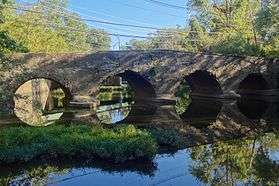 King's Highway Historic District |
December 21, 2000 (#00001493) |
NJ 27, US 206 40°20′54″N 74°39′52″W |
Lawrenceville, Princeton | Extends into Middlesex and Somerset Counties |
| 44 | Kingston Mill Historic District |  Kingston Mill Historic District |
April 10, 1986 (#86000707) |
Roughly bounded by Herrontown, River, Princeton-Kingston Rds., and lots west of Princeton 40°22′25″N 74°37′14″W |
Princeton | |
| 45 | Rudolph V. Kuser Estate |  Rudolph V. Kuser Estate |
August 24, 1979 (#79001501) |
315 W. State St. 40°13′23″N 74°46′36″W |
Trenton | |
| 46 | Lake Carnegie Historic District | Lake Carnegie Historic District |
June 28, 1990 (#90001000) |
Roughly bounded by Lake Carnegie shoreline from Conrail bridge at west end to dam west of Kingston at east end 40°20′51″N 74°38′12″W |
Princeton | |
| 47 | Lawrence Township Historic District |  Lawrence Township Historic District |
September 14, 1972 (#72000799) |
Lawrenceville and vicinity N, including both sides of U.S. 206 40°18′01″N 74°43′12″W |
Lawrenceville | |
| 48 | Lawrenceville School | .JPG) Lawrenceville School |
February 24, 1986 (#86000158) |
Main St. 40°17′45″N 74°43′49″W |
Lawrenceville | |
| 49 | Ichabod Leigh House |  Ichabod Leigh House |
March 4, 1975 (#75001139) |
Pennington-Rocky Hill Rd. 40°22′21″N 74°43′55″W |
Hopewell | |
| 50 | Thomas Maddock's Sons Company | 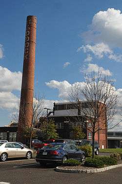 Thomas Maddock's Sons Company |
March 14, 2008 (#08000178) |
American Metro Boulevard 40°15′27″N 74°42′17″W |
Hamilton Township | Sanitary pottery manufacturing plant built 1924-25[24] |
| 51 | Mansion House |  Mansion House |
February 6, 1973 (#73001112) |
Cadwalader Park 40°14′12″N 74°47′22″W |
Trenton | |
| 52 | Maybury Hill | 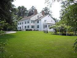 Maybury Hill |
November 11, 1971 (#71000502) |
346 Snowden Lane 40°22′02″N 74°38′34″W |
Princeton | |
| 53 | Mercer Street Friends Center | 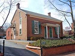 Mercer Street Friends Center |
August 12, 1971 (#71000505) |
151 Mercer St. 40°13′02″N 74°45′40″W |
Trenton | |
| 54 | Mill Hill Historic District |  Mill Hill Historic District |
December 12, 1977 (#77000880) |
Roughly bounded by Clay, Jackson, Front, Market, Broad, and Greenwood Sts. 40°13′01″N 74°45′40″W |
Trenton | |
| 55 | Morven | 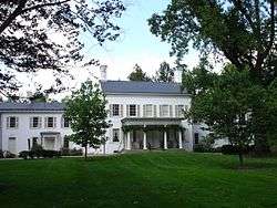 Morven |
January 25, 1971 (#71000503) |
55 Stockton St. 40°20′51″N 74°40′01″W |
Princeton | |
| 56 | Mott School and Second Street School |  Mott School and Second Street School |
April 15, 1986 (#86000809) |
Centre and 643-645 Second Sts. 40°12′07″N 74°45′24″W |
Trenton | |
| 57 | Mount Rose Distillery |  Mount Rose Distillery |
December 12, 1996 (#96001471) |
Address Restricted 40°22′03″N 74°44′49″W |
Hopewell | |
| 58 | Mountain Avenue Historic District |  Mountain Avenue Historic District |
February 2, 1995 (#94001604) |
73-143 Mountain Ave. 40°21′25″N 74°40′25″W |
Princeton | |
| 59 | Nassau Hall, Princeton University |  Nassau Hall, Princeton University |
October 15, 1966 (#66000465) |
Princeton University campus 40°20′55″N 74°39′34″W |
Princeton | |
| 60 | Old Barracks |  Old Barracks |
January 25, 1971 (#71000506) |
S. Willow St. 40°13′10″N 74°46′07″W |
Trenton | |
| 61 | Old Eagle Tavern |  Old Eagle Tavern |
November 3, 1972 (#72000801) |
431, 433 S. Broad St. 40°12′47″N 74°45′34″W |
Trenton | |
| 62 | Old Ryan Farm |  Old Ryan Farm |
September 10, 1971 (#71000507) |
Federal City Rd. 40°16′47″N 74°46′15″W |
Trenton | |
| 63 | Isaac Pearson House |  Isaac Pearson House |
February 1, 2006 (#05001568) |
Hobson Ave. at Emiline Ave. 40°11′16″N 74°42′44″W |
Hamilton Township | |
| 64 | Pennington Railroad Station |  Pennington Railroad Station |
December 31, 1974 (#74001170) |
Corner of Franklin and Green Ave. 40°19′58″N 74°47′41″W |
Pennington | |
| 65 | Penns Neck Baptist Church |  Penns Neck Baptist Church |
December 28, 1989 (#89002160) |
US 1 at Princeton-Hightstown Rd. 40°19′55″N 74°38′15″W |
Penns Neck | |
| 66 | Pennsylvania Railroad Bridge |  Pennsylvania Railroad Bridge |
June 6, 1979 (#79001502) |
Spans Delaware River 40°12′24″N 74°46′09″W |
Trenton | |
| 67 | Philadelphia and Reading Railroad Freight Station |  Philadelphia and Reading Railroad Freight Station |
May 14, 1979 (#79001503) |
260 N. Willow St. 40°13′34″N 74°46′03″W |
Trenton | |
| 68 | Joseph Phillips Farm |  Joseph Phillips Farm |
May 2, 1977 (#77000879) |
North of Titusville on Hunter Road 40°20′23″N 74°53′56″W |
Hopewell Township | Started by Joseph Phillips in 1732, now the Howell Living History Farm, which operates and preserves it as it was in 1900[25] |
| 69 | Pleasant Valley Historic District |  Pleasant Valley Historic District |
June 14, 1991 (#91000676) |
Centered on junction of Pleasant Valley Road with Woodens Lane and Hunter Road 40°20′18″N 74°53′44″W |
Hopewell Township | Extends into Hunterdon County |
| 70 | President's House |  President's House |
July 17, 1971 (#71000504) |
Nassau St. 40°20′56″N 74°39′36″W |
Princeton | |
| 71 | Princeton Battlefield | .JPG) Princeton Battlefield |
October 15, 1966 (#66000466) |
Princeton Battlefield State Park; also Roughly Quaker Rd. from Stockton Rd. to Stony Brook 40°19′45″N 74°40′36″W |
Princeton | Boundary increases approved October 10, 1989 and April 26, 2019 |
| 72 | Princeton Historic District |  Princeton Historic District |
June 27, 1975 (#75001143) |
Irregular pattern between Lytle St. and Haslet Ave. from Lovers Lane to Olden Sts. 40°20′48″N 74°39′51″W |
Princeton | |
| 73 | Princeton Ice Company | .jpg) Princeton Ice Company |
August 28, 2007 (#07000874) |
57 Mountain Ave. 40°21′26″N 74°40′17″W |
Princeton | |
| 74 | Prospect |  Prospect |
February 4, 1985 (#85002434) |
Princeton University campus 40°20′49″N 74°39′24″W |
Princeton | |
| 75 | Riverview Cemetery |  Riverview Cemetery |
March 27, 2017 (#100000810) |
870 Centre St. 40°11′42″N 74°45′12″W |
Trenton | |
| 76 | Roebling Machine Shop | 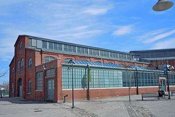 Roebling Machine Shop |
September 4, 1997 (#97000932) |
675 S. Clinton Ave. 40°12′35″N 74°45′11″W |
Trenton | Oldest surviving building in the Roebling complex, built innovative wire rope making machines[26] |
| 77 | John A. Roebling's Sons Company, Trenton N.J., Block 3 | .jpg) John A. Roebling's Sons Company, Trenton N.J., Block 3 |
August 22, 2012 (#12000528) |
Bounded by Hamilton Ave., Clark, Elmer, & E. Canal Sts. 40°12′46″N 74°45′19″W |
Trenton | Northern portion of Roebling complex, built wire for North Sea Mine Barrage, Golden Gate Bridge, among other structures |
| 78 | John Rogers House |  John Rogers House |
January 31, 1978 (#78001770) |
South of Princeton on S. Post Rd. 40°15′45″N 74°38′52″W |
West Windsor | |
| 79 | Sacred Heart Church |  Sacred Heart Church |
May 2, 2002 (#02000434) |
343 S. Broad St. 40°12′59″N 74°45′40″W |
Trenton | |
| 80 | Samuel Sloan House | 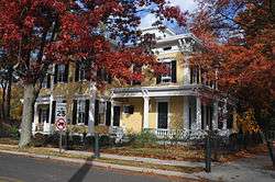 Samuel Sloan House |
March 28, 1974 (#74001168) |
238 S. Main St. 40°15′58″N 74°31′32″W |
Hightstown | |
| 81 | Smith-Ribsam House |  Smith-Ribsam House |
June 9, 1988 (#88000722) |
45 Pine Knoll Dr. 40°16′27″N 74°43′28″W |
Eldridge Park | |
| 82 | Somerset Roller Mills | 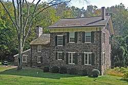 Somerset Roller Mills |
November 19, 1974 (#74001171) |
NJ 29 40°16′45″N 74°51′13″W |
Titusville | |
| 83 | St. Michael's Episcopal Church | 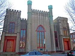 St. Michael's Episcopal Church |
April 29, 1982 (#82003280) |
140 N. Warren St. 40°13′20″N 74°45′55″W |
Trenton | |
| 84 | State House Historic District |  State House Historic District |
August 27, 1976 (#76001161) |
Roughly bounded by Capitol Plaza, Willow, State and Lafayette Sts. • Boundary increase (listed April 2, 1992, refnum 92000295): W. State St. south side, west of New Jersey State House 40°13′14″N 74°46′15″W |
Trenton | |
| 85 | Israel Stevens House |  Israel Stevens House |
March 15, 2005 (#05000176) |
2167 Brunswick Ave. 40°15′19″N 74°44′00″W |
Lawrence | |
| 86 | Stockton Street Historic District |  Stockton Street Historic District |
November 25, 2005 (#05001331) |
126-136 Stockton St., 219-237 Rogers Ave. 40°16′15″N 74°31′42″W |
Hightstown | |
| 87 | Stokely-Van Camp Industrial Complex |  Stokely-Van Camp Industrial Complex |
March 11, 1983 (#83001603) |
Lalor Street at Stokely Ave. 40°11′59″N 74°45′16″W |
Trenton | |
| 88 | Joseph Stout House |  Joseph Stout House |
October 29, 1974 (#74001169) |
Province Line Rd. 40°24′34″N 74°44′44″W |
Hopewell | |
| 89 | Titusville Historic District |  Titusville Historic District |
March 17, 1983 (#83001604) |
River Drive 40°18′22″N 74°52′44″W |
Titusville | |
| 90 | William Trent House |  William Trent House |
April 15, 1970 (#70000388) |
539 S. Warren St. 40°12′46″N 74°45′58″W |
Trenton | |
| 91 | Trenton and Mercer County War Memorial-Soldiers' and Sailors' Memorial Building |  Trenton and Mercer County War Memorial-Soldiers' and Sailors' Memorial Building |
December 11, 1986 (#86003480) |
W. Lafayette St. 40°13′06″N 74°46′06″W |
Trenton | |
| 92 | Trenton Battle Monument | 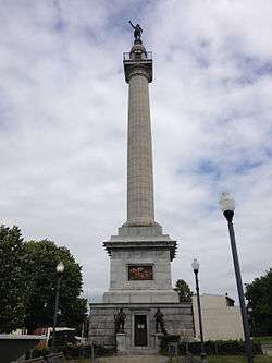 Trenton Battle Monument |
May 6, 1977 (#77000881) |
Warren and Broad Streets 40°13′33″N 74°45′53″W |
Trenton | Commemorates the Battle of Trenton |
| 93 | Trenton Central Office of the Bell Telephone Company |  Trenton Central Office of the Bell Telephone Company |
April 3, 2017 (#100000826) |
214-218 E. State St. 40°13′14″N 74°45′40″W |
Trenton | |
| 94 | Trenton City Hall |  Trenton City Hall |
January 30, 1978 (#78001771) |
309 State St. 40°13′12″N 74°45′34″W |
Trenton | |
| 95 | Trenton City/Calhoun Street Bridge | 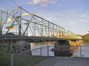 Trenton City/Calhoun Street Bridge |
November 20, 1975 (#75001621) |
Spans Delaware River between Morrisville, PA and Trenton, NJ 40°13′11″N 74°46′42″W |
Trenton | |
| 96 | Trenton Ferry Historic District |  Trenton Ferry Historic District |
June 26, 2013 (#13000355) |
Roughly bounded by South Broad and Federal Streets, the Delaware River and the Amtrak Northeast Corridor 40°12′36″N 74°45′34″W |
Trenton | Working class urban mixed-use neighborhood of row houses, duplexes, churches, and commercial buildings[27] |
| 97 | Trenton Friends Meeting House | 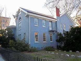 Trenton Friends Meeting House |
April 30, 2008 (#08000362) |
142 E. Hanover St. 40°13′16″N 74°45′46″W |
Trenton | |
| 98 | Trenton Jewish Community Center Bath House and Day Camp |  Trenton Jewish Community Center Bath House and Day Camp |
February 23, 1984 (#84002730) |
999 Lower Ferry Rd. 40°15′33″N 74°47′58″W |
Ewing Township | |
| 99 | Trenton Watch Company Building-Circle F Manufacturing Company Building |  Trenton Watch Company Building-Circle F Manufacturing Company Building |
April 3, 2017 (#100000827) |
720 Monmouth St. 40°13′02″N 74°44′48″W |
Trenton | |
| 100 | Tusculum | 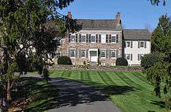 Tusculum |
January 5, 1978 (#78003171) |
North of Princeton on Cherry Hill Rd. 40°21′58″N 74°40′17″W |
Princeton | |
| 101 | U.S. Post Office and Courthouse | 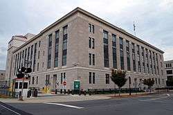 U.S. Post Office and Courthouse |
May 24, 2012 (#12000309) |
402 E. State St. 40°13′16″N 74°45′26″W |
Trenton | |
| 102 | University Cottage Club | 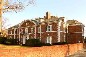 University Cottage Club |
November 19, 1999 (#99001315) |
51 Prospect Ave. 40°20′53″N 74°39′07″W |
Princeton | |
| 103 | Col. John Van Cleve Homestead | 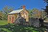 Col. John Van Cleve Homestead |
February 16, 1983 (#83001605) |
Northwest of Pennington on Poor Farm Rd. 40°21′11″N 74°49′27″W |
Hopewell Township | |
| 104 | Jeremiah Vandyke House |  Jeremiah Vandyke House |
March 29, 1978 (#78001769) |
Featherbed Lane 40°24′34″N 74°46′51″W |
Hopewell | |
| 105 | Washington Crossing State Park |  Washington Crossing State Park |
October 15, 1966 (#66000650) |
Titusville, New Jersey, on the Delaware River 40°17′57″N 74°52′07″W |
Titusville | |
| 106 | Washington Road Elm Allée | .jpg) Washington Road Elm Allée |
January 14, 1999 (#98001571) |
Washington Rd., bet. the Penns Neck Circle and The D&R Canal 40°20′08″N 74°38′37″W |
West Windsor | |
| 107 | Isaac Watson House | 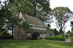 Isaac Watson House |
January 21, 1974 (#74001173) |
151 Westcott St. 40°11′25″N 74°43′39″W |
Hamilton Township | |
| 108 | John Welling House |  John Welling House |
March 14, 1973 (#73001110) |
Curlis Ave. at Birch St. 40°19′17″N 74°46′58″W |
Pennington | Rare example of a Dutch clapboard and shingle house[28] |
| 109 | West Trenton Station |  West Trenton Station |
June 22, 1984 (#84004031) |
Sullivan Way 40°15′27″N 74°48′57″W |
West Trenton | part of the Operating Passenger Railroad Stations TR |
| 110 | John White House |  John White House |
January 29, 1973 (#73001108) |
1 mile (1.6 km) north of Lawrenceville on Cold Soil Rd. 40°18′52″N 74°43′42″W |
Lawrenceville | |
| 111 | Windsor Historic District |  Windsor Historic District |
April 10, 1992 (#88001710) |
Roughly bounded by properties along Main St. and Church St. 40°14′27″N 74°35′06″W |
Robbinsville | |
| 112 | Witherspoon Street School for Colored Children |  Witherspoon Street School for Colored Children |
March 9, 2005 (#05000125) |
35 Quarry St. 40°21′19″N 74°39′46″W |
Princeton | |
| 113 | Jeremiah Woolsey House |  Jeremiah Woolsey House |
January 27, 1975 (#75001140) |
Southwest of Pennington on Washington Crossing Rd. 40°18′32″N 74°49′36″W |
Hopewell Township | Dutch Colonial house built 1765. Jeremiah Woolsey served as a commissioner to recruit men to serve in the Continental Army during the American Revolution.[29] |
Former listings
| [3] | Name on the Register | Image | Date listed | Date removed | Location | City or town | Summary |
|---|---|---|---|---|---|---|---|
| 1 | Princessville Inn |  Princessville Inn |
June 27, 1980 (#80002497) | June 11, 1982 | E of Lawrenceville at 3510 Princeton Pike |
Lawrence Township | Burned down, adjacent cemetery is extant |
See also
References
| Wikimedia Commons has media related to National Register of Historic Places in Mercer County, New Jersey. |
- The latitude and longitude information provided in this table was derived originally from the National Register Information System, which has been found to be fairly accurate for about 99% of listings. Some locations in this table may have been corrected to current GPS standards.
- "National Register of Historic Places: Weekly List Actions". National Park Service, United States Department of the Interior. Retrieved on June 19, 2020.
- Numbers represent an ordering by significant words. Various colorings, defined here, differentiate National Historic Landmarks and historic districts from other NRHP buildings, structures, sites or objects.
- "National Register Information System". National Register of Historic Places. National Park Service. April 24, 2008.
- The eight-digit number below each date is the number assigned to each location in the National Register Information System database, which can be viewed by clicking the number.
- "2008 Interpretive Plan for Abbott Farm NHL" (PDF). Mercer County Parks Commission. Retrieved 2013-09-19.
- "The Northeast". On the Record. National Park Service. Retrieved 2011-07-21.
- West, Helen almy (1954). A History of Hamilton Township, Mercer County, New Jersey. Trenton: Trenton Printing Company. pp. 18–19.
- Clark, William J. (July 1, 1976). "Abbott-Decou House". National Register of Historic Places. National Park Service.
- Lamar, Martha L.; Powell, L. Matthew; Davies, David S. (June 5, 1979). "Adams and Sickles Building". National Register of Historic Places. National Park Service.
- Nash, Winona D. (October 28, 1971). "Anderson-Capner House". National Register of Historic Places. National Park Service.
- Gottuso, George M. (March 13, 1979). "Baker-Brearley House". National Register of Historic Places. National Park Service.
- Bertland, Dennis; Armstrong, Janice (October 2011). "Bear Tavern Road/Jacob's Creek Crossing Rural Historic District" (PDF). National Register of Historic Places. National Park Service.
- Wolf, Gary (August 26, 1976). "Henry Clay and Bock & Co. Ltd. Cigar Factory". National Register of Historic Places. National Park Service.
- Stryker, William S. (1898). The Battles of Trenton and Princeton. Boston and New York: Houghton, Mifflin and Company. p. 270.
- "The History Archived 2009-10-01 at the Wayback Machine." Drumthwacket Foundation.
- Blake, Channing (March 10, 1973). "William Green House". National Register of Historic Places. National Park Service.
- Terry, Erik (October 28, 1997). "Green-Reading House". National Register of Historic Places. National Park Service.
- Greiff, Constance; Blake, Channing (September 8, 1971). "John D. Hart House". National Register of Historic Places. National Park Service.
- Greiff, Constance; Blake, Channing (September 1971). "Hart-Hoch House". National Register of Historic Places. National Park Service.
- English, Illona S. (March 1994). "Highfields". National Register of Historic Places. National Park Service.
- Fricker, Jonathan (July 12, 1977). "House at 379 West State Street". National Register of Historic Places. National Park Service.
- Zink, Clifford W. (October 15, 1986). "In and Out Social Club". National Register of Historic Places. National Park Service.
- Barucco, Suzanna (August 27, 2007). "Thomas Maddock's Sons Company". National Register of Historic Places. National Park Service.
- "Joseph Phillips Farm". National Register of Historic Places. National Park Service. June 1976.
- Hand, Susanne (April 17, 1997). "Roebling Machine Shop". National Register of Historic Places. National Park Service.
- Tvaryanas, Damon; Scott, Douglas; Hunter, Richard (November 26, 2012). "Trenton Ferry Historic District" (PDF). National Register of Historic Places. National Park Service.
- Greiff, Constance; Blake, Channing (September 8, 1971). "John Welling House". National Register of Historic Places. National Park Service.
- Israel, Nancy (October 1974). "Jeremiah Woolsey House". National Register of Historic Places. National Park Service.
| Topics |  | ||
|---|---|---|---|
| Lists by county | |||
| Lists by city |
| ||
| Other lists | |||
| |||
This article is issued from Wikipedia. The text is licensed under Creative Commons - Attribution - Sharealike. Additional terms may apply for the media files.