National Register of Historic Places listings in Passaic County, New Jersey
List of the National Register of Historic Places listings in Passaic County, New Jersey
| Atlantic - Bergen - Burlington - Camden - Cape May - Cumberland - Essex - Gloucester - Hudson - Hunterdon - Mercer - Middlesex - Monmouth - Morris - Ocean - Passaic - Salem - Somerset - Sussex - Union - Warren |

Location of Passaic County in New Jersey
This is intended to be a complete list of properties and districts listed on the National Register of Historic Places in Passaic County, New Jersey. The locations of National Register properties and districts (at least for all showing latitude and longitude coordinates below) may be seen in an online map by clicking on "Map of all coordinates".[1]
- This National Park Service list is complete through NPS recent listings posted June 19, 2020.[2]
| [3] | Name on the Register[4] | Image | Date listed[5] | Location | City or town | Description |
|---|---|---|---|---|---|---|
| 1 | Ailsa Farms |  Ailsa Farms |
April 30, 1976 (#76001181) |
300 Pompton Rd. 40°56′37″N 74°11′50″W |
Wayne | The Ailsa Farms estate is now William Paterson University. The estate's house (Haledon Hall) has been restored as Hobart Manor. |
| 2 | Arch Street Bridge over the Passaic River | 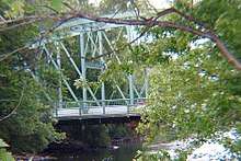 Arch Street Bridge over the Passaic River |
March 22, 2018 (#100002230) |
Arch St. over Passaic R. 40°55′24″N 74°10′12″W |
Paterson | |
| 3 | Aycrigg Mansion |  Aycrigg Mansion |
April 29, 1982 (#82003299) |
Main Ave. and Temple Pl. 40°51′02″N 74°07′30″W |
Passaic | |
| 4 | Belle Vista |  Belle Vista |
June 3, 1976 (#76001180) |
Valley Rd. in Garret Mountain Reservation 40°54′00″N 74°10′24″W |
Paterson | |
| 5 | Botany Worsted Mills Historic District | 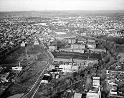 Botany Worsted Mills Historic District |
July 26, 1991 (#91000928) |
80-82 and 90 Dayton Ave. and 6-32 Mattimore St. 40°52′25″N 74°07′10″W |
Passaic | |
| 6 | Pietro Botto House |  Pietro Botto House |
July 30, 1974 (#74001188) |
83 Norwood St. 40°56′05″N 74°11′19″W |
Haledon | Also known as Pietro and Maria Botto House |
| 7 | Cathedral of St. John the Baptist |  Cathedral of St. John the Baptist |
December 16, 1977 (#77000903) |
Main and Grand Sts. 40°54′46″N 74°10′21″W |
Paterson | |
| 8 | Clinton Furnace |  Clinton Furnace |
June 18, 1976 (#76001179) |
Off NJ 23 at Clinton Reservoir 41°04′20″N 74°27′00″W |
Newfoundland | |
| 9 | Frederick William Cooke Residence |  Frederick William Cooke Residence |
July 8, 1982 (#82003302) |
384 Broadway 40°55′06″N 74°09′31″W |
Paterson | Destroyed by fire in 1991.[6] |
| 10 | Danforth Memorial Library | 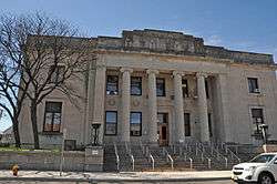 Danforth Memorial Library |
March 1, 1984 (#84002782) |
250 Broadway 40°55′05″N 74°09′52″W |
Paterson | |
| 11 | Dey Mansion | 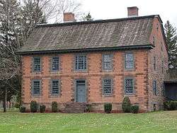 Dey Mansion |
December 18, 1970 (#70000392) |
199 Totowa Rd. 40°54′56″N 74°14′00″W |
Wayne | |
| 12 | Dundee Canal Industrial Historic District |  Dundee Canal Industrial Historic District |
January 21, 1999 (#98001640) |
George St., N along Dundee Canal, approx. 1.2 mi. to headgates opposite E. Clifton Ave. 40°52′25″N 74°07′12″W |
Passaic | |
| 13 | Eastside Park Historic District |  Eastside Park Historic District |
July 7, 2004 (#04000673) |
Roughly bounded by 20th, Vreeland, and 11th Aves., E. 33rd St. and Mclean Bvd. 40°54′53″N 74°08′13″W |
Paterson | |
| 14 | John W. Ferguson House |  John W. Ferguson House |
May 23, 1980 (#80002516) |
421 12th Ave. 40°55′11″N 74°08′46″W |
Paterson | Demolished in 1988.[7] |
| 15 | Goffle Brook Park |  Goffle Brook Park |
November 1, 2002 (#02001276) |
Goffle Rd., bet. Lafayette and MacFarlan Ave. 40°57′22″N 74°09′42″W |
Hawthorne | |
| 16 | Great Falls of Paterson/S.U.M. Historic District | 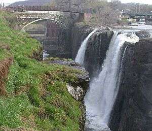 Great Falls of Paterson/S.U.M. Historic District |
April 17, 1970 (#86001507) |
At Passaic River 40°55′01″N 74°10′52″W |
Paterson | |
| 17 | Hinchliffe Stadium | 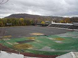 Hinchliffe Stadium |
March 22, 2004 (#04000223) |
Maple and Liberty Sts., overlooking the Great Falls of the Passaic 40°55′13″N 74°10′53″W |
Paterson | Listed as "National Register of Historic Places - Local Significance."
This error was never corrected. |
| 18 | Kossuth Street School |  Kossuth Street School |
April 10, 1980 (#80002515) |
47 Kossuth St. 40°56′17″N 74°11′01″W |
Haledon | |
| 19 | Long Pond Ironworks |  Long Pond Ironworks |
January 11, 1974 (#74001189) |
NE of West Milford on NJ 511 41°08′47″N 74°18′39″W |
West Milford | |
| 20 | Morris Canal |  Morris Canal |
October 1, 1974 (#74002228) |
Irregular line beginning at Phillipsburg and ending at Jersey City 40°41′08″N 75°09′49″W |
Not applicable | |
| 21 | Passaic County Court House and United States Custom House and Post Office Historic District | 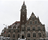 Passaic County Court House and United States Custom House and Post Office Historic District |
July 21, 2015 (#15000443) |
73-87, 63-65 Hamilton St. 40°54′49″N 74°10′17″W |
Paterson | |
| 22 | Passaic Elks Club | 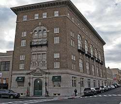 Passaic Elks Club |
December 28, 2005 (#05001485) |
29-31 Howe Ave. 40°51′46″N 74°07′40″W |
Passaic | |
| 23 | Paterson City Hall | 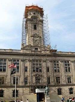 Paterson City Hall |
March 10, 1995 (#95000232) |
155 Market St. 40°55′00″N 74°10′19″W |
Paterson | |
| 24 | Paterson Downtown Commercial Historic District | 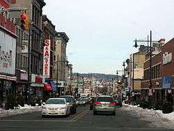 Paterson Downtown Commercial Historic District |
February 12, 1999 (#99000192) |
Roughly bounded by Patterson, Ward and Gross Sts., and Hamilton Ave. 40°55′02″N 74°10′21″W |
Paterson | |
| 25 | People's Bank and Trust Company Building |  People's Bank and Trust Company Building |
November 19, 2018 (#100003110) |
663 Main Ave. 40°51′40″N 74°07′35″W |
Passaic | |
| 26 | Public School Number Two | 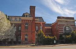 Public School Number Two |
March 8, 1978 (#78001790) |
Mill and Passaic Sts. 40°54′55″N 74°10′38″W |
Paterson | |
| 27 | John W. Rea House | 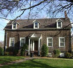 John W. Rea House |
September 17, 1999 (#99001168) |
675 Goffle Rd. 40°57′26″N 74°09′43″W |
Hawthorne | |
| 28 | Reinhardt Mills |  Reinhardt Mills |
May 9, 2003 (#03000393) |
283-297 21st Ave., 122-136 20th Ave., 46-72 Gray St., 45-67 State St. 40°54′28″N 74°09′43″W |
Paterson | |
| 29 | Ringwood Manor |  Ringwood Manor |
November 13, 1966 (#66000471) |
3 mi. E of Hewitt, Ringwood Manor State Park 41°08′40″N 74°15′10″W |
Ringwood | |
| 30 | Schuyler-Colfax House |  Schuyler-Colfax House |
April 3, 1973 (#73001133) |
2343 Paterson Hamburg Tpke. 40°59′15″N 74°16′47″W |
Wayne | |
| 31 | Skylands |  Skylands |
September 28, 1990 (#90001438) |
Ringwood State Park 41°07′30″N 74°14′14″W |
Ringwood | |
| 32 | Reynier Speer House |  Reynier Speer House |
July 18, 1985 (#85001566) |
612 Upper Mountain Ave. 40°51′37″N 74°12′11″W |
Little Falls | |
| 33 | St. John's Evangelical Lutheran Church |  St. John's Evangelical Lutheran Church |
May 7, 1982 (#82003301) |
140 Lexington Ave. 40°52′04″N 74°07′38″W |
Passaic | |
| 34 | St. Michael's Roman Catholic Church | 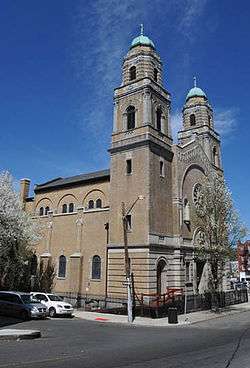 St. Michael's Roman Catholic Church |
December 15, 1978 (#78001791) |
74 Cianci St. 40°54′53″N 74°10′30″W |
Paterson | |
| 35 | St. Nicholas Roman Catholic Church | 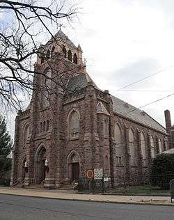 St. Nicholas Roman Catholic Church |
May 14, 1979 (#79001517) |
Washington, State and Ann Sts. 40°51′43″N 74°07′24″W |
Passaic | |
| 36 | Straight Street Bridge over the Passaic River | 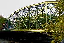 Straight Street Bridge over the Passaic River |
March 22, 2018 (#100002231) |
Straight St. over Passaic R. 40°55′35″N 74°09′58″W |
Paterson | |
| 37 | Daniel Thompson and John Ryle Houses | 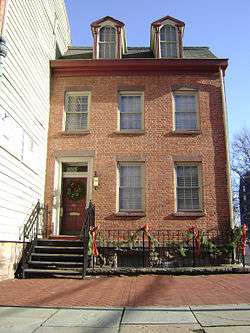 Daniel Thompson and John Ryle Houses |
July 30, 1981 (#81000398) |
8 and 9 Mill St. 40°54′59″N 74°10′42″W |
Paterson | |
| 38 | U.S. Animal Quarantine Station |  U.S. Animal Quarantine Station |
October 9, 1981 (#81000397) |
Clifton Ave. 40°52′05″N 74°09′43″W |
Clifton | |
| 39 | Van Riper-Hopper House |  Van Riper-Hopper House |
August 21, 1972 (#72000806) |
533 Berdan Ave. 40°58′40″N 74°14′34″W |
Wayne | |
| 40 | John and Anna Vreeland House |  John and Anna Vreeland House |
May 13, 1982 (#82003300) |
971 Valley Rd. 40°52′05″N 74°11′28″W |
Clifton | |
| 41 | Westside Park |  Westside Park |
March 7, 1973 (#73001132) |
114 Totowa Ave. 40°54′47″N 74°11′28″W |
Paterson |
Former listing
| [3] | Name on the Register | Image | Date listed | Date removed | Location | City or town | Summary |
|---|---|---|---|---|---|---|---|
| 1 | Van Duyne House | 1971 (#71001051) | 1976 | 636 Fairfield Rd. |
Mountain View | Relocated to 533 Berdan Ave., Wayne, in 1974 due to relocation of NJ 23, and was delisted due to relocation. |
See also
| Wikimedia Commons has media related to National Register of Historic Places in Passaic County, New Jersey. |
References
- The latitude and longitude information provided in this table was derived originally from the National Register Information System, which has been found to be fairly accurate for about 99% of listings. Some locations in this table may have been corrected to current GPS standards.
- "National Register of Historic Places: Weekly List Actions". National Park Service, United States Department of the Interior. Retrieved on June 19, 2020.
- Numbers represent an ordering by significant words. Various colorings, defined here, differentiate National Historic Landmarks and historic districts from other NRHP buildings, structures, sites or objects.
- "National Register Information System". National Register of Historic Places. National Park Service. April 24, 2008.
- The eight-digit number below each date is the number assigned to each location in the National Register Information System database, which can be viewed by clicking the number.
- "Archived copy" (PDF). Archived from the original (PDF) on 2011-08-19. Retrieved 2010-04-29.CS1 maint: archived copy as title (link) Accessed June 29, 2010
- "Archived copy" (PDF). Archived from the original (PDF) on 2011-08-19. Retrieved 2010-04-29.CS1 maint: archived copy as title (link) Accessed June 29, 2010.
| Topics | 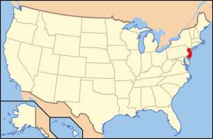 | ||
|---|---|---|---|
| Lists by county | |||
| Lists by city |
| ||
| Other lists | |||
| |||
Municipalities and communities of Passaic County, New Jersey, United States | ||
|---|---|---|
| Cities | Map of New Jersey highlighting Passaic County | |
| Boroughs | ||
| Townships | ||
| CDPs | ||
| Other unincorporated communities | ||
This article is issued from Wikipedia. The text is licensed under Creative Commons - Attribution - Sharealike. Additional terms may apply for the media files.