Nakla Upazila
Nakla (Bengali: নকলা) is an Upazila of Sherpur District in the Division of Mymensingh, Bangladesh.[1]
Nakla নকলা | |
|---|---|
Upazila | |
 Nakla Location in Bangladesh | |
| Coordinates: 24°59′N 90°11′E | |
| Country | |
| Division | Mymensingh Division |
| District | Sherpur District |
| Area | |
| • Total | 174.8 km2 (67.5 sq mi) |
| Population (1991) | |
| • Total | 162,952 |
| • Density | 930/km2 (2,400/sq mi) |
| Time zone | UTC+6 (BST) |
| Website | nokla |
Geography
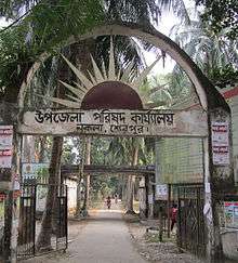
Nakla is located at 24.9833°N 90.1833°E. It has 33,482 units of household and total area 174.8 km2. The Nakla is free from Pakistani military, 9 December 1971. Pakistani military forces surrendered in the village named Pathakata. It is a historical place for Nakla. Every day many of tourists who are interested in its liberation war come to see the place. Nowadays there is a market named Pathakata Baazar.
Nakla is the major upazila of Sherpur district. Many famous persons were born there.
Demographics
As of the 1991 Bangladesh census, Nakla has a population of 162952. Males constitute 51.03% of the population, and females 48.97%. This Upazila's eighteen up population is 81345. Nakla has an average literacy rate of 22.4% (7+ years), and the national average of 32.4% literate.[2]
Administration
Nakla Upazila is divided into 9 union parishads: Baneshwardi, Chandrakona, Char Ashtadhar, Ganapaddi, Kursa Badagair, Nakla, Pathakata, Talki, and Urpha. The union parishads are subdivided into 88 mauzas and 117 villages.
See also
- Upazilas of Bangladesh
- Districts of Bangladesh
- Divisions of Mymensingh
References
- Muhammad Harunur Rashid (2012), "Nakla Upazila", in Sirajul Islam and Ahmed A. Jamal (ed.), Banglapedia: National Encyclopedia of Bangladesh (Second ed.), Asiatic Society of Bangladesh
- "Population Census Wing, BBS". Archived from the original on 2005-03-27. Retrieved November 10, 2006.
| Upazila/Thana: | ||
|---|---|---|
Headquarters: Mymensingh | ||
| Jamalpur District | 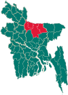 | |
| Mymensingh District | ||
| Netrokona District | ||
| Sherpur District | ||