Metro Vancouver Regional District
Metro Vancouver is a political body and corporate entity designated by provincial legislation as one of the regional districts in British Columbia, Canada.[5][6] The official legal name is the Metro Vancouver Regional District (MVRD). The organization was known as the Regional District of Fraser–Burrard for nearly one year upon incorporating in 1967, and as the Greater Vancouver Regional District (GVRD) from 1968 to 2017.
Metro Vancouver | |
|---|---|
| Metro Vancouver Regional District Greater Vancouver Regional District (1968–2017) Regional District of Fraser–Burrard (1967–1968) | |
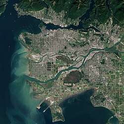 Satellite image of Metro Vancouver | |
 Logo | |
Major communities | |
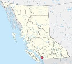 Location in British Columbia | |
| Country | Canada |
| Province | British Columbia |
| Incorporated[1] | June 29, 1967 |
| Name change[1] | June 13, 1968 |
| Name change[2] | January 30, 2017 |
| Office location | Burnaby |
| Government | |
| • Type | Regional district |
| • Body | Board of Directors |
| • Chair | Sav Dhaliwal (Burnaby) |
| • Vice chair | Linda Buchanan (North Vancouver) |
| • Electoral Areas | |
| Area (2016)[4] | |
| • Total | 2,882.68 km2 (1,113.01 sq mi) |
| Highest elevation | 1,990 m (6,530 ft) |
| Lowest elevation | 0 m (0 ft) |
| Population (2016)[4] | |
| • Total | 2,463,431 |
| • Density | 854.6/km2 (2,213/sq mi) |
| Canadian CD rank: 2nd | |
| Time zone | UTC−08:00 (PST) |
| • Summer (DST) | UTC−07:00 (PDT) |
| Area code(s) | 604 / 778 / 236 / 672 |
| Website | www |

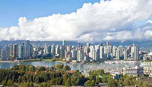
The MVRD is under the direction of 23 local authorities; it delivers regional services, sets policy and acts as a political forum. The regional district's most populous city is Vancouver, and Metro Vancouver's administrative offices are located in the City of Burnaby. The MVRD's boundaries match those of the Vancouver census metropolitan area (CMA) as identified by Statistics Canada. Metro Vancouver borders Whatcom County, Washington to the south, the Fraser Valley Regional District to the east, the Squamish-Lillooet Regional District to the north, and the Strait of Georgia to the west.
History
The Greater Vancouver Water District and the Greater Vancouver Sewerage and Drainage District were established in 1924 and 1956 respectively.[7] The Government of British Columbia incorporated a regional district for this western portion of the Lower Mainland named the Regional District of Fraser-Burrard on June 29, 1967.[1] Just under a year later, the regional district was renamed as the Greater Vancouver Regional District (GVRD) on June 13, 1968.[1]
In 2007, the GVRD applied to change its official legal name a second time to simply "Metro Vancouver", which was deemed more recognizable at the time.[8] British Columbia's Minister of Community Services denied the application due to the absence of the term "regional district" within the proposed new name, though it was suggested that the GVRD could brand itself under the unofficial name of Metro Vancouver.[8] After nine years, with growing public recognition of Metro Vancouver, the overall success of the brand, and confusion between the brand and the official legal name of the regional district, the GVRD motioned in 2016 to change its name to the Metro Vancouver Regional District.[8][9] The regional district was therefore formally renamed a second time by the Government of British Columbia on January 30, 2017 to the Metro Vancouver Regional District.[2]
Geography
The Metro Vancouver Regional District (MVRD) is located east of the Strait of Georgia and north of the State of Washington and is bisected by the Fraser River.[10] The boundaries of the MVRD match those of the Vancouver CMA.[10][11]
Demographics
| Metro Vancouver | ||
|---|---|---|
| Year | Pop. | ±% |
| 1891 | 21,887 | — |
| 1901 | 42,926 | +96.1% |
| 1911 | 164,020 | +282.1% |
| 1921 | 232,597 | +41.8% |
| 1931 | 347,709 | +49.5% |
| 1941 | 393,898 | +13.3% |
| 1951 | 562,462 | +42.8% |
| 1961 | 790,741 | +40.6% |
| 1971 | 1,028,334 | +30.0% |
| 1981 | 1,169,831 | +13.8% |
| 1991 | 1,602,590 | +37.0% |
| 1996 | 1,831,665 | +14.3% |
| 2001 | 1,986,965 | +8.5% |
| 2006 | 2,116,581 | +6.5% |
| 2011 | 2,313,328 | +9.3% |
| 2016 | 2,463,431 | +6.5% |
In the 2016 Census of Population conducted by Statistics Canada, the Metro Vancouver Regional District recorded a population of 2,463,431 living in 960,894 of its 1,027,613 total private dwellings, a change of 6.5% from its revised 2011 population of 2,313,328. With a land area of 2,882.68 km2 (1,113.01 sq mi), it had a population density of 854.6/km2 (2,213.3/sq mi) in 2016, making it the regional district in British Columbia with the greatest population and population density in British Columbia.[4]
| Canada 2016 Census[12] | Population | % of total population (2016) | |
|---|---|---|---|
| Visible minority group | Chinese | 474,655 | 19.6% |
| South Asian | 291,005 | 12% | |
| Filipino | 123,170 | 5.1% | |
| Korean | 52,980 | 2.2% | |
| Southeast Asian | 44,905 | 1.9% | |
| West Asian | 46,010 | 1.9% | |
| Latin American | 34,805 | 1.4% | |
| Japanese | 30,110 | 1.2% | |
| Black | 29,830 | 1.2% | |
| Arab | 16,430 | 0.7% | |
| Visible minority, n.i.e. | 6,490 | 0.3% | |
| Multiple visible minorities | 35,295 | 1.5% | |
| Total visible minority population | 1,185,680 | 48.9% | |
| European Canadian | 1,179,100 | 48.6% | |
| Aboriginal group | 61,455 | 2.5% | |
| Total population | 2,426,235 | 100% | |
Membership


This regional district comprises 23 local authorities as members: 21 municipalities, one electoral area and one treaty First Nation.[13]
| Metro Vancouver members | ||||
|---|---|---|---|---|
| Member[13] | Census subdivision type[14] | 2016 population[14] | 2011 population | Growth Rate
2011-2016 |
| Vancouver | City | 631,486 | 603,502 | 4.64% |
| Surrey | City | 517,887 | 468,251 | 10.60% |
| Burnaby | City | 232,755 | 223,218 | 4.27% |
| Richmond | City | 198,309 | 190,473 | 4.11% |
| Coquitlam | City | 139,284 | 126,804 | 9.84% |
| Langley | District municipality | 117,285 | 104,177 | 12.58% |
| Delta | City | 102,238 | 99,863 | 2.38% |
| North Vancouver | District municipality | 85,935 | 84,412 | 1.80% |
| Maple Ridge | City | 82,256 | 76,052 | 8.16% |
| New Westminster | City | 70,996 | 65,976 | 7.61% |
| Port Coquitlam | City | 58,612 | 55,958 | 4.74% |
| North Vancouver | City | 52,898 | 48,196 | 9.76% |
| West Vancouver | District municipality | 42,473 | 42,694 | -0.52% |
| Port Moody | City | 33,551 | 33,011 | 1.64% |
| Langley | City | 25,888 | 25,081 | 3.22% |
| White Rock | City | 19,952 | 19,339 | 3.17% |
| Pitt Meadows | City | 18,573 | 17,736 | 4.72% |
| Electoral Area A | Regional district electoral area | 16,133 | 12,988 | 24.21% |
| Bowen Island | Island municipality | 3,680 | 3,402 | 8.17% |
| Anmore | Village | 2,210 | 2,092 | 5.64% |
| Lions Bay | Village | 1,334 | 1,318 | 1.21% |
| Tsawwassen | Indian reserve (Treaty First Nation) | 816 | 720 | 13.33% |
| Belcarra | Village | 643 | 644 | -0.16% |
| Total Metro Vancouver Regional District | 2,463,431 | 2,313,328 | 6.49% | |
Electoral Area A comprises all unincorporated land within the regional district boundaries, which totals about 818 square kilometres. Most of the area is in the northernmost part of the district, including residential areas and isolated dwellings on Howe Sound between Lions Bay and Horseshoe Bay, on Indian Arm to the north of Deep Cove and Belcarra/Anmore and on the west side of Pitt Lake to the north of Port Coquitlam. Other areas included are Barnston Island on the Fraser River, Passage Island between Bowen Island and West Vancouver, and finally the urban communities of the University of British Columbia and the University Endowment Lands, in which 98% of the population of Electoral Area A lives.[15]
There are also seventeen Indian reserves within the geographical area that are not subject to governance by local authorities or the regional district; they have a combined population of 7,550 (2006).
The cities of Abbotsford and Chilliwack and the district of Mission, located to the east, although often linked to Vancouver in promotions and tourism, are part of a separate regional district, the Fraser Valley Regional District.
Governance
Metro Vancouver technically comprises four separate corporate entities: the Metro Vancouver Regional District (MVRD), the Greater Vancouver Sewerage and Drainage District (GVS&DD), the Greater Vancouver Water District (GVWD) and the Metro Vancouver Housing Corporation (MVHC).[5] Each of these is governed by a board of directors. The board of the MVRD has 40 directors coming from the 23 local authorities who are MVRD members.[16] The number of directors coming from each local authority is determined by population, and the number of votes allocated to each director further helps proportionally represent the population distribution of the region. Each board director is also an elected official of one of the local authorities, with the exception of the elected representative for Electoral Area A (which has no council).
As of 2017, the organization had about 1,500 employees.[17] The current organizational structure shows ten departments reporting to the Chief Administrative Officer:[18] Human Resources & Corporate Services; External Relations; Financial Services; Legal Services & Aboriginal Relations; Board & Information Services; Liquid Waste Services; Parks & Housing Services; Planning & Environment; Solid Waste Services; and Water Services.
Administrative role
The principal function of Metro Vancouver is to administer resources and services which are common across the metropolitan area. The Metro Vancouver Board has defined its strategic priorities for 2015 through 2018 in its Board Strategic Plan.[19]
The organization categorizes its work into eight action areas,[5] as described in the following subsections. However, 84% of the organization's budget is spent in three of those areas - the three utilities (water, liquid waste, solid waste).[5] Metro Vancouver's commitments and its members' commitments to each action area are outlined in eight board-approved management plans[20] as referenced below.
Water
Metro Vancouver's water utility is committed to the goals and strategies in the Drinking Water Management Plan,[21] as approved by the board. The three goals are:
- "Provide clean, safe drinking water"
- "Ensure the sustainable use of water resources"
- "Ensure the efficient supply of water"
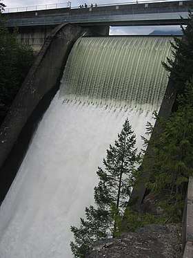
As noted, there are four legal entities that operate under the name Metro Vancouver: the GVWD, the GVS&DD, the MVRD and MVHC. The GVWD provides tap water to a land area covering more than 2,600 km² with all of the water coming from three sources: the Capilano reservoir, the Seymour reservoir and the Coquitlam reservoir. Metro Vancouver controls the Cleveland Dam on the Capilano reservoir, which supplies 40 percent of the district's water.[22]
Liquid waste
Metro Vancouver operates and maintains the liquid waste facility, which includes managing "the network of trunk sewers, pumping stations and wastewater treatment plants that connect with municipal sewer systems".[23] Throughout operations, the organization is committed to protecting public health and the environment, and recovering as much resources (energy, nutrients, etc.) as possible out of the waste stream.[5]
The liquid waste utility is committed to the goals and strategies in the Integrated Liquid Waste and Resource Management plan,[24] as approved by the board. The three goals are:
- "Protect public health and the environment"
- "Use liquid waste as a resource"
- "Effective, affordable and collaborative management"
Solid waste
Metro Vancouver's solid waste utility is committed to the goals and strategies in the Integrated Solid Waste and Resource Management plan,[25] as approved by the board. The four goals are:
- "Minimize waste generation"
- "Maximize reuse, recycling and material recovery"
- "Recover energy from the waste stream after material recycling"
- "Dispose of all waste in landfill after material recycling and energy recovery"
One initiative of the organization was the Ashcroft Manor Ranch Mega-Landfill Proposal in Ashcroft, British Columbia, in the Thompson Country of the British Columbia Interior, as there is no more room in the Lower Mainland for Metro Vancouver's garbage. A similar project nearby adjacent to the town of Cache Creek, British Columbia has almost reached capacity. Environmental concerns about the area's sensitive shrub-steppe climate and ecology are strong, while Highland Valley Copper, near Logan Lake, has offered the use of its mine-pit instead. Other MVRD landfill locations serving the regional district in the past have been in the Fraser Mills area, between the Trans-Canada Highway and the Fraser, and at Port Mann, beneath the south foot of the Port Mann Bridge.
Housing
Metro Vancouver owns and manages housing complexes throughout the region via the Metro Vancouver Housing Corporation (MVHC); it also forms policy on homelessness and affordable housing for the region. The MVHC's board-approved goals, as outlined in the Affordable Housing Strategy,[26] are:
- "Expand the supply and diversity of housing to meet a variety of needs"
- "Expand the rental supply and balance preservation of existing stock with redevelopment while supporting existing tenants"
- "Meet housing demand estimates for very low and low income earners"
- "Increase the rental housing supply along the frequent transit network
- "End homelessness in the region"
The MVHC's sole shareholder is the Metro Vancouver Regional District. The number of directors of the housing corporation is 13.[27]
Regional planning
Metro Vancouver works in collaboration with its members to achieve a shared vision of livability across the generations, as laid out in the Regional Growth Strategy (RGS),[28] which was approved by the board in 2011, replacing the Livable Region Strategic Plan (LRSP).[29] Th RGS requires each member local authority to provide a Regional Context Statement to "demonstrate to the Metro Vancouver Board how its Official Community Plan Supports the RGS."[5] The five goals of the RGS are:
- "Create a compact urban area"
- "Support a sustainable economy"
- "Protect the environment and respond to climate change impacts"
- "Develop complete communities"
- "Support sustainable transportation choices"
Regional planning also includes planning and policy-making in agriculture and the food industry. The organization is committed to the goals and strategies in the Regional Food System Strategy,[30] as approved by the board. The goals are:
- "Increased capacity to produce food close to home"
- "Improve the financial viability of the food sector"
- "People make healthy and sustainable food choices"
- "Everyone has access to healthy, culturally diverse and affordable food"
- "A food system consistent with ecological health"
The organization's board also adopted the Ecological Health Action Plan[31] which details actions to take advantage of opportunities "for Metro Vancouver to further contribute to the ecological health of the region." The opportunities identified are:
- "Advancing the regional green infrastructure network"
- "Supporting salmon in the cities"
- "Supplementing ecosystem services"
- "Reducing toxics"
Air quality
The organization runs programs and set policy to protect public health and the environment with respect to air quality, improve visual air quality and minimize the region's contribution to climate change.[5] The organization is committed to the goals and strategies in the Integrated Air Quality and Greenhouse Gas Management Plan,[32] as approved by the board. The three goals are:
- "Protect public health and the environment"
- "Improve visual air quality"
- "Minimize the region's contribution to global climate change"
Regional parks
The parks department of Metro Vancouver oversees the development and maintenance of 23[33] regional parks, as well as various nature reserves and greenways. The organization is committed to the goals and strategies in the Regional Parks Plan,[34] as approved by the board. The four goals are:
- "Promote ecological health"
- "Promote outdoor recreation for human health and wellness"
- "Support community stewardship, education and stewardships"
- "Promote philanthropy and economic opportunities"
Regional parks are distinct from municipal parks in that they are typically more "wild" and represent unique geographical zones within the region, such as bogs and mature rainforests.
Regional federation
Metro Vancouver undertakes support functions that underpin the rest of its service areas. In these areas, the organization commits to "contribute to the effective and efficient performance of our regional roles through leadership and collaboration with our members and other stakeholders." There are eight strategic directions guiding work in this area:[19]
- "Livable and sustainable region: Use livability and sustainability objectives to guide Metro Vancouver services and operations."
- "Effective federation: Strengthen the alignment of member and regional objectives."
- "Public education: Increase Metro Vancouver's profile by leveraging events and news related to regional services."
- "Engagement: Enhance relationships between Metro Vancouver and other orders of government, First Nations and stakeholders."
- "Regional transportation: Advocate the merits of integrating regional land use and transportation planning."
- "Regional prosperity: Clarify and strengthen Metro Vancouver's role in pursuing a collaborative approach to regional prosperity."
- "Emergency preparedness: Collaborate with stakeholders to prepare for major emergencies."
- "Fiscal responsibility: Use value for service to guide Metro Vancouver operations and service provision."
The organization's board has also adopted the Corporate Climate Action Plan,[35] the purpose of which is to, "set out strategies and actions to achieve Metro Vancouver's commitment to corporate carbon neutrality and to adapt [its] corporate infrastructure and activities to the anticipated consequences of climate change." The strategies of the plan are:
- "Reduce energy consumption"
- "Switch to renewable energy"
- "Maximize energy recovery"
- "Sequester and remove carbon"
- "Adapt existing infrastructure and operations"
- "Plan and build resilient new infrastructure and facilities"
See also
- Greater Vancouver
- Greater Victoria, British Columbia
References
- "Order in Council No. 1873/1968". Government of British Columbia. 13 June 1968. Retrieved 20 February 2017.
- "Order of the Lieutenant Governor in Council: Order in Council No. 023, Approved and Ordered January 30, 2017". 30 January 2017. Retrieved 20 February 2017.
- Metro Vancouver. "Boards and committees". Retrieved 4 July 2007.
- "Population and dwelling counts, for Canada, provinces and territories, and census divisions, 2016 and 2011 censuses – 100% data (British Columbia)". Statistics Canada. 8 February 2017. Retrieved 19 February 2017.
- Metro Vancouver (January 2013). "2013 Action Plan" (PDF). Archived from the original (PDF) on 17 September 2013. Retrieved 30 January 2013.
- "Goodbye GVRD, hello Metro Vancouver". Vancouver Sun. 2 August 2007. Retrieved 1 March 2012.
- "Metro Vancouver history". Metro Vancouver. Retrieved 19 February 2017.
- "Metro Vancouver Legal Entities Name Change" (PDF). Metro Vancouver. 1 September 2016. Archived from the original (PDF) on 20 February 2017. Retrieved 19 February 2017.
- "Metro Vancouver Name Change". Metro Vancouver. Archived from the original on 20 February 2017. Retrieved 19 February 2017.
- Census Division 5915: Greater Vancouver, RD (PDF) (Map). Statistics Canada. 2016. Retrieved 19 February 2017.
- Census Metropolitan Area 933: Vancouver (PDF) (Map). Statistics Canada. 2016. Retrieved 19 February 2017.
- Census Profile, 2016 Census: Greater Vancouver, Regional district. Statistics Canada. Retrieved 2 April 2018.
- "Member Municipalities". Metro Vancouver. Retrieved 19 February 2017.
- "Population and dwelling counts, for Canada, provinces and territories, and census subdivisions (municipalities), 2016 and 2011 censuses – 100% data (British Columbia)". Statistics Canada. 8 February 2017. Retrieved 19 February 2017.
- "About Electoral Area A". Metro Vancouver. Metro Vancouver. Retrieved 13 September 2018.
- Metro Vancouver. "Board Members". Retrieved 10 December 2018.
- Metro Vancouver. "Departments". Retrieved 7 February 2017.
- "Departments". Retrieved 14 December 2018.
- "Metro Vancouver Board Strategic Plan 2015 to 2018" (PDF).
- "Compendium of Regional Management Plans". Archived from the original on 21 February 2013. Retrieved 14 February 2013.
- Metro Vancouver (January 2011). "Metro Vancouver Drinking Water Management Plan" (PDF). Archived from the original (PDF) on 27 August 2013. Retrieved 14 February 2013.
- Metro Vancouver Water Sources & Supply
- Wastewater Collection & Treatment Archived 21 February 2013 at the Wayback Machine. Metrovancouver.org. Retrieved on 2013-07-26.
- Metro Vancouver (May 2010). "Integrated Liquid Waste and Resource Management" (PDF). Archived from the original (PDF) on 16 September 2012. Retrieved 14 February 2013.
- Metro Vancouver (July 2010). "Integrated Solid Waste and Resource Management" (PDF). Archived from the original (PDF) on 17 September 2013. Retrieved 14 February 2013.
- Metro Vancouver (20 June 2016). "Metro Vancouver Regional Affordable Housing Strategy" (PDF). Retrieved 15 May 2019.
- Metro Vancouver (19 February 2013). "Greater Vancouver Regional District Regular Board Meeting Friday, February 22, 2013" (PDF). Retrieved 26 February 2013.
- Metro Vancouver (29 July 2011). "Regional Growth Strategy" (PDF). Archived from the original (PDF) on 24 December 2012. Retrieved 14 February 2013.
- Metro Vancouver (December 1999). "Livable Region Strategic Plan" (PDF). Archived from the original (PDF) on 24 December 2012. Retrieved 24 October 2012.
- Metro Vancouver (February 2010). "Regional Food System Strategy" (PDF). Archived from the original (PDF) on 22 December 2012. Retrieved 14 February 2013.
- Metro Vancouver (October 2011). "Ecological Health Action Plan" (PDF). Archived from the original (PDF) on 29 August 2013. Retrieved 14 February 2013.
- Metro Vancouver (October 2011). "Integrated Air Quality and Greenhouse Gas Management Plan" (PDF). Archived from the original (PDF) on 27 August 2013. Retrieved 14 February 2013.
- "Regional Parks, Greenways & Reserves". Metro Vancouver. Retrieved 7 February 2017.
- Metro Vancouver (28 October 2011). "Regional Parks Plan" (PDF). Archived from the original (PDF) on 27 August 2013. Retrieved 14 February 2013.
- Metro Vancouver (16 June 2010). "Corporate Climate Action Plan" (PDF). Retrieved 14 December 2018.
External links
Municipalities of Metro Vancouver | |
|---|---|
| Population over 500,000 | |
| Population over 100,000 | |
| Population over 50,000 | |
| Population over 10,000 | |
| Population under 10,000 | |
| Unincorporated areas | |
| |
Places adjacent to Metro Vancouver Regional District | ||||||||||
|---|---|---|---|---|---|---|---|---|---|---|
| ||||||||||
| Subdivisions |  | |
|---|---|---|
| Communities | ||
| Metro areas and agglomerations |
| |
| Regional districts |
| |
| ||