Lions Bay
Lions Bay is a small, mostly residential community in British Columbia, Canada, located between Vancouver and Squamish on the steep eastern shore of Howe Sound. Lions Bay is the 35th least populous of BC's 264 municipalities, with an official 2016 census population of 1,334, and is 10th smallest by land area, at 2.51 km2. Originally a boat-access summer camping destination for Vancouverites, Lions Bay began to be permanently settled in the 1960s. The community incorporated as a village municipality in January 1971.
Lions Bay | |
|---|---|
| Village of Lions Bay[1] | |
| Motto(s): Splendour in Serenity | |
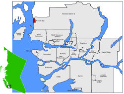 Location of Lions Bay within the Greater Vancouver Regional District in British Columbia, Canada | |
| Coordinates: 49°27′29″N 123°14′13″W | |
| Country | |
| Province | |
| Region | Howe Sound |
| Regional District | Metro Vancouver |
| Government | |
| • Mayor | Ron McLaughlin |
| • Councillors | List
|
| • MP | Pamela Goldsmith-Jones (Liberal) |
| • MLA | Jordan Sturdy (Liberal) |
| Area | |
| • Total | 2.53 km2 (0.98 sq mi) |
| Population (2016) | |
| • Total | 1,334 |
| • Density | 526.5/km2 (1,364/sq mi) |
| Time zone | UTC−8 (PST) |
| • Summer (DST) | UTC−7 (PDT) |
| Area code(s) | 604 |
| Website | |
Names around Lions Bay
- 1792, Capt. Vancouver named Howe Sound for Adm. Richard Howe RN, and Anvil Island for its shape
- 1857-61, Capt. Richards of the survey sloop HMS Plumper named many features in Howe Sound after aspects of 1794's "Battle of the Glorious First" fought by Adm. Howe:
- Mt. Harvey, Harvey Creek, Mt. Brunswick and Brunswick Beach for Capt. John Harvey of HMS Brunswick
- Gambier Island for Capt. James Gambier
- Bowyer Island for Adm. George Bowyer
- Bowen Island for James Bowen, master of HMS Queen Charlotte
- The Lions, the twin peaks of an extinct volcano above the village, were named in 1889 by a Judge Gray in Vancouver, for their supposed resemblance to Landseer's lions statues around Nelson's Column in London's Trafalgar Square. They are the Transformed Sisters, Ch'ich'iyúy Elxwíkn, of Coast Salish legend.
- Alberta Bay, Alberta Creek: after the province, after Queen Victoria's daughter.
- Kelvin Grove, a developer name, ultimately from Glasgow's Kelvin river.
Amenities
Lions Bay Beach Park has restroom and change facilities (refurbishment commencing in 2018), a sandy beach protected by a log boom, and a float. Pay parking is available for visitors. The Kelvin Grove Beach and Marine park 500 meters south also has a restroom and is a popular scuba destination. Brunswick Beach a kilometer north has no facilities or visitor parking.
In the 2017–18 school year School District 45's Lions Bay School has about 30 K-3 pupils, down from peak levels in prior years of 60–80. After Grade 3, public school students are bused to the K-7 Gleneagles Elementary (approx. 60 Lions Bay students out of 240) and the Grade 8–12 Rockridge Secondary (approx. 80 students from Lions Bay out of 800).
A volunteer fire department with 30+ highly trained members provides in-Village, wildfire and MVA rescue on the Sea-to-Sky Highway 99. Many members go on to permanent roles at professional departments; a training at Lions Bay Fire Rescue is considered one of the best available in western Canada.
Volunteer-maintained trails run through the community, and there is cheap multi-day pay parking available at the Sunset trailhead to popular regional hikes.
Commercially there is a general store with Rural Liquor Outlet, a café (including on-tap beers for on-premise consumption), a real estate office, a 150-boat dry-storage marina and a marine service centre.
Infrastructure
Under license from the Province, water is drawn from intakes on Harvey and Magnesia Creeks, and disinfected in two modern dual-barrier (UV and chlorine) treatment plants. Surface supply is sufficient year-round for a consumption on the order of 300,000 USGPD in winter and 500,000 GPD in summer (a relatively high per-capita consumption rate regionally). A long-range hydrology study underway in partnership with the Civil Engineering department at UBC is modelling the hydrological characteristics of the groundwater catchments above the village, and in 2017 the municipality purchased the last piece of available waterfront land to hold in long-term reserve for a possible future desalination plant need.
100 houses in the Kelvin Grove area are on central sewer to a small secondary wastewater treatment plant; the remaining residences and businesses rely on individual onsite wastewater systems (septic systems), many approaching their 30–50 year design lives.
As part of the regional TransLink transit network, Lions Bay is served by the hourly 262 route.
The provincial Sea-to-Sky Highway 99 (three overpass/underpass intersections) and federal CN Rail (three at-grade road crossings) run through the community.
Lions Bay is not supplied with natural gas, so wintertime heating is supplied by electrical resistance heating, heat pumps, oil furnaces, and wood-burning in a variety of appliances ranging from open fireplaces to airtights and pellet stoves. Local and regional awareness campaigns will get underway in 2018 to address occasionally marginal wintertime air quality.
Geology and geomorphology
Bedrock geology consists of lower-Cretaceous Gambier Group marine sedimentary and volcanic rocks. Outcrops primarily consist of greenish volcanic rock that is highly fractured (10 cm fracture spacing) with red oxidation on exposed surfaces. Upslope, the headwaters of Magnesia, Alberta and Harvey Creeks are underlain by mid-Cretaceous era "Coast Plutonic Complex" rock, which has intruded into the older Gambier rocks. Prominent northwest trending faults and jointing creates structural discontinuities that may be source of instability.
Geomorphology in the area is a product of glaciation and post-glacial erosion. The last, or Fraser, glaciation began 33,500 years ago and reached its peak 17,500 years ago. Ice retreat was delayed several thousand years by grounding, with several minor readvances forming the "Porteau end moraine." Glacial marine sedimentation (mud with stones dropped from icebergs) is believed to have ceased by 10,600 yr BP. The weight of Pleistocene ice depressed the land surface so during deglaciation, the sea flooded the land to a level of up to 220 m higher than today. Sea-level fell rapidly as the land rebounded such that by about 10,000 years ago sea level was 10 m below present, but by 5700 years ago it was at approximately modern levels. Following deglaciation, erosion rapidly reworked glacial sediments, declining in rate over time such that by no later than 7,500 years ago the landscape was similar to today. In post-glacial times erosion by water and mass movement (debris slides, debris flows, rockfall, rock avalanches, snow avalanches) will have continued to rework bedrock and soil-mantled slopes. Steep rockfall aprons have developed on mid to lower slopes. Magnesia, Alberta and Harvey Creeks have become incised into their debris cones and alluvial fans have formed at their mouths into the ocean.[2]
Climate
Howe Sound at Lions Bay experiences a maritime climate with moderated temperature regime and winter precipitation peak driven by cyclonic storms. Temperatures are cool from December through February, rising to a peak in July and August. There is a pronounced precipitation peak starting in October and extending through January, diminishing to a low in June through September. Precipitation is strongly enhanced with elevation as mountain slopes drive air masses upward, a phenomenon known as orographic uplift. Annually, approximately 2000 mm precipitation falls at sea -level, increasing to 4000 mm at the ridge crest. Assuming a wet snow density of 50%, then 15 cm of snow, amounting to 5% of winter precipitation, may be experienced at sea -level, increasing to 1 m, or 25% of winter precipitation, at mid elevation and 3 m, or 50% of winter precipitation, at the ridge crest. This indicates that at mid and high elevations, both rain and rain-on- snow are important drivers of winter runoff.
| Climate data for Lions Bay | |||||||||||||
|---|---|---|---|---|---|---|---|---|---|---|---|---|---|
| Month | Jan | Feb | Mar | Apr | May | Jun | Jul | Aug | Sep | Oct | Nov | Dec | Year |
| Record high °C (°F) | 16 (61) |
17 (63) |
22 (72) |
24 (75) |
28.5 (83.3) |
32.5 (90.5) |
34 (93) |
33.5 (92.3) |
30.5 (86.9) |
23.5 (74.3) |
16.5 (61.7) |
17 (63) |
34 (93) |
| Average high °C (°F) | 6.1 (43.0) |
7.7 (45.9) |
10.5 (50.9) |
13.9 (57.0) |
17.1 (62.8) |
20.1 (68.2) |
22.7 (72.9) |
22.4 (72.3) |
19.8 (67.6) |
13.5 (56.3) |
8.2 (46.8) |
5.3 (41.5) |
13.9 (57.0) |
| Daily mean °C (°F) | 3.8 (38.8) |
4.9 (40.8) |
7.2 (45.0) |
9.9 (49.8) |
12.9 (55.2) |
15.9 (60.6) |
18.3 (64.9) |
18 (64) |
15.5 (59.9) |
10.4 (50.7) |
5.9 (42.6) |
3.2 (37.8) |
10.5 (50.9) |
| Average low °C (°F) | 1.5 (34.7) |
2.1 (35.8) |
3.7 (38.7) |
6 (43) |
8.7 (47.7) |
11.5 (52.7) |
13.8 (56.8) |
13.6 (56.5) |
11.1 (52.0) |
7.3 (45.1) |
3.5 (38.3) |
1.2 (34.2) |
7 (45) |
| Record low °C (°F) | −8 (18) |
−12 (10) |
−4 (25) |
1 (34) |
2.5 (36.5) |
6 (43) |
9 (48) |
9.5 (49.1) |
5.5 (41.9) |
−3.5 (25.7) |
−12.5 (9.5) |
−11 (12) |
−12.5 (9.5) |
| Average precipitation mm (inches) | 229 (9.0) |
161 (6.3) |
161 (6.3) |
139 (5.5) |
101 (4.0) |
79 (3.1) |
55 (2.2) |
63 (2.5) |
71 (2.8) |
198 (7.8) |
289 (11.4) |
212 (8.3) |
1,757 (69.2) |
| Average rainfall mm (inches) | 218 (8.6) |
152 (6.0) |
158 (6.2) |
139 (5.5) |
101 (4.0) |
79 (3.1) |
55 (2.2) |
63 (2.5) |
71 (2.8) |
198 (7.8) |
286 (11.3) |
202 (8.0) |
1,722 (67.8) |
| Average snowfall cm (inches) | 10.5 (4.1) |
8.3 (3.3) |
3.1 (1.2) |
0 (0) |
0 (0) |
0 (0) |
0 (0) |
0 (0) |
0 (0) |
0.2 (0.1) |
2.6 (1.0) |
10.7 (4.2) |
35.3 (13.9) |
| Source: [3] | |||||||||||||
Governance, demographics and politics
Lions Bay is a self-governing municipality with an elected mayor and four councillors setting policy. Execution of policy and administration is managed by a chief administrative officer or CAO, through five staff working out of the municipal offices, and five at the Frank Smith Works Yard. The village's Klatt Public Safety Building houses the 30-volunteer Fire Department, an ambulance station leased to the BC Ambulance Service, and Lions Bay Search & Rescue. Policing is provided by the Squamish RCMP detachment. Lions Bay is part of the Metro Vancouver Regional District (but does not currently participate in its water, drainage or sewer functions). The mayor is a member of Translink's Mayors' Council, one of its several quasi-governing bodies.
In the Canada 2016 Census, Lions Bay's official population was 1,334, making it the 38-smallest municipality in BC (the Canadian census only counts citizens and permanent residents). The actual 2018 population is estimated at 1550.
In 2018 Lions Bay's average residential non-rural property assessment of $1.62 mil. was the fourth-highest of all assessment areas in the province, behind only the University Endowment Lands ($3.51 million.), West Vancouver ($3.24 million.) and Anmore ($1.65 million.).
In the 2017 provincial elections, 567 of Lions Bay's approx. 1000 eligible voters voted 43% Liberal (centre-right), 28% Green, and 18% NDP (left). Politics besides, Lions Bayers tend to support environmental causes, such as the UNESCO Biosphere initiative for Howe Sound and glass-sponge reef protection. Lions Bay residents are generally opposed to reindustrialisation of Howe Sound, including Woodfibre LNG, McNab Creek Gravel, and clearcut woodblocks.
The municipality is small, with a 2017 operating budget of $3.3 mil. (raised 50% by taxes, 50% by fees plus grants). 2017 per-parcel taxes, utility & fees of $7,647 were the 2nd highest municipality in BC. The 2017 operating budget was:
- $1.2 mil. for 11.15 FTE staff
- $819,000 water operating cost ($1,420 per connection)
- $416,000 volunteer fire department ($720 per residence)
- $865,000 everything else.
Capital spending on infrastructure, parks and buildings is funded by federal and provincial grants, debt, and occasionally taxation when the spend is overdue. In 2017, for example, a $2.71 mil. capital project to replace and remove four water tanks and improve water distribution network was 50% funded by the federal government, 33% by the provincial government, and 17% by 30-year debt funding for the local contribution (with 92% Yes voter approval in a 2017 referendum).
Lions Bay Search and Rescue
Lions Bay Search and Rescue was established in the 1980s following a series of landslides which caused a number of deaths and briefly cut the highway and isolated the village.[4] Although initially set up to provide the village with a measure of self-sufficiency in an emergency, the Search and Rescue team developed over time into a primarily mountain rescue group. The twin peaks The Lions above the village give it its name, and are known in First Nations stories as The Sisters; they are prominently visible from Vancouver, and attract large numbers of hikers and climbers, especially in warmer months. Hiking trails in the area of the Lions are rough and demanding (a hike from Lions Bay to the top of the West Lion gains 1500 meters in elevation with a round trip travel time of 6–8 hours for fit hikers). Every year an increasing number of hikers are injured, lost or caught out in the dark while hiking in this area, increasing demand on Lions Bay Search and Rescue in cooperation with the Provincial Emergency Program.
Places adjacent to Lions Bay | ||||||||||
|---|---|---|---|---|---|---|---|---|---|---|
| ||||||||||
References
- "British Columbia Regional Districts, Municipalities, Corporate Name, Date of Incorporation and Postal Address" (XLS). British Columbia Ministry of Communities, Sport and Cultural Development. Archived from the original on July 13, 2014. Retrieved November 2, 2014.
- "Lions Bay geology" (PDF).
- "Calculation Information for 1981 to 2010 Canadian Normals Data". Environment Canada. Archived from the original on June 14, 2013. Retrieved July 9, 2013.
- About us, Lions Bay Search and Rescue
Municipalities of Metro Vancouver | |
|---|---|
| Population over 500,000 | |
| Population over 100,000 | |
| Population over 50,000 | |
| Population over 10,000 | |
| Population under 10,000 | |
| Unincorporated areas | |
| |
| Subdivisions |  | |
|---|---|---|
| Communities | ||
| Metro areas and agglomerations |
| |
| Villages |
| |
| ||
| Authority control |
|
|---|