Regional Municipality of Niagara
The Regional Municipality of Niagara, also colloquially known as the Niagara Region, is a regional municipality comprising twelve municipalities of Southern Ontario, Canada. The regional seat is in Thorold. It is the southern end of the Golden Horseshoe, the largest megalopolis in Canada.
Regional municipality (upper-tier) | |
| Regional Municipality of Niagara Municipalité régionale de Niagara (French) | |
Clockwise: Niagara Falls, Skylon Tower, Downtown St. Catharines, Welland Canal in Port Colborne, Clifton Hill in Niagara Falls, Ontario | |
 Flag | |
| Motto(s): Unity, Responsibility, Loyalty | |
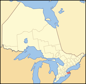 Location of Niagara within Ontario | |
| Coordinates: 43°03′N 79°18′W | |
| Country | |
| Province | |
| Formed | 1970 (from Welland and Lincoln Counties) |
| Seat | Thorold |
| Government | |
| • Chair | Jim Bradley |
| • Governing body | Niagara Regional Council |
| • MPs | Dean Allison, Chris Bittle, Vance Badawey, Rob Nicholson |
| • MPPs | Jeff Burch, Wayne Gates, Sam Oosterhoff, Jennie Stevens |
| Area | |
| • Land | 1,854.23 km2 (715.92 sq mi) |
| Population (2016)[1] | |
| • Total | 447,888 |
| • Density | 241.5/km2 (625/sq mi) |
| Time zone | UTC-5 (Eastern (EST)) |
| • Summer (DST) | UTC-4 (EDT) |
| Website | www.niagararegion.ca |

.jpg)
.jpg)

The region occupies most of the Niagara Peninsula. Its eastern boundary is the Niagara River, which is also the border with the United States. It is bounded on the north by Lake Ontario and on the south by Lake Erie.
Unique natural landscapes make the Niagara Region an important centre for agriculture and tourism in Canada. The most important agricultural enterprise in Niagara is viticulture, or winemaking. The Niagara Wine Route, which connects visitors to dozens of wineries, is a growing tourism draw while the internationally renowned Niagara Falls is one of Canada's major tourist attractions. Along with Shaw Festival, held annually in Niagara-on-the-Lake, and the Welland Canal, the Regional Municipality of Niagara receives up to 12 million visitors each year
Administrative divisions

Cities
- Niagara Falls (part of Welland sub-region)
- Port Colborne (part of Welland sub-region)
- St. Catharines (part of Lincoln sub-region)
- Thorold (part of Welland sub-region)
- Welland (part of Welland sub-region)
Towns
- Fort Erie (part of Welland sub-region)
- Grimsby (part of Lincoln sub-region)
- Lincoln (part of Lincoln sub-region)
- Niagara-on-the-Lake (part of Lincoln sub-region)
- Pelham (part of Welland sub-region)
Townships
- Wainfleet (part of Welland sub-region)
- West Lincoln (part of Lincoln sub-region)
Demographics
| Canada census – Regional Municipality of Niagara community profile | |||
|---|---|---|---|
| 2016 | 2011 | 2006 | |
| Population: | 447,888 (+3.8% from 2011) | 431,346 (+0.9% from 2006) | 427,421 (+4.1% from 2001) |
| Land area: | 1,854.23 km2 (715.92 sq mi) | 1,854.25 km2 (715.93 sq mi) | 1,854.17 km2 (715.90 sq mi) |
| Population density: | 241.5/km2 (625/sq mi) | 232.6/km2 (602/sq mi) | 230.5/km2 (597/sq mi) |
| Median age: | 45.7 (M: 44.4, F: 46.9) | 41.9 (M: 40.7, F: 42.9) | |
| Total private dwellings: | 196,241 | 188,877 | 179,903 |
| Median household income: | $65,086 | ||
| References: 2016[2] 2011[3] 2006[4] earlier[5] | |||
- Population in 2001: 410,574
- Population in 1996: 403,504
Racial groups[4]
- White: 388,415 or 92.1%
- Black: 5,210 or 1.2%
- Multiracial: 845 or 0.2%
- Chinese: 3,760 or 0.9%
- Other Asian: 12,045 or 2.9%
- (based on single responses)
Religious profile[4]
- 43.2% Protestant
- 36.4% Roman Catholic
- 14.6% Non-religious
- 3.8% other Christian
- 0.9% Muslim
Top ten largest ethnicities[4]
Features
Education
- Brock University (St. Catharines)
- Conseil Scolaire Viamonde - French Public
- District School Board of Niagara - Public
- Niagara Catholic District School Board - Separate
- Niagara College (Niagara-on-the-Lake, Welland)
- Niagara Parks Commission School of Horticulture (Niagara Falls, Ontario)
Festivals and major events
- Canada Games - 2021
- Canal Days (Port Colborne)
- Festival of Lights
- FISA World Rowing Championships - 1970 & 1999
- Shaw Festival
- Niagara Pumphouse Arts Centre - Art at the Pumphouse (August Civic Holiday weekend)
- Niagara Folk Arts Festival (St. Catharines)
- Niagara Grape and Wine Festival
- Niagara Greek Festival
- Music Niagara Series (NOTL)
- New Year's Eve at Niagara Falls
- Twenty Valley Winter Winefest
- Niagara Food & Wine Expo (Niagara Falls)
- Niagara Icewine Festival (NOTL)
- Niagara Integrated Film Festival (NOTL)
- Niagara New Vintage Festival (NOTL)
- Niagara Parks - Coca-Cola Concert Series (Niagara Falls)
- Rib fest
- Jazz Festival
- SCENE Music Festival
- Buskerfest
- Royal Canadian Henley Regatta
- St. Catharines Wine Tasting of 2005
- Niagara-on-the-lake Peach Festival
- Friendship Festival (Fort Erie)
- Bravo Niagara Festival of Arts (NOTL)
- Marshville Heritage Festival (Wainfleet)
- Serbian Day (Vidov Dan)
- NOTL Ghost Walks
- Niagara Falls Comic Con (Niagara Falls)
- Welland FloatFest
- Welland Zombie Walk
- West Niagara Fair
Health care services
History and trails
- Bruce Trail
- Fort George National Historic Site (Niagara-on-the-Lake)
- Annual Fife & Drum Muster and Soldiers Field Days - Fort George
- Fort Mississauga National Historic Site (Niagara-on-the-Lake)
- Niagara Parks - Siege of Fort Erie Re-enactment
- Chippawa Battlefield Park
- Greater Niagara Circle Route
- Merritt Island (Welland)
- Morningstar Mill (St. Catharines)
- Navy Island National Historic Site (Niagara Falls)
- Niagara Parkway
- Niagara Wine Route
- Old Fort Erie (Fort Erie)
- Queenston Heights National Historic Site (Niagara-on-the-Lake)
- Old Ivy Walk
- Waterfront Trail
- Friendship Trail
- Welland Canal Parkway
- Balls Falls Conservation Area (Thanksgiving Festival)
- Niagara Botanical Gardens
- Daredevil Exhibit
- Drummond Hill Cemetery
- Dufferin Islands
- Battle Ground Hotel Museum
- Niagara Falls Museum
- Niagara Historical Society Museum
- Niagara Falls Underground Railroad Heritage Centre
- Fort Erie Museums
- Graffiti Alley
- Bertie Hall
Persons of interest
- Paul Bissonnette- (hockey player)
- James Cameron- (director)
- Daniel Girardi- (hockey player)
- Dallas Green- City and Colour (musician)
- Tim Hicks- (musician)
- Nathan Horton- (hockey player)
- Stephan Moccio- (songwriter)
- Jordan Nolan- (hockey player)
- Daniel Paille- (hockey player)
- Neil Peart- (Drummer from Rush)
- Joel Thomas Zimmerman- deadmau5 (musician)
Other
- Scotiabank Convention Centre (Niagara Falls)
- Clifton Hill (Niagara Falls)
- Lundy's Lane Tourist District (Niagara Falls)
- Niagara Olde Town (Niagara-on-the-Lake)
- Port Dalhousie (St. Catharines)
- Safari Niagara (Fort Erie)
- Victoria Ave (Niagara Falls)
- Welland Canal Centre (St. Catharines)
- Howell Family Pumpkin Farm (Fonthill)
Protected areas
|
|
Wineries
West Niagara
- Cave Spring Cellars
- Fielding
- Flatrock
- Henry of Pelham Family Estate Winery - St. Catharines, Ontario c. 1980s
- Hernder Estate Wines
- Peninsula Ridge
- Vineland Estate
East Niagara
- Chateau des Charmes
- Coyote's Run
- Hillebrand Winery - Niagara-on-the-Lake, Ontario c.1979
- Inniskillin - Niagara-on-the-Lake, Ontario c.1974
- Marynissen
- Pillitteri Estates Winery
See also Niagara Peninsula wineries
Transportation
Airports
Niagara Region contains three airports used primarily for general aviation:
- St. Catharines/Niagara District Airport (Niagara-on-the-Lake)
- Welland/Niagara Central Airport (Welland)
- Niagara Falls/Niagara South Airport (Niagara Falls)
Aside from scheduled commuter flights between Niagara District Airport and Toronto City with FlyGTA, for commercial flights Niagara residents use Toronto Pearson International Airport, Billy Bishop Toronto City Airport, or John C. Munro Hamilton International Airport in the Greater Toronto and Hamilton Area; as well as crossing the border to use Buffalo Niagara International Airport or Niagara Falls International Airport in Upstate New York.
Public Transport
Niagara Region is served by GO Transit and Niagara Region Transit, as well as the following local bus operators:
- Niagara Falls Transit
- St. Catharines Transit (also serves Thorold)
- Welland Transit (also serves Port Colborne)
- Fort Erie Transit
- uLinc (Lincoln)[7]
- Niagara-on-the-Lake Transit
Grimsby, Pelham, Wainfleet and West Lincoln do not have local transit systems.
Highways
400-Series expressways:
Other highways:


References
- "Census Profile, 2016 Census Niagara, Regional municipality". Statistics Canada. Retrieved July 2, 2019.
- "2016 Community Profiles". 2016 Canadian Census. Statistics Canada. February 21, 2017. Retrieved July 2, 2019.
- "2011 Community Profiles". 2011 Canadian Census. Statistics Canada. July 5, 2013. Retrieved March 27, 2012.
- "2006 Community Profiles". 2006 Canadian Census. Statistics Canada. March 30, 2011. Retrieved March 27, 2012.
- "2001 Community Profiles". 2001 Canadian Census. Statistics Canada. February 17, 2012.
- "Niagara Regional Municipality census profile". 2011 Census of Population. Statistics Canada. Retrieved March 27, 2012.
External links
| Wikimedia Commons has media related to Regional Municipality of Niagara. |
- The Regional Municipality of Niagara
- Information on the historic bridges of the Niagara Region, including some bridges of the Welland Canal
- Information and Events for the Niagara Region
Places adjacent to Regional Municipality of Niagara | ||||||||||
|---|---|---|---|---|---|---|---|---|---|---|
| ||||||||||
| Regions | |
|---|---|
| Counties | |
| Districts | |
| Regional municipalities | |
| Single-tier municipalities | |
| Separated municipalities | |
| |
| Authority control |
|---|